/ V J I ~ '
ANALYSIS OF COASTAL RESOURCES FOR TOURISM
DEVELOPMENT
IN
BENGKULU
E F R I Z A L
POST GRADUATE SCHOOL
BOGOR AGRICULTURAL UNIVERSITY
BOGOR
STATEMENT ON THESIS AND SOURCE INFORMATION
I hereby declare that this thesis "AnaIysis of CoasNrl Resources for Tourism Development if1 Bengltulu "
is
my own work and has been submit in anyform for another degree or diploma program (course) o any university or other institution of tertiary education. Source of information derived or quoted from the published or unpublished work of other is acknowledged in the text and list of references are put at the end of the thesis.
Bogor, September 221h, 2006
ABSTRACT
EFRIZAL. Analysis of Coastal Resources for Tourism Development in Bengkulu. Under the direction of MOHAMMAD MUKHLIS KAMAL, SANTOSO RAllARDJO and AGUSTlNUS SAMOSIR
As a coastal city, coastal Bengkulu is highly potential area to be developed for tourism activities; these ideas have not been implemented yet. Some important issues have been identified, such as poor management, unavailablity of tourism information, no guideline and specific scheme. Through GIs analysis and SWOT analysis are subsequence used to highly the potential land suitability and strategic development, which can produce a good planning of coastal tourism development in Bengkulu. The result showed that the very suitable areas for intensive land based activities are Pantai Panjang, Tapak Paderi and Jakat Beach. The very suitable for swimming activities are Jakat Beach and Tapak Paderi, whereas Tikus Island area is very suitable for diving and snorkeling with semi extensive activities. Development strategy of coastal tourism that should be done through several ways; human resources development, increasing quality and diversity of tourism product, strengthen of small industry, enhancement the quality of tourism facilities, conductive atmosphere of investment, increasing of environment control and disaster mitigation, increasing of the management skills and promotion.
Keywords: Coaslal Resources, Tourism Development, Planning, Bengkulu
ABSTRAK
EFRIZAL. Analisa Sumberdaya Pesisir Untuk Pengembangan Pariwisata di Bengkulu. Dibimbing oleh MOHAMMAD MUKHLIS KAMAL, SANTOSO RAHARDJO dan AGUSTINUS SAMOSIR
Sebagai kota pantai kawasan pesisir Bengkulu mempunyai potensi besar untuk dikembangkan berbagai kegiatan pariwisata, gagasan ini beluln semuanya dilaksanakan dimana saat ini masih dihadapkan beberapa permasalahan seperti belum terkelola sacara optimal, belum tersedianya data dan informasi dan belum ada pedoman pengelolaan pariwisata dan pola pengembangan yang jelas. Melalui analisis spasial (GIs) untuk kesesuaian lahan dan analisis SWOT untuk mendapatkan strategi pengembangan diharapkan dapat menciptakan suatu perencanaan pariwisata pesisir yang baik di Bengkulu. Hasil penelitian ini menunjukan bahwa kawasan yang paling sesuai untuk kegiatan intensif pariwisata pantai adalah Pantai Panjang, Tapak Paderi, dan Pantai Jakat. Kawasan yang paling sesuai untuk kegiatan pariwisata renang adalah Pantai Jakat dan Tapak Paderi, sedangkan kawasan pulau tikus adalah paling sesuai untuk kegiatan pariwisata selam dan snorkeling dengan semi ekxtensif kegiatan. Strategi pengembangan pariwisata pesisir yang harus dilakukan adalah pengembangan sumberdaya manusia, peningkatan kualitas dan penganekaragaman produk wisata, pemberdayaan industri kecil, peningkatan kualitas sarana pariwisata, peningkatan iklim investasi, peningkatan pengelolaan lingkungan dan penyebarluasan penanganan bencana, peningkatan kemampuan manajemen dan promosi.
Knta Kutrci: Sunibedaya Pesisir, Pengentbangan Pariwisata, Pereilcanaan,
@Copyright property of Efrizal,
2006
All right reserved
Forbidden to cite and to copy without prior permission in writingfronz Bogor Agricultural Universiry. partly or entirely in
ANALYSIS OF COASTAL RESOURC~S FOR
TOURISM
DEVELOPMENT
IN
BENGKULU
Thesis as partial fulfillment for Master of Science in Coastal and Marine Resouces Management.
POST GRADUATE SCHOOL
BOGOR AGRICULTURAL UNIVERSITY
BOGOR
Title
Name SRN
: Analysis of Coastal Resources for Tourism Development in Bengkulu
: E f r i z a l
: C251040414
This thesis is approved by the advisory board
Dr. Ir. M. ~ u k h l i s G m a l . M.Sc. Supervisor
Ir. antoso Rahard'o M.Sc. Ir. Agustinus Samosir, M.Phil.
Co-supervisor
t
Co-supervisorProf. Dr. Ir. Rokhmin Dahuri, MS.
J
Ipresent this thesis t o
m y
6e Covedwqe IT. wwi yitriani,
MP.
PREFACE
Praise be to Allah, the Cherisher and Sustainer of worlds, wit their blessing this thesis has been finished. This thesis has made as one of the requirement to qualify the postgraduate school of Bogor Agriculture University which is Analysis of Coastal Resources for Tourism Development in Bengkulu.
The author want to carry out this thesis background by a wish to give a thinking contribution for the coastal tourism development in the Bengkulu that constraint by have not made the scientific study base planning which resulted by the limitations of data and information especially the physical, chemical and biological condition as well as the social economics and culture of Bengkulu coast community.
In this time, author want to say thank you to :
1. Dr. Ir. M. Mukhlis Kamal, M. Sc. as chairman of the supervisor, Ir. Santoso Rahardjo, M. Sc. and Ir. Agustinus Samosir, M. Phil. as Co-supervisor, who gave the guidance and suggestion that given to author in finishing of the thesis. 2. Ir. Gatot Yulianto, M.S and Dr. Ir. Mennofatria Boer, DEA as examiner who
have gave correction and suggestion in better thesis.
3. Dr. Lars Lund Hansen and Dr. Vibeke Simonsen from Aarhus University that have gave correction and suggestion in better thesis.
4. The chief of MCRM Project who installed the scholarship to author in frame of International Master Degree in Sandwich Program.
5. The Mayor of Bengkulu Municipality and Chairman of Regional Planning and Development Board of Bengkulu Municipality who gave the opportunities to take this program.
6. Ir. Sigit Sujatmiko, MSAE and Ir. Syiafril Sy. who gave the recommendation to take Master Degree.
7. All of my colleagues in Sandwich Program (Coky, Eirene, Edo, Kus, Netty, Norma, Machmud, Saptoyo, Yesi, Zaenal, Zaitul), Dr. Ir. Bambang, MSc. Dr. Ir. Yusli Wardiatno, MSc. Dra. Sri Kholiyasih, Drs. Harmes, MT, Leny Gustiani, SP. M S . and everyone might not able to be written who gave suggestion during take the scholarship, research and finishing the thesis. 8. Especially my father YD. Yusri who always gave motivation and spirit to
qualify the study.
Finally, I realize that this thesis still far from perfect, so that construction suggestions and criticisms would be welcomed for the improvement of this recent work. The author hopes that this thesis will be useful for the readers.
Bogor, October 5'h, 2006
The author was born in Curup, Bengkulu Province on April lo*, 1968 as a second child of six children from the couple of Y.D Yusri and Halimah Hamid (the late). In 1996, he married with Ir. Dwi Fitriani,, MP. and has three daughters (Fathia Amalia Putri, Filzah Thahirah Amanina and Fatimah Zahratunnisa).
He finished his study in Agronomy, Agricultural Faculty of Bengkulu University in 1993 and Development Study, Economic Faculty of Open University in 2003. Furthermore, he got scholarship for Sandwich Master Degree Program in Coastal and Marine Resource Management in 2004. This program was cooperation between Bogor Agricultural University of Indonesia and Arhus University of Denmark.
Right now he works at Regional Planning and Development Board of Bengkulu Municipality, Bengkulu Province since 2003. He has been worked at Public Work Service of Rejang Lebong Regency in 1998-2003, Cump Sub District Office in 1997-1998, Training and Education Office in 1996-1998 and Regional Planning and Development Board of Rejang Lebong Regency in 1994-
1996.
CONTENTS
...
List of Table
...
List of Figure
...
List of Annex
...
INTRODUCTION
...
Background
Issue Formulations
...
...
Objectives...
Benefits...
LITERATURE REVIEW...
Coastal Resources...
Coastal Tourism Paradigm
...
Tourisrn Resources
Tourism Product
...
Tourism Develop~nent...
MATERIAL AND METHODS...
Research Frameworks
...
...
Study Area and Sampling Site
...
Data Collection
Data Analysis
...
...
BENGKULU MUNICIPALITY
...
Geology and Climate Condition
...
Oceanographic Condition
...
Socio Economics and Socio Culture Condition
Bioresources
...
Tourism Statistic...
RESULTS...
Existing of Tourism Zone
...
Area for Land Based Activities...
Area for Swimming...
Area for Diving and Snorkeling...
Development Strategies Analysis for Coastal Tourism...
DISCUSSIONS...
Zonation of Tourism Activities...
Coastal Tourism Development...
Coastal Community Development...
Disaster Management...
...
CONCLUSION AND RECOMMENDATION
Conclusion
...
Recommendation...
Page vi vii
...
V l l l
LIST OF TABLE
...
I
.
The scoring and suitable matrix for land based activities2
.
The scoring and suitable matrix for swimming...
3.
The scoring and suitable matrix for diving and snorkeling...
4.
Interval score for coastal tourism...
5.
Matrix of SWOT Analysis...
6.
Distribution of Regional Gross Domestic Product of Bengkulu. baseon constant price on 1993 and 1993.2004
...
...
7 . Composition of Mangrove forest in Pulai Baai
8 . Coral reef in Tikus Island
...
9.
Distribution RGDP of Bengkulu in Agriculture Sector whichaccording to Constant Price in 1993 (Rp
.
Million)...
10.
The Fisherman and Fish Farmer condition on 1992-2004...
I 1.
Coastal tourism object in Bengkulu...
I2.
Wide of area suitability for coastal tourism activities in...
Bengkulu
...
13
.
Matrix of SWOT Strategy the Coastal Resources Development14
.
Matrix of SWOT Strategy the Coastal Tourism Product...
...
15
.
Matrix of SWOT Strategy the Coastal Tourism Infrastructure 16.
Community perception of coastal tourism development in.
.
Bengkulu Municlpalliy
...
17.
Programs. Target and Activities of Coastal Tourism Development inBengkulu Municipality
...
...
.
18 Role of component in coastal tourism development
Page 18 18 19
LIST
OF
FIGURE
...
.
1 Functioning Component on Tourism Development
...
2
.
Research Framework of Coastal Tourism Planning on Bengkulu 3.
Study area at Bengkulu Municipality, Bengkulu Province...
...
4.
Flowchart of GIS Procedures...
.
.
5
.
The overlay for regional suitability of coastal tourism (upper). swimming (middle). diving and snorkeling (lower)...
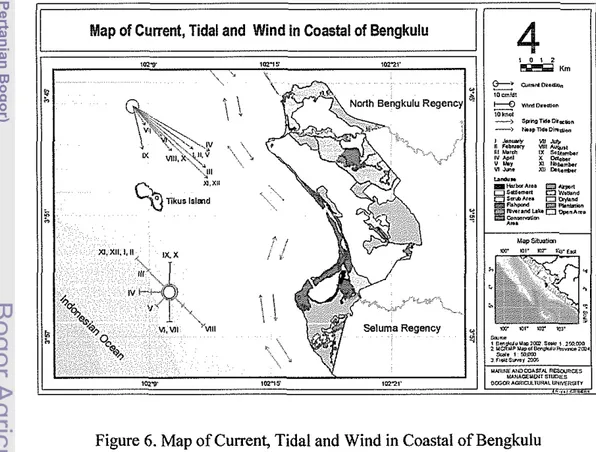
6 . Map of Current. Tidal and Wind in Coastal of Bengkulu...
7.
Number of tourists who visit to Bengkulu in 1997-
2004...
8.
Suitability Map for Land Based Tourism Activities...
...
9.
Suitability Map for Swimming Tourism Activities10
.
Suitability Map for Diving and Snorkeling Tourism Activities...
1 1
.
Coral coverage on Tikus Island. Bengkulu...
Page 6
11
13
LIST
OF ANNEXES
...
.
1 Step of data processing through GIS Procedure
...
2
.
Explained of main parameter for coastal tourism activities3
.
Interval score determination...
4.
Guideline of Scoring in SWOT Analysis...
.
...
5 SWOT Analysis
...
6
.
Standardization of water for tourism and recreation7
.
Questionnaire for community understanding of coastal tourism...
8.
Resulting of Lit Survey by Scuba Diving on Tikus Island, Bengkulu 9.
Wave high in coastal of Bengkulu Municipality Area (2005)...
10
.
Wind speed on Coastal of Bengkulu Municipality (2005)...
11.
Result of water sample analysis...
12.
Climate Condition of Bengkulu Municipality in 2004 and 200 .2003.
.
13 Figure of Research Activities
...
14.
Figure of Study Areas...
Page
65
67 70
72
78 81
82
83 84
85 86
INTRODUCTION
Background
Indonesia is the largest archipelagic state characterized by around 17.508 islands and 81.000 km coast length (Soegiarto, 1976 in Dahuri et. al., 1996), beautiful nature coast and the diversity of flora and fauna inside. There are coral reef and many kinds of the ornamental fish that estimated approximately 263 kinds (Nugroho, 2004). This huge potency is very appropriate to utilize and develop for coastal and marine tourism.
Bengkulu is a coastal city, located in the west coast of Sumatra Island, accordingly it is highly potential area to develop for tourism. The tourism sector is one of the development priorities that have contributed much to the economy of Bengkulu, although the contribution of tourism sector is not written factually. Stated on the Regional Gross Domestic Product (GRDP) of Bengkulu 2003, the close related sector of tourism such as trade, hotel business, restaurant (22,18%), transportation and communication (31,50%) are the economics sector that gave the highest contribution to Bengkulu development (Bappeda, 2004a). On the other hand, the trend of Bengkulu tourism development is under developed for the time being as the number of foreign tourist are decreasing, although domestic tourist rise slowly (Disparta, 2004). Should tourism be improved, it is expected to contribute higher income and accordingly for the increasing of community welfare. This could only be realized through a good planning in tourism which counts all influencing aspects on region development such as physical, social economics, and culture.
The coastal tourism development usually is started with an area planning, which zone of the region is suitable to be developed for the tourism area. The unplanned development or wrong planning will cause the declining of the coastal resources quality, especially on location determination of coastal tourism development. Unplanned development has contributed largely to the degradation of an already stressed marine environment (Turner, et a]., 2000).
The study on land suitability for costal tourism development is needed to obtain a system of sustainable development management of coastal tourism in Bengkulu. Without a good management of the tourism development planning, the declining of tourism quality will be faced, as a consequence of the lost of interesting value area (Baehaqie, 1993).
An analysis of coastal resources for tourism development that involve land suitability and development strategy is required and will become an initial input for Bengkulu government in determining their future policies.
Issue Formulations
Nowadays, the marine based tourism (coastal and maritime) denotes one of the interesting tourism products of the international community. The marine tourism development objective is to utilize and evolve the tourist spots and attractions in the coastal and ocean. Unfortunately the priority of resources management is given more to their mainland compared to their coastal and sea resources, especially the coastal tourism management.
Bengkulu region consist of large area with several potential that could be developed for coastal tourism activities, but right now those ideas still faces to some important issues as follow;
1. Coastal tourisln is still not optimally managed where still find the promising nature resources that are poor maintained.
2. Tourism information is still not available and an accurate data is difficult to find, as the result is the less planned in tourism promoting.
Objectives
1. To identify all the coastal resources that could be used as tourism attraction.
2. T o provide a zonation of coastal tourism based on suitability analysis.
3. T o formulate a development strategy of coastal tourism which guaranty the acceleration and sustainability of tourism in Bengkulu.
Benefits
1 . For the government especially to Bengkulu Government, the study resulting could be used as the inputs about the policy foundation development of coastal tourism in order to support the vision and mission of the city development.
LITERATURE REVIEW
Intro
The coastal area is the area where land meets sea (Sverdruf, 2006); on the land side both dry and remained water, still is affected by characteristics of the sea such tide, sea wind and salt infiltration; whereas on sea side still is influenced by natural processes that occur in the land such as sedimentation, freshwater and human activities in land such as deforestation and pollution (Dahuri et. al., 1996). Such situation may be found in bays, lagoons, estuaries, small islands (Clark, 1995), cliffs, dunes (Sverdruf, 2006), river deltas, coastal plains, wetlands, beaches and dunes, reefs, mangrove forest, and other coastal feature (Post, 1996). Moreover, Arancibia (1999) pointed out to use a broader and more functional definition of coastal area whose flexibility permits considerations of biological, biophysical, social, and economic aspects. It is defined as the geographic space in which the principal interchanges of material and energy are produced between the marine and terrestrial ecosystems. The coastal area occupies less than 15% of the earths land surface. Only 40% of the one million krn of coastline is accessible and temperate enough to be habitable. Yet it accommodates more than 60% of the world's population (FAO, 1998).
Interaction between land and sea ecosystem is very dynamic and affected each other, so more susceptible to each human activities in the land (waste, mangrove deforestation, erosion, etc.) and in sea (oil layer, coral reef destruction, etc.), the global climate change (sea level rising) and also natural disaster (tsunami, storm, etc.) (Ditjend-Bangda, 1999)'. The coastal and ocean area have important role on sea transport, harbor, industrial, recreation and tourism, settlement area and also waste disposal from mainland.
As an ecosystem, the coastal area is formed through natural process such as coral reef, mangrove, and sea grass and also gotten artificially; like fishpond, tide paddy-field, tourism, industrial and settlement area (Dahuri et. a]., 1996).
Coastal Tourism Paradigm
Many expert have defined tourism, among of them is Mathieson (1982) who stated that tourism
is
temporary movement of people to destinations outside their normal place of work and residence to satisfy his need. In Tourism Indonesian Law No. 911990 that tourism also is defined as everything that linked to tour, including attraction and all of efforts that related to its (Gunawan, 1997).The tourism area is a region with certain wide that built or provided to satisfy the tourism. In old paradigms, tourism emphasize to mass tourism which characterize number of tourist and various tourism package (Faulkner, 1997), and it become new paradigm of tourism now, that is modern tourist who have experience and autonomous, one destination to find flexible recreation, variety and specific motivation to nature. Further stated that ecotourism is group of tourism object and their attraction emphasize to nature. The ecotourism society purposefully travel to natural area to understand the culture and natural history of the environment, taking care not to alter the integrity of the ecosystem, while producing economic opportunities the make the conservation of natural resources beneficial to local people.
Whereas coastal tourism is defined as recreation activity in coastal, such as enjoy the coast, sand, sea and sunbathed (Wong, 1991), swimming, surfing, diving, canoeing, walking along the coast, enjoying the beauty of the coast, and meditation (Dahuri et. al., 1996). This tourism is often associated with three " S "
(Sun, Sea and Sand)(Wong, 1991), its meaning is tourism that provided beauty and natural comfort from the combination of the sunlight, sea and clean sandy beach. Even Miller (1991) added one "S" (sex) which has become one of the new
out continuously. This directly involved the natural environment including the sustainable culture and ecology aspect and also stressed to the community participation on surrounding area, they will involve conservation goal of resources in future.
Coastal tourism concept embraces the full range of tourism, leisure, and recreationally oriented activities that take place in the coastal areas and the offshore waters (Hall, 2001). These include coastal tourism development, such as: accommodation, restaurants, food industry, and second homes and its infrastructure such as: retail businesses, marinas, and activity suppliers. It's also included all tourism activities such as recreational boating, coastal and marine- based ecotourism cruises, swimming, recreational fishing, snorkeling and diving.
Tourism Resources
Although there is no standardized practice for reporting tourism statistics within the coastal zone, it is not to see how tourism has a major coastal aspect. The inherent character of coastal area makes its tourism distinctive (Zhang, 2001). Historically, the use of coastal zone for tourism dated to Roman times when holiday villas were available on the northern side of the Bay of Naples (Wong, 1993). Coastal area has various attractive resources for tourism activities, but it could be developed as sustainable and marketable tourism unless certain condition fulfilled such as attractive place, good accessibility and service, continuing promotion and information (Lewaherilla, 2002). Gunn (1993) has described tourism development including coastal area as the functioning component which each other have relationship component. Linked of those components is shown in Figure 1.
Attractions
m
Services
m
Information
m
Promotion
m
In document of TCMP (2001), it was explained that attractions could be divided into two categories: natural (wildlife, beaches, forests, geological formations) and cultural (historical or archaeological sites, performing arts, traditional lifestyles). Services including accommodations could range from basic campsites to luxury hotels. Whether budget or luxury, hotels need to provide value for a tourist's money. Standardized classification system is one way to ensure that hotels are providing quality accommodation at a fair price. Hotel owners and operators face constraints, however; high operating costs due to inadequate provision of utilities and telecommunications and taxes can often limit an investor's ability to do business successfully. Transportation can be by air, land or sea, but needs to be safe, a good value for the money, and reliable. Improving access to tourism sites allows more visitors to come, and also allows those visitors to go to more places.
Finally, management of coastal as nature tourism really need the participation of community on surrounding area, which is hoped will reach the targets (Anonym, 1997):
1. Maintaining the ecological process and system of life support in order to increase of community welfare and humankind quality.
2. Protecting the genetic diversity through protection of cohesiveness of the conservation area.
3. Guarantying the sustainability of natural resources utilizations and ecosystem through maintenance efforts towards the biodiversity capacity.
Tourism Product
entertainment facilities. Some facilities have mixed function such as swimming pool, which can be plain swimming lanes or added with other entertainment facilities.
As natural resources, the coastal zone consists of a myriad of ecosystems that can serve as potential tourism attractions. In addition to the natural sand beaches found at various places along the coast, the flora and fauna of the coastal zone can be considered attractions as well. Further, the extensive coral reefs that fringe the shoreline can be utilized by those tourists interested in snorkeling or diving. (TCMP, 2001)
Cultural heritage represents historical resources and shown the identity of a community and its environment. Cultural heritage can include monuments or other buildings that represent important events or eras in local or national history, traditional lifestyles, such as the performing arts and handicrafts, and even the everyday activities of local people as they farm, fish or prepare food. Tourists are becoming increasingly interested in learning about the people that live in and around tourist destinations in addition to more traditional tourist activities, such as game viewing and sun bathing. This cultural heritage can be developed into tourist attractions, which, in turn, can provide income generating opportunities for people living along the coast (TCMP, 2001).
Tourism Development
Cheong (2003) has explained about tourism development is based on the assumption that tourism is a two-faced industry consisting of public and private spheres. Tourist services such as accommodations and restaurants are managed by the private sector. Individuals or firms offer these services to obtain direct profit from tour operation. On the other hand, natural resources such as scenery, clean water, ambience, and fish as well as cultural assets of the place are considered public resources. Furthermore, the infrastructure often times provided by the government is essential to the smooth tourist operation.
touching and influence to natural ecosystem that supported. Each natural ecosystem in coastal area have 4 main functions to human life: (1) service of life supporting, (2) service of the comfortable, (3) provider of nature resources and (4) waste recipient (Ortolano, 1987). Based on the four functions of the ecosystem, there are three conditions that can guarantee the achievement of sustainable development that is i) spatial harmonious, ii) assimilate capacity, and iii) sustainable utilization. The selection activities in region have to consider the compatibility of the land or waters, the impact of the development activities especially pollution, sedimentation, change of hydrology regime, and the compatibility among development activities (Dahuri et. al., 1996).
Soeriaatmaja (1997) stated that the sustainable development is development that can guarantee the human requirement on present generation (in satisfying their need) without leaving the next generation. The aim of the sustainable development is integrate development and environment since the beginning of the policy process until their implementation. Conceptually, a development of sustainable coastal tourism can be interpreted as the tourism development that environmentally perception which not disturbing the condition of coastal resources, so they can be used continually until next generations. The natural tourism activities certainly give positive impacts, but also can bring negative impacts to environment either ecologically and socially. In general, the negative impact of environment could happens as a result of poor planning and management, for example those did not consider the environment capacity or lack of awareness, knowledge on environment conservation (Soeriaatmaja, 1997).
MATERLALS AND METHODS
Research Frameworks
Bengkulu coast region has great potential for tourism development with interesting scenery and white wide of sand beach. In other side, coastal tourism development also has opportunity to cause ecosystem damage, if it is unplanned such as mangrove conversion and sea casuarinas forest change settlement. Several problems also will be resulted from the tourism development that not enough planning such as mainly conflict of interests among related part due to no clear area development coordination yet, such tourism and forestry, public work and environment service, etc. Furthermore, not adequate institution as certain tourism areas management yet, lack of community's participation and declining of environment quality are found.
Many negative impacts have happened from the wrong planning towards nature characteristics estimation of the coastal area. Environmental damage that is resulted from storm, wave, wind, erosion and intrusion of sea water is main cause of the failure planning of the land use, so caused fragile of coastal ecosystem and even will damage the developed tourism infrastructure. Some causes that effect those problems is the accurate data and information are not available, there are no suitable analysis in the last planning and consistency of land use planning in implementation.
Initial step of the tourism planning is defining the objective of tourism, identify the resources, furthermore analyze and determine suitable area for tourism activities. Through the land suitability analysis, it is hoped that the development of the natural resources environment, which is an important factor in coastal tourism, could be still well maintained.
Integrated use of field surveys, remote sensing and GIS in coastal tourism has been used and proven to be useful. For examples: coastal tourism planning (Zhang, 2001), tourism spatial planning and the impact of urbanization and tourism on coastal environment (Burak et a]., 2004). It will be hoped that the sustainability of'resources could be maintained and the increasing of common prosperity for all the people can be reached. Research framework is illustrated in Figure 2 below.
Bengkulu Coastal
Area
1
f
Bengkulu City / n-4....~.. -2.3-I
Government1
/
ruLc"bY/
Coastal Tourism Issues and Problem
Development
.
RUTRW' Government Policy ofSpasial Analysis SWOT Analysis
Land Suitability of Coastal Tourism Development Strategy
-u=-
r
Bengkulu CoastalI
I
Tourism ~ e v e l o ~ m e n t PlanI
Figure 2. Research Framework of Coastal Tourism Development on Bengkulu.
Study Area and Sampling Site
The study location is in west coast of Bengkulu Municipality including Tikus lsland areas in the coordinate of 102"14' to 102"22' East and 3"45' to 3'59' South. The first study
is
called Pantai Panjang which means long beach. This area located at Sub District of Gading Cempaka with good accessibility; where cottages, hotels, restaurants and several public facilities could be found. Another interesting place is Tapak Paderi. This area is public park at Sub Didtrict of Teluk Segara with an old harbour that was built during English colonization, good view of sea scenery and also available the shallow waters (1-5 m). This area located in centre of city which is the marina being contracted, to support several tourism activities. Beside that the attractive place to be visited is Tikus Island as a Marine Park that surrounded by the coral reef as rich biological resources. This area situated around 7 km from Tapak Paderi.The study area is not including Pulau Baai Harbor in the southern; it is assumed that tourism activities should not be developed there since the area has already been allocated for conservation area (sea casuarinas and mangrove forest) and fishpond.
In order to investigate the tourism development planning of coastal tourism, sampling sites were determined representing the area along the west coast and surrounding Tikus Island. Those stations were sampled for physical, chemical and biological parameters. Study area and sample station is presented in Figure 3.
Data Collection
The data consisted of primary and secondary data that collected through observation, questionnaire and interview which was conducted during March to May 2006.
1. Primary Data a. Water quality
BENGKULU MUNICIPALITY
Map Situation
i.BonpliviY MapZW2,Scsie 1 :2W.000 2.MCRMP M B P D I B D ~ Q L Y I Y Provinca2001,
Scalo 1 : M O W .
MARINE ANDCOASTAL RESOURCES MANAOEMENT STUDIES BOGOR AORICVLTURALUNlVERSlTY
-
turbidity, wave height, oil layer, surfactant, and Escherichia coli. Each parameter was taken on 9 stations with 3 replicates.
The clarity was measured by using secchi disk and current speed by current meter. Water depth was calculated from Landsat image analysis and wave height through estimation by wind speed. Water sample was taken in the field to be measured later in laboratory. The sample was intended for determination of turbidity (Nephelometric method), oil layer and surfactant (spectrophotometer method) and Escherichia coli (MPN method).
a. Coral Environment
Field observation on coral reef was performed to determine coral type, coverage as well as coral fish. This action possible due to diving and snorkeling which has been conducted through lit survey with scuba diving. b. Community Perception (Questionnaire)
In order to know the community perception on coastal tourism, the unstructured questionnaire was distributed to gather information to several respondents, how did they known more understanding on coastal tourism development which has been done interview and discussion to all respondent. In order got more information and easy to be done, accidental sampling was conducted for local community (16 people) and tourists (8 people), and purposive sampling for community leader (4 people), government officer (7 people), and travel agency (5 people).
2. Secondary Data
Secondary data was collected to obtain the information about social, economics and culture. Other data could be obtained is given from observation on the field such as climate, temperature, wind, tidal condition, distance from coastline, land utilization, coast type, accessibility, disaster area, fresh water source.
BPS', Tourism Service on Province or Municipality level, University, and Research Consultant. The other supporting data such as:
a. Health facilities
b. Regional Gross Domestic Product of Bengkulu Municipality c. Potentials of the Nature Resources and Environment
d. Location of tourism object
e. Number of tourist with their characteristic. Maps requirement that is used such as;
a. Digital map of Bengkulu Municipality on 2002 (scale 1:70.000), b. Map of the spatial plan, 2002,
c. Landsat 7 ETM Image on February 2003,
d. Coastal Atlas of Bengkulu Province that has been issued by MCRM Project, 2005.
Data Analysis
All data is compiled with Microsoft EXCEL for further analysis using Geographical Information System (GIs) Program (Arc Info Ver.3.4.2 and Arc View Ver.3.2).
1. Spatial Analysis
The step of spatial data processing through GIs database procedure is showed on flowchart in Figure 4 and is explained briefly in Annex 1.
2. Determination of tourism area with suitability method a. Determination of suitability matrix
This method is adopted from the analysis technique for land suitability that is developed by F A 0 (1976). Each variable is given by the value showing three categories, that is very suitable (VS), suitable (S) and not suitable (NS) (DPU, 1997)'.
'
Biro Pusat Statis:ik (Centre Statistics Boa~.d, Republic of Indonesia)Data Collecting
Land Suitability Analysis
e Very suitable (VS)
The area have not significant limitations to sustained application of coastal tourism development as given use, or only minor limitations that will not significantly reduce benefits and will not raise inputs above an acceptable level (FAO, 1976). The color for this area will be used green.
Suitable (S)
The area has rather serious restraint for the activities of coastal tourism development. This restraint will increase input or treatment that is needed. The color for this area will be used ycllow.
.
Not suitable (NS)The area have limitations which appear so severe as to preclude any possibilities of successful sustained use of the land in the given manner for coastal tourism development (FAO, 1976). The color for this area will be used red.
b. Weighting
Generally, this method is used in planning which have qualitative dimension variables. Each suitable variable is given weight that is determined by contribution of variable to achieve the target of space utilization. How far a region can fill the criterion that is determined by suitability variable, it determines the number of scores that is received. The suitable calculation is carried out by multiplying weight to score and results of multiplication for all variables. If results reached or exceeded a certain value then utilization activity can be stated appropriately.
Weighting is divided into 3 criteria as follow;
Primary parameter or main condition is used for a development activity of coastal tourism is given by the weight 4-5;
Secondary parameter for parameter that can be dealt with technology is given by the weight 2-3; and
The scoring is used 3 criteria with value of the score that is;
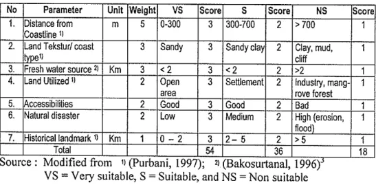
Score 3 for parameter that have appropriateness very suitable (VS) Score 2 for the parameter that have appropriateness suitable (S) Score 1 for the parameter that have appropriateness non suitable (TS). The matrix of land suitability for coastal tourism activities in Bengkulu is shown by Table 1, 2 and 3 which is adjusted to land based, swimming and diving snorkeling activities repeatedly.
Table 1. The scoring and suitable matrix for land based activities
VS = Very suitable, S = Suitable, and NS = Non suitable
Table 2. The scoring and suitable matrix for swimming
No
1. 2.
VS = Very suitable, S = Suitable, NS = Non suitable. NTU = Nephelometric Turbidity Unit.
-
Parameter Current speed 31
Wave height
5
, 3
3 Badnn Koordinasi Survey dan Fernetaan Nasionai (National Mapping and Survey Coordination
Board, Republic of Indonesia)
3. l ~ e ~ t h 21 m
1
3 0 - 5 3 5-10 2 > l o 11
Score
2 2
Unit
mlsc
rn
0-0.1
0-0.2
Weight
I
VSI
ScoreI
S NS> 0.4
>1.0
Score
1
1
3 3
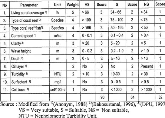
Table 3. The scoring and suitable matrix for diving and snorkeling
,.
.
VS = Very suitable, S=
suitable; NS = Non suitable, NTU = Nephelometric Turbidity Unit.6.
Interval score determination is conducted according to statistic theoretic trough use the minimum and maximum value of each total score, its can be made the class wide.
The formula that is used :
7.
1
Depth 21 m ( 3 1 0 - 5 3 1 5 - 1 0 2[ > l o
( tWave height
Class wide =maximum
-
minimum2
I
m
1
3 1 0 - 0 . 2 1 3 10.2-1.01 2 1>1.0I
1The interval of three matrixes above is presented in Table 4, whereas the detail step of this is presented in Annex 3.
Table 4. Interval score for coastal tourism Activities
Land Based Swimming
Diving and Snorkeling
Very Suitable 45 - 54 48
-
57 80 - 96Suitable 27
-
44 29-
47 48-
793. Overlay
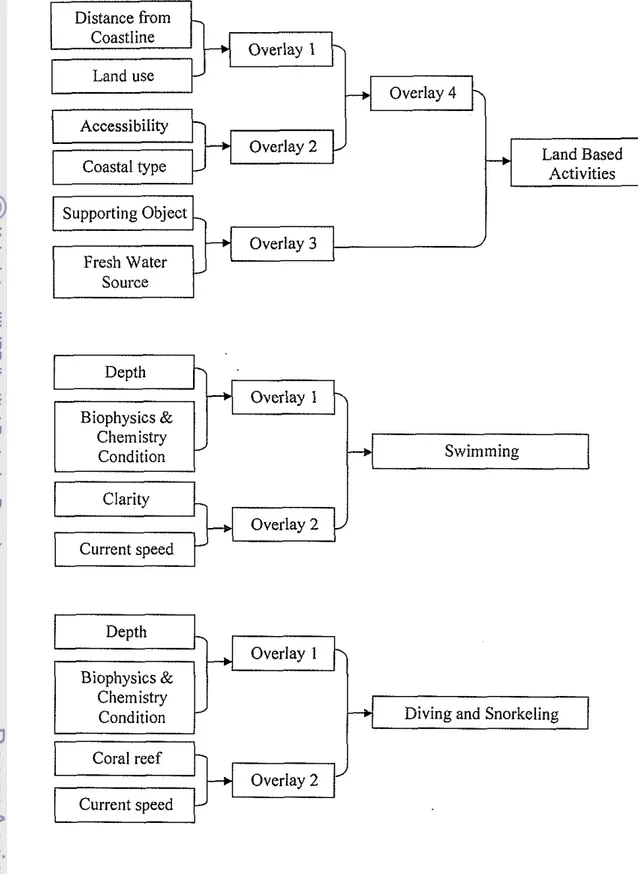
Overlay of map is a process of uniting the spatial data (the map) that is used in the layout plan (Ortolano, 1987). Overlay for the compilation of the tourism area is presented in Figure 5.
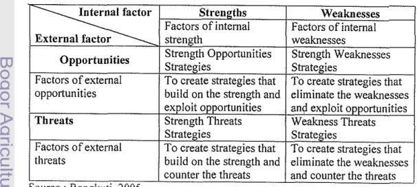
4. SWOT Analysis
Basically this analysis is built to determine the strategic planning. Output of SWOT analysis is basic information structure of the general real understanding and choice group of strategic development (Zwaenepoel, 1999). The SWOT analysis is able to identify some determinant factors prior to formulating the strategy planning. This analysis is based on logic by maximizing the strengths and opportunities, but simultaneously minimizing the weaknesses and threats (Rangkuti, 2005). The steps of SWOT is 1) Collecting data is external and internal evaluation; 2) Analysis is make external internal matrix and SWOT matrix and 3) Decision making
All required information are put into a matrix that clearly depict the opportunities and external threats which matching to strengths and weaknesses (SWOT Analysis). The matrix will produce several possibilities of strategic alternatives, which decision to be done to contend with weaknesses and threats of coastal tourism management (Marimin, 2004). Matrix of SWOT Analysis is presented in Tabel 5.
Table 5. Matrix of SWOT Analysis
Strengths Weaknesses Factors of internal
I
Factors of internalthreats
Distance from Coastline
Overlay 1 Land use
Overlay 4 Accessibility
Overlay 2 Land Based
Coastal type Activities
Overlay 3 Source
Clarity
Current speed
Depth
k
Depth 7
Overlay 1
Diving and Snorkeling Biophysics &
Chemistry Condition
Coral reef
Overlay 2 Current speed
Figure 5. The overlay for regional suitability of coastal tourism (upper), swimming (middle), diving and snorkeling (lower)
Overlay 1
J Swimming
BENGKULU MUNICIPALITY
Geology and Climate Condition
Bengkulu Municipality is the capital of the Bengkulu province, situated in the West Coast of Sumatra along the north to south direction. Its area is about 144.52 km2 with coastline is about
+
60 km including Tikus Island, located in the coordinate between 102'14'- 102'22' East and 3'45'-
3'59' South. The northern and eastern is North Bengkulu Regency, Seluma Regency in the southern, and Indonesian/Indian Ocean in western part doe to geographical location, takes implication to coastal tourism may be developed as, availability of the object and attraction on its coastal environment.In General, the coastal area elevation bctween 0 - 16 m above sea level and the widest area is between 0
-
10 m that is about 10.248 ha (70.91%). Geologically, sea floor of the coast and mainland is dominated by subduction of the lndo-Australia plate that crust into Eurasia plate. Tectonic action result the formation of beniof seismic in the sea floor as an active earthquake zone. The coast area is characterized by the open gulf with slightly slope and low relief. Geologically, the morphology and characteristics of shoreline of the Bengkulu coast from northern to southern is divided into three types as follows:Muddy and CliffCoust
This type is along the coast, from Pekik Nyaring Village to Pasar Bengkulu Village. Coast characteristic is low relief, beach width is 50-100 m, the slope is 30-50%, and part place is muddy with low sand nearby the estuary. It also found the accretion of new sediment as clay sand which results from sedimentation process in estuary.
Pocket Beach and sea wall
*
Sun& Beach and CoralThis type located along Berkas Village which is characterized by slope, low relief, beach width between 100-300 m, slope around 30-50%, sandy beach, limestone from reef fragmentation. Commonly, the contour is parallel between shoreline and bathymetry at depth between -3 to -32 m.
The wind is influenced by southeast monsoon that blows from the west, southwest with average velocity 18 knot or approximately 10 I d h o u r . During the west season, the wind blows from the west with speed up to 40-60 kmlhour caused big wave in coast and inhabited fisherman activity. This season is known by the local people as the Goloro season. The west wind occurs during December
-
Febmary (maximum on January around 16 knot from northwest) and the east wind occurs between June -August (maximum on August around 14 knot from southwest). During transition season, wind blow vary to all direction where this condition is presented in Figure 6.According to Koppen classification, the climate of Bengkulu is ordered to Afin class that have wet tropics climate with mild warm temperature. The variation of rainy and dry season is not too visible. Base on Schmidt and Fergusson, the rainfall includes to A type with the highest rainfall between October
-
January (more than 300 mmlmonth) and minimum rainfall is more than 100 mmlmonth. The temperature of region is between 20.5 - 33.8 "C with humidity 82-
69%. The climate condition of Bengkulu in 2004 and 200 -2003 is presented in Annex 12.Oceanographic Condition
The tidal move on from west to south-east during the high tide and back to north-west during the low tide (Bappeda, 2004b). Based on forecasting of Dishidros in 2004, the tidal type of Bengkulu is mixed tidal with dual domination (semi-diurnal). Variation of the high tide and low tide of sea level is between 0.3 m (neap tide) and 1.4 m (spring tide).
The current pattern of Bengkulu coastal is resulted from three combination of current i.e. regional current that flowed to south-west on the west coast of Sumatra, tidal current and long shore current that formed from breaker wave zone. The speed of surface current flow between 6
-
26 cmlsc, where maximum speed occurs during west season and minimal speed during east season (Bappeda, 2004b).Wave character is observed in coastal area is affected by direction and wind speed in the open sea. The monthly wind speed varied between 4-16 knots that could generate wave height between 0.1-1.4 m. The Bengkulu coast is opened to the all wind direction and wave energy is strong, resulting the highly abrasion process in the coast. Materials eroded by wave will be transported by long shore current along the coast.
In generally, the water quality is relatively good, except the elevated turbidity in the estuaries resulted from sedimentation process in the up land. Some physical and chemical parameter of coastal water in the study area showed that turbidity is 0.001-5.430 NTU (average 0.009 NTU), clarity
is
2-15 meter (average 6.9 meter), and oil spill, nitrate, phosphate is not detected. BOD is average 60.00 mgll, COD is average 140.00 mg/l, temperature is between 28.0-30.0 "C (average 29.2 'C) (Bappeda, 2004b), and surfactant is between 0-0.088 mgll (average 0.014 mg/l). The biological condition was depicted by concentration of Escherichia Coliwhich is in the range of 0-20 se1/100ml, even several places is not detected.
Socio Economics and Socio Culture Condition
By the end of 2004 the total population of Bengkulu was 261,440 people with the density 1.81 people per km2. It is shown that Bengkulu is relatively dense city where generally communities live at Gading Cempaka Sub District (142,270 people and 4.98 people per km2) and Teluk Segara Sub District (40,560 people and 4.43 people per km2)(~appeda, 2004b). All of social economic activities often occur at this area such as government, market, education, hotel, restaurant, public service etc.
Education facilities consisted of kindergarten is 65 units, elementary school is 92 units, junior high school is 33 units, senior high school is 35 units, and University is 10 units. Health facilities consisted of Public Hospitals is 1 unit, Psychiatric Hospital is 1 unit, Private Hospital is 2 units, local government clinic (LGC) is 16 units, and auxiliary LGC is 49 units and is supported by 356 medical staff.
Ganzat, Gambus as combination of traditional music and poetry, and other traditional coastal ceremony.
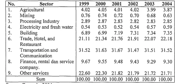
During 1999-2004, the economic growth of Bengkulu Municipality almost did not have the significant variation. Transportation and communication, services and trade, hotel restaurant sectors always gave biggest contribution to Regional Gross Domestic Product (RGDP) of Bengkulu. Those sectors are close related sector to tourism where almost all of tourism activities have connection to hotel, trading, transportation, and communication, even though contribution of tourism sector is not written factually on RGDP of Bengkulu. This condition is presented in Tabel 6.
Table 6. Distribution of Regional Gross Domestic Product of Bengkulu, base on constant price on 1993 and 1993-2004.
No. Sector
1. Agricultural 2. ~ i n i n g
3. Processing Industry 4. Electricity and fresh water 5. Building
6. Trade, Hotel, and Restaurant
7. Transportation and Communication
8. Finance, rental dan service company.
9. Other services Sum Source: Bappeda, 2004a.
Bioresources
1. Mangrove
Ecosystem of mangrove forest in Bengkulu is relatively small portion in the coastal and its locations disperse, so the existence of mangrove is only little effect to this area. Mangrove ecosystem could be found in the Subdistrict of Selebar as be precise in exactly in Padang Serai and Kandang Village of Pulau Baai region close to Jenggalu River, but this area is not include in study area.
further upland is found Rhizophora apiculala and Bruguiera gymnorrhiza, ended with Lumnifzera litorea (Bappeda, 2004b). The species of mangrove is presented in table 7.
Table 7. Composition of Magrove forest in Pulai Baai.
No Species Family Local Name 1. Sonneratia alba J.E.Smith Sonneratiaceae Pidada
2. Rhizophora apiculata B1 3. Avicennia ntarina (Forsk)
4. Ceriops tagal (Perr.)C.B.Rob
5. Bruguiera gynznorrhiza (L..)Lmk 6. Cerbera manghas Gaerth
7. Lunzintzera litorea (Jack.)Voigt 8. Hibiscus tiliaceus L
9. Xylocarpus granatunz Koen Source: Bappeda, 2004b.
Rhizophoraceae Avicenniaceae Rhizophoraceae Rhizophoraceae Apocynaceae Combretaceae Malvaceae Meliaceae
Bakau Api-api Bakau Tanjang Macang Laut Terentang Waru laut Nyireh
2. Coral Reef
Coral reef is found around Nala Beach, Tikus Island and southern of Pulau Baai port. These are fringing reef around Tikus Island, it is found coral reef in good condition with coverage 78.67 %. Generally, the growth of coral reef considered to be low shown by short appearance indicates high energy of current and wave there (Bappeda, 2004b).
Table 8. Coral reef in Tikus Island.
3. Fishery
Base on Regional Gross Domestic Product (RGDP) of Bengkulu Municipality in 2004, contribution of fisheries sector was Rp. 14,139,000 or 65.7
% from total of agriculture sector. The contribution of fisheries sector during last 5 years that continued to increase as showed in Table 9.
Category Coral Dead Coral Acropora Branching Submassive Tabulate Non-Acropora Branching Massive Encrusting Foliose Submassive Heliophora sp Other Life Form
Sponges
Other Benthic Life Form
I Coralline Algae
Algae Assemblage Substrata
Ruble
T o t a l Source: Bappeda, 2004b.
Table 9. Distribution RGDP of Bengkulu in Agriculture Sector which according to Constant Price in 1993 (Rp. Million).
Covered (%)
14.00 3.63 0.67 0.00 7.83 25.87 3.67 1.00 34.33 1.67 0.33 2.33 2.33 2.33 100.00
4. Fisheries
1
12,435 12,975 13,760 14;139 14;395Sum
1
19,053 19,981 21,053 21,520 22,009Source: Bappeda, 2004a. No. Sub Sector
1. Food 2. Plantation 3. Livestock
Year
2000 2001 2002 2003 2004
2,033 2,168 2,235 2,265 2,290
7 8 11 15 17
The fisherman and fish fanner condition from the year to year is seen to increasing but not too high, for more information is showed in Table 10. Fisherman in Bengkulu is still relying to boat without motor and boat with power 5 GT for capture fisheries. Lack of capture fleet caused development of fisheries did not yet increase optimally and capture route is only in the coastal of Bengkulu. Commonly fisherman used very heterogeneous of equipment and dominated by fishing, resulting the multi-species of fisheries resources.
Table 10. The Fisherman and Fish Farmer condition in Bengkulu on 1992-2004. Brackish
W a t e r F a r m e r 27 34 32 35 36 38 42 45 47 52 55 55 56 Year 1992 1993 1994 1995 1996 1997 1998 1999 2000 2001 2002 2003 2004 Fresh Water F a r m e r
112 118 114 120 126 131 226 228 23 1 234 24 1 245 245 Fisherman 2,463 2,488 2,484 2,491 2,615 2,621 2,864 2,864 3,034 3,187 3,215 3,238 3,764 Tourism Statistic
The other infonnation they have from friend and family who ever visits to Bengkulu (Harmes, 2002).
1
Domestic Tourist/
1 Q m ~ ---
Foreign Tourist
m 7
----
h j
m -
BO -
/
\
--
so.
\ 1
Figure 7. Number of tourists visit to Bengkulu in 1997
-
2004 (Disparta, 2004).By average, the number of foreign tourists to Bengkulu is 531 people and domestic 67,992 people per year, making the total average 34,261 people. It is shown that the number of tourists both domestic and foreign were still low, then it result to the low of tourists expenditure as input to all sectors that connected with tourism. This matter will pushed to local government to try and develop this sector continuously as soon as economy development, where the sector that had relationship to tourism activity such as the trade, restaurant hotel and co~nmunication transportation as prominent sector in RDGP of Bengkulu.
RESULTS
The assessment of tourisrn is started with exploration of coastal zone of Bengkulu which covered to condition resort attraction, accessibilities, accommodation, supporting facilities, management, institutional, human resources and also infrastructure. Furthermore the understanding of tourists who visit to Bengkulu, covered foreign and domestic tourists.
In order to be able to become the supreme sector in local development, then necessary the basic knowledge of tourism problem, so its will be found the solution and how the attempts to develop them. One of main problem is still many objects, tourism attraction, infrastructure not managed and developed optimally yet. Beside that institutionally, there is not good coordination yet, accessibilities still far from the overseas gate, and lack of human resources.
Existing Tourism Zone and Attraction
The main coastal tourist attraction is nature tourisms that had taken by the history and culture tourism. The coastal tourism object of Bengkulu from northern to southern is showed in Table 11.
Table 11. Coastal tourism object in Bengkulu.
No.
2.
1.
I
Jakat Beach1
100.001
Coastal recreation Tourism ObjectTapak Paderi Park
3. 4.
5 .
6 .
8. Pasir Putih Beach Marlborough Fortress Thomas Parr Monument Old Chinese Village Pantai Panjang and Nala Beach
7.
I
Source: Bappeda (2004b), D i s ~ Wide (hectare)
Tikus Island Marine Park
Coastal panorama with old harbor, open theatre, swimming activities and traditional fisherman.
Culture site
Culture site in trade centre Centre of old town
Natural panorama, clean sandy beach, recreation facilities, hotel, cafe, cottage & restaurant, sea casuarinas, have the site plan. Maritime panorama, maritime &
sport tourism, sunset, fishermen activities.
Fishing, seaport, maritime tourism, natural panorama and sunset.
The table showed that there are many object of developing tourism in coastal area and they needed supporting of tourism facilities such as accommodation, travel agency etc. Until 2004, the available accommodation is still very limited that spread only in Gading Cempaka and Teluk Segara Sub district. Hotel facilities had consisted o f 4 unit luxury hotel, 26 unit ordinary hotel, and 11 unit small hotels with totally 1.150 beds. Its also available 45 units restaurant where some of them provide international food. There is also available 6 units travel agency, 3 units sport facilities, 5 unit swimming poll, 8 units billiard house, 5 units pub and 12 units art shop for tourism supporting.
The tourism sector could give as possible much benefit to area, so that tourism potential should be integrated, responsibility and sustainability. The coastal tourism object divided to some zone, these are intensive, extensive and semi extensive zone, in order to make easy to develop the attraction.
1. Intensive Zone
a. Pantai Panjang and Nala Beach
Various tourism activities could be done such as panorama watching, sunset, fishing, camping and recreation as the tourism park. The public's facilities such luxury hotel, cottage, restaurant, recreation facilities, and shop are available along the coast. A great number of hotels have already been built along the coastline, and many are still under construction. Accessibilities are good through city transport each time is available. Tourism retribution as the source of income government reached Rp.60 millionlyear. The highest visitors occur on religion and New Year celebration. Object management is managing by Forestry Service of Bengkulu Province, Tourism Service of Bengkulu Province, Finance Service of Bengkulu Municipality, and Cleaning Office of Bengkulu Municipality. The planning of tourism development of Pantai Panjang was arranged on 1992 by Tourism Service of Bengkulu Province.
conservation areas that located in the city, exactly on southern part. Administratively this region located in Gading Cempaka Sub district, whereas geographically located between 102°15'14"
-
102°19'48" East and 3'47' - 3 '57'30" South.b. T a p a k Paderi P a r k
The main attraction is old harbor that was built by English colonizer period, sea scenery and shallow water that is not dangerous for swimming or water bathing. Various tourism activities or coastal recreation could be done such as water sport, panorama watching, sunset, fishing, and other coastal tourism activities.
This area located in the Malabero Village next to Malborough Fort. Total area is around 32.50 hectare where is available 1 unit discotheque and 2 unit billiard arena.
c. J a k a t Beach
The tourism attraction that is available at Jakat Beach such as spread sandy beach, sunset, fishing activities, and landing of ship where a lot of traditional fishermen lived around the coastal area from Pasar Bengkulu Village until Jakat Beach. They work together as the specific tradition while ship landing and direct selling of catch fish conducted by fisherman to local people and traders (auction activities).
Total area is around 100 hectare with elevation is 0-1.5 meter which suit as centre of the sea bathing place to community and visitor and rent boat for fishing. The road along coast gave the good accessibilities so is easy to visit because it is only 1 km from the centre of the city.
2. Extensive Zone
a. Marlborough Fortress
The Fortress located on the old city centre, close to Chinese settlement which also has the historical value as beginning of Bengkulu Municipality. The fortress had special uniqueness that is not found on the other fortress in the Asia where it was the second basis of English colonizers in the far eastern.
b. Thomas P a r r &Hamilton Monument
This monument is built to commemorate two British residents who lived and died in Bengkulu, they is Resident Parr and Resident Hamilton. Monument is point of zero kilometers of Bengkulu Municipality and located around old City centre, faced of the Barukoto shopping centre. Almost 1.5 kilometer of this place is found the funeral of European citizen especially British troops who lived and died in Bengkulu. This cemetery is a historical tourism attraction especially British citizen who visited. The condition of the cemetery is maintained enough and could be as specific attraction for tourists.
c. Chinese Settlement a t Old City
The settlement is faced to Marlborough Fortress at city centre that is one of the busy trading. The buildings made specific Chinese model as historical atmosphere. This place is beginning of Bengkulu establishment and one of settlements that often are lived by Chinese traders now.
The new phenomenon emerged in this area is growth the swallow nest production on the upper house of community. Earlier, the building only had 2-3 floors and then is built until 7 floors as swallow nest.
3. Semi Extensive Zone
a. Marine P a r k of Tikus Island
Tikus Island is surrounded by coral reef as rich of marine biological resources. This park had decided as the tourism forest through Minister Decree of Forestry No. 602Kpts-111991. Total area is 300 hectare which consist of 2 hectare mainland and 298 hectare shallow waters.
The vegetation that grew in Tikus Island consists to coconut tree, ketapang, waru and pandanus etc.
The potential of fauna is coral ecosystem and sea biota. Various birds such black heron birds (Egresa sacra), sea pension (Duluca bicolor), kowak (Nycticuray sp) and rice pecuk birds (Polocrocoray sulsinotris). The coast is white sand and also as habitat of sisik turtle (Eretmochelys limbricata) and green turtle (Chelonia ~nydas) where went to upland to lay eggs ,and spawning at the night. There are the safe locations for diving and snorkeling. This area is very potential to be developed as the maritime tourist attraction or activity other as enjoying beauty of the coral reef ecosystem, fishing, sailing, snorkeling and diving.
The area could be reached by boat about 30 minutes or by the fisherman's traditional boat between 1-2 hours. It is also available the rental transport to go to the island, but is not available the regular transport.
b. Pasir Putih Beach
The main activity is maritime tourism, natural scenery, fishing and other activity of harbor because it located close to Pulau Baai harbor. It has around 18.50 hectare and distance 10 kni from centre city which consists to sea casuarinas forest (conservation area). The public's transport every time is available from city terminal or Pagar Dewa sub terminal. This beach also could be reached through ship or fisherman boat from Tapak Paderi and Jakat Beach.
For fulfillment of the tourist requirement such as accessibilities has been available 4 flights from and to Jakarta every day, regular ship that served from Bengkulu to Enggano Island every week and regular transport that connected to other cities in Sumatra and Java. Also there is available the regular city transport that arranged to service to all place in city.
Area for Land Based Activities
Spatial analysis results that in the coastal area of Bengkulu names very suitable, suitable and not suitable for land based tourism activities. The very s ~ ~ i t a b l e area is found in Pantai Panjang, Tapak Paderi and Jakat Beach, making up to area of 98.63 hectare with its circumference of 15.37 km. Regarding to suitable area category stand for Pasir Putih Beach, Pasar Bengkulu Beach, Teluk Sepang Beach which total area approximately 1,051.73 hectare and 66.58 km of surrounding. The last, which is not suitable area is the other areas that not included in first two categories, that is about 2,060.92 hectare and 51.62 km of surrounding. Results of the spatial analysis of suitability area for land based activities are presented in Figure 8.
Very suitable beaches are characterized by distance, white sandy, good accessibilities, fresh water source, absence of natural disaster (erosion and flood) which makes significant contribution for coastal activity. Moreover, for coastal area in Tapak Paderi is close to and supported by the existence of historical landmark; Marlborough Fortress which is located only 50 m from shoreline and also there is being built to marina as support maritime activity as well as tourism. The existence of the site will become special attraction for tourist, where while enjoying the panorama of natural coastal and sunset, they also could learn the history of the struggle of Indonesian nation in fol-tress. Beside this condition, the total score of analysis tabular is 440
-
510, therefore it is considered as verysuitable location for land based tourism activities.
Legend
coastal Tourism sultabilny
8
Non Sultablc 5Suitabls 10
w
v q S"....
26
#.. r k HlStOnCBlSile M
#/'\./ Road 100
150
SOWCB : w o woo
1. Beo~Aulu Msp2002. Scsle1:250rCO .?no 2600
2. MCMRP Mapof Bewkuhl PrnMieZOW. MARINE AND COASTAL RESOURCES
Scaie 1 : 50.000 WKAGEKENT STUDIES
3. meid Suney m6. BOMR AGRICULTURAL UNIVERSITY
CI E f r i 2 e l C251PIOIl4
Figure 8. Suitability Map for Land Based Tourism Activities.
Although the area is protected coastal forest where human activity could be done limited, some activities of coastal land tourism still could be conducted as long as not damage to habitat of sea casuarinas such as camping, birds watching, photograph, hiking, outbound, natural education etc.
support to land based tourism is the land use which characterized by coastal forest and settlement. Although in some locations is an open area but other parameter did not support. Furthermore the distance of the fresh water source is slightly difficult to reach. At the same time based on results of total score of tabular analysis is 21
-
26 so could be included to not suitable category.Area for Swimming
One important activity in coastal area is swimming. Results of the spatial and tabular analysis produced the very suitable, suitable and not suitable area for swimming activities. The very suitable is found along Jakat Beach up to Tapak Paderi which total area is 342.84 hectare and the circumference is 11.17 km. The suitable area is partly of Tikus Island which total area is 2,140.8 hectare with its perimeter 18.67 km. The not suitable area is the other areas which