POTENTIAL VEGETATION FOR SOIL AND WATER
CONSERVATION: CASE STUDY IN SAMIN
WATERSHED, CENTRAL JAVA
Maridi
1, Putri Agustina
2, Alanindra Saputra
11
Sebelas Maret University, Faculty of Teacher Training and Education
Jl. Ir. Sutami 36, Surakarta, 57126, Indonesia
2
Universitas Muhammadiyah Surakarta, Faculty of Teacher Training and Education
Jl. A. Yani Tromol Pos 1 Pabelan, Kartasura, Surakarta 57162, Indonesia
maridi@staff.uns.ac.id
Abstract
Samin is one of watersheds located in the districts of Karanganyar and Sukoharjo, Central
Java, Indonesia. Samin is a part of Bengawan Solo watershed that is classified into one of 282
Indonesian watersheds which are in critical condition. Research about vegetation analysis of
Samin watershed as conservation efforts have been done before and resulted in structure of
lower crop community (LCC) and tree vegetation. The purpose of this study was to analyze
potential plants, both LCC and trees, in Samin watershed that could be developed as a
vegetative water and soil conservation. The list of plants that were potentially developed as a
vegetative conservation obtained from the research before about analysis structure and
composition of vegetation in Samin watershed and literature review. The result of this
research showed that there were several plants with the highest Important Value Index (IVI)
and that can be developed for vegetative soil and water conservation. In tree vegetation, there
are
Tectona grandis
,
Delonix regia
,
Switenia mahagoni
,
Cassia siamea
, and
Samanea saman
.
These tree plants have a big canopy that can retain rain water through several mechanisms
such as interception, reducing direct flow, and producing litter layer. In LCC vegetation, there
were
Mimosa pudica
,
Ageratum conyzoides
,
Tridax procumbens, Oplismenus burmanii,
Chloris barbata,
and
Axonopus compressus.
Grass vegetation could withstand runoff and
increase infiltration.
Keywords: watershed, soil and water conservation, vegetative based conservation
Presenting Author’s biography
1.
Introduction
Conceptually, watershed is a natural ecosystem including spread out area of lands, which have a variation according to geomorphological condition (geology, topography, and soil), land use, and climates that makes watershed become a unique hydrological ecosystem. Watershed, according to Thakare et al (2013), is a geo-hydrological unit draining to a common point by a system of drains. All lands on earth are part of one or other watersheds. Thus, watershed is the land and water area, which contributes runoff to a common point. Watershed can be defined as an area of land and water bounded by a drainage divided within, in which the surface runoff collects and flows out of the watershed through a single outlet into a larger liver or lake.
Postel and Thompson (2005) described that a watershed is an area of land that drains into a common water source. Watershed connects and encompasses terrestrial, freshwater, and coastal ecosystems, and they perform a wide variety of valuable services, including the supply and purification of fresh water, the provision of habitat that safeguards fisheries and biological diversity, and so on.
The main components of the watershed ecosystem, made up of humans, animals, vegetation, soil, climate, and water. Each component has a unique nature and existence does not stand alone; rather, with other components they form a unified ecological system (ecosystem). Watershed components interconnected ecosystem that will maintain the quality of watershed (Maridi et al, 2014). Watershed, according to Maridi et al (2013), is divided into three parts namely upstream, midstream, and downstream. Upstream is a conservation areas, drainage density, which has a large topographic slope and it is not a flood area. Downstream watershed is characterized as an area for various utilization, low drainage density, small slope of land, and most of them are flooded area. Midstream is a transition between upstream and downstream watershed. Each part of watershed is interrelated. Upstream watershed is an area of protection of the water, especially protection of the water system, the existence of its importance to other parts of the watershed.
As a complex ecosystem, the function of watershed is complex and affected by several factors such as vegetation, topography, soil, and residential (Triwanto 2012). The changes in one factor will affect watershed ecosystem and can reduce the quality of watershed. According to Postel and Thompson (2005), ecosystem goods and services provided by healthy watershed are water supplies for agricultural, industrial, and urban-domestic uses, water filtration, flow regulation, flood control, erosion and sedimentation control, fisheries, timber, and other forest product, recreation/tourism, habitat for biodiversity preservation, climate stabilization, and other.
Central Java has 128 watersheds that drain 174 rivers which are divided into eight river basins. In 2008, five of the eight river basins in Central Java are in very critical condition. These five river basins are Bengawan Solo, Progo, Bodri, Jratun, and Serayu. Samin is a part of Bengawan Solo watershed, one of the watersheds located in the Districts of Karanganyar and Sukoharjo Central Java (BPDAS 2009). The area of Samin watershed is approximately 20,412 ha with 5,881 m3/second for water
discharge. According to Riyanto and Paimin (2011), Samin watershed is one of 282 watersheds which are in critical condition. This can be inferred from the extent of degraded land in Samin watershed, mainly located in upstream area in Karanganyar District. Nowadays, the sustainability of forest resources mainly in the upstream area is threatened by forest exploitation by people. The notion that forest only provides timber and other physical products causes unsustainable forest exploitation.
Vegetative method in soil and water conservation strategy is the management of plants in such a way to reduce the rate of erosion and runoff. Menashe (2005) identified three major factors that vegetation could be developed for water and soil conservation namely: (1) canopy; (2) surface cover; and (3) below surface effects. The roles of vegetation in soil and water conservation are to prevent surficial erosion and giving slope stabilization
2.
Description of Samin Watershed
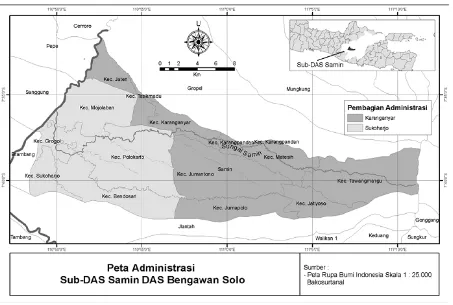
[image:3.595.74.527.262.567.2]Samin watershed is located in two districts namely Karanganyar and Sukoharjo, Central Java, Indonesia. Geographically, it extends from east to west. Its upstream area is on the slopes of Mount Lawu and downstream area is in Sukoharjo rice fields, covering a total area of 37,302.5 ha. The length of this watershed reaches 39.5 km and an average width 7 km. The areas of Samin watershed in the Karanganyar District include five sub-districts, namely: Tawangmangu, Matesih, Jumantono, Jumapolo, and Jatiyoso. On the other hand, the areas in Sukoharjo district include three sub-districts, namely: Bendosari, Mojolaban, and Polokarto (Fig 1).
Fig. 1 Map of Samin Watershed, Central Java, Indonesia (Sudaryanto 2010)
A research conducted by Prasetia (2015) showed the hydrological condition of Samin watershed. Land cover consist of dry secondary forest (638.5 ha), forest plantations (1550.9 ha), bush (309.9 ha), plantations (902.8 ha), bare land (3.0 ha), 3 dry land agriculture (8628.0 ha), dry land agriculture with bushes (9451.9 ha), and rice paddy field (3550.4 ha). The soil consists of association of grey alluvial and greyed brown alluvial (4339.0), association of dark grey grumosol and brown mediteran (4743.3 ha), reddish brown latosol (14 714.9 ha), and brown mediteran (3153.2 ha). Samin Sub Watershed could produce ground water flow of 311.0 mm/year (8.8%), percolation 452.0 mm/year (12.8%), lateral flow 4.3 mm/year (0.1%), surface runoff 2078.4 mm/year (58.7%), and evapotranspiration 697.3 mm/year (19.7%). River in sub watershed Samin will experience drought if there is no rain during the day and time of occurrence 50.75 more rain into the peak flow during the 19.825 days.
Tab. 1 Wide of degraded land of Samin watershed in every sub-districts of Karanganyar
Sub District Wide of Degraded Land (ha)
Jatiyoso 2468
Jumapolo 2732
Jumantono 2002.50
Matesih 313.75
Tawangmangu 717.14
3.
Composition of Vegetation in Samin Watershed
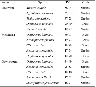
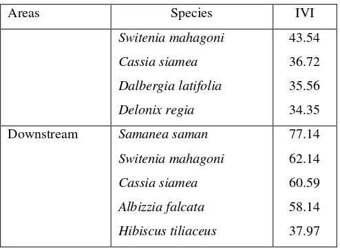
[image:4.595.143.455.326.611.2]Maridi et al (2014) had conducted a study on the composition of vegetation in Samin watershed, and the results showed the list of LCC species and tree species in upstream, midstream, and downstream area of Samin watershed. Five LCC species with the highest Important Value Index (IVI) are shown in Table 2. Meanwhile, the five tree species with the highest IVI are shown in Table 3.
Tab. 2 LCC species with highest IVI found in Samin watershed (Maridi et al, 2014)
Areas Species IVI Kinds
Upstream Mimosa pudica Ageratum conyzoides Tridax procumbens Digitaria sanguinalis Euphorbia hirta 56.24 45.34 37.23 20.40 19.22 Shrubs Shrubs Shrubs Grass Shrubs
Midstream Oplismenus burmanii Axonopus compressus Chloris barbata Ageratum conyzoides Digitaria sanguinalis 39.01 19.73 18.49 17.74 12.70 Grass Grass Grass Shrubs Grass
Downstream Oplismenus burmanii Ageratum conyzoides Chloris barbata Peperomia pellucida Stachytarpeta jamaicensis 34.49 26.53 18.10 17.91 16.77 Grass Shrubs Grass Shrubs Shrubs
Tab. 3 Tree species with highest IVI found in Samin watershed (Maridi et al, 2014)
Areas Species IVI
Upstream Tectona grandis Delonix regia Switenia mahagoni Dalbergia latifolia Cassia siamea 78.57 59.74 38.16 26.65 21.79
Areas Species IVI
Switenia mahagoni Cassia siamea Dalbergia latifolia Delonix regia
43.54
36.72
35.56
34.35
Downstream Samanea saman Switenia mahagoni Cassia siamea Albizzia falcata Hibiscus tiliaceus
77.14
62.14
60.59
58.14
37.97
4.
Potential Vegetation in Samin Watershed for Water and Soil Conservation
[image:5.595.175.422.68.249.2]Lower Crop Community (LCC)
Table 2 shows several LCC plants with highest IVI. These plants could be classified according to the kinds of plants into grass and shrubs. The grass species are Digitaria sanguinalis, Oplismenus
burmanii, Axonopus compressus, and Chloris barbata. Meanwhile, the shrubs species are Mimosa
pudica, Ageratum conyzoides, Tridax procumbens, Euphorbia hirta, Pepperomia pellucida, and
Stachytarpeta jamaicensis. LCC plants can potentially reduce runoff and increase infiltration.
Sumarno (2010) stated that the use of LCC plants is mainly to prevent erosion and reduce runoff. Furthermore, Li et al (2004) noted that the cover of LCC vegetation in the surface of soil can cause the accumulation of organic matter and soil micro climate modification that can stimulate microbial activity and form stable aggregates of ground water. One of the consequences of changes in the existing soil and aggregate is the effect on the improvement of infiltration mechanism.
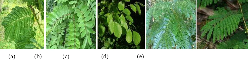
[image:5.595.124.479.436.530.2]
(a) (b) (c) (d)
Fig. 2 LCC species found in Samin watershed with the highest IVI: (a) Digitaria sanguinalis; (b) Oplismenus burmanii; (c) Axonopus compressus; and (d) Chloris barbata
Hoorman’s (2009) research result stated that the advantages of using cover crops community are: (1) reducing soil erosion and increase residue cover; (2) increasing water infiltration; (3) increasing soil organic carbon; (4) improving soil physical properties or reducing soil compaction; (5) recycling nutrients (especially fixing nitrogen with legumes); (6) improving weed control; and (7) enhancing the aesthetics of wildlife habitat and landscape. Research conducted by Saputra (2014) explained that the highest percentage retention of infiltration dominated growth form plot of grass and herbs; that was 87% of water is splashed. Meanwhile, the shrubs growth form also has high percentage of retention infiltration, which was 74%. Growth form plot on grass, herbaceous, and shrubs species was dominated by Axonopus compressus, Digitaria spp., Ruellia tuberosa, and Stachytarpeta jamaicensis. This means that the species has the potential to inhibit runoff and increase infiltration of rainwater, and also can reduce soil erosion.
Tree
restraint – root systems physically bind or restrain soil particles while above – ground residues filter sediment out of runoff; (3) retardation – above ground residues increase surface roughness and slows permeability; (4) infiltration – roots and plant residues help maintain soil porosity and permeability; and (5) transpiration – depletion of soil moisture by plants delays on set of saturation and runoff.
Maridi et al (2014) stated that tree canopy can retain rain water through several mechanisms. Vegetation canopy can intercept droplets of rain water that falls on it, hold it above the canopy, and release it over the surface of the soil (through fall) and let it run it through a carrier vessels in the stem (stem flow) as well as reducing its kinetic energy when it falls on the ground. This reduces the direct blow of rain water on the ground, thereby reducing the risk of damage to the soil surface, lowering erosion rate. Trees produce a litter layer, which can also reduce the negative effects of the rain drop, curb runoff, increase infiltration and reduce friction with the ground; thus, erosion and sedimentation are reduced.
The results of vegetation analysis showed that the dominant tree species in the upstream and midstream areas was Tectona grandis and in the downstream area was Samanea saman. These trees have large and strong root system as indicated by the height of plants and the canopy area. In the upstream, midstream, and downstream regions, the canopy area ranged from 31 to 430 m2 , 102-470
m2, and 79-320 m2, respectively Whereas, the height of plants ranged from 5.50 to 15.50 m,
3.38-11.25 m, and 3.50- 9.21 m respectively. Day et al. (2010) stated that size and spread of roots are influenced by the plant’s height and canopy area. Trees with large root serve to strengthen the soil, to prevent erosion and to hold a large amount of water. Litter layer also has the potential to enrich the soil to prevent the soil from turning barren. Having these conditions, the watershed is expected to remain in good condition characterized by a small erosion and sediment, because the rain water is infiltrated and stored mostly as ground water. This also has the potential to cope with droughts and flooding in the Samin watershed.
Morphological characteristics of tree plants in Samin watershed that potentially have a role in water and soil conservation in this watershed will be explained in this section.
1) Leaves
Leaves also have an influence in hydrological cycle, namely in interception and transpiration. Interception is amount of water being held up by canopy of vegetation (Lambrano et al, 2013; Yulianur et al, 2012; Xiao et al, 2000). Interception is an important process in hydrological cycle because it can determine water sustainability (Jong & Jetten, 2007). Interception is influenced by the architecture of canopy such as leaf area index, leaves distribution, and leaves characteristics. Characteristics of leaves also influence rate of transpiration.
The result of vegetation analysis provides the list of tree plants with different characteristics of leaves.
Delonix regia, Cassia siamea, Dalbergia latifolia, Samanea saman, and Albizzia falcata are species
from Fabaceae family. Their leaves are stipulating, nearly always alternating, and ranging from pinnately or palmately compound to simple. Judging from the leaf blade, these species have small interception. However, their compound leaves arrangement has the number of leaf blade and forming a large canopy that makes high interception.
[image:6.595.84.515.607.712.2](a) (b) (c) (d) (e)
Teak (Tectona grandis) is a tree species from Lamiaceae family. This species has large leaves with oval shape upside down, face to face, with a short stalk. Relatively large teak leaf blade is found on the young leaves with an average length of 60-70 cm and a width of 80-100 cm, while the older trees have an average length of 15 cm and a width of 20 cm. The leaf surface has a silky fur and hair glands on the bottom surface (Orwa, et al, 2009). The size of the leaf blade is very large and has coarse leaf surface (scaber) resulted in teak leaves capable of holding rainwater big enough for a large leaf blade, but teak canopy plants is not wide as growth tends to soar upward; thus, the interception is less than the maximum. Teak coarse leaf surface can collect rain water for a long time and will evaporate into the atmosphere. Teak leaf transpiration has great experience, because there is no coating to inhibit transpiration. It is also characterized by the fall of teak leaves in dry season to ensure water balance in the trunk of teak plants. Therefore, teak is considered less suitable to support water conservation in watershed due to the vast canopy of small and large water transpiration, although teak has a high economic value.
Accordingly, in addition to the morphological characteristics of the leaves of each species, canopy is also a big influence on the process of interception and transpiration. Large canopy area will have great impact on the process of interception of rainwater (Pudjiharta 2008 and Xu, et al., 2013). The large size of canopy can also create a microclimate around the tree (Arx, et.al, 2013); therefore, the temperature and humidity under the auspices of the canopy remains stable. This can lead to reduced evaporation of water in the soil so that the quality of soil does not decrease. In addition, the micro-climate created by the plant canopy will affect the fertility of the soil and accelerate weathering litter. The statement was supported by a research conducted by Arx, et al. (2013) that can create a vegetation canopy microclimate influencing various processes in forest ecosystems including the availability of nutrients in the soil and litter weathering.
The wide canopy of plants is affected by the stature of each plant species. Plant stature can be seen from the type of rod, the direction of growing stems and branches on the trunk. In addition, it can also be learned from the texture / surface of the stem on each species.
2) Stem
Based on the analysis of vegetation, all species have acquired the type of woody stems (lignosus) and the direction perpendicular to grow stem (Homo). This is because the species analyzed are tree vegetation, which has a woody plant requirements and have a minimum trunk diameter of 4 cm or with a circumference of at least 12.5 cm (Mitchell, 2010). They are woody stems of trees that would be more robust to grow upright and able to support the canopy/canopy above. In addition, the size of the rod in terms of diameter of the tree trunk is also influential in strengthening and supporting the canopy; the larger the tree trunks size is, the stronger it will be. The size of tree trunks also greatly affects the flow of the rod (steam flow). Therefore, the stem is influential in rainwater and flow interception rod in order to prevent direct flow of rain water to the ground.
3) Root System
The root system of a plant species has a distinctive shape, even though the environmental conditions such as soil properties and the amount of water available greatly affects both the shape of the root system and how far the roots develop. Root develops directly from the axis of the embryo called primary roots, and roots that grow from the roots of the so-called primary lateral roots. Root system structure varies in accordance with the relative development of primary roots and lateral roots. Root system basically has two main types, namely, the system taproot and root fibers. Generally, the system of taproot plants is found on dicot members (Dicotyledonae) and root fibers plant is found on the members of monocots (Monocotyledonae).
cells that are located near the protoxylem poles. The radial growth of dicot tree roots activity is generated by the secondary lateral meristem (cambium). This process can affect the root function as an increase in root hydraulic conductivity, mechanical strength, as well as the binding capacity and water storage.
5.
Conclusion
The results of this research show that there are several plants with the highest Important Value Index (IVI) and that can be developed for vegetative soil and water conservation. In tree vegetation, there are
Tectona grandis, Delonix regia, Switenia mahagoni, Cassia siamea, and Samanea saman. These tree
plants have big canopy that can retain rain water through several mechanism such as interception, reducing direct flow, and producing litter layer. In LCC vegetation, there are Mimosa pudica,
Ageratum conyzoides, Tridax procumbens, Oplismenus burmanii, Chloris barbata, and Axonopus
compressus. Grass vegetation could withstand runoff and increase infiltration.
References
[1] G. V. Arx, E. G. Pannatier, A. Thimonier, and M. Rebeiez. Microclimate in Forests with Varying Leaf Area Index and Soil Moisture: Potential Implications for Seedling Estabilish-ment in a Changing Climate. Journal of Ecology. 1-14, 2013.
[2] BPDAS. Circular Letter Number SE.02/V-SET/2009 about Decision in Working Area of BPDAS, 2009. [Indonesian]
[3] SD. Day, PE. Wiseman, SB. Dickinson, JR. Harris. Contemporary concepts of root system architecture of urban trees. Arboricult Urb For. 36(4): 149-159, 2010.
[4] DH. Gray, and AT. Leiser. Biotechnical Slope Protection and Erosion Control. Van Nostrand Reinhold Company. New York. 1982.
[5] A. Hodge, G. Berta, C. Doussan, F. Merchan, and M. Crespi. Plant root growth, architecture, and function. Plant Soil 321: 153-187, 2009.
[6] JJ. Hoorman. Using Cover Crops to Improve Soil and Water Quality. Ohio State University. 2009.
[7] P. Li, Z. Li, and K. Lu. Effect of Vegetation Cover Types on Soil Infiltration Process Under Simulating Rainfall. International Soil Conservation Organization Conference. 601: 1-4, 2014.
[8] M. Maridi. Identification of Vegetation Diversity for Keeping Quality of Slope in Dengkeng Watershed. Independent Research Report. Sebelas Maret University, Surakarta, 2013.
[9] M. Maridi, S. Alanindra, A. Putri. Identification of Vegetation Diversity for Keeping the Quality of Slope Around Dengkeng Watershed in Klaten Central Java. Proceeding of the 4th Annual Basic
Science International Conference 2014 in Conjuction with the 5th International Conference on
Global Resource Conservation. 2014.
[10] Maridi, S. Alanindra, A. Putri. Vegetation Analysis of Samin Watershed, Central Java as Water and Soil Conservation Efforts. Biodiversitas Journals of Biological Diversity. 15(2): 215-223. 2014.
[11] E. Menashe. Vegetation and Erosion a Literature Survey. Environmental Education Assessment
and Management. Greenbelt Consulting, Clinton, 2005.
[12] K. Mitchell. Quantitative Analysis by the Point-Centered Quarter Method.
(http://arXiv:1010.3303.q-bio.QM), 2010. Diakses tanggal 15 Mei 2014
[13] C. Orwa, A. Mutua, R. Kindt, R. Jamnadass, and A. Simons. Agroforestree Database: a tree
reference and selection guide version 4.0. (http://www.worldagroforestry.org/af). 2009. Diakses
tanggal 19 Mei 2014
[15] DA. Prasetia. Hydrology Analysis at Samin Sub Watershed Used SWAT Model. Faculty of Forestry Bogor Agricultural Institute. 2015.[Indonesian]
[16] A.Pudjiharta. Pengaruh Pengelolaan Hutan pada Hidrologi. Jurnal Info Hutan (2):141-150, 2008.
[17] A. Rangkisani, L. W. Santosa, dan R. P. Sancayaningsih. Analisis Vegetasi pada Berbagai Kondisi Mata air di Bagian Utara dan Tengah Kabupaten Gunungkidul Provinsi Daerah Istimewa Yogyakarta. Tesis. Program Studi Ilmu Lingkungan Jurusan Antar Bidang Sekolah Pascasarjana UGM. Yogyakarta, 2012.
[18] HD. Riyanto, and Paimin. Performance of hardwood tree in Samin watershed in the perspective
of watershed conservation. For Nat Conserv Res J, 8(1):45-54, 2011. [Indonesian]
[19] S. Sudaryanto. The Analysis of Agricultural Land Use in Protected Areas Watershed Samin for Landslide and Flood Disaster Mitigation. Journal of Soil Science and Agroclimatology. 7(1): 41-50, 2010. [Indonesian]
[20] Sumarno. Vegetation for Soil and Water Conservation. (smno.pdsl.pdkl.ppsub.20-13), accessed at May 28th 2014, 2010. [Indonesian]
[21] R.A P.R Thakare, Jadhav, S.K. Hastimal. Watershed Management-A Case Study of Satara Tanda Village. International Journal of Innovative Technology and Exploring Engineering (IJITEE), 3(3):2278-3075, 2013.
[22] J. Triwanto. Forest Land and Watershed Conservation. UMM Press, Malang, 2012. [Indonesian]
[23] Z. Xu, Z. Feng, C. Zhao, J. Zheng, J. Yang, F. Tian, H. Peng, C. Wang, S. Peng, and H. Sher. The canopy rainfall interception in actual and potential distribution of Qinghai spruce (Picea