E-ISSN: 2347-5129 Showroom (1st Floor), Victoria
Road, Tangail-1900, Bangladesh
Coastal zone of Khulna district in Bangladesh:
Fisheries land use and its potentials
Md. Abul Kashem, Abdullah Al Mamun Siddiqui and Md. Mahbubur
Rahman
Abstract
Khulna district was established in 1882. It is situated between 22°12′ and 23°59′ north latitudes and
between 89°14′ and 89°45′ east longitudes. The district is bounded on the north by Jessore and Narail
districts, on the east by Bagerhat district, on the south by the Bay of Bengal and on the west by Satkhira
district. In respect of area, it ranks 1st among the 10 districts in Khulna division and 4th among the 64
districts of the country.
Land use in coastal Bangladesh is diverse, competitive and conflicting. Agriculture, shrimp farming, salt production, forestry, ship-breaking yards, ports, industry, settlements and wetlands are some of the uses. Land uses have gone through major changes. Land use in the 1950s had been mainly for paddy cultiva-tion, but salinity intrusion and tidal flooding prevented further intensification.
The detailed fisheries study has been carried out up to union level to collect all kinds of relevant data, maps, reports and information from field survey using proper tools and techniques. The relevant secondary data on fisheries land uses, satellite image classification and information pertinent to present status of fisheries had also been collected from Department of Fisheries (DoF), BBS and SPARSO suitability and assign it to one or a few specific uses for which the land will technically most suitable and economically viable. To determine present fisheries land use situation detailed experiment study has been conducted through PRA tools like Key Informant Interview (KII) with the related fish farmer, local people and little coordination of Government officials.
Satellite images were used to identify water bodies of the Khulna District. Upazila wise fisheries land use maps have been prepared interpreting the satellite image. This Upazila wise map was validated and Khulna district fisheries land use map was finalized by ground truthing and discussion at experiment work.
Keywords: Land use, aquaculture, shrimp farming, Land Zoning
Introduction
The fisheries of Khulna district consist of inland open water fisheries and fresh water aquaculture. Like other parts fisheries sector of the country, particularly fisheries of Khulna district is a major source of nutrition, income, employment and livelihood support of the local people.
In Bangladesh, fish provides 60 percent of the national animal protein and this sub-sector contributes about 5 percent to the GDP and approximately 9 percent to the total foreign exchange earnings. Nearly, 1.2 million people directly employed in this sub-sector and another 11 million are indirectly engaged in activities related to this sector (Fisheries Statistical Report of Bangladesh (July 2014 - June 2015).
~ 600 ~
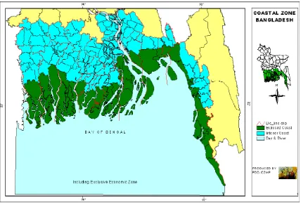
The continuing decline in capture fish stocks and production resulting from the factors such as over-fishing, siltation of beels and other water bodies, and the impacts of Flood Control and Drainage (FCD) Projects and other infrastructural activities are very alarming for fish resources. The survival (including sustainable management, where appropriate) of ecologically sensitive wetlands and forest areas is also a burning issue which needs due importance for maintaining our rich ecosystem of the country. Land uses in coastal Bangladesh (Fig. 1.1) have gone through major changes over the last half century. The land is intensively used for agriculture, settlements, forests, shrimp ponds (known locally
as ghers), water bodies and fisheries, salt production,
industrial and infrastructure developments, tourism and preservation and management of environmentally important and special areas. With the continually increasing population, the following features emerge.
Government of the Peoples Republic of Bangladesh, Ministry of Land, field survey 2006-2012 and BBS 2012-2013, SPARRSO 2012-2013, Table 1.2). The study area was selected on the basis of the following criteria: (1) the area should have extensive shrimp and fish culture; (ii) the change in the physical environment should be homogeneous and representative of the situation in the coastal areas; (iii) Fish and shrimp should be the main crop and provide the major share of income of the farmers of the area and (iv) Present
status of agriculture and urban land.
The detailed fisheries study has been carried out up to union level to collect all kinds of relevant data, maps, reports and information from field survey using proper tools and techniques. The relevant secondary data on fisheries land uses, satellite image classification and information pertinent to present status of fisheries had also been collected from
Department of Fisheries (DoF-2013) [14] and SPARRSO
(2012-2013) respectively to develop a data bank for classifying land and water bodies on the basis of fisheries land suitability and assign it to one or a few specific uses for which the land will technically most suitable and economically viable. To determine present fisheries land use situation detailed study has been conducted through PRA tools like Key Informant Interview (KII) with the related fish farmer, local people and government officials.
Information was collected from upazila different government office and respondents belonging to five landowner categories using land-use survey and questionnaire survey techniques. Field observation based on the perception of local people was carried out and recorded documents of relevant studies were examined. Information relating to the landscape ecology in the past was collected with Retrospective Inquiry System (RIS) techniques and ground truthing was performed with the help of aerial photography and satellite images.
Fig 1.1: The coastal zone of Bangladesh. Source: Islam et al., 2006
Approach and Methodology
The study was conducted in 9 selected upazila Batiaghata, Dacope, Dighalia, Dumuria, Koyra, Paikgachha, Phultala, Rupsa and Terokhada of Khulna District. Khulna District covers 432300 hectare (Table 1.2) of land and is located in the centre of the western region of the coastal zone. It is situated on the Mongla River and is well connected to the Passur River. The area of dacopeupazila of Khulna district close to the Sundarbans mangrove forest and covers 724.16 hectare
shrimp should be the main crop and provide the major share of income of the farmers of the area and (iv) Present status of agriculture and urban land.
The detailed fisheries study has been carried out up to union level to collect all kinds of relevant data, maps, reports and information from field survey using proper tools and techniques. The relevant secondary data on fisheries land uses, satellite image classification and information pertinent to present status of fisheries had also been collected from
Department of Fisheries (DoF-2013) [14] and SPARRSO
(2012-2013) respectively to develop a data bank for classifying land and water bodies on the basis of fisheries land suitability and assign it to one or a few specific uses for which the land will technically most suitable and economically viable. To determine present fisheries land use situation detailed study has been conducted through PRA tools like Key Informant Interview (KII) with the related fish farmer, local people and government officials.
Information was collected from upazila different government office and respondents belonging to five landowner categories using land-use survey and questionnaire survey techniques. Field observation based on the perception of local people was carried out and recorded documents of relevant studies were examined. Information relating to the landscape ecology in the past was collected with Retrospective Inquiry System (RIS) techniques and ground truthing was performed with the help of aerial photography and satellite images.
Objectives of the Study
The main objectives of the study are:
to develop and assessment of capture and culture
fisheries area and their current status;
to demarcate the suitable areas for both capture and
A statistics of present wetland area used by fresh water
capture and culture fisheries.
Land zoning implications on fisheries.
Fisheries land use map of Khulna District. History of fisheries land use in Khulna district
The Bangladesh coastal zone (Fig. 1.1) is a significant maritime habitat of ecologically rich and economically important natural resources. The area is situated along the largest river system running below the Himalayan Mountains. In this zone, the rivers discharge an enormous quantity of fresh water and maintain a level of salinity both on land and in sea that favours the rapid growth of a wide variety of vegetation and aquatic life. The coastal region, especially the southwestern portion Khulna district is one of the most promising areas for shrimp cultivation for two major reasons (MOFL, 1997; Karim and Shah, 2001) [6, 5]: First, its fresh-
and saltwater resources are abundant in almost all seasons; second, the world’s largest continuous mangrove forest, the Sundarbans, provides a food source and nursery for the offshore fishery.
It is estimated that about 250,000 ha of land has good potential for coastal aquaculture (Ahmed, 1995) [7]. About
180,000 ha is suitable for shrimp culture (Khan and Hossain,
1996). Coastal aquaculture increased from 20,000 ha in 1994/1995 to 135,000 ha in 1996/1997, and production from 4000 to 35,000 metric tons in the same period (MOFL, 1997)
[6]. The rapid expansion of shrimp farm development during
the last decade, along with the adoption of extensive and improved extensive culture techniques, has caused growing concern as to its adverse effect on the coastal environment and damage to the traditional agricultural systems. The socio-economic scenarios have changed rapidly.
This chapter aims to assess the effects of the past and current situation as regards shrimp cultivation methods in relation to the coastal environment. In particular, the research aims to identify the inherent potentials and problems, as well as the emerging trends in the causes and extent of land-use changes over a period of time, with a view to understanding the implications for land-use planning and the development of more environmentally acceptable shrimp cultivation methods. How mangrove forests work as sinks of high potential for aquaculture that were not recognized in the resource-assessment process. Exclusion of these lands from an aquaculture zone could prevent appropriate development, subject it to inappropriate regulation or restrict access of poor people to opportunities for aquaculture development. Furthermore, zoning may actually be undesirable for encouraging a concentration of aquaculture because of the associated environmental and social impacts.
Environmental capacity measures the resilience of the natural environment in the face of impact from human activities. Some assessment of environmental capacity is desirable and is of particular relevance to the problem of cumulative effects. It has been argued (GESAMP, 2001) [9] that environmental
capacity must be assessed, even if only at the most elementary level, if sustainable development is to have any practical meaning. Environmental capacity (otherwise referred to as assimilative capacity) is ‘a property of the environment and its ability to accommodate a particular activity or rate of an activity without unacceptable impact’ and must be measured against some established standard of environmental quality. A set of planning interventions in the form of incentives and constraints (planning regulations) will be required to implement the strategy and ensure that objectives are met, standards are not breached and environmental capacity is not exceeded. These might apply to location of aquaculture development, waste emissions and the quantity or quality of inputs used (e.g. food, chemicals).
Land use of Khulna District
Land use in Bangladesh is generally determined by physiography, climate and land height in relation to water level (Brammer, 2002) [10]. These together make a highly
~ 602 ~
Land is the basic natural resource that provides habitat and sustenance for living organisms, as well as being a major focus of economic and livelihood activities. Bangladesh has a population of 123 million living on a land area of 147,000
In the coastal zone also, the population is expected to increase from 36.8 million in 2001 to 43.9 in 2015, and to 60.8 million by 2050 (PDO-ICZMP, 2005a). Present per capita agricultural land of 0.056 ha will decrease to 0.025 ha by 2050. On top of this, about 54% of the people of coastal Bangladesh are functionally landless and more than 30% are absolutely landless. Among the landholders, 80% are small farmers, 18% are medium farmers and only 2% are large farmers
(PDO-ICZMP, 2004b) [11]. These have decisive impacts on major
economic and livelihood activities, on land use and subsequently on the quality of land.
In 2010- 2011, an estimate was made (Table1.2) capturing a broader perception of land use and recognizing seasonal
variations (Source: SPARRSO 2012-2013, Field survey 2006-
2012). Two complications were identified: areas under river
and water bodies increased greatly in the wet season and
estuarine/riverine wetlands (known locally as chars)
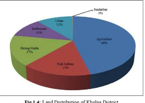
cultivated during the dry season went under water in the wet season. In Khulna District, agriculture, shrimp farming, salt production, forestry, ship-breaking yards, ports, industry, human habitation and wetlands are some of the uses in an area of only 432300 hectare inhabited by 36.8 million people. Land use in the coastal zone is diverse, competitive and conflicting.
Table 1.2: Upazila Wise Land Distribution of Khulna District (Area in hectare)
Upazila Name Upazila Area (ha) Agriculture Fish Culture Shrimp/Galda Settlement Urban Sundarban
Batiaghata 24800 11839.52 4034.96 2599.04 3159.52 3159.52 0
Dighalia 7700 3952.41 766.92 613.69 1182.72 1182.72 0
Dumuria 45400 19739.92 6165.32 9070.92 5202.84 5202.84 0
Koyra 177500 76413.75 29447.25 35216 18193.75 18193.75 0
Dacope 99200 58230.4 14949.44 4612.8 10326.72 10326.72 724.16
Paikgachha 41100 15675.54 4825.14 12194.37 4196.31 4196.31 0
Phultala 5700 2240.67 119.13 800.85 1268.82 1268.82 0
Rupsa 12000 5614.8 534 1375.2 2236.8 2236.8 0
Terokhada 18900 5762.61 5000.94 4980.15 1576.26 1576.26 0
Total 432300 199469.62 65843.1 71463.02 47343.74 47343.74 724.16
Source: SPARRSO (2012- 2013), BBS (2012-2013), Field Survey (2006-2012)
Fig 1.4: Land Distribution of Khulna District
Present Fisheries Status of Khulna District
Fisheries of Khulna district have immense prospects and scope of development to strengthen the rural economy. The basic mechanism of capture fisheries at Khulna has been allocation of fishing rights through periodic leasing and affordable modern aquaculture techniques has been practiced. Fisheries resources of Khulna considering rivers, estuaries, flood plains, beels, lakes and ponds which are the most
important sources of livelihood and food supply for the rural poor.
Wetlands are the most important sources of livelihood and food supply for the rural poor. Wetlands are being threatened by man-made problems and natural calamities. Fisheries sector contributes 4.39% to the national GDP and 22.76% to the total agricultural GDP (Bangladesh Economic Review 2012). About 2.5% the total of country export earning comes from the fisheries sector (2011-2012) and it ranks 3rd among the export oriented industries. Fish supplements to about 60% of our daily animal protein intake and about 11% of the population depends directly and indirectly on the fisheries for their livelihood (DoF, 2013) [14]. Total fish production was
gradually grown up during the last 10 years. The production in 2002- 2003 was 21.21 lakh MT, where as it increased up to 34.10 lakh MT in 2011-12 (Fisheries Statistical Year Book of Bangladesh 2012-2013).
The average fish production of Khulna district capture fisheries are 350 kg/ha and culture fisheries (pond aquaculture) are 2100 kg/ ha in 2012-13. Total areas of capture (Shrimp/Galda) and culture fisheries are 71463.02 hectare and 65843.10 ha respectively (Source: GIS data from
Fig 1.2. Fisheries Production of last 10 years in Bangladesh
Impact of Land use and land zoning Over Fisheries in Khulna District
Zoning is a tool, which defines the demarcation of geographic areas with specific combinations of properties or features. The kind of features, which are chosen and the interpretation of their different combinations depend on the purpose of the zoning exercise. Zoning is most often used for properly maintenance of bio-diversity in the area for research and planning purposes.
Regarding fisheries in Khulna District, land zoning can help for protection of fish habitat, nursery areas, and as well as habitat restoration of the fisheries ecosystem. It does not usually address fisheries operations such as controls on harvesting (e.g., sizes, seasons, gear type etc).Land zoning can also support fisheries management, overfishing problems and multiple resources use conflicts in this upazila.
The emerging concept is to formulate land zoning, with administrative boundaries as the unit, in accordance with the (dominant) land use and economic activities, as well as their potentials and vulnerabilities. Hence, this zoning has to be more than just a description of the current situation and must account for major underlying ecological and socio-economic factors and processes that have led to the current situation and
that may be important for future trends and hazards. The approach should therefore take into account important ecological and socioeconomic factor (Table 1.2 and figure 1.3).
Zoning as a tool for area development is, of course, an ambitious goal that can only be attained in stages. Mutsaers and Miah (2004) have outlined the following conceptual basis for the first stage in the process to delineate an indicative coastal land zoning:
Use of an administrative boundary2 as the unit for zoning,
such as the upazila as the unit for indicative land zoning. Further detailed versions using union and later field blocks will be developed; use of only existing data. Field informa-tion to be collected for the purpose of validating the zoning (ground-truthing);
proactive interaction with relevant agencies at different stages of the elaboration process; and
Support and backing of a structured technical support group involving government and non-government agencies. The Ministry of Land will be involved as an implementing agency of the Land-Use Policy.
(Source: Table 1.2, SPARRSO 2013-2014, Field survey 2006-2011)
~ 604 ~
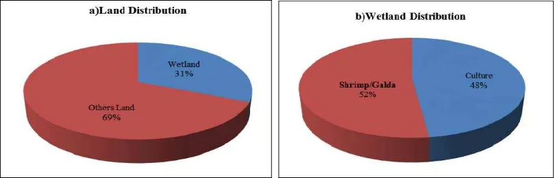
Fisheries Land Use Distribution of Khulna District Khulna District has a total wetland area of 137306.12 hectare of which 65843.10 hectare is under fish cultureand71463.02 hectare is Shrimp/Galda culture. Upazila wise Land distribution including wetland and others land has been shown
below (Table 1). Terokhada, Paikgachha, Koyra and Dumuria upazila shows good potential for fisheries production of Khulna District which covers 52.81%, 41.41%, 36.42% and 33.46% of total wetland respectively.
Table 1: Wetland Distribution of Khulna District (Hectare)
Upazila Name Upazila Area (ha) Fish Culture Shrimp/Galda Total Wetland
Batiaghata 24800 4034.96 2599.04 6634 (26.75%)
Dighalia 7700 766.92 613.69 1380.61 (17.93%)
Dumuria 45400 6165.32 9070.92 15236.24 (33.56%)
Koyra 177500 29447.25 35216 64663.25 (36.42%)
Upazila Name Upazila Area (ha) Fish Culture Shrimp/Galda Total Wetland
Dacope 99200 14949.44 4612.8 19562.24 (19.72%)
Paikgachha 41100 4825.14 12194.37 17019.51 (41.41%)
Phultala 5700 119.13 800.85 919.98 (16.14%)
Rupsa 12000 534 1375.2 1909.2 (15.91%)
Terokhada 18900 5000.94 4980.15 9981.09 (52.81%)
Total 432300 65843.10 71463.02 137306.12 (31.76%)
Source: BBS (2012-13), Field Survey (2006-2012) and SPARRSO (2012-2013)
Out of total area of 432300 hectare only 31.76% represents wetland which covers 48% culture and 52% capture (shrimp/Galda) fisheries respectively (Figure 1). Generally it varies in dry and wet season. When dry season, situation of
water level is alarming and progressive river siltation occur as a result reduce water holding capacity. On the other hand, these water bodies are also dried up quickly in the dry season.
Fig 1: a) Distribution of Land b) Distribution of Capture and Culture Fisheries in Wetland of Khulna District
Open Water Capture Fisheries of Khulna District
Khulna District has potential of inland open water fisheries resources that consist of the seasonal water bodies, rivers, baors, natural depressions or beels and reservoir. There are about 25,000 fisheries beneficiaries involve in fisheries activities of the Khulna District. Present field survey shows that annual flooding in the rainy season inundates up to10-25% of the total land surface. Despite the existence of huge resources the inland capture fisheries have been replaced as top fish producing sources over the years by aquaculture due to decline and degradation of resources. But, over a few years, aquatic biodiversity especially fish species and other aquatic organism in inland open water have been declined due to
natural and anthropological causes. The priority is given to improved biological management that will restrict the degradation of resources and production. Major native capture species are: aor (Sperataaor), taki (Channa punctatus),
kholisha (Colisa sp.),Shrimp (Peneaus monodon), Galda
(Macrobrachium rossenbergi), shoal (Chana striatus), chanda
(Chanda ranga), koi (Anabas testudineus), magur (Clarias
batrachus), tengra (Mystus tengra), foli (Notpterus notpterus),
baim (Mastacembalus spp.), raina (Nandus nandus), chapila
(Gudusia chapra), mola (Amblyphayngodon mola),puti
(Puntius puntio), boal (W. atto), rui (Labeo rohita), catla
(Gibelion catla) etc.
Closed Water Culture Fisheries in Khulna District Fresh water aquaculture is an important component of Khulna District fisheries. The culture fisheries of Khulna District include ponds, nursery, etc and rice fields, canals and small beels (natural depression) are also gradually coming under culture-based capture fisheries practice. The seasonal water bodies, aquaculture pond and the beels offering tremendous scope and potential for augmenting fish production by adopting aquaculture based enhancement techniques in Khulna District. It is expected that with the introduction of scientific method of fish culture, the present production will
be increased substantially. Currently aquaculture has been practicing in a total area of about 670.62 ha which cover about 65.28% of total inland water of Khulna Distric (Table1, Figure 1). Culture fisheries comprises of baor and pond aquaculture, fish culture in homestead pond and paddy field etc.
Major native culture species are: bata (Labeo bata), mirigal
(Cirrhina mrigala), tilapia (Orechromis nilotica), grass carp
(Ctenopharyngodon idealla), silver carp (Hypopthalmichthys
nobilis), pungus (Pungassius suchi), rui (Labeo rohita), catla
(Catla catla), Thai koi (Anabas testudineus) etc.
Fish Harvest in Aquaculture Pond Prawn Harvested From Gher
Fish Harvested from Gher Fish Harvested from Beel
Problems of Capture and Culture Fisheries in Khulna District
Indiscriminate use of destructive fishing gears like current jal (mono filament twin net).
The fish species diversity and stocks were under threats
of depletion due to indiscriminate and uncontrolled harvesting.
Indiscriminate harvesting of brood/mother fish during breeding season.
Municipal waste are creating serious water pollution and
hampering the growth of the aquatic flora and fauna etc.
The demand for agricultural production, particularly cereals, encourage attempts to dry out the wetland with a reduction in the capture area particularly beel and its fisheries resources.
Erratic rainfall, prolong flooding, six month dry season and sandy soil is a major problems for full time aquaculture practices.
Blockade of rivers and canals by flood protection
embankments has seriously affected natural abundance of fish in open water by disrupting breeding migration.
Inappropriate pond design and indecision on aquatic
resource use from multiple owners.
Poor quality fish seeds due to inbreeding depression in the private hatcheries results in poor growth of fish.
Lack of knowledge about stock enhancement, seed
production and improve culture technology and pond management system.
Perennial water bodies are reducing due to falling of existing ground water level and land conversion.
Suggested Measures for Development of Capture and Culture Fisheries in Khulna District
Use of destructive gears must be prohibited.
Current net must be stopped by creating a public
awareness.
Formulation of land zoning for fisheries areas and its implementation is an immediate necessity.
Provision for fish passes should be kept at vital points during construction of roads, sluice- gate, cross- dam and embankments etc.
Harvesting of brood/mother fish should be strictly
~ 606 ~
Transfer of wetland for other purposes/uses is to be strictly prohibited.
Before construction of embankment, road, culverts etc. its impacts on fisheries and other aquatic fauna and flora should be assessed properly.
Established fish sanctuary and beel nursery.
Intensive stocking of fingerlings with free of cost in open water bodies (river, canal, beel etc.) should be initiated by Department of Fisheries.
Credit facilities should be extended to small traders with minimum/marginal interest.
Demonstration of aquaculture technologies in the
farmer’s field at the District and upazila level through government level.
Introduction of certification methodology by the
authority to the hatchery owners that they are maintaining a standard protocol for spawning by using the proper sized broods.
The fisheries extension activities should be practiced like model village programme, fry traders programme, trial programme, school programme. Rice-fish programme should also be practiced in this region.
Leasing government ponds, lakes and other water bodies
to targeted poor or unemployed youth.
Involved poor fishermen in community based culture
fisheries development in beel, ghear and other potential water body
Indicative Land Zones and Fisheries Land use map in Khulna District
An indicative land zoning has emerged (Fig.2.2, PDO-ICZMP, 2005b), identifying the following eight zones:
shrimp (brackish-water) zone,
shrimp (sweet-water) zone,
salt–shrimp zone,
forest zone,
mangrove (including Sundarban) zone,
urban and commercial zone (industrial, port, export-processing zones and ship-breaking yards),
tourism zone, and
Agricultural zone.
Results of the indicative land zones have been presented to field-level stakeholders at regional workshops and to policy planners at national workshops. There is now a national consensus on indicative land zoning.
Conclusion
Khulna district is endowed with rich and vast fisheries resources. Due to favorable natural conditions and geographical location these fisheries resources have high potential of increasing fisheries production in this upazila. The coastal and estuarine areas of Bangladesh are covered by extensive mud flats, saline water, brackish water and protected bays. These places support huge numbers of important living resources, which are suitable for marine ranching. Local people indiscriminately utilize these natural resources and some are now completely destroyed, for example, the Sunderban mangrove forest in Khulna District. Most of the resources are being over-utilized (e.g. fish stock and shrimp fry) while some remain untouched or under-utilized (mollusks, seaweeds, crabs and offshore fishes). Therefore, sustainable practices, management and conservation of the estuarine and coastal resources and their related ecosystems are needed. Fisheries Sector of Khulna district can contribute to improve the socio-economic condition of the rural people. Fisheries land use of Khulna was analyzed using field survey, focus group discussion (FGD), government data and statistics and satellite image interpretation. The water bodies of the upazila are habitats of valuable fish and other aquatic organisms. This study has identified potential causes for this decline including habitat degradation due to siltation and conversion of wetland to agriculture, increasing fishing pressure, destructive fishing practices and an acute shortage of dry-season wetland habitats. Continued research on land use will support optimum, sustainable and environmentally friendly land use and the subsequent modern management of land use through land zoning. Setting the appropriate legislative framework is
fundamental to effective implementation of the land use and zoning policy. A number of laws are in operation since long author using surveillance and patrolling of the coastal and marine waters for the preservation of the natural environment and sustainable use of coastal resources.
This version of land zoning is expected to be used as a basis for detailed land zoning, as elaborated in the Land- Use Policy (MoL, 2001). The challenge is to give a legal status to this broad zoning. However, the strength of this exercise is that it has brought relevant agencies together on an institutional platform. A consensus has been reached to aim for further detailed land use and zoning, but taking one step at a time. Land zoning, complemented by policy and investment support, can be instrumental in managing diverse land uses in the coastal zone.
~ 608 ~
References
1. Study of Detailed Coastal Land Zoning with Two Pilot Districts of Plain Land Project under Government of the Peoples Republic of Bangladesh, Ministry of Land, field survey, 2006- 2012.
2. BBS (Bangladesh Bureau of Statistics) Statistical
Yearbook of Bangladesh. Statistical Division, Ministry of Planning, Dhaka, Bangladesh, 2012-2013.
3. Bangladesh Space Research and Remote Sensing
Organization (SPARRSO) data from 2012- 2013. 4. “Fishery statistical yearbook of Bangladesh Fisheries
Resources Survey System, Department of Fisheries (DoF). Dhaka. 2013, 2014.
5. Karim MR, Shah MS. Brackish Water Shrimp
Cultivation Restricts Coastal Agriculture. Khulna University Studies, Khulna, Bangladesh 2001; 2(1):123-134.
6. MOFL (Ministry of Fisheries and Livestock) Fisheries resources development and management. Paper presented at the National Workshop, 29 October to 1 November 1997, MOFL, Dhaka, Bangladesh, 1997.
7. Ahmed ATA. Impacts of shrimp culture on the coastal
environment of Bangladesh. In: Proceedings of the
National Workshop on Coastal Aquaculture and
Environmental Management. Institute of Marine
Sciences, 25–28 April 1995. Nuruddin Mahmood, University of Chittagong/UNESCO, Bangladesh, 1995, 77-84.
8. Khan YSA, Hossain MS. Impact of shrimp culture on the
coastal environment of Bangladesh. International Journal of Ecology and Environmental Sciences. 1996; 22(2):145-158.
9. GESAMP. Planning and Management for Sustainable
Coastal Aquaculture Development. IMO/FAO/
Enesco/WMO/WHO/IAEA/UN/UNEP Joint Group of Experts on the Scientific Aspects of Marine Pollution, Rome, 2001.
10. Brammer H. Land Use and Land Use Planning in
Bangladesh. The University Press Limited, Dhaka, Bangladesh, 2002, 554.
11. PDO-ICZMP (Program Development Office for
Integrated Coastal Zone Management Plan) Where Land Meets the Sea: A Profile of the Coastal Zone of Bangladesh. The University Press Limited, Dhaka, Bangladesh, 2004b, 317.
12. PDO-ICZMP (Program Development Office for
Integrated Coastal Zone Management Plan) Living in the Coast: Urbanization. PDO-ICZMP, Water Resources Planning Organisation, Dhaka, Bangladesh, 2005a, 36. 13. Islam MR. Where land meets the sea: a profile of the
coastal zone of Bangladesh (Ed). The University Press Limited, Dhaka, 2004, 317.