http://dx.doi.org/10.17503/Agrivita-2012-34-3-p251-261
DEVELOPMENT OF SUSTAINABLE CULTURAL LANDSCAPES
IN WEST KALIMANTAN
Karuniawan Puji Wicaksono 1,3*) and Nobukazu Nakagoshi 2)
1)
Faculty of Agriculture University of Brawijaya Jl. Veteran Malang 65145 East Java Indonesia.
2)
International Development and Cooperation (IDEC) University of Hiroshima, Japan Hiroshima University, IDEC, 1-5-1 Kagamiyama Higashi-Hiroshima-shi Hiroshima 739-8529 Japan
3)
South-South Cooperation Studies University of Brawijaya *) Corresponding author Phone: +62-341-551665 E-mail: karuniawan.fp@ub.ac.id
Received: January 12, 2012/ Accepted: September 29, 2012
ABSTRACT
This research focuses on investigating West Kalimantan’s traditional landscapes, shifting cultivation pattern, and comparing the forest dependency of several ethnic groups. After conducting remote sensing and geographical information system techniques based on the satellite images LANDSAT-TM in West Kalimantan from 1996 to 2006, the decrease of primary dry tropical forest from 36.4% to 15.9% and a little increase of agriculture land from 44.8% to 45.1% were detected. West Kalimantan’s traditional landscape is a combination of primary forest, shifting dry rice-field, rubber plantation, fruits garden and home garden, meanwhile new landscape managed by migrants mainly consist of permanent wet land rice-field, dry land rice, and crop fields. The decreasing forest area forces the native people to shorten the shifting cultivation cycle or to turn to permanent agriculture with the low yield. This situation is the result in the more primary forest clearing for agriculture usage by native people and migrants. It is clear that the traditional landscape of West Kalimantan is particularly dependent upon its most vital element, the forest. Yet, traditional landscape representing the regeneration cycle of forest in West Kali-mantan was constrained by changes in managed and modern landscape.
Keywords: landscape, forest, cultural, land-use, ethnics group
INTRODUCTION
Indonesia accounts for almost 60% of all forested lands in the Southeast Asian region and
additionally, it boasts greatest proportion of the remaining primary rainforest in this region. Forests are still the primary landscape of Indonesia, with nearly 75% of the land area managed under Indonesian department of forestry. This statistic makes Indonesia as the third largest tropical forested area in the world (after Brazil and Zaire) (Marjokorpi and Ruokolainen, 2003). Despite the rich biological diversity, Indonesia's forest eco-systems also support millions of indigenous people who have historically inhabited the forest interior. Perversely, a growing number of migrants from densely populated Java Island, along with logging of valuable tropical hardwoods and mining activity have contributed significantly to the lost of forest area, although the logging and mining activity provide strategic income to Indonesian economic acceleration.
Due to active timber utilization industry, mining, plantation activities, and migrant pressures, it is estimated that one-half of Indonesia's deforestation during the 1980s occurred in Kalimantan, mostly in West Kalimantan. Inspite of this, very little information is available about existing traditional community settlements and landscape. Most of those landscapes are owned without proper certification and title and it is estimated that only 20 percent of the traditional agriculture land has been titled. Meanwhile, the protection of traditional landscape and historical activities which occur in these areas, has not yet been initiated (Forestry Department of Indonesia, 2007).
Actual and realistic future land use changes in West Kalimantan are easily understood by looking at the trend of agriculture area growth in this province. Agriculture, the most common activity conducted by 85% of the West Kalimantan
population has grown rapidly, which consequently increases the area of arable land. Per contra, this expansion does not correlate with increased productivity due to unfertile soil and poor manage-ment. The increase in agriculture area is facilitated mostly by improvement of infra structure, commu-nication, transport facilities and sponsored trans-migration program which moves people from the densely populated Java Island to the sparsely populated land of West Kalimantan. Nevertheless, agriculture development without sufficient techno-logy to sustain the production and soil fertility may induce more pressure to the remaining forests (de Jong, 1997)
The objectives of this study are to determine the land-use changes of West Kalimantan Province from 1996 to 2006 and to determine the difference between the traditional native landscape and migrant landscape and in turn their appre-ciation to forest functions.
MATERIALS AND METHODS
Research Area
West Kalimantan Province is located in western part of Kalimantan Island. Geographically, West Kalimantan is located between 2º8' N to 3º5' S and 108º30' E to 114º10'. Based on this specific geographical position, West Kalimantan including Pontianak City (the capital of West Kalimantan Province) lies exactly on the equator line (latitude 00). Considering the condition, West Kalimantan is categorized into tropic region with relatively hot and humid climate condition (Indonesian Statistic, 2005).
The area of West Kalimantan is about 14.68 million ha (146,800 km2) with most of the land located in the low altitude. Compared with the total area of Indonesian, West Kalimantan contributes 7.53% of the total area of Indonesia and is about LANDSAT ETM 2006, which have multi-spectral
data with 7 spectral channels and 30 m ground resolution, were utilized to support the purpose of the study, which is to determine the land use change, utilizing 16 legends from primary forest to bare land. The legends contain many anthropo-genic land cover/land use categories, which are difficult for digital classification. As such, digital image enhancement has been complemented with visual interpretation.
The interpretation has been supported by ground truth checking through several field works. To achieve the best interpretation results, the dummy color composites of red green blue has been used to enhance the different land cover/land use categories. The color combinations can be changed at any time during on-screen digitizing. Due to the interpretation purposes, the images were geometrically corrected and geo-referenced to UTM (Universal Transverse Mercator) coor-dinate system map projection.
Anthropogenic Forest Appreciation and Land Management
Figure1. The research site, Kayan Hilir District Sintang Regency, West Kalimantan Indonesia
Multi-co-linearity is a statistical tool to utilize several predictors in a multiple regression which is highly correlated. In this research, the cultural and economic values of the forest are used to predict or to evaluate their relationship with the ethnics group in Kayan Ilir District. The main purpose of this analysis is to see the closeness of the specific ethnic groups with the forest function and their land management.
RESULTS AND DISCUSSION
RESULTS
Land Use Change
The results revealed that the major land-uses of West Kalimantan Province both in 1996 and 2006 were agriculture, bushes and shrubs which totalled 44.8% of the area in 1996 and slightly increased to 45.1% in 2006, the ground truth checking confirmed that this land use was a result of shifting agriculture practices, from logging or mining activities. Dry-land primary forest was the second largest land use in 1996 which occupied 36.4%, shrank more than half to 15.9% in 2006, and turn to Logged over Dry Land forest (Young secondary forest) after 10 years. (Table 1)
This situation was similar to mangrove forest which was decreased to just 0.4 ha in 2006 from 1,513.2 ha in 1996. Contrastingly, there was significant increase in anthropogenic land uses such rice field, aquaculture, settle-ments, transmigration, mining and plantation forest.
Table 1. Land uses changes in West Kalimantan Province from 1996 to 2006
Land uses 1996 2006
Area (km2) % Area (km2) %
Primary Forest 53,471.30 36.43 23,320.80 15.88
Swamp Forest 16,704.50 11.38 120.00 0.08
Mangrove Forest 1,513.20 1.03 0.40 0.00
Logged Over Dryland Forest - 0.00 24,909.90 16.96
Logged Over Mangrove Forest - 0.00 1,267.70 0.86
Logged Over Swamp Forest - 0.00 16,492.80 11.23
Water Bodies 404.50 0.28 2,756.10 1.88
Plantation forest - 0.00 122.70 0.08
Agriculture, Bush and Shrub 65,804.90 44.83 66,202.10 45.08
Crops Plantation 6,116.30 4.17 4,885.00 3.33
Paddy Field - 0.00 1,912.80 1.30
Settlement 354.50 0.24 368.70 0.25
Transmigration - 0.00 104.90 0.07
Brackish Water Aquaculture - 0.00 31.30 0.02
Mining - 0.00 715.00 0.49
Bare soil 366.10 0.25 3,642.50 2.48
Acquisition Gap/Cloud Cover 2,061.70 1.40 - 0.00
Total 146,796.90 100.00 146,852.60 100.00
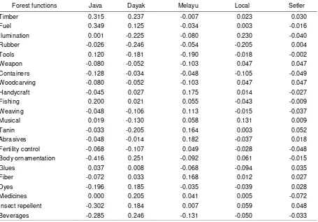
Table 2. The coordinates of canonical correspondence between ethnics and forest functions
Forest functions Java Dayak Melayu Local Setler
Timber 0.315 0.237 -0.007 0.023 0.030
Fuel 0.349 0.125 -0.034 0.003 -0.016
Ilumination 0.001 -0.225 -0.080 0.230 -0.040
Rubber -0.026 -0.246 -0.054 -0.205 0.004
Tools 0.120 -0.181 -0.190 -0.018 -0.002
Weapon -0.080 -0.052 -0.103 0.047 0.047
Containers -0.128 -0.034 -0.048 -0.105 -0.049
Woodcarving -0.080 -0.052 -0.103 0.047 0.047
Handycraft -0.045 0.027 0.175 0.014 -0.027
Fishing 0.200 0.021 0.055 -0.043 -0.009
Weaving -0.048 -0.106 0.113 -0.015 -0.037
Musical 0.019 -0.130 0.058 0.131 0.009
Tanin -0.033 -0.205 0.164 0.003 0.052
Abrasives -0.048 -0.014 0.182 -0.037 0.018
Fertility control -0.068 -0.107 0.049 -0.028 -0.048
Body ornamentation -0.416 0.251 -0.092 0.061 -0.015
Glues 0.037 0.008 -0.068 -0.094 0.035
Fiber -0.072 0.033 0.168 0.012 0.027
Dyes -0.196 0.185 -0.035 -0.039 0.028
Medicines 0.000 0.205 0.041 0.005 -0.072
Insect repellent -0.302 0.184 0.007 0.059 0.048
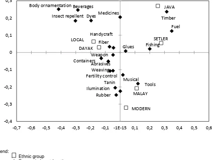
Anthropogenic Forest Appreciation
Our primary focus in this study is to identify the relationship between several ethnic groups and specific forest functions in Kayan Ilir
District. The main axes of the analysis were five ethnic or social groups with cultural and econo-mic predictors (Figure 3).
Legend:
Ethnic group
Economic forest function
Figure 3. The distribution of 22 economics and cultural forest functions, which was identified in Kayan Ilir District.Multi-co-linearity analysis/Canonical correspondence analysis (CCA) ordination diagram between economic and cultural forest functions with five-ethnic-group variable (lines and black box).
Timber
Fuel
Ilumination Rubber
Tools Weapon
Containers
Handycraft
Fishing
Weaving
Musical Tanin
Abrasives
Fertility control Body ornamentation
Glues Fiber
Dyes Medicines Insect repellent
Beverages JAVA
DAYAK
MALAY
MODERN
SETLER LOCAL
-0,4 -0,3 -0,2 -0,1 0 0,1 0,2 0,3
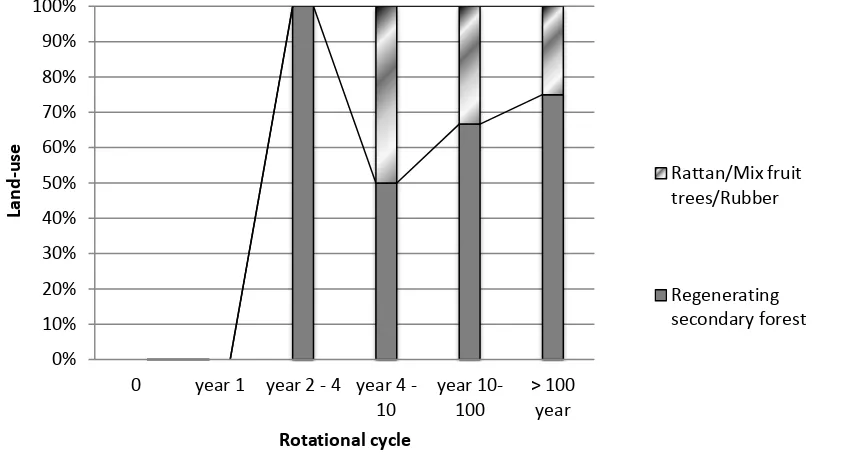
Figure 4. Land Management Cycle by Dayak Etnics
The plot on Figure 4 details the closeness between each ethnic group and certain forest functions, and the dependency of each ethnic on certain forest products. The figure shows that Dayak and Local groups are almost centralized on the centre adjacent with the forest products, which represents the closeness relationship and high dependency of people on forest products and functions. Diversely, Java and settler groups have the long distance with forest products; which represents the low dependency on the forest products and forest functions.
Land Management
The appraisal of land management system reveals how each ethnic group managed the land under their ownership, such as land clearing, preparation, crop selection, cultivating method, fallowing and re-cultivating activities. Results of the appraisal will be explained in the comparison matrix above.
The Dayak and local inhabitants owe the land communally and developed a specific land management system which was the combination of agriculture and forestry. Off farming activities (forestry) in fact generate higher proportion of Dayak's and Local monthly revenue. Dayak's tool for land cleaning activities is simply Machete (Parang), a one edge blade with a maximum 1m in length which has less impact to the forest destruction compared to the saw and sometimes chained saw used by Javanese and Malay. Furthermore, it is common for Dayak to keep several tree species in their field due to their valuable fruits or giving spaces for honey bee hives. Those tree species are: durian (Durio zibethinus), Langsat (Lansium domesticum), jelemu (Canarium pseudodecumanum), banggeris (Kompassia alaccensis),puti (Koompassia exelsa), lomuq (Canarium pseudo-decumanum), kapur (Dryobalanops lanceolata), bengkirai (Shorea laevis) and bilaas (Ficus albifila). The detailed list of the species can be seen in appendix 2.
0% 10% 20% 30% 40% 50% 60% 70% 80% 90% 100%
0 year 1 year 2 - 4 year 4 - 10
year 10- 100
> 100 year
Lan
d
-u
se
Rotational cycle
Rattan/Mix fruit trees/Rubber
Table 3. The comparison of land management between ethnic in Kayan Ilir District
Dayak uses the local 6 month dry land rice (Padi ladang) only in rainy seasons and leaves it fallow until the next cultivation year. After two times of cultivation, they move to another old scrub or secondary forest to clear and turn the previous rice-field into the fruit garden or rubber garden (tembawang). The rotational land management cycle of Dayak can be seen in figure 4 which explains how the Dayak Hovangan in Kayan ilir district utilizes the land starting from opening the primary forest to swidden agriculture, forest garden, fruit garden and back to the forest again in cycle
On the contrary, the Java and Malay use permanent agriculture system with additional inputs to sustain the land productivity (Wicaksono, 2009). The cultivation intensity was two times in a year (Rice-crop-fallowed) which require them to use high agricultural inputs, causing the low benefits of agriculture production.
DISCUSSION
The significant reduction of dry-land forest by almost half was mainly due to minimum control of forest concession in this area which was granted by government (200 units in 1996) and reduced to only 100 units in 2004 (Forestry Department of Indonesia, 2007). Those remaining dry-land forests and log over dry-land
forest's location are adjacent to the National Park which is important to conserve and manage.
According to Mulyoutami et al. (2009). Land-use changes from forested to non forested areas appears common in West Kalimantan where roads are built everywhere and increasing commercial development is based on logging business. Those pressures combined with migrant pressures, create the unsustainable land-use systems which in turn lead to the rapid growth of abandoned land. Furthermore, forest fire and the sequence of logging followed by government and private-sector conversion of secondary forest for settlements, plantations, and mining have radically altered the landscape of West Kalimantan and have greatly reduced its forest cover. In the process, there was significant neglect of the tenure security for small farmers, this gave difficulties to long-term rotational agriculture practice, especially for Dayak households who used such farming systems (Tyynela et al., 2002).
productivity falls below a certain profit level and move on to clear new forest lands. Frequently, migrants will abandon the area after 3-5 years. It is estimated that 10-20% of the land in West Kalimantan has been colonized by Imperata grass (Wilkie et al., 2004).
In contrast with Dayak and Malay ethnic groups which have strong forest stewards, Java ethnic group is attributed with good farming skill, which has been traditionally practiced since centuries ago (Verburg et al., 1999). However, since they are currently modernized, intensification and extensification are the backbone of their agriculture approach until recently (Indonesian Agriculture Research Centre, 2006). This practice creates more distance from the forestry knowledge thus giving more pressures to the forest.
According to Tyynela et al. (2002), the forests in Dayak local context are part of a cultural landscape complex that includes traditional societies as integral components, meeting their livelihood needs from forest-based resources around. While for migrants, the forest has been a source of timber extraction and agriculture land.
Nowadays, conservation and management of biodiversity has become an important forest management concern. There are many failures in forest management and development caused by not revering the traditional value of forest stewards. Unfortunately, the practices of traditional forest management are still at the concept stage and have not yet reached the implementation. Ramakrishnan et al. (2007). Further Siry et al. (2005) stated that Indigenous communities such as Dayak in West Kalimantan have been historically wise stewards of forests and located in regions with the highest diversity of indigenous cultures and associated with traditional knowledge of land management.
Neglecting traditional landscapes in West Kalimantan during 1980s to 1990s has reduced the diversity of forest management forms, creating simplified landscapes often reducing biodiversity of habitats and has disturbed the sustainable forest rotational cycle which leads to an infestation of invasive species such as Imperata grass in many abandoned area. (Abdullah and Nakagoshi, 2007). For the solution, introduction of irrigated and well managed wetland rice-field in chosen area should be conducted to reduce the swidden
activities which threat remaining primary forest. Training and re-education for new settlers and migrants concerning forest value and utilizing non timber forest product (NTFP) is also necessary to create the sustainable landscape.
Finally, innovative forest, agriculture and agro-forestry practices based on traditional knowledge such as Satoyama initiative (Katoh et al., 2009) or Kalimantan fruit garden or forest garden (Tembawang or simpukng), which promote the re-invention of managed "socio-ecological" production landscape by creating and maintaining landscapes of outstanding beauty while sustaining production of quality foods, goods and services can also become the solution enhancing livelihood security and sustaining the West Kalimantan landscape (Agnoletti and Parrotta, 2007).
ACKNOWLEDGEMENTS
We would like to thank Professor Takao Yamashita for giving a chance to visit and conduct the research in West Kalimantan and Professor Hadi Susilo Arifin for a great suggestion. The authors also gratefully acknow-ledge Mr. Endan Suwandana for critical reading of the manuscript. And GELs (Global Environmental Leader) project of Hiroshima University for supporting this research
REFERENCES
Abdullah, S.A. and N. Nakagoshi. 2007.Landscape ecological approach in oil palm land-use planning and management for forest conservation in Malaysia. In: S.K. Hong, N. Nakagoshi, B. Fu, and Y. Morimoto. Landscape ecological applications in man-influenced Areas. p.179-191. Springer, Dordrecht Agnoletti, M. and J.A. Parrotta. 2007.Traditional
forest knowledge: Challenges and opportunities. Forest Ecology and Management 249: 1 – 4
de Jong, W. 1997. Developing swidden agriculture and the threat of biodiversity loss. Agriculture, Ecosystems and Environment 62: 187-197
Indonesian Agriculture Research Center. 2006. Five years of agriculture and development for Indonesia, 1976-1990. Indonesian Ministry of Agriculture, Indonesia. Jakarta
Indonesian Statistics. 2005. West Kalimantan Province statistical profile book year of 2005. BPS Provinsi Kalimantan Barat Lawrence, D., D.R. Peart and M. Leighton. 1998.
The impact of shifting cultivation on a rainforest landscape in West Kalimantan: spatial and temporal dynamics. Landscape Ecology 13: 135-148
Katoh, K., S. Sakai and Takahashi.2009.Factors maintaining species diversity in Satoyama, a traditional landscape of Japan. Biological Conservation 142:1930-1936
Marjokorpi. A. and M. Ruokalainen. 2003. The role of traditional forest gardens in the conservation of tree species in West Kalimantan, Indonesia. Biodiversity and Corservation 12: 799-882
Mulyoutami, E., R. Rismawan and L. Joshi. 2009. Local knowledge and management of simpukng (forest garden) among the Dayak people in East Kalimantan, Indonesia, Forest Ecology and Management 257: 2054-2061
Ramakrishnan, P.S. 2007. Traditional forest knowledge and sustainable forestry A North-East India perspective. Forestry Ecology and Management 249: 91-99
Siry, J.P., F.W. Cubbage and M.R. Ahmed. 2005. Sustainable forest management: global trends and opportunities. Forest Policy and Economics 7: 551-561
Tyynela, T., R. Otsamo and A. Otsamo. 2002. Indeginous livelihood systems in industrial tree-plantation areas in West Kalimantan, Indonesia: Economics and plant-species richness. Agroforestry Systems 57: 87–100. Verburg, P.H. T.A. Veldkamp and J. Bouma. 1999.
Land use change under conditions of high population pressure: the case of Java. Global Environmental Change 9:303-312 Wicaksono, K.P. and N. Nakagoshi. 2009.
Agriculture profile and sustainability in Okinawa prefecture Japan and East Java province of Indonesia. ISTECS 11:1-17 Wilkie, P., G. Argent, E. Cambell and A. Saridan.
2004. The diversity of 15 ha of lowland mixed dipterocap forest, Central Kalimantan. Biodiversity and Conservation 13: 695-708
Appendix 1. The list of cultural and economic functions
List of possible cultural and economic forest functions asked to the respondents
1. Timber (commercial) * 16. Cages/Roosts 31. Prop or Nurse Plants 2. Timber (subsistence) * 17. Parcelization/Wrapping 32. Staple foods
3. Fuel wood * 18. Abrasives * 33. Supplementary Foods
4. Illumination/Torches * 19. Fertility Control * 34. Emergency Foods
5. Rubber * 20. Insulation 35. Wild Foods
6. Tools * 21. Decoration 36. Preservatives
7. Weapons Hunting * 22. Body Ornamentation * 37. Oils
8. Containers * 23. Cordage/Lashing 38. Beverages *
9. Woodcarving 24. Glues/Adhesives * 39. Insect Repellents *
10. Handicrafts * 25. Caulking 40. Scents/Perfumes
11. Fishing Equipment * 26. Fiber/Fabric * 41. Deodorants 12. Weaving/Plaiting * 27. Commercial Products 42. Dyes *
13. Toys 28. Export Products 43. Medicines *
14. Musical Instruments * 29. Ritual Exchange 44. Poisons
15. Tannin * 30. Secret Meeting Sites 45. Recreation
Appendix 2. The list of trees species left behind on Dayak land clearing activitie
Plants Family Local names and usages
Fruits
Durio kutejensis Bombaceae Lai (commercial fruit)
Durio zibethinus Bombaceae Durian (commercial fruit)
Averrhoa bilimbi Oxalidaceae Blimbing (commercial fruit)
Lansium domesticum Meliaceae Langsat (commercial Fruit)
Nephelium lappaceum Sapindaceae Rambutan (commercial fruit)
Nephelium maingayi Sapindaceae Rambutan (commercial fruit)
Garcinia celebica Gutiferae Manggis hutan (fruit)
Garcinia motleyana Gutiferae Manggis hutan (fruit)
Artocarpus chempeden Moraceae Cempedak (fruit)
Mangifera sp Anacardiaceae Mangga hutan (fruit)
Big trees and Honey trees
Canarium pseudo-decumanum Burceraceae Jelemu (Honey tree)
Kompassia malaccensis Caesalpiniaceae Banggeris (Honey tree)
Dryobalanops lanceolata Ebenaceae Kapur (Honey tree)
Shorea laevis Dipterocarpaceae Bengkirai (Honey tree/ timber)
Ficus albifila Moraceae Bilaas (Honey tree)
Dryobalanops aromatic Ebenaceae Ngoik (Honey tree)