VEHICLE TRACKING SYSTEM USING
GPS AND GSM TECHNOLOGY
MOHAMMAD FAIZUL BIN SABAWI
1
CHAPTER 1
INTRODUCTION
The “Vehicle Tracking System using GPS and GSM Technology” project is designed and develop to accommodate the needs of today’s vehicle fleet company to keep track on their fleets. It is a very useful and and versatile device, and in fact it is able to be used by anybody with the need to keep track on their valuable goods and not just by the vehicle fleets company. The desired output from the system will be the data such as position, speed, and time obtained from the GPS receiver and will displayed on the computer screen. This chapter will be covering the general background of this project, its concept, objectives, scope and the problem statement.
1.1BACKGROUND
A vehicle tracking system consists of an electronic device installed on a vehicle so that it could be track by its owner or a third-party for its position. Most of todays vehicle tracking system uses Global Positioning System (GPS) to get an accurate reading of the vehicle position. Communication components such as cellular (GSM) and satellite transmitter will be combined to transmit the vehicle’s position to remote user. Vehicle’s information can be viewed by using a software on a computer.
2
used as a security system, a Vehicle Tracking System may serve as either an addition to or replacement for a traditional Car alarm. The existence of vehicle tracking device then can be used to reduce the insurance cost, because the loss-risk of the vehicle drops significantly.
Vehicle tracking is also useful in many other application such as Asset Tracking scenarios where companies needing to track valuable assets for insurance or other monitoring purposes can now plot the real-time asset location on a map and closely monitor movement and operating status. Meanwhile, in field sales mobile where the situation of sales professionals can easily access real-time locations. For example, in unfamiliar areas, they can locate themselves as well as customers and prospects, get driving directions and add nearby last-minute appointments to itineraries. Benefits include increased productivity, reduced driving time and increased time spent with customers and prospects.
It is has been reported that, with this system, the users has been able to get many benefits by auditing employee hours to insure better utilization of vehicles. This system has also proof its ability to reduce mileage hence, reduce the fuel costs through monitoring private use of vehicles. Reducing the average speed of the vehicles also improve the fuel efficiency. Productivity also will be increased through better budgeting of time and resources.
1.2CONCEPT
3
GPS receiver GSM module
Computer
Figure 1.1 : Overall concept of project
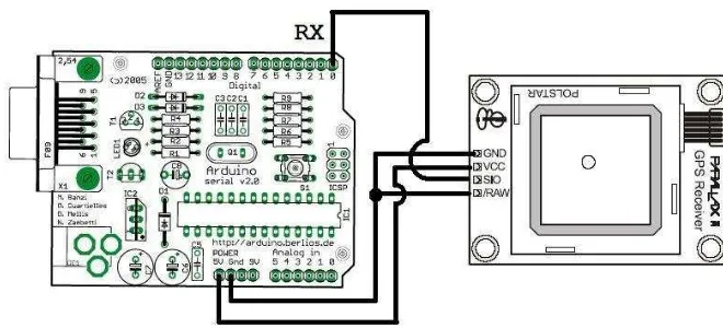
For the first part of this project, the GPS receiver will be paired with the AVR microcontroller. This part is essential to ensure smooth operation for the GPS receiver. A software will be develop using C programming language to operate the microcontroller.
Figure 1.2 : GPS-Microcontroller wiring diagram.
4
1.3OBJECTIVE
The objective of this project is to design and develop a Vehicle Tracking System using GPS and GSM Technology. In order to fully understand both GPS and GSM technology, the research and study on how both technology works is essential to complete the whole project. The objectives of this project are:
I. To study and investigate the basic operation of the GPS module II. To design and develop the GPS/GSM tracking system
III. To come with my own hardware of GPS/GSM tracking system.
1.4SCOPE
The scope of this project is to study and design the GPS/GSM Vehicle Tracking system that can give an output of the information such as time, position, and speed from the GPS receiver. The users will also be able to send command to the GPS receiver using the GSM technology.
The project can be divided into two big part, the first part, the GPS and the AVR microcontroller pairing. The second part, the GPS-Microcontroller and the GSM integration.
For the first part, focus will be on the GPS system and how to pair it to the microcontroller. The study on the how GPS works will be conduct to understand its operation and command set (NMEA) that will be used. The AVR Microcontroller is also an important device to understand as it is a to control the operation of the GPS receiver. The microcontroller using C programming language to operate.
5
1.5PROBLEM STATEMENT
With skyrocketing fuel, maintenance and insurance costs have become an accepted way of life for owners and managers in the service, delivery and transportation industries. The good news is that there is a light at the end of that long, dark, financially depleting tunnel. However, technology has always created alternative pathway for businesses. Technology aid can significantly reduce fuel and maintenance costs, and increase productivity.
For over a decade, GPS vehicle tracking systems have proven to be effective in determining the precise location of a vehicle or asset. GPS tracking uses a system of satellites orbiting the earth to find an approximate placement of the receiver within a few meters of its actual location. Systems range from the passive, battery operated tracking key, to the highly sensitive, active or real time systems with various installation options. Both are designed to enhance fleet efficiency and profitability by monitoring driver location and speed.
6
1.6OUTLINE
7
CHAPTER 2
LITERATURE REVIEW
In this chapter, the articles of the GPS history, GSM communication technology, brief on the components theory and a couple of similar projects are covered.
2.1HISTORY OF GLOBAL POSITIONING SYSTEM (GPS)
The GPS System was created and realized by the American Department of Defense (DOD) and was originally based on and run with 24 satellites (21 satellites being required and 3 satellites as replacement). Nowadays, about 30 active satellites orbit the earth in a distance of 20200 km. GPS satellites transmit signals which enable the exact location of a GPS receiver, if it is positioned on the surface of the earth, in the earth atmosphere or in a low orbit. GPS is being used in aviation, nautical navigation and for the orientation ashore. Further it is used in land surveying and other applications where the determination of the exact position is required. The GPS signal can be used without a fee by any person in posession of a GPS receiver.
8
At first only 18 satellites should be operated. 1988 the number of satellites is again raised to 24, as the functionality is not satisfying with only 18 satellites.
Launching of the first Block I satellite carrying sensors to detect atomic explosions. This satellite is meant to control the abidance of the agreement of 1963 between the USA and the Soviet Union to refrain from any nuclear tests on the earth, submarine or in space. When a civilian airplane of the Korean Airline (Flight 007) was shot down after it had gone lost over Sovjet territory, it was decided to allow the civilian use of the GPS system. In 1986, the accident of the space shuttle "Challenger" means a drawback for the GPS program, as the space shuttles were supposed to transport Block II GPS satellites to their orbit. Finally the operators of the program revert to the Delta rockets intended for the transportation in the first place.
In 1989, the first Block II satellite was installed and activated. Temporal deactivation of the selective availability (SA) during the Gulf war. In this period civil receivers should be used as not enough military receivers were available. On July 01, 1991 SA is activated again. The Initial Operational Capability (IOC) is announced in 1993. In the same year it is also definitely decided to authorize the world wide civilian use free of charge.
The last Block II satellite completes the satellite constellation in 1994. Full Operational Capability (FOC) is announced the following year. In 2000, final deactivation of the selective availability and therefore improvement of the accuracy for civilian users from about 100 m to 20 m.
2.2GSM TECHNOLOGY
9
GSM has used a variety of voice codecs to squeeze 3.1 kHz audio into between 5.6 and 13 kbit/s. Originally, two codecs, named after the types of data channel they were allocated, were used, called Half Rate (5.6 kbit/s) and Full Rate (13 kbit/s). These used a system based upon linear predictive coding (LPC). In addition to being efficient with bitrates, these codecs also made it easier to identify more important parts of the audio, allowing the air interface layer to prioritize and better protect these parts of the signal. GSM was further enhanced in 1997 with the Enhanced Full Rate (EFR) codec, a 12.2 kbit/s codec that uses a full rate channel. Finally, with the development of UMTS, EFR was refactored into a variable-rate codec called AMR-Narrowband, which is high quality and robust against interference when used on full rate channels, and less robust but still relatively high quality when used in good radio conditions on half-rate channels.
There are five different cell sizes in a GSM network—macro, micro, pico, femto and umbrella cells. The coverage area of each cell varies according to the implementation environment. Macro cells can be regarded as cells where the base station antenna is installed on a mast or a building above average roof top level. Micro cells are cells whose antenna height is under average roof top level; they are typically used in urban areas. Picocells are small cells whose coverage diameter is a few dozen meters; they are mainly used indoors. Femtocells are cells designed for use in residential or small business environments and connect to the service provider’s network via a broadband internet connection. Umbrella cells are used to cover shadowed regions of smaller cells and fill in gaps in coverage between those cells.
10
2.4.1 GSM MODEM
A GSM modem is a wireless modem that works with a GSM wireless network. A wireless modem behaves like a dial-up modem. The main difference between them is that a dial-up modem sends and receives data through a fixed telephone line while a wireless modem sends and receives data through radio waves.
A GSM modem can be an external device or a PC Card / PCMCIA Card. Typically, an external GSM modem is connected to a computer through a serial cable or a USB cable. A GSM modem in the form of a PC Card / PCMCIA Card is designed for use with a laptop computer. It should be inserted into one of the PC Card / PCMCIA Card slots of a laptop computer. Like a GSM mobile phone, a GSM modem requires a SIM card from a wireless carrier in order to operate.
2.4.2 SUBSCRIBER IDENTITY MODULE (SIM)
One of the key features of GSM is the Subscriber Identity Module (SIM), commonly known as a SIM card. The SIM is a detachable smart card containing the user's subscription information and phone book. This allows the user to retain his or her information after switching handsets. Alternatively, the user can also change operators while retaining the handset simply by changing the SIM. Some operators will block this by allowing the phone to use only a single SIM, or only a SIM issued by them; this practice is known as SIM locking, and is illegal in some countries.
2.3SIMILAR PROJECTS.
There has been many other project on the internet that uses the same concepts applied on this project. But most of the project use a combined GPS and GSM module, as it is easier to operate. Here is the example of the project found on the internet:
11
Figure 2.1 : Telit GM862 module used for a tracking system [11]
The inventor is unknown but his goal is to build a kind of a mobile tracker. There are many different use cases we can think of but one of the obvious is a device, that is able to report where it is. This device can be put in the car and it could trigger an alarm, if the car got stolen. It actually could tell you where it is.
There are already mobile tracking devices out there, but they seemed to be too expensive and too closed for our needs. Another option is one of these new Nokia N95 which have built-in GPS. They are really nice, but about 600€, which is not a bargain.