Ecological Balance of Sethusamudram Canal, India: special reference to Mangrove Ecosystem
10
ReviewECOLOGICAL BALANCE OF SETHUSAMUDRAM
CANAL, INDIA: special reference to mangrove ecosystem
Oswin D. Stanley*
Eco-Balance Consultancy
6B, Umiya Park Society, Subhanpura-370 009Vadodara, Gujarat, India
Received: May 7, 2004 ; Accepted: May 14, 2004
ABSTRACT
Impact of Sethusamudram canal on the southeast coastal ecosystems is assumed to be diverse. The paper discusses the significance and status of the mangrove ecosystem in specific to Tamil Nadu coast, the impact of the project on the mangroves, the presumptive ecological and economical dynamics this also suggests a rational ecosystem management tool.
Key words: Sethusamudram, dredging, impact, eco-eco-dynamics, management tool
*Correspondence: Phone: + 91-94263 34634; E-mail : ebcbaroda@yahoo.co.in
I
NTRODUCTION
Several studies to speculate the impacts of dredging Sethusamudram canal have been already instigated through a range of organizations. It is a fact that the project envisages several impacts on the environment, economy and the society. It is inevitable to understand the present ecological situation and evolve with a management tool to rationally confront the vigorous changeovers.
Sethusamudram project may influence alterations in the coastal habitats, which would have definite reflection on the environment and ultimately on the socio-economical configuration. The fragile mangrove ecosystem which lie at the south east coast was given due
importance to contemplate the impact of the project on mangroves, the dependent society and the allied economy thereof. The paper discusses the background of the project, the unique mangrove wetland, the impact of dredging on the ecosystem and the presumptive economic dynamics.
B
ACKGROUND OF
S
ETHUSA-MUDRAM
P
ROJECT
Ecological Balance of Sethusamudram Canal, India: special reference to Mangrove Ecosystem
10
Sri Lanka saving the voyage time and distance.
The Sethusamudram Canal originates from Tuticorin Port, extending in north east direction in the Gulf of Mannar up to Rameswaram area. It cuts through Adam's Bridge and proceeds in Palk Bay area al-most parallel to Indo-Sri Lankan boundary line (about 3 km. from the boundary) and joins the Bay of Bengal channel opposite to Point Calimere. The entire alignment will be within Indian waters.
The total length of canal will be about 260 km, about 120 km from Tuticorin Port to Adam's Bridge (in Gulf of Mannar) and about 140 km north of Rameswaram from Adam's Bridge to Bay of Bengal channel (in Palk Bay). The canal is being investigated for different draughts (for 9.15 m (30'), 10.7 m (35') and 12.8 m (42').
Adam's Bridge (79027’-79042’E longitudes and 9004-9009’N latitudes) comprises 103 small patch reefs lying in a linear pattern with reef crest, sand cays and intermittent deep canals. The linearity of the bridge suggests an old shoreline from the mainland of Pamban, Rameshwaram Island, Adam's Bridge and the mainland of Jaffna, where coral reef evolved (Anjali et al, 2003). Ramayana and related myths mangroves, estuaries, lagoons, lakes etc., including coastal waters up to a depth of 6m (Ramsar Convention, 1971) and are the most productive zones of the globe that convert the solar energy into potential
nutrients to the lower food web pyramid. Mangroves are the tropical plants occur-ring in the inter phase between land and sea. Mangroves have special adaptations such as pneumatophores or breathing roots, buttress, salt excreting (salt glands in the lamina), excluding (ultra filtering system in the roots) and accumulating mechanisms, viviparous or semi-viviparous type of seeds and buoyant seed dispersal device to survive in such extremely vulnerable coastal conditions.
FSI Survey 2001 states that the mangrove forest cover in India is 4481 Sq.Kms. About 9 states and Union territories in the country have mangroves in their coastal regions. Southeast coast mangroves especially which lie at Tamil Nadu with in the proposed Sethusamudram project cover an area of 23 Sq.Kms. Mangrove mapping by MSSRF, 2002 states that the mangrove cover in this zone is 15 Sq.Kms (15,035 ha). Good mangrove coverage is available at Cuddalore: Uppanar- Coleroon estuarine region (Pichavaram), Thanjvur: Coleroon estuarine region (Puthupattinam), Thiruvarur and Thanjavur: distributaries of Vennar (Muthupet), Ramanathapuram: Islands of Gulf of Mannar (Gulf of Mannar Marine National Park), Ramanathapuram: Mouths of tidal creeks (Palk Strait) and Tuticorin: Tamiraparani estuary (Gulf of Mannar Marine National Park). The number of species recognized from Indian mangroves is 65 belonging to 22 genera and 16 families (Kathiresan and Bingham, 2001) and in Tamil Nadu excluding the associates it is 18 true mangrove species.
Ecological Balance of Sethusamudram Canal, India: special reference to Mangrove Ecosystem
10
coast was named as forest that suppresses the force of the waves and storms thereby protecting the land and people thereof.
Traditionally mangroves have a major role in the health of the coastal inhabitants. Acanthus ilicifolius is an antiseptic, Excoecaria agallocha is used for curing leprosy, Azima tetracantha is used during child delivery to reduce pain, the tender leaves of Avicennia marina is chewed instead of betel leaves. The twigs of Excoecaria agallocha are used in the illegal preparation of arrack in many coastal villages of southeast coast. The fruits of Sonneratia apetella are used to prepare jams, jellies, soft drink and ice creams; Srilanka Small Fishers Federation is commercially producing this fruit for the development of the fisher community. The larvicidal, fungicidal and antiviral activi-ties of the mangroves were also proved. Mangroves help in the apiary industry and the honey produced from the pure
Avicennia stand in Muthupet (southeast
coast) has the excellent medicinal value. Sunderbans provide employment to 2000 people extracting 111tons of honey annually, which account for the 90% of honey production among the mangroves of India (Chaudhuri and Chaudhury, 1994). The mangroves have the UV absorbing
pigments in their photo system II and that reduces the incident of radiation related diseases of the coastal inhabitants (Oswin and Kathiresan, 1994).
Ecological Balance of Sethusamudram Canal, India: special reference to Mangrove Ecosystem
10
T
HE
P
RODUCTIVE
C
OAST OF
T
AMIL
N
ADU
Tamil Nadu (8 5' and 13 35' N Latitude and 76 15' and 80 20' E Longitude) has an area of 130058 Sq.Km with the population of 62110839. The coastline of Tamil Nadu is 1076 Km covering 13 coastal villages and 25 blocks. The numbers of fishing villages are 591 including many hamlets. Marine fishery production during 2000-2001 is 372402 Tonnes.
The length of Coramandal coast that is Palk Bay (130 km) and Gulf of Mannar (141 km) together is 271 Km. Particularly in this coast 2861 mechanized boats and 8403 country boats are operating. There are 4 jetties and 17 landing centers in the 78 marine fishing villages with the
fishermen population of 124387. A total of 87508 tonnes of fish was caught in Coramandal coast using different gears such as Trawl net, Surrounding net, Gill net, Seine net, Line fishing and other traditional methods. This coast is well known for pearl fishery since Pandya’s reign. Jadhi Chanks are in abundant in the Palk Bay strait and Gulf of Mannar. More than 2000 fishermen are engaged in active chank diving and sacred chanks collected by divers are marketed to West Bengal for making ornaments. This contributes signi-ficantly to the development of fisheries. Central Marine Fisheries Research Institute is in the verge of launching programs on sea ranching of chank as a conservation measure of the chank diversity.
Ecological Balance of Sethusamudram Canal, India: special reference to Mangrove Ecosystem
10
around Thengapattinam estuary, formed by the confluence of river Tampirabarani in between Thengapattinam and Eraium-manthurai, Valliyar estuary by river Valloiyar near Kadiapattinam and Manakudy estuary river Pazhayar in between East and West Manakudy villages. Apart from these there are two minor estuaries in Pambar estuary near Colachel and Pantri estuary near Rajakkamangalam. These estuary mouths have mangroves, which are treated as potential fisheries resources. Annual harvest of seaweeds is Gelidiella (74 tonnes), Gracilaria (974 tonnes), Hypnea (798 tonnes), Sargassum and Turbinaria (9381 tonnes). Total annual marine and estuarine fish catch during 2003-04 is 42,495 tonnes.
Environmental inventory of Muthupet mangrove (Latitude 100 46’ N; Longitude 790 51’E), located at the southern end of the Cauvery delta on the Coramandal coast was studied by Oswin (1998). The total area of the reserved forest zone is 11,885.91 ha. The tributaries of river Cauvery: Paminiyar, Koraiyar, Kilithangiyar, Marakkakoraiyar and Valavanar converge into the Bay through this lagoon. Mono generic dominance of
Avicennia marina (4-15m) in the saline
lagoon area and Excoecaria agallocha (3-12m) in the riverine region as distinct patches is the unique character of Muthupet. The biodiversity status consists of 13 species of mangroves, 49 associates, 6 species of sea grass, 10 species of seaweeds, and 6 fresh water hydrophytes particularly during monsoon, 18 species of Molluscs, 14 species of Crustaceans, 73 species of Fishes, 112 species of Insects, 13 species of Spiders, 10 species of Herpetofauna, 160 species of Birds and 13 species of Mammals (Oswin, 1999). Species of mullet, milkfish, pearl spot, clam, oysters, shrimp and mud crab are the major components of mangrove fish catch
in this coast. Annual organic matter flux is 6.3 Metric tones/ha and fish catch is 106.55 tons.
The Pichavaram mangroves (Lati-tude. 11027’ N; Longitude. 79047’ E) cover an area of 1100 ha including 51 crisscross islets. 10% of the area is mudflats, sandy flats, salty soils and oyster beds. Waterways comprise about 40% and 50% forests. There are 94 species of phytoplankton, 61 species of mangroves, 95 species of zooplankton, 197 species of fishes, 36 species of crabs and 177 species of birds. There are about 1700 families depending directly on fishing with 500 canoes. The nutrient flux from the mangroves is 8 tonnes organic matter/ha/annum and annual fish catch in Pichavaram is 237 tonnes.
I
MPACTS
OF
D
REDGING
S
ETHUSAMUDRAM
C
ANAL ON
M
ARINE
E
NVIRONMENT
Ecological Balance of Sethusamudram Canal, India: special reference to Mangrove Ecosystem
10
time. Turbulence may in turn affect on bank stability, water turbidity, bank erosion, dislodge benthic micro-invertebrates and disturb fish eggs and larvae in the edges of a waterway.
Pollution of marine water due to ship discharges, oil spills, addition of toxic substances in water column and air pollution due to fugitive emmisions may not be ruled out. Since there is a considerable impact on fishery resources and habitats dredging and impact assessments should involve Fishery depart-ment as a major assesdepart-ment agent. Protecting, maintaining and restoring fish habitats are essential measures to sustain fisheries productivity. Through the provisions of the Fisheries Act, negotiation with stakeholders is necessary to ensure recognition of fish habitats, and the protection to be given to these habitats, where dredging approvals are sought.
S
ETHUSAMUDRAM -
C
OASTAL
E
COSYSTEM
M
ANAGEMENT
Ecosystem approach may be an effective tool in managing the ecological balance of mangrove ecosystem. Ecological balance is a state of dynamic equilibrium within a community of organisms in which genetic, species and ecosystem diversity remain relatively stable, subject to gradual changes through natural succession. The goal of the ecosystem approach is to restore and sustain the health, productivity, and biological diversity of ecosystems and the overall quality of life through a natural resource management approach that is fully integrated with social and economic goals. The ecosystem approach can provide clear economic and social benefits to the nation by protecting, restoring, and
sustaining ecosystems that are critical to the local economies.
Many in the public mostly feel powerless to influence Government actions that affect them. The approach recognizes the fundamental connection between human communities and the environment. The key elements of the ecosystem approach are more public-private partner-ships, more intergovernmental cooperation, more integrated planning, and a broader and longer-term perspective in making decisions affecting natural resources.
Ecological Balance of Sethusamudram Canal, India: special reference to Mangrove Ecosystem
10
P
RESUMPTIVE
E
COLOGICAL -
E
CONOMICAL
D
YNAMICS
The entire mangrove cover of Tamil Nadu lies in the Sethusamudram project area. It is being recognized that mangrove forests are highly productive ecosystems which are not only able to provide a wide range of valuable forest products, but can also
play an important role in the life cycle of many commercially important fish, crustaceans and mollusks (Jussof and Majid, 1990). The economical benefit rendered by mangroves particularly in terms of fisheries alone is taken into consideration to approximately evaluate the fishery value provided by the ecosystem.
Table 1.. Estimation of fishery contribution from the Sethusamudram project area
Fishery Detail
Production (Kg/day/ha)
(As per the estimation at Pichavaram
5657.5 13012.25 1,36,909
The economical benefit per day at Pichavaram is 604/- and 130/- respectively for shell and finfish (Total: 734/-).
The total fishery production in 23 sq.km of mangrove areas in Tamil Nadu is 13012 tons per annum (36 tons/ha/annum). The amount of shellfish and finfish production is 9235 and 3778 tons/ha/annum respectively. The shellfish production in mangroves is 71 percent and it is triple fold of the finfish production.
Based on the approximate estimation of the quantity of fish from the project area, the prawn fishery contributes three (3:1 prawn: fish catch) portions of the fish catch and four fold (4:1 prawn fish cost) local economy of the society, would be posed to threat forever if the mangroves are denuded or disturbed.
The contribution of south east coast (project area) from the Exclusive Economic Zone (EEZ) wild marine fisheries catch is 1108 tons (MPEDA). The total fishery exports from Indian EEZ area is 3900 tons and the export fishery contribution from the project area is 28.4 percentage. The export value of prawns is
$7.07/kg and fish is $0.89/kg, and perhaps a considerable loss of export income be hypothesized if mangroves are lost.
Ecological Balance of Sethusamudram Canal, India: special reference to Mangrove Ecosystem
10
throughout Cauvery basin is of commercial value; nearly two thirds of the fish caught are hatched in mangroves and tidal waters. Muthupet mangroves in the southeast coast act as a habitat for over 73 species of fish, 17 species of mollusks and 14 species of crustaceans and also show the fish catch composition of 67% fin and 33 % prawns respectively (Oswin, 1998); and in Jakhau-Gulf of Kachchh mangroves, Gujarat, India the catch shows the proportion of 30% prawns and 70 % other fish.
Mangroves provide direct employment of 0.5 million-fisher folk and a total of one million jobs worldwide are dependent on mangrove-associated fisheries. The density of population dependent on mangroves is estimated at about 5.6 person / Sq.km (FAO, 1988).
The fishing industry is one of the most significant examples of the economic importance of the long-term sustainable management of ecological resources. Yet major proportion of the nation's commercial species is over-fished or being harvested at a level that cannot be sustained. Fisheries Department is supposed to impose strict regulations to increase dwindling stocks of fishery resources. Sustainable management of ecological resources could prevent declines in commercial fisheries and provide significant economic benefits. Fishing industry is directly dependent on the health of coastal ecosystems because 90 percent of the commercial fish speciesis in the wild require estuarine wetland habitat during some phase of their life cycles.
For instance, the nutrient flux from two mangroves (Picahavaram: 8 tons organic nutrients and Muthupet: 6.3 tons organic nutrients) provides constant nutrient input to the project area, which has a major role in the wild fishery development of the ocean.
Reduction of mangrove areas for any reasons has a direct impact on the decline
of fisheries. This hypothesis is substantiated through records such as that the reduction of 40% of mangrove area in Vedaranyam, south east coast of India recorded a fall of 18% fishery resources with in a period of 13 years between 1976 and 1989 (Padmavathi, 1991); shrimp production has fallen to almost nil due to the clearance of mangroves in Cochin backwaters for residential reclamation (Mastaller, 1996); removal of 50% of mangroves affected the 40% of the shrimp catch in Malysian waters (Chong et al., 1996). Continued loss of mangroves may have substantial economic and social costs. Indian Government has already declared the marine biodiversity of Gulf of Mannar (Sethusamudram Project Area) as Biosphere Reserve in 1989 understanding the unique characteristics. Any economical developmental projects planned in such sensitive and valuable ecosystems may be scrutinized in the ecological angle to minimize the negative impacts. Though there are impressive economical benefits estimated through Sethusamudram Project, perhaps affect the economy of the nation in forthcoming years in an irrevocable form if natural resources are distorted. It is important to estimate various facets of expected changes and strategize an integrated management plan (both resource and stakeholders) for sustainable use of natural resource, fishery economy and the expected benefits of the Sethusamudram project.
C
ONCLUDING
R
EMARKS
Ecological Balance of Sethusamudram Canal, India: special reference to Mangrove Ecosystem
10
been erased off from its original location. The loss of coral reef ecosystem due to the Sethusamudram canal also would have a major implication on the ecological balance and economy. It should be understood that investing and restoring the lost sensitive ecosystem would pay only an insignificant result. However, investing in and protecting our existing environment will in-turn ensure long-term sustainability of our natural resources, and thereby balance and sustain the economies, which rely upon the natural resource base.
R
EFERENCES
Anjali B., S, Nayak and B. Deshmukh, 2003. IRS views the Adams Bridge (Bridging India and Sri Lanka). J. Ind. Soc. Remote
Sensing 31:.
Chaudhuri, A.B. and Chaudhury, A., 1994.
Mangroves of the Sunderbans,
India, 1: 247.
Chong, V.C., Sasekumar, A. and Wolanski, E, 1996. The role of mangroves in retaining penaeus prawn larvae in Klang Strait, Malaysia. Mangroves. Salt. Marsh. 1:1-22.
FAO 1998. Worldwide compendium of
mangrove associated aquatic
species of economic importance.
FAO Fisheries Circular No 814 (FIRI – C814), Rome, 236pp.
Jussof, K and Majid, N.M. 1990. Inventory and monitoring of forested wetland resources of ASEAN. J. Forest
Ecol. Manag. 33/34: 63-79.
Kannupandi, T., S. SoundraPandian and N. Rajendran, 2003. Prawns and
Shrimps, Biodiversity in Mangrove
ecosystems: UNU UNESCO
International training Course, 2003.
Kathiresan, K and Bingham, B.L., 2001. Biology of mangrove and mangrove ecosystems. Adv. Mar.
Biol. 40: 81-251.
Kathiresan, K. and N. Rajendran, 2000.
Flora and fauna in Indian
Mangrove ecosystem: East Coast.
In Kathireasn, K (Ed), Flora and Fauna in Mangrove ecosystem: A Manual for identification, 1-49.
Kathiresan, K. and Rajendran 2002. Fishery resources and economic gain in three mangrove areas on the southeast coast of India. Fish.
Manag. Ecol, 49 (5):277-283.
Martosubroto, P. and Naamin, N. 1977. Relationship between tidal forests and commercial shrimp production in Indonesia. Mar. Res. Indon, 18: 81-86.
Mastaller, M., 1996. Destruction of
mangrove wetlamds-causes and consequences. Natural resources
and Development. Institute for Scientific Co-operation, Tubingen, Federal Republic of Germany.
MSSRF, 2002. Atlas of mangrove wetlands
of India, Part I Tamil Nadu.
Oswin D. S, 1998. Survey, Utilization and
Conservation of natural resources of Muthupet mangroves, southeast coast of India. PhD Thesis,
Ecological Balance of Sethusamudram Canal, India: special reference to Mangrove Ecosystem
10
Oswin, S.D and K.Kathiresan 1994. Pigments in mangrove species of Pichavaram, Ind. J. Mar. Sci., 23 : 64-66
Oswin, S.D., 1998. Biodiversity of the Muthupet mangroves, southeast coast of India. Seshaiyana. 6 (1): 9-11.
Oswin.S.D. 1999: Avifaunal diversity of Muthupet Mangrove forest, Zoo’s
Print Journal 14(6): 47-53.
Padmavathi, M., 1991. In: Proceedings of National Symposium on Remote Sensing on environment. Chennai, Anna University, 8-10.
Primavera, J.H., 1998. Mangroves as Nurseries: shrimp populations in mangrove and non-mangrove habitats. Estuar. Coast. Shelf. Scie. 46 (3):457-464.
Rajendran, N and K. Kathiresan, 1999. Seasonal occurrence of juvenile prawn and environmental factors in Rhizophora mangal, southeast coast of India. Hydrobiologia, 394:193-200.
Ramesh, MX, and K. Kathiresan, 1992. Mangrove cholesterol in the diet of penaeid prawn, Penaeus indicus.
Ind. J. Mar. Scie, 21 (2):164-166.
Ramsar Convention 1971, In: Kabii T, P. Bacon, 1997. Protection of wetlands and coastal klands and their habitats. Vol 2, Topic 11, XI
World Forestry Congress, Antalya, Turkey, 13 to 22 October 1997.
Vance, D., Haywood, M. D. E., Heales, D.S. and Staples, D.J, 1996. Seasonal and annual variation in abundance of larval and juvenile grooved tiger prawns Penaeus
semisulcatus and environmental
variation in the Embley River, Australia: a six year study. Mar.
Tritium Transfer and Concentration In the Ocean
13
ReviewTRITIUM TRANSFER AND CONCENTRATIfON IN THE OCEAN
Eko Hidayanto*
Department of Physics, Diponegoro University, Semarang – 50275, Indonesia
Received: June, 6, 2004 ; Accepted: August, 4, 2004
ABSTRACT
Environmental transport models have been developed for evaluation of radiation doses from tritium released into the atmosphere. Recently, models contain not only inhalation and skin absorption as routes of tritium transfer from the atmosphere to humans, but also the ingestion pathway. Tritium releasing to the environment is contribute to added tritium concentration in the ocean. This paper describes the tritium transfer from the environment to the human body and the possible health effects if it is taken inside the body, the factors which influence the differences of tritium concentrations in the coastal seawater, and the formula of the tritium concentration balance in the ocean surface.
Key words : Tritriated water, HTO, HT
*Correspondence : Phone (024) 7474754, E-mail: ekohidayanto@yahoo.com
I
NTRODUCTION
Tritium (3H) is a radioactive form of hydrogen. Tritium is produced both by natural process, the interaction of cosmic rays with the atmosphere and by man-made process (in nuclear reaction). The half-life of tritium is 12.3 years. This means that the concentration of tritium in the environment is reduced by one-half in every 12 years, disregarding newly generated tritium. When tritium undergoes radioactive decay, it is transformed into non-radioactive helium through the emission of a “beta” particle, or electron from its nucleus. The very low energy radiation emitted by tritium is too weak to cause a radiation hazard outside to the human body. The radiation from tritium can only travel about 5 millimeters in the air and can be stopped completely by a sheet of paper or by ordinary clothing.
Tritium can deliver a radiation dose, if it is taken inside the body. Such an intake could occur by breathing tritiated water vapor in the air, or by eating or drinking tritium-contaminated foods or water. Even though tritium radiation cannot penetrate skin, tritiated water vapor in the air, like regular water vapor in the air, may be absorbed through the skin. Likewise, a person might absorb small amounts of tritiated water through the skin when swimming or wading in contami-nated water. A developing fetus could also receive tritium absorbed into its mother’s body through one of these routes.
-Tritium Transfer and Concentration In the Ocean
13
OH, -SH and –NH. The skeletally bound tritium is not easily exchanged with FWT, while the tritium in other organic compounds quickly equilibrates with FWT. Limited data concerning the non-exchangeable fraction of OBT are available, and 60-90% of organic materials are estimated to be non-exchangeable. In comparison with FWT, OBT generally remains in organisms for longer periods, and tritium is more easily assimilated into OBT fraction of organisms.
Tritium in food is also classified into two types: FWT and OBT. The contri-bution of OBT in foods, after a radiation dose of released tritium, strongly depends on season that the tritium released. In the environment, tritium is also classified into gas tritium (HT) and metan tritium (CH3T). While most of the leaked tritium will be in the form of HT and HTO, other tritiated organic compounds like CH3T may be included. Since the bioavailability of HT to plants and animals is lower than HTO, HT will give lower dosage of radioactivity per unit than HTO. However, when HT is deposited on the ground, it is quickly oxidized into HTO, mainly by microbial activity. HTO is incorporated into the human body by both inhalation and by ingestion of contaminated foods.
Natural process of tritium is produced in the environment as the result of the interaction of cosmic rays and the atmosphere gas. After tritium formed in the atmosphere, it changed into the water
molecule through oxidation process, and then would reach the terrestrial surface and the ocean surface by the rain.
Since the early 1960’s when a large amount of tritium was discharged into the atmosphere and that the number of atmospheric nuclear test which is a major source in the atmosphere has decreased, tritium levels in recent precipitation have decreased in the environment. From a global point of view, low tritium levels have been measured in places where oceanic climate predominates over continental climate(Sheell et al., 1974).
Momoshima et al. (1986) reported that Japanese coastal seawater has about two times higher tritium levels than eastern Pacific surface water indicated that coastal seawater is apparently by runoff from land in spite of the sampling being carried out the place where river water does not flow into the ocean.
A
TMOSPHERIC
T
RITIUM TO
H
UMAN
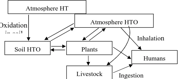
The transfer pathways of tritium released into the atmosphere, in the form of HTO, are outlined in Fig. 1. Atmospheric HTO in puff from sources, is deposited from the atmosphere to the ground where part of it may absorbed by plants via the root system.
Fig. 1. Conceptual model of tritium transfer from atmosphere to humans
Atmosphere HT
Atmosphere HTO
Soil HTO Plants
Humans
Livestock
Oxidation
in soil
Inhalatio
n
Tritium Transfer and Concentration In the Ocean
13
Direct deposition of HTO on plan surfaces is also considered to be an important transfer pathway. After the puff has passed, HTO is re-emitted from the soil and plants back into the atmosphere. Tritium is also transferred from the atmosphere to farm animals via inhalation, skin absorption, and ingestion of contaminated foods. The skin absorption pathway is not considered to be as important as the inhalation route. Tritium is taken by humans via inhalation of atmospheric HTO and ingestion of tritium contaminated plant and animal foods.
HT does not remain in plant and animal tissues for long periods, therefore radiation doses from HT are thought to be insignificant unless the receptor is directly immersed in the puff (Okada and Momoshima, 1993). The residence time of HTO in organisms is generally far longer than HT (Murphy, 1993). Therefore, oxidation of HT to HTO is an important factor in the dose evaluation of tritium.
Oxidation of HT in the atmosphere the soil is mainly a biotic process, although a weak abiotic activity is known to occur. Sterilization of soil with heat (McFarlane et al., 1978), chemicals (Suscet and Murphy, 1981) or radiation (Momoshima et al., 1992) inactivates the majority of the soils oxidation capability. Deposition velocity and oxidation of HT, from the atmosphere to the soil, depends on the soil’s void content, temperature and location(Dunstall et al. 1985; Forstel 1986, Spencer and Dustal, 1986). Water content deposition velocity increases with decreasing water content, it decreases in
conditions of extremely low water content because of the reduction in biotic activity. Since oxidation capability depends on the sampling location of the soil, local parameters are important in realistic dose estimations.
Environmental models have been developed to evaluate radiation doses of tritium released into the atmosphere. Raskob developed the UFOTRI code which is the first environmental transfer model to combine inhalation with the long term ingestion pathway. The UFOTRI code consists of a Gaussian dispersion model and a biosphere compartment model. Doses of released tritium depend on many factors such as release height, climatic condition and season. Table 1 shows a few examples of the model’s result for a person receiving maximum exposure; 1 km away from a release point. In these cases, the dose contributions via the ingestion pathway exceed those of the inhalation route, although all foods were assumed to be produced locally (Raskob, 1995). However, the fractional dose contri-butions of the ingestion depend on the various local conditions. Generally, higher contributions were observed in high total dose cases (Gulden and Raskub, 1992).
Table 1. Estimated dose to maximum
exposed person from accidental
Released emitted during the decay of tritium nucleus is insufficient to penetrate skin, this report does not address external radiation exposure, but only internal dose routes. The following exposure pathways were considered:
Tritium Transfer and Concentration In the Ocean
13
2. Tritiated ingested with water during swimming or wading, home-grown foods, or breast-milk (in the case of infants) and absorbed into the body through the gastro-intestinal tract. 3. Tritium from tritiated water vapor in air
taken through the skin.
4. Tritium from tritiated water in surface water taken through the skin during activities that involve dermal contact with the contaminated water, i.e., washing, swimming and wadding in surface water.
5. Tritium transferred from the body water of pregnant women to the developing fetus.
A
TMOSPHERIC
T
RITIUM TO
R
ICE
Although rice is an important food source, the transfer dynamics of tritium from the environment to rice are poorly understood. A small green house was constructed outside for the exposure experiments, and HTO vapor was introduced into it for 24 hours. HTO transfer from the atmosphere to rice plant was examined at different intervals after anthesis.
The transfer of HTO from the atmosphere to plant tissue is described by a following formula (International Atomic Energy Agency, 1990).
Cp=α(RhCa)+(1-Rh)Cs(1-eλt) With Cp is HTO concentration in plant tissue, Ca is HTO concentration in air, Cs is HTO concentration in soil, Rh is relative humidity in air, α is rate constant for transfer from atmosphere to plant tissue, λ is isotope correction and t is time elapsed from the beginning of exposure. Rate constant α was obtained from the measurement results of plant samples by non-linear least square fitting method under the assumption of constant λ during exposure. variation can be attributed to differences in some geographical and hydrographical situations/residence time of water, tritium concentration of supplied water, a turnover rate of coastal seawater etc.
The tritium balance in the ocean is expressed by the following equation (Altison and Holmes, 1979).
d(V1T1) / dt = ∑I1T1 – EBT1s with tritium concentration T1 E : rate of evaporation
Oj : rate of outflow to sink j Ta : tritium concentration of
atmospheric water vapour X : exchange rate
B : HTO-H2O fractionation factor
λ : decay constant for tritium.
The formula is simplified by ignoring minor contribution terms such as the radioactive decay and the exchange of tritium between the atmosphere and the ocean surface.
H
AZARDOUS
T
RITIUM
TO
H
UMAN
H
EALTH
Tritium Transfer and Concentration In the Ocean
13
The only studies that show radiation effects on human health are studies of individuals exposed to high dose levels (e.g., from the atomic bombing of Hiroshima and Nagasaki) – well above those associated with background radiation, which are orders of magnitude higher than tritium from the environment. It is assumed that low-dose radiation does affect health. The health risk estimates in the risk assessment are extrapolated from effects observed only at high dose levels.
There is evidence from experiments with animals and cell cultures exposed to very high levels of radiation from HTO results in mutations and cell disruption that can lead to health effects associated with radiation, including cancer. Both leukemia and non-leukemia soft-tissue carcinomas are associated with high levels of HTO exposure. Based on experimental evidence, this risk assessment assumes that the likelihood of an individual suffering a cancer as a result of exposure to tritium depends upon the magnitude of the dose of tritium radiation and the time period over which the dose is received.
Risk estimates for low doses of low linear-energy transfer radiation, such as those for tritium releases, are based on linear extrapolation from selected populations exposed to relatively high dose – that is, greater than 100 mSv for very short time periods (seconds or minutes). When dose levels are much lower and permit natural repair of radiation damage, they could result in a much smaller biological effect per unit dose. Dose levels for uncontrolled areas are several orders of magnitude below these small doses and are estimated to be greater than 0.005 mSv.
Health risk estimates for tritium are therefore based on the large number of experiments with animals and cell cultures. These experiments show that exposure to tritiated water results in mutations and cell disruptions can lead to the health effects possible for ionizing radiation-cancer, heritable genetic effects and reproductive
and developmental effects. The health risks are associated with exposure to tritium living cells (www.lb.gov/ehs/epg/tritium. htm/, 2003).
Based on the genetic effects and noninheritable developmental effects identified, it is possible that tritium exposure has this potential. As with cancers, it is assumed that the risk of birth defects from exposure to tritium is proportional to the relative magnitude of the dose and time period over which that dose is received.
C
ONCLUDING
R
EMARKS
1. Tritium is transferred from the atmosphere to humans through inhalation, skin absorption, ingestion of contaminated foods and pregnant women to the developing fetus.
2. Natural tritium has contribution for tritium concentration in the ocean. 3. The tritium concentration of seawater is
depend on geographical and hydro-graphical factor.
4. Exposure of tritium can lead to the health effects such as ionizing radiation-cancer, heritable genetic effects and reproductive and developmental effects.
A
CKNOWLEDGEMENTS
Special appreciation is directed to:
Tritium Transfer and Concentration In the Ocean
13
2. Dr. Poppy Intan Tjahaja in the Centre of Nuclear Research of Bandung; for her discussion and ideas.
R
EFERENCES
Allison B, Turner J and Holmes J, “Isotope in Ocean Studies”, IAEA, Vienna, STI/PUB, 1979, 511
BIOMOVS II, “Tritium in the food chain”, Technical report no. 8, BIOMOVS II Steering Committee, 1996a
BIOMOVS II, “Tritium in the food chain”, Technical report no. 8, BIOMOVS II Steering Committee, 1996b
Brown R. M., Ogram G. L. and Spencer F. S., “Oxidation and dispersion of HT in the environment”, Health Physics, 1990, 58, 171-181
Dunstall T. G., Ogram G. L. and Spencer F. S., “Elemental tritium deposition and conversion in the terrestrial environment”, Fusion Tech., 1985, 8, 2251-2256
Foerstel F. S, “Uptake of elementary tritium by the soil”, Radiat. Protec. Dosi., 1986, 16, 78-81
Gulden W and Raskub W, “Accidental tritium doses based on realistic modeling”, Fusion Tech., 1992, 21, 536-543
International Atomic Energy Agency, “Environmental isotope data No. 1-9”, Vienna; “Tritium fractionation in plants”, Health Physics, 1990, 16, 9-14 (1976)
McFarlane J. C., Rogers R. D and Bradley D. V., “Environmental tritium oxidation in surface soil”, Env. Sci. Tech, 1978, 12, 590-593
Momoshima N, Inoue M, Nakamura Y, Kaji T and Takashima Y, “Recent Environmental Tritium Level in Japan, Coastal and Lake Water”, J. Radioanal. Nucl. Chem. Letters, 1986, 141-150
Momoshima N, Tjahaja P. I and Takashima Y, “HT oxidation activity of soil irradiated with gamma radiation”, J. Nucl. Sci. Tech., 1992, 29: 1011-1017
Murphy C.E., “Tritium transport and cycling in the environment”, Health Physics, 1993, 65, 683-697
Okada S and Momoshima N, “Overview of tritium: Characteristic, sources and problems”, Health Physics, 1993, 65, 595-609
Raskob W, “Modeling of tritium behavior in the environment”, Fusion Tech., 1992, 21, 636-644
Raskob W, “Result for SEAP-subtask A10: Assessment of individual and collective doses to the public for routine and accidental release of tritium and activation products”, FZKA 5512, 1995, Karlsruhe
Shcell W. R., Saucay G and Payne, “Behaviors of Radioactive Contaminant in the Atmosphere”, STI/PUB, 1974, 354
Spencer F. S and Dunstall T. G, “Molecular tritium conversion in vegetation, litter and soil”, Radiat. Protec. Dosi., 1986, 16, 89-93
Sweet C. W and Murphy C. E, “Oxidation of molecular tritium by intact soils”, Env. Sci. Tech, 1981, 15, 1486-1487
Tritium Transfer and Concentration In the Ocean