Urban Air Environmental Health Indicators for Kuala Lumpur City
(Indikator Kesihatan Persekitaran Udara Bandar untuk Bandaraya Kuala Lumpur)OLIVER LING HOON LEH*, SHAHARUDDIN AHMAD, KADARUDDIN AIYUB,
YAAKOB MOHD JANI & TING KIEN HWA ABSTRACT
Air environmental health indicators were defined operationally as a combination of “air quality” and “air-related health” indicators. Clean air is a basic precondition of human health. Air pollutants had been identified with potential negative impact on health especially on respiratory and cardiovascular diseases. Thus, studies are necessary to identify and understand the state of environmental health. This study was aimed to examine and analyse the air environmental health condition in city of Kuala Lumpur by using a set of indicators. House to house questionnaire survey was carried out to collect air-related health data, and air quality sampling was carried out to identify ambient air quality level of the city. In general, city of Kuala Lumpur was found to have a “moderate level” of air quality. Air-related illnesses indicated by acute respiratory infection and asthma were found to be higher in more developed or higher density zones, as compared to other zones. Besides, air-related illnesses were significantly correlated to respondents’ exposure to air pollution. The findings imply that human health can be improved by managing the urban development and its environmental quality properly.
Keywords: air quality; air-related health; city; indicators
ABSTRAK
Indikator kesihatan persekitaran udara didefinisikan secara operasi sebagai satu pergabungan indikator “kualiti udara” dan “kesihatan berkaitan dengan udara”. Pencemar-pencemar udara telah dikenal pasti dengan kesan negatif ke atas kesihatan terutamanya penyakit-penyakit pernafasan dan kardiovaskular. Oleh itu, kajian perlu dilakukan untuk mengenal pasti dan memahami keadaan kesihatan persekitaran. Kajian ini telah dijalankan untuk memeriksa dan menganalisis keadaan kesihatan persekitaran udara bagi bandaraya Kuala Lumpur dengan menggunakan satu set indikator. Kajian soal-selidik dari rumah ke rumah telah dilakukan untuk mengumpul data kesihatan berkaitan udara, dan persampelan kualiti udara telah dilakukan untuk mengenal pasti kualiti udara ambien bandaraya tersebut. Secara amnya, bandaraya Kuala Lumpur dikenal pasti dengan kualiti udara pada tahap “sederhana”. Penyakit berkaitan udara yang diukur dengan indikator jangkitan pernafasan akut dan asthma telah dikenal pasti lebih tinggi di zon-zon yang lebih membangun atau berketumpatan tinggi jika berbanding dengan zon-zon lain. Di samping itu, penyakit berkaitan udara adalah mempunyai korelasi yang ketara dengan perdedahan responden kepada pencemaran udara. Penemuan kajian ini menunjukkan bahawa kesihatan manusia dapat dipertingkatkan dengan pengurusan pembangunan bandar dan kualiti persekitaranya dengan baik.
Kata kunci: Bandaraya; kesihatan berkaitan dengan udara; kualiti udara; indikator INTRODUCTION
Environmental health comprises those aspects of human health and diseases that are determined by factors in the environment (WHO-Europe 2007). It also refers to the
theory and practice of assessing and controlling factors in the environment that can potentially affect health. Thus, the environmental health was defined operationally as a combination of “human health” conditions and “environmental quality” in this paper. The environmental quality component is the environmental factor which potentially affects human health. For the purpose of this study, the urban air environmental health condition of the area of study was identified by using indicators.
With the focus on urban air environmental health indications, “air-related health indicators” were used instead of overall health conditions of the general public. At the same time, general environmental quality was replaced by “air quality indicators”. Thus, the urban air environmental health indicators are consisting of air-related health indicators and air quality indicators.
The urban and regional planning system seeks to guide appropriate development to the right place and prevent inappropriate development taking place aiming at securing sustainable development (Dasimah & Ling 2006). However, the rapid urban growth due to high fertility and rural-urban migration caused pressure on the environment
in many national urban settings (UN 2001). Cities in
developing countries, especially, are facing increasing environmental pollution from vehicle emissions, and from industries and domestic heating sources at a level that exceeds the capacity to disperse and dilute emissions to non-harmful exposure levels (UN 2001). Besides,
there were illegal and unregulated factories in urban areas, which had caused much environmental pollution. Unregulated factories are not always equipped with proper facilities to reduce air pollution. Many such industrial activities especially small and medium enterprises (SME) are constructed and distributed haphazardly and poorly managed (JPBD 2006).
Urban ambient air is more polluted than overall atmosphere. Due to high density of human population and their activities in urban areas, it produces air pollutants with higher rate as compared to less-developed areas and natural environment. Besides, the atmosphere has always been one of the most convenient spaces to dispose off unwanted materials, which includes the use of burning. In Kuala Lumpur, there was a clear increasing trend in the number of unhealthy/hazardous days, which increased from 11 days in 2001 to 67 days in 2005 (Ling et al. 2010a). The primary emissions of sulphur oxides, nitrogen oxides, carbon monoxides (CO), respirable particulates and metals
(such as lead and cadmium) were severely polluting cities and towns in Asia, Africa, Latin America and Eastern Europe (Christiani & Woodin 2002).
Clean air is a basic precondition of human health (WHO 2008). Respiratory and cardiovascular diseases are
especially relevant to air pollution susceptibility throughout the world (Kinney & O’Neill 2006). Research had shown that many air pollutants may contribute to the onset or aggravation of heart diseases, especially carbon monoxide (CO), ozone (O3) and fine particulate matter (PM2.5)(USEPA
2003; Utell et al. 2006). Studies on the laboratory animals and human populations showed significant associations of acute cardiovascular system effects (such as heart rate variability, HRV) with air pollution levels (e.g. PM10 and
O3)(Saldiva et al. 2006).
Epidemiologic and laboratory studies also demonstrate that ambient air pollutants (e.g.PM, O3, SO2 and NO2)
contribute to various respiratory problems including bronchitis, emphysema, and asthma (Botkin & Keller 2003; Romieu 1999; US EPA 2007; Utell et al. 2006; WHO
2005a). People suffering from respiratory diseases are the most likely to be affected by air pollution (Botkin & Keller 2003). In Malaysia, studies by Rafia et al. (2003) and Norela et al. (2008) showed a clear increase of respiratory infection (acute respiratory infection and asthma) and conjunctivitis cases during haze episode as compared to the periods before and after the haze event.
The state of air environmental health of a city needs to be examined for a better evaluation of existing urban development patterns in towards a healthy environment. Thus, a study was carried out with the objectives to determine the relevant indicators established locally and globally, and to formulate air environmental health
indicators for the city of Kuala Lumpur; to examine and analyse the air environmental health condition of the city of Kuala Lumpur based on the formulated indicators, and to make recommendations on the city planning and development strategy.
MATERIALS AND METHODS AREA OF STUDY
To examine urban air environmental health condition for a Malaysian city, city of Kuala Lumpur was chosen as an area of study. City of Kuala Lumpur (KL) is a premier city
in Malaysia, and has a total population of 1 556 200 in 2005 with a density of 6386 persons per km2. Total land area for KL is 243.7 km2 (AJM 2006). KL is located in the Klang Valley or Kuala Lumpur Conurbation. It is connected with the surrounding areas by highways (e.g. KESAS,
Federal Highway, NPE, ELITE), roads, and railways (Light
Rail Transits and KTM Komuter). The most developed
areas in Klang Valley are the Port Klang–Klang–Shah Alam–Subang–Petaling Jaya-Kuala Lumpur corridor at the western side of KL, and the Multimedia Super Corridor
(MSC) at the southern side of KL. Under the Kuala Lumpur
Structure Plan (2004-2020) and the Kuala Lumpur City Plan, KL was divided into six strategic planning zones for
the purposes of city planning (AJM 2006).
METHODS OF DATA COLLECTION AND ANALYSIS
For the purpose of this study, air-related health data of
KL residents was collected for the period of April 2008 to
July 2009 through questionnaire survey among residents of KL. By using the stratified random sampling technique,
household members of 563 units of houses were chosen as respondents from a total of 440 806 units of houses in
KL, which covered all the six strategic planning zones with
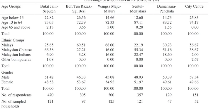
different housing types and pricing. It covered general households (Malaysian only) with various socio-economic, demographic and pre-existing health backgrounds. Table 1 shows the general demographic characteristics of sampled respondents. The sampled respondents include young children (12 years old and below), teenagers and adults (13 to 64 years old) as well as the elderly (65 years old and above) for both male and female. Majority of respondents were Malays and Chinese who were the biggest ethnic groups in KL as well as in Malaysia in general.
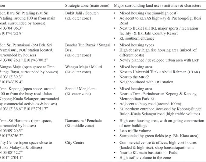
Ambient air quality of KL was identified through air
sampling. In the study, six background/ambient air quality sampling stations were identified, as shown in Figure 1 and Table 2. These stations were proposed to cover all the six strategic planning zones in KL. The air sampling
stations were located in the areas (mostly housing estates) selected for the questionnaire survey. Thus, the ambient air quality of the respondents’ housing areas was measured in the air sampling. The aim of the air quality sampling was to determine the background air quality which was not strongly influenced by any specific source of pollution.
TABLE 1. Demographic background of respondents, by percentage, Kuala Lumpur Percentage of respondents in six zones, KL (%)
Age Groups Bukit
Jalil-Seputeh Bdr. Tun Razak-Sg. Besi Wangsa Maju-Maluri MenjalaraSentul- Damansara- Penchala City Centre Age below 13
Age 13 to 64 Age 65 and above
22.82 75.05 2.13 26.56 72.79 0.66 14.66 82.33 3.00 12.60 87.11 0.28 14.73 83.72 1.55 25.83 74.17 0.00 Total 100.00 100.00 100.00 100.00 100.00 100.00 Ethnic Groups Malays Malaysian Chinese Malaysian Indians Other bumiputeras 25.65 66.38 6.90 1.08 69.51 27.21 3.28 0.00 68.00 16.00 16.00 0.00 22.19 55.34 22.47 0.00 30.23 51.16 18.60 0.00 56.67 38.67 2.00 2.67 Total 100.00 100.00 100.00 100.00 100.00 100.00 Gender Male Female 51.4248.58 46.3353.67 45.0854.92 48.0351.97 50.3949.61 57.3442.66 Total 100.00 100.00 100.00 100.00 100.00 100.00 No. of respondents 470 305 300 357 129 151 No. of sampled households 121 97 125 121 47 52
FIGURE 1. Land use and the location of the six air sampling stations in Kuala Lumpur
TABLE 2. Air quality sampling stations in Kuala Lumpur
Station Strategic zone (main zone) Major surrounding land uses / activities & characters 1. Bdr. Baru Sri Petaling (SM Sri
Petaling, around 100 m from main road, surrounded by houses) N 03º04’06.0”
E101º41’52.8”
Bukit Jalil / Seputeh
(KL outer zone) • Mixed housing (medium/high cost)• Adjacent to KESAS highway & Puchong-Sg. Besi Road
• Next to Bukit Jalil (KL major sports / recreation facility) & Bk. Jalil Country Resort
• KL southern entrance 2. Bdr. Sri Permaisuri (SM Bdr. Sri
Permaisuri, DOE’ station located, surrounded by houses)
N 03º06’26.1” E101º43’00.2”
Bandar Tun Razak / Sungai Besi
(KL outer zone)
• Mixed housing types
• High density, high rise housing area (mixed, of
different costs)
• Newly planned / developed urban area with LRT 3. Wangsa Maju (open space at Tmn.
Bunga Raya, surrounded by houses) N 03º12’39.3”
E101º43’39.4”
Wangsa Maju / Maluri
(KL outer zone) • Mixed housing area• Next to Universiti Tunku Abdul Rahman (UTAR)
• Near to the MRR2
• Neighbourhood with LRT station 4. Tmn. Kepong (open space, around
100 m from the busy road, Jalan Kepong-Kuala Selangor, surrounded by commercial activities & houses) N 03º12’36.6” E101º37’51.7”
Sentul / Menjalara
(KL outer zone) • Mixed housing area• Near to Tmn. Perindustrian Kepong & Kepong
Metropolitan Park KL
• Adjacent to busy road (around 100m)
• KL northern entrance, accessed by Kepong-Sungai
Buloh-Kuala Selangor road (high traffic volume)
5. Tmn. Sri Hartamas (open space, surrounded by houses)
N 03º09’20.5” E101º38’56.2”
Damansara / Penchala
(KL middle zone) • High-cost housing area, with on-going construction of new buildings
• Less traffic volume
• Surrounded by green fields (e.g. Bk. Kiara area)
6. City Centre (open space close to
Bursa Malaysia & offices)
N 03º08’52.7” E101º42’04.1”
City Centre • Commercial centre & offices, high-cost houses
(landed & high-rise), shop houses/apartments
• Near to KL main bus station - Pudu
• High traffic volume in the zone
The location of samples followed the criteria of being at least 100 m from any busy road, not being close to high buildings, and being located in open areas so that they were well exposed to the atmosphere (air flows were unobstructed from most directions) (Harrison 1999; Lau et al. 2009). The advantage of background stations are that they do not present extremes of concentration but represent the background concentration as contributed by many air pollution sources. The majority of people live in background-type areas hence these stations can represent the air quality outside many people’s homes (Harrison 1999; Lau et al. 2009).
With the intention of covering both the wet and dry seasons in a year, air quality sampling was undertaken over twelve sampling days from December 2008 until July 2009. The period of December 2008 to March 2009 was categorised as the wet season (east-north monsoon). Meanwhile, the period of May to July 2009 was categorised as the dry season (west-south monsoon) with a slight encroachment into the transition period between the two seasons (i.e. May). The sampling days were 4 and 13 December 2008 (Thursday and Saturday), 29 and 31 January 2009 (Thursday and Saturday), 6 and 7 March 2009 (Friday and Saturday), 27 and 31 May 2009 (Wednesday
and Sunday), 13 and 15 June 2009 (Saturday and Monday), 12 and 13 July 2009 (Sunday and Monday).
PM10, CO, NO2, SO2 and surface O3 were the five
air pollutants (parameters) measured in the air quality sampling. For the purpose to calculate the air quality levels by using Malaysian Air Pollution Index system (API),
the concentration of each air pollutant was recorded and calculated in average for specific period of time as follows: PM10 and SO2 on 24-hour average; CO on 8-hour averages;
and O3 and NO2 on 1-hour average. In-situ air pollutant analysers were used in the air sampling. GRIMM Aerosol
Spectrometers were used to measure the concentration of ambient PM10. Meanwhile, VRAE Multi Gas Monitors were
used for ambient CO, NO2 and SO2. The concentrations
of the four parameters were recorded every 15 minutes for the whole day. LaMotte Gas Pumps, LaMotte Ozone Sets (sodium arsnite solution 0.5% and DPD#4) and Harts
Spectrophotometer were used to measure the concentration of O3 every hour on the sampling days.
Analyses of the air-related health conditions and air quality of KL were carried out based on the requirement
of indicators established in this study. The API system and
Recommended Malaysian Air Quality Guidelines (RMAQG)
RESULTS AND DISCUSSION
URBAN AIR ENVIRONMENTAL HEALTH INDICATORS
Environmental health indicators have been used globally as a measurement tool in identifying the state of environmental health and its causes. Besides, indicators are also used to evaluate policies or effectiveness of any human plan or action. In this study, local and international related indicators were reviewed before a set of air environmental health indicator was proposed for KL.
In general, for the purpose of indicating urban air quality for environmental health or sustainability, the five pollutants (PM10, O3, CO, SO2, NO2) and API were
usually selected. Table 3 shows the summary of air quality indicators used or proposed by various organisations or studies.
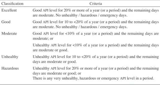
With reference to the various air quality indicators used by various local and international organisations, the air quality indicators formulated in this study were based on the city’s air quality target. The target for KL
is to achieve API values within the good range for 20%
of the year and within moderate range for the remaining 80% of the year (AJM 2006). Four air quality indicators
were formulated in this study, as: (1) Total number (or percentage) of good, moderate, unhealthy, very unhealthy, hazardous or emergency API days in the dry
and wet seasons, as well as during the whole period of study. The KL’s target for air quality was used as the
benchmark to indicate the “excellent” air quality level.
The classifications of air quality levels for this indicator are shown in Table 4. (2) Total number (or percentage) of good, moderate, unhealthy, very unhealthy, hazardous or emergency API days for every single pollutant (i.e. SO2,
NO2, O3, PM10, CO) in the dry and wet seasons, as well as during the whole period of study. The same methodology and classifications as in Indicator 1 were used. The reason for this indicator in addition to the Indicator 1 was to assist in the identification of the potential sources and factors of air pollution which are related to the urban development and activities. (3) Percentage of city’s population living in areas where the ambient air quality was experiencing unhealthy, very unhealthy, hazardous or emergency API level. (4) Percentage of people frequently exposed to air pollution as self-reported.
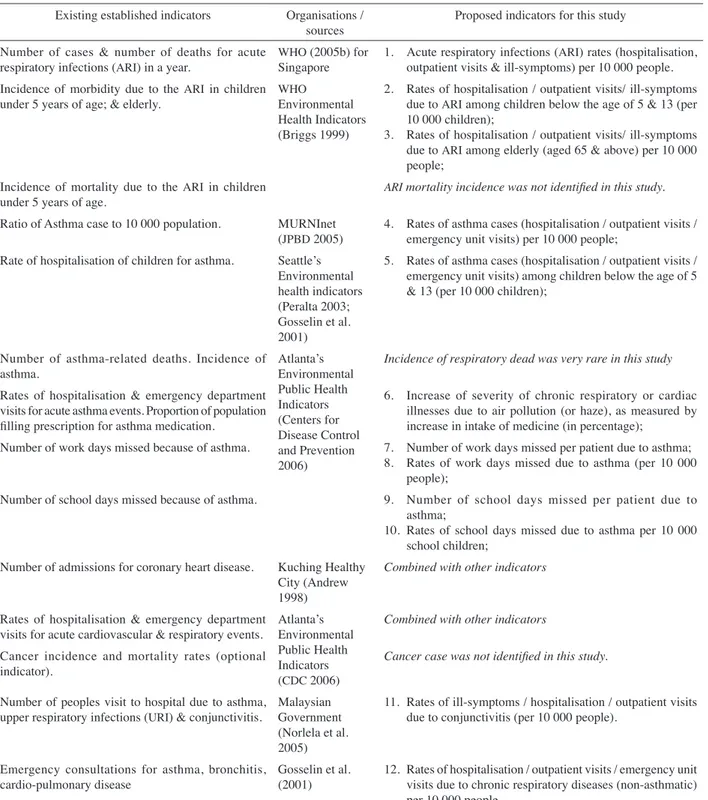
Beside the air quality indicators, air-related health indicators were also identified in this study for KL. Existing
international or local air-related health indicators were formulated by using readily available data especially from the hospital records. In Malaysia, there was no specific set of environmental health indicator that had been established or implemented. However, there are some Healthy Cities initiatives or projects which are on-going in Malaysian cities or towns, which are Healthy City Johor Bahru since 1994 (Rozlan 1998;Daud 2002),Malacca (Pereira & Mohd Nordin 2004), Healthy Cities Kuching since 1994, and subsequently in other major towns in Sarawak (Rozlan 1998). In general, these healthy cities projects or initiatives were aiming for a better city environment with good features such as higher quality of life, safety,
TABLE 3. Summary of air quality indicators
Organisations / studies Air quality indicators
WHO Environmental Health Indicators
(Briggs 1999) mean annual or percentile concentration of 6 major ambient air pollutants, i.e. O3, CO, PM, SO2, NO2 and Pb. Briggs (1999) and Gosselin et al. (2001) number of days/hours in excess of air pollution standard
New Zealand (Hambling & Slaney 2007) number of days exceeding WHO guidelines for the major 5 pollutants, i.e. PM10, O3, SO2, NO2, and CO
Seattle, Washington, US (Peralta 2003) number of “good” air quality days in the calendar year
Atlanta (CDC 2006) annual high levels of criteria pollutants: PM10, O3, SO2, NO2, CO and Pb WHO’s Healthy Cities Movement
(Barton & Tsourou 2000) atmospheric pollution based on the pollution level of SOPb and dust 2, NO2, CO, O3, US EPA (2003) number and percentage of days that metropolitan statistical areas have
AQI values greater than 100; number of people living in areas with O3 (8 hour) and PM2.5 levels above the NAAQS
Gosselin et al. (2001) for U.S.-Mexico
region percentage of children living in counties in which air quality standards are exceeded air quality standard Kuching Healthy City, Malaysia
(Andrew 1998) number of pollution free days in a month; number of areas with air pollution in a month Selangor Sustainable Development
Indicators, Malaysia (Selangor State Government 2001)
total number of day with API exceeding unhealthy level; SO & NO pollution level in Petaling Jaya & Shah Alam; small particulate matter & PM10 concentration
Malaysian Sustainable City Award
cleanliness, harmony, provided with amenities, and well-planned. Besides, there are few initiatives of sustainable indicators and environmental targets in Malaysia which cover some aspects of environmental health.
The first and second columns of Table 5 show some of the air-related health indicators established or used by local and international organisations. The third column shows the proposal of air-related health indicators for this study. Number of ARI ill-symptom cases (ARI incidence)
is measured based on self-reported frequency of getting
ARI symptoms by respondents, which suffered for a period
within 14 days per case. Any illness experienced for a period within 14 days was considered as an episode/case of acute illness. This is similar to the definition used by the Institute of Public Health, Malaysia. The majority of
ARI episodes lasted within duration of 14 days and was an
acute, self limiting condition (IPH 2008). AIR QUALITY INDICATION
The results of the four air quality indicators are discussed briefly as follow. Air quality (measured in API) in KL was
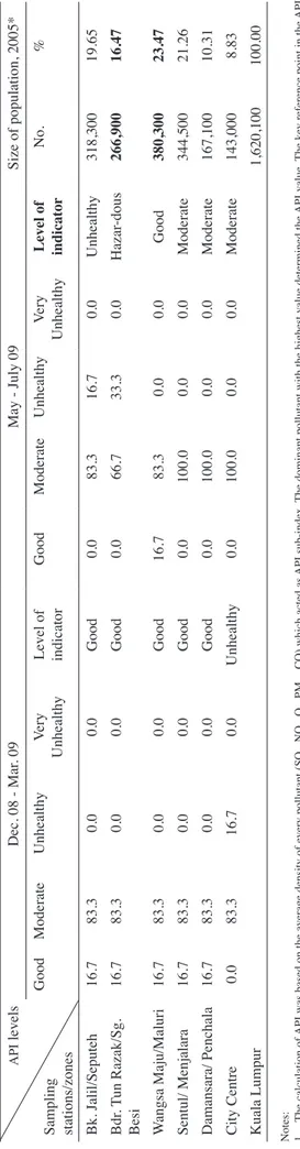
more polluted in the period of May-July 2009 (dry season) as compared to the period of December 2008-March 2009 (wet season) in most of the zones, except for the City Centre (Table 6). It showed that wet season with more rainfall could reduce the concentration of air pollutants in the air. The most polluted area in KL was Bandar Tun
Razak/Sungai Besi zone (“hazardous” during May-July 2009), and followed by Bukit Jalil/Seputeh (“unhealthy” level during May-July 2009). The best air quality area was Wangsa Maju/Maluri (“good” level). An unhealthy (or higher levels) day was indicated by the concentration of most polluted pollutant which was higher than the standard in RMAQG.
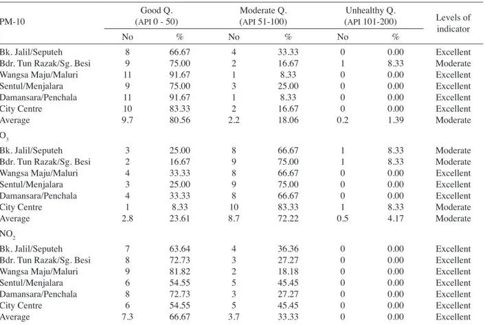
Among the five pollutants, KL was more polluted
by O3 and PM10 (Tables 7). Nitrogen Dioxide (NO2) concentrations were showing either good or moderate API
levels for all the six strategic planning zones. Meanwhile,
CO and SO2 concentrations were showing good API levels
for every sampling day in all the six zones. PM10 is a parameter consists of various types of pollutants including gases and dusts. In Malaysia, stationary sources (including industries & power plants) contributed almost 90% of the emissions of PM10 (EPU 2006). Ozoneis the secondary
pollutant formed by volatile organic compounds (VOC)
and nitrogen dioxide (NO2) with the existence of sunlight. Thus, with an increase in O3 concentrations, the other pollutants (especially the NO2) decreased at the same time. VOC is produced from combustion of fossil fuels
(in industries and vehicles) and incineration, evaporation of liquid fuel and leakage from pressurized system (e.g. natural gas and methane). Meanwhile, NO2 was mainly produced by mobile sources (EPU 2006). The findings
showed that air pollution in KL was mainly contributed by
mobile sources (especially motor vehicles) and stationary sources (especially industries).
The most polluted area, Bandar Tun Razak/Sungai Besi zone consisted of 16.47% of KL population. The
biggest population group (23.47%) was living in the most healthy air quality zone, i.e. Wangsa Maju/Maluri (Table 6). Table 8 shows that there were 5% to 15% of respondents in
KL (among the six zones) who were frequently exposed to
air pollution due to their presence in air polluted areas such as factories, workshops, busy roadsides and construction sites. Damansara/Penchala zone had the highest percentage of respondents (14.73%) who were frequently present in air polluted areas. It was due to the surrounding areas of Damansara which were undergoing active property construction activities. The construction activities were adjacent to some houses, offices, schools, parks and main roads.
AIR-RELATED HEALTH INDICATION
This paper is not intended to discuss results of all the air-related indicators in detail. Out of the 13 air-air-related health indicators, only the selected findings of the Indicators 1 and
TABLE 4. Classifications of air quality level for Indicator 1 and 2
Classification Criteria
Excellent Good API level for 20% or more of a year (or a period) and the remaining days are moderate. No unhealthy / hazardous / emergency days.
Good Good API level for 10 to <20% of a year (or a period) and the remaining days are moderate. No unhealthy / hazardous / emergency days.
Moderate Good API level for <10% of a year (or a period) and the remaining days are moderate; or
Unhealthy API level for <10% of a year (or a period) and the remaining days are moderate or good.
Unhealthy Unhealthy API level for 10 to <20% of a year (or a period) and the remaining days are moderate or good.
Hazardous Unhealthy API level for 20% or more of a year (or a period) and the remaining days are moderate or good; or
TABLE 5. Indicators for air-related diseases or ill-symptoms Existing established indicators Organisations /
sources Proposed indicators for this study Number of cases & number of deaths for acute
respiratory infections (ARI) in a year. WHO (2005b) for Singapore 1. Acute respiratory infections (ARI) rates (hospitalisation, outpatient visits & ill-symptoms) per 10 000 people. Incidence of morbidity due to the ARI in children
under 5 years of age; & elderly. WHO Environmental Health Indicators (Briggs 1999)
2. Rates of hospitalisation / outpatient visits/ ill-symptoms due to ARI among children below the age of 5 & 13 (per 10 000 children);
3. Rates of hospitalisation / outpatient visits/ ill-symptoms due to ARI among elderly (aged 65 & above) per 10 000 people;
Incidence of mortality due to the ARI in children
under 5 years of age. ARI mortality incidence was not identified in this study. Ratio of Asthma case to 10 000 population. MURNInet
(JPBD 2005) 4. Rates of asthma cases (hospitalisation / outpatient visits / emergency unit visits) per 10 000 people; Rate of hospitalisation of children for asthma. Seattle’s
Environmental health indicators (Peralta 2003; Gosselin et al. 2001)
5. Rates of asthma cases (hospitalisation / outpatient visits / emergency unit visits) among children below the age of 5 & 13 (per 10 000 children);
Number of asthma-related deaths. Incidence of
asthma. Atlanta’s Environmental
Public Health Indicators (Centers for Disease Control and Prevention 2006)
Incidence of respiratory dead was very rare in this study
Rates of hospitalisation & emergency department visits for acute asthma events. Proportion of population filling prescription for asthma medication.
6. Increase of severity of chronic respiratory or cardiac illnesses due to air pollution (or haze), as measured by increase in intake of medicine (in percentage);
Number of work days missed because of asthma. 7. Number of work days missed per patient due to asthma; 8. Rates of work days missed due to asthma (per 10 000
people);
Number of school days missed because of asthma. 9. Number of school days missed per patient due to asthma;
10. Rates of school days missed due to asthma per 10 000 school children;
Number of admissions for coronary heart disease. Kuching Healthy City (Andrew 1998)
Combined with other indicators
Rates of hospitalisation & emergency department
visits for acute cardiovascular & respiratory events. Atlanta’s Environmental Public Health Indicators (CDC 2006)
Combined with other indicators
Cancer incidence and mortality rates (optional
indicator). Cancer case was not identified in this study.
Number of peoples visit to hospital due to asthma,
upper respiratory infections (URI) & conjunctivitis. Malaysian Government (Norlela et al. 2005)
11. Rates of ill-symptoms / hospitalisation / outpatient visits due to conjunctivitis (per 10 000 people).
Emergency consultations for asthma, bronchitis,
cardio-pulmonary disease Gosselin et al. (2001) 12. Rates of hospitalisation / outpatient visits / emergency unit visits due to chronic respiratory diseases (non-asthmatic) per 10 000 people.
13. Rates of hospitalisation / outpatient visits / emergency unit visits due to cardiac diseases (per 10 000 people). Annual number of hospital admissions for respiratory
diseases Environmental Health Indicators
for New Zealand (Hambling & Slaney 2007)
Incidence of respiratory / cardiovascular dead was very rare in this study.
Annual number of hospital admissions for diseases of the circulatory system; & asthma (per 100 000 population)
Annual mortality rate due to respiratory diseases / cardiovascular diseases
Annual prescription rate for asthma medication (per
100 000 population) Combined with other indicators
Note: Rates of illness in the proposed indicators were calculated as ratios of illness cases among respondents to total number of respondents (or any segment of respondents) which may consist of repeated cases of the same respondent.
TABLE
6.
Air Quality Indicator 1 (percentage of days for each level of
API
, for the periods of
December 2008-March 2009 and May-July 2009), and
Air Quality Indicator 3 (size of population)
API levels Sampling stations/zones Dec. 08 - Mar . 09 May - July 09 Size of population, 2005* Good Moderate Unhealthy Very Unhealthy Level of indicator Good Moderate Unhealthy Very Unhealthy Level of indicator No. % Bk. Jalil/Seputeh 16.7 83.3 0.0 0.0 Good 0.0 83.3 16.7 0.0 Unhealthy 318,300 19.65 Bdr . T un Razak/Sg. Besi 16.7 83.3 0.0 0.0 Good 0.0 66.7 33.3 0.0 Hazar -dous 266,900 16.47 W angsa Maju/Maluri 16.7 83.3 0.0 0.0 Good 16.7 83.3 0.0 0.0 Good 380,300 23.47 Sentul/ Menjalara 16.7 83.3 0.0 0.0 Good 0.0 100.0 0.0 0.0 Moderate 344,500 21.26 Damansara/ Penchala 16.7 83.3 0.0 0.0 Good 0.0 100.0 0.0 0.0 Moderate 167,100 10.31 City Centre 0.0 83.3 16.7 0.0 Unhealthy 0.0 100.0 0.0 0.0 Moderate 143,000 8.83 Kuala Lumpur 1,620,100 100.00 Notes: 1. The calculation of API was based on the average density of every pollutant (SO 2 , NO 2 , O3 , PM 10 , CO) which acted as API sub-index. The dominant pollutant with the highest value determined the API value. The key reference point in the API
systems was the index value of 100 (the “safe” limit), which was based on the air quality guidelines for the specific air pollutants concerned as referred to RMAQG.
2.
Good level (API 0 – 50); moderate level (API 51 – 100); unhealthy level (API 101 – 200); very unhealthy level (API 201 – 300); hazardous level (API 301 – 500); emer
gency level (API >500).
Source: Ling et al. 2010b; *
CHKL
TABLE 7. Air Quality Indicator 2 - number of days for each category of API for PM10, O3, NO2, CO and SO2, December 08-July 2009
PM-10 (API 0 - 50)Good Q. Moderate Q. (API 51-100) (API 101-200)Unhealthy Q. Levels of indicator
No % No % No %
Bk. Jalil/Seputeh Bdr. Tun Razak/Sg. Besi Wangsa Maju/Maluri Sentul/Menjalara Damansara/Penchala City Centre Average 8 9 11 9 11 10 9.7 66.67 75.00 91.67 75.00 91.67 83.33 80.56 4 2 1 3 1 2 2.2 33.33 16.67 8.33 25.00 8.33 16.67 18.06 0 1 0 0 0 0 0.2 0.00 8.33 0.00 0.00 0.00 0.00 1.39 Excellent Moderate Excellent Excellent Excellent Excellent Moderate O3 Bk. Jalil/Seputeh Bdr. Tun Razak/Sg. Besi Wangsa Maju/Maluri Sentul/Menjalara Damansara/Penchala City Centre Average 3 2 4 3 4 1 2.8 25.00 16.67 33.33 25.00 33.33 8.33 23.61 8 9 8 9 8 10 8.7 66.67 75.00 66.67 75.00 66.67 83.33 72.22 1 1 0 0 0 1 0.5 8.33 8.33 0.00 0.00 0.00 8.33 4.17 Moderate Moderate Excellent Excellent Excellent Moderate Moderate NO2 Bk. Jalil/Seputeh Bdr. Tun Razak/Sg. Besi Wangsa Maju/Maluri Sentul/Menjalara Damansara/Penchala City Centre Average 7 8 9 6 8 6 7.3 63.64 72.73 81.82 54.55 72.73 54.55 66.67 4 3 2 5 3 5 3.7 36.36 27.27 18.18 45.45 27.27 45.45 33.33 0 0 0 0 0 0 0 0.00 0.00 0.00 0.00 0.00 0.00 0.00 Excellent Excellent Excellent Excellent Excellent Excellent Excellent
Note: All the 6 sampling stations/zones showed a good level for CO and SO2 concentrations with API below 50 for the period of December 2008 to July 2009. Thus, this
indicator showed “excellent” levels for CO and SO2 concentrations in KL.
TABLE 8. Air Quality Indicator 4 - percentage of people frequently exposed to air pollution as self-reported
Percentage of respondents in 6 zones, KL (%) Bukit Jalil/
Seputeh Razak/Sg. BesiBdr. Tun Wangsa Maju/Maluri MenjalaraSentul/ Damansara/ Penchala City Centre
Exposed 10.26 5.33 5.61 7.47 14.73 8.05
None 89.74 94.67 94.39 92.53 85.27 91.95
Total 100.00 100.00 100.00 100.00 100.00 100.00
4 are discussed in this paper. Acute Respiratory Infection (ARI) was used as indicator in Indicator 1, and asthma
was used in Indicator 4. Table 9 shows the rates of ARI
ill-symptoms, ARI outpatient visits and asthmatic outpatient
visits cases in KL. The results indicated that the higher
rates of ARI ill-symptoms were reported for the period of
October 2008 to March 2009 (wet season) as compared to the period of April to July 2009 (dry season), except for Bukit Jalil-Seputeh and Bandar Tun Razak-Sungai Besi zones. The wet season (October 2008 to March 2009), however, had recorded with a better ambient air quality level as compared to the period of April to July 2009 (Tables 6). It contradicted the common assumption that respiratory cases should be higher in the dry season where ambient air quality is generally more polluted than in the
wet season. This was because air-related illness (respiratory health) was not only influenced by ambient air quality but also by the rate of the individual respondent’s exposure to air pollutants, the weather factor, or climate change. Besides, there are other factors that potentially affect respiratory health, for example, the impact of allergens and moulds, age, and socio-economic factor (Gouveia & Maisonet 2006; Janssen & Mehta 2006; Utell et al. 2006). Change of temperature and excessive rainfall impact other health-relevant factors such as allergens and moulds (Ayres et al. 2009).
Based on the rates of ARI outpatient visits, three
areas i.e. Wangsa Maju/Maluri, Sentul/Menjalara and Damansara/Penchala zones were showing higher rates in the period of October 2008 to March 2009 as compared
to the dry season. However, the City Centre, Bandar Tun Razak/Sungai Besi and Bukit Jalil/Seputeh zones were showing slightly higher rates of ARI outpatient visits during
the period of April to July 2009 as compared to the period of October 2008 to March 2009. The rates of asthmatic outpatient visits were higher in the period of October 2008 to March 2009 as compared to the dry season for Wangsa Maju/Maluri, the City Centre and Bukit Jalil/Seputeh zones. However, Sentul/Menjalara, Damansara/Penchala and Bandar Tun Razak/Sungai Besi zones were showing higher rates in the period of April to July 2009 (Table 9). It implies that respiratory illness (ARI or asthmatic) rates were
not always higher during the dry season (more polluted) as compared to the wet season.
As shown in Table 6, Bandar Tun Razak/Sungai Besi, Bukit Jalil/Seputeh and the City Centre zones had a higher number of unhealthy days as compared to the other zones. However, the higher percentages of ARI and asthma cases were identified in the City Centre, Bukit Jalil/Seputeh and Wangsa Maju/Maluri zones. Bandar Tun Razak/Sungai Besi zone with the highest number of unhealthy days was identified with lower rates of ARI and asthma cases (Table
9). Thus, positive relationship between selected air-related health indicators and ambient air quality among the six strategic planning zones were not developed.
However, by looking at the relationship between ARI
or asthma cases, and density of the areas/zones, it showed a trend of higher ARI and asthma cases at the higher density
zones (Table 9). The City Centre, Bukit Jalil/Seputeh and Wangsa Maju/Maluri zones were identified with higher density of population and shopping floor space as compared to other zones in KL. Meanwhile, these zones also showed
higher rates of ARI and asthma cases.
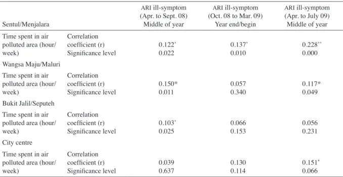
Table 10 shows the results of relationship tests between air-related health indicator (rates of ARI ill-symptoms)
and respondent’s exposure to air pollutant (duration of time spent by respondents in air polluted areas). The relationships were tested by using the Spearman rank correlation method. The relationships were significant at most of the zones, except for Damansara/Penchala and Bandar Tun Razak/Sungai Besi zones which were not significant even at the 0.10 level. Even though the statistical relationships showed a significant but weak correlation, it implies that people’s health is potentially influenced
TABLE 9. Rates of ARI ill-symptoms, ARI outpatients and asthmatic outpatients,
population density, and shopping floor space, Kuala Lumpur
Respiratory cases Number of cases per 100 people Population
density, 2005 (person per km2)*
Shopping fl.
space, 2010 (‘000 m2 per km2)* Oct. 08 to Mar. 09 Apr. to July 09 Total
City Centre 8 038 111.21 ARI ill-symptom ARI outpatient Asthmatic outpatient 82 29 4.0 68 30 1.3 150 59 5.3 Bukit Jalil/Seputeh 7 363 25.85 ARI ill-symptom ARI outpatient Asthmatic outpatient 49 29 0.9 53 30 0.6 102 59 1.5 Wangsa Maju/Maluri 8 163 18.42 ARI ill-symptom ARI outpatient Asthmatic outpatient 39 30 2.3 38 25 2.0 77 55 4.3 Sentul/Menjalara 7 473 21.11 ARI ill-symptom ARI outpatient Asthmatic outpatient 33 24 0.6 22 14 0.6 55 38 1.2
Bdr. Tun Razak / Sg. Besi 6 483 10.50
ARI ill-symptom ARI outpatient Asthmatic outpatient 24 13 0.3 32 19 1.0 56 32 1.3 Damansara/Penchala 3 521 5.85 ARI ill-symptom ARI outpatient Asthmatic outpatient 16 13 0.0 14 7 1.6 30 20 1.6 Source: * adapted from AJM 2006
by the exposure level to air pollution. The results were also showing that people were not only receiving health impact from the ambient air quality in their housing areas (as indicated in the air quality indicators) but also from the other areas such as at workplaces.
In most of the strategic planning zones, the significant relationships between air-related health and exposure were identified in the middle of the year (dry season) only (Table 10), but not for the wet season. It might be due to the reason that air quality in the air polluted areas had been improved due to the precipitation effects during the wet season. Concentrations of air pollutants were reduced by washout and rainout effects. Thus, during the wet season, respondents potentially inhaled less air pollutants at air polluted areas.
CONCLUSION
In conclusion, by using the urban air environmental health indicators, KL was identified as having a moderate level
of air quality. The cleanest zone was Wangsa Maju/Maluri (good air quality level) and the most polluted zone was Bandar Tun Razak/Sungai Besi (hazardous level during the dry season). There were unhealthy days in Bukit Jalil/ Seputeh, Bandar Tun Razak/Sungai Besi and the City Centre zones. Thus, a total population of 728 200 or 45% of the total population of KL was potentially exposed to the
unhealthy air quality in their living areas (Table 6). Analysis on the related illnesses showed that air-related illness was higher in the more developed or higher density zones/areas, and higher among the respondents
with higher rate of exposure to air pollution (longer duration of time spent in air polluted areas). However, the ambient air quality levels were not significantly correlated to the rates of air-related illnesses among respondents.
As a recommendation from this study, all the urban developments and activities should be well managed in order to improve air quality and air health of an area. Special attention should be given to the higher density zones, and air polluted areas such as industries, which are potentially generating more negative impacts on human health. Simple land use zoning to segregate the polluting activities from the housing areas for the purpose to improve ambient air quality in the housing area is not going to improve human health effectively. It is because people are also exposed to air pollution in their workplace and along the roads.
ACKNOWLEDGEMENT
The authors would like to thank Research Management Institute (RMI), Universiti Teknologi MARA (UiTM)
for funding the study, and Department of Environment Malaysia, City Hall of Kuala Lumpur and Assoc. Prof. Dr. Mohd Talib Latif from Universiti Kebangsaan Malaysia for providing information and data.
REFERENCES
Akitek Jururancang Malaysia Sdn. Bhd. (AJM). 2006. Kuala Lumpur Local Plan–Findings Report.
Andrew Kiyu. 1998. Developing indicators for Healthy City Kuching. Second National Conference on Healthy Cities. Kuala Lumpur, 14-15 July.
TABLE 10. Relationships between duration of time spent in air polluted areas and
rates of ARI ill-symptoms of respondents
Sentul/Menjalara ARI ill-symptom (Apr. to Sept. 08) Middle of year ARI ill-symptom (Oct. 08 to Mar. 09) Year end/begin ARI ill-symptom (Apr. to July 09) Middle of year Time spent in air
polluted area (hour/ week) Correlation coefficient (r) Significance level 0.122 * 0.022 0.137 * 0.010 0.228 ** 0.000 Wangsa Maju/Maluri
Time spent in air polluted area (hour/ week)
Correlation
coefficient (r)
Significance level 0.150*0.011 0.0570.340 0.117*0.049 Bukit Jalil/Seputeh
Time spent in air polluted area (hour/ week) Correlation coefficient (r) Significance level 0.103 * 0.025 0.0660.153 0.0560.231 City centre Time spent in air polluted area (hour/ week) Correlation coefficient (r) Significance level 0.0390.637 0.1300.114 0.151 * 0.066
Note: •significant at the 0.10 level
* significant at the 0.05 level. ** significant at the 0.01 level.
Ayres, J.G., Forsberg, B., Annesi-Maesano, I., Dey, R., Ebi, K.L., Helms, P.J., Medina-Ramon, M., Windt, M. & Forastiere, F. 2009. Climate change and respiratory disease: European respiratory society position statement. European Respiratory
Journal 34: 295-302.
Barton, H. & Tsourou, C. 2000. Health urban planning - a
WHO guide to planning for people. Geneva: World Health
Organisation (WHO).
Botkin, D.B. & Keller, E.A. 2003. Environmental Science – Earth
as a Living Planet. U.S.: John Wiley & Sons, Inc.
Briggs, D. 1999. Environmental Health Indicators: Framework
and Methodologies. Geneva: WHO, Sustainable Development
and Healthy Environments.
Centers for Disease Control and Prevention (CDC). 2006.
Environmental Public Health Indicators. Alanta, Georgia.
(on line) http://www.cdc.gov/nceh/ (21 June 2007). Christiani, D.C. & Woodin, M.A. 2002. Urban and transboundary
air pollution. In Life Support – the Environment and Human
Health, edited by McCally, M. 15-37. London: The MIT
Press.
City Hall of Kuala Lumpur (CHKL). 2009. Kuala Lumpur City Plan 2020. (on line) http://klcityplan2020.dbkl.gov.my (20 November 2009).
Dasimah Omar & Oliver Ling Hoon Leh. 2006. Sustainable Development Planning: Public Participation Programme in the Development Plan Preparation Process (Case Studies of Sabak Bernam District Local Plan & Kuala Lumpur Structure Plan). International Conference in Built Environment in the
21st Century (ICiBE). Kuala Lumpur, 13-15 June.
Daud A Rahim. 2002. Healthy city: Johor Bahru experience.
NCD Malaysia 1(3): 4-8.
Economic Planning Unit (EPU). 2006. Ninth Malaysia Plan
2006-2010. Putrajaya: Prime Minister’s Department. (on
line) www.epu.jpm.my/rm9/ (1 April 2006)
Gosselin, P., Furgal, C. & Ruiz, A. 2001. Environmental public health indicators for the U.S. – Mexico border region – concept document. (on line) http://www.fep.paho.org/ (21 August 2008).
Gouveia, N.C. & Maisonet, M. 2006. Health effects of air
pollution: an overview. In WHO Regional Office for Europe.
Air quality guidelines – global update 2005: particular matter, ozone, nitrogen dioxide and sulphur dioxide, pp.
87-110.
Hambling, T. & Slaney, D. 2007. Environmental Health Indicators for New Zealand: annual report 2007. (on line) http://www. surv.esr.cri.nz/ (24 February 2008).
Harrison, R.M. 1999. Measurement of concentration of air pollutants. In Air Pollution and Health, edited by Holgate, S.T., Samet, J.M., Koren, H.S. & Maynard, R.L. San Diego: Academic Press.
Institute for Public Health (IPH). 2008. The third national health
and morbidity survey (NHMS III) 2006. Kuala Lumpur:
Ministry of Health Malaysia.
Jabatan Perancangan Bandar & Desa (JPBD). 2005. Garis
panduan & manual penggunaan petunjuk bandar Malaysia (MURNInet). Kuala Lumpur: JPBD.
Jabatan Perancangan Bandar & Desa (JPBD). 2006. National
Urbanisation Policy (DPN). Kuala Lumpur, Malaysia.
Janssen, N. & Mehta, S. 2006. Human exposure to air pollution. In WHO-Europe. Air quality guidelines – global update
2005: particular matter, ozone, nitrogen dioxide and sulphur dioxide, pp. 61-86.
Kinney, P.L. & O’Neill, M.S. 2006. Environmental equity. In WHO-Europe. Air Quality Guidelines – Global Update 2005:
Particular Matter, Ozone, Nitrogen Dioxide and Sulphur Dioxide, pp. 135-152.
Lau, J., Hung, W.T. & Cheung, C.S. 2009. Interpretation of air quality in relation to monitoring station’s surroundings.
Atmospheric Environment 43: 769-777. (on line) www.
elsevier.com (5 March 2009).
Ling, O.H.L., Ting, K.H., Shaharuddin A., Kadaruddin A. & Yaakob M.J. 2010a. Urban growth and air quality in Kuala Lumpur city, Malaysia. EnvironmentAsia3 (2): 123-128. Ling, O.H.L., Ting, K.H., Shaharuddin A., Kadaruddin A.
& Yaakob M.J. 2010b. Air quality and human health in urban settlement: case study of Kuala Lumpur city. 2010
International Conference on Science and Social Research (CSSR 2010), pp. 516-521.
Ling, O.H.L., Ting, K.H., Dasimah O., Jamalunalaili A. & Tee, S.F. 2010c. Transit oriented neighbourhood for better environmental health. 2010 International Conference on
Science and Social Research (CSSR 2010), pp. 522-527.
Norela, S., Sadah, M.S. & Mohd Talib, L. 2008. Effects of haze on human health in Malaysia: case study in 2005. In Scientific
report on the haze event in Peninsular Malaysia in August 2005. Part II: physical and social aspects, edited by Mahmud,
M. & Abdullah, M. Malaysia: Department of Environment. Peralta, G.L. 2003. Draft guide to essential environmental health
functions. Manila: WHO - Western Pacific Regional Office.
(on line) http://www.dph.gov.my (27 March 2008). Pereira J.J. & Mohd Nordin Hasan. 2004. Sustainable
development indicators: an overview of ongoing initiatives in Malaysia. In Indicators of sustainable development:
assessing changes in environmental conditions, edited by A.
Latiff, Pereira, J.J., A. Hezri Adnan & A.A. Aldrie. pp. 3-13. Bangi: LESTARI, UKM.
Rafia Afroz, Mohd Nasir H. & Noor Akma I. 2003. Review of
air pollution and health impacts in Malaysia. Environmental Research 92: 71-77.
Romieu, I. 1999. Epidemiological studies of health effects arising from motor vehicle air pollution.In Urban Traffic Pollution, edited by Schwella, D. & Zali, O. pp. 9-70. London & New York: E & FN Spon.
Rozlan Ishak. 1998. The progress of healthy cities programme in Malaysia. Working paper, Second National Conference on
Healthy Cities. Kuala Lumpur, 14-15 July.
Saldiva, P.H.N., Künzli, N. & Lippmann, M. 2006. Ozone. In WHO-Europe. Air Quality Guidelines – Global Update 2005:
Particular Matter, Ozone, Nitrogen Dioxide and Sulphur Dioxide, pp. 307-330.
Selangor State Government. 2001. Strategi pembangunan
mampan & agenda 21 Selangor: Agenda 21 Selangor. Bangi:
LESTARI, UKM.
Tan, H.C.P., Pereira, J.J., Shaharudin Idurs & Abdul Samad Hadi. 2006. Tracking Sustainability Bandar Lestari – Environmental Award. Bangi: LESTARI, UKM.
United Nations (UN) - Department of Economic and Social Affairs, Population Division. 2001. World Population
Monitoring 2001 – Population, environment and development.
New York: UN.
United States Environmental Protection Agency (US EPA). 2003.
EPA’s draft report on the environment 2003. (on line) http://
www.epa.gov (21 August 2008).
United States Environmental Protection Agency (US EPA). 2007. Children’s environmental health: 2007 Highlights.
(on line) http://yosemite.epa.gov/ochp/ochpweb.nsf/ (27 March 2008).
Utell, M.J., Mehta, S. & Frampton, M.W. 2006. Determinants of susceptibility. In Air quality guidelines – global update
2005: particular matter, ozone, nitrogen dioxide and sulphur dioxide, WHO-Europe. pp. 111-134.
World Health Organisation (WHO). 2005a. Particulate matter air pollution: how it harms health. Fact sheet EURO/04/05, Berlin, Copenhagen, Rome, 14 Apr. 05. (on line) http://www. euro.who.int/document/ (27 March 2008).
World Health Organisation (WHO). 2005b. Singapore -
environmental health country profile as of April 28, 2005. (on
line) http://www.wpro.who.int/NR/ (24 February 2008). World Health Organisation - Europe (WHO-Europe). 2007. (on
line) http://www.euro.who.int/ eprise/main/WHO/Progs/ HEP/ 20030612_1 (6 June 2007).
World Health Organisation (WHO). 2008. Air quality and health. (on line) http://www.euro.who.int/air (27 March 2008).
Oliver Ling Hoon Leh & Ting Kien Hwa
Faculty of Architecture, Planning & Surveying (FSPU) Universiti Teknologi MARA (UiTM)
40450 Shah Alam Selangor D.E. Malaysia
Shaharuddin Ahmad, Kadaruddin Aiyub & Yaakob Mohd Jani Faculty of Social Sciences and Humanities
Universiti Kebangsaan Malaysia 43600 UKM, Bangi, Selangor D.E. Malaysia
*Corresponding author; email: oli761@yahoo.com Received: 27 April 2011