UNIVERSITÀ DEGLI STUDI DI NAPOLI
“L’ORIENTALE”
D
IPARTIMENTOA
SIA,
A
FRICA EM
EDITERRANEOISMEO
A
SSOCIAZIONEI
NTERNAZIONALE DIS
TUDISUL
M
EDITERRANEO E L’O
RIENTEDigital offprint from described in t he Cont ribut ion.
ISMEO
A
SSOCIAZIONEI
NTERNAZIONALE DIS
TUDISUL
M
EDITERRANEO E L’O
RIENTEDARIOSH STUDIES II
PERSEPOLIS AND ITS SETTLEMENTS:
TERRITORIAL SYSTEM AND IDEOLOGY
IN THE ACHAEMENID STATE
edited by
UNIVERSITÀ DEGLI STUDI DI NAPOLI “L’ORIENTALE”
D
IPARTIMENTOA
SIA,
A
FRICA EM
EDITERRANEOSeries Minor
LXXVIII
DARIOSH STUDIES II
PERSEPOLIS AND ITS SETTLEMENTS:
TERRITORIAL SYSTEM AND IDEOLOGY
IN THE ACHAEMENID STATE
edited by
G
IANP
IETROB
ASELLOand A
DRIANOV.
R
OSSISeries Minor
LXXVIII
Volume pubblicato nell’ambito dei Programmi di ricerca di rilevante interesse nazionale diretti da A.V. Rossi PRIN 2005105580, PRIN 2007ZKPPSM e PRIN 2009JHSEE7.
Volume published in the framework of the Research Projects of National Interest directed by A.V. Rossi
PRIN 2005105580, PRIN 2007ZKPPSM and PRIN2009JHSEE7.
ISSN 1824-6109 ISBN 978-88-6719-034-8
© Università degli Studi di Napoli “L’Orientale” <www.unior.it>
Distributed by:
Dipartimento Asia, Africa e Mediterraneo e-mail: <[email protected]>
Questo volume è stato stampato presso
IL TORCOLIERE – Officine Grafico-Editoriali d’Ateneo
C
ONTENTSGIAN PIETRO BASELLO &ADRIANO V.ROSSI
Foreword... VII
LINGUISTICS AND PHILOLOGY GIAN PIETRO BASELLO
Doorknobs, Nails or Pegs? The Function(s) of the Elamite and Achaemenid Inscribed Knobs...1
MARIA CARMELA BENVENUTO
Self-discipline and the Exercise of Power. Linguistic Evidence in the Royal Achaemenid Inscriptions (DNb and XPl) ...67
CLAUDIA CIANCAGLINI
Outcomes of the Indo-Iranian Suffix *-ka- in Old Persian and Avestan...91
ELA FILIPPONE
DPd/DPe and the Political Discourse of King Darius...101
GRAZIA GIOVINAZZO
Gli artigiani della pietra a Persepoli... 121
ANTONIO PANAINO
No Room for the “Paradise”? About Old Persian <pa-ra-da-ya-da-a-ma>...139
FLAVIA POMPEO
Some Syntactic and Semantic Remarks on XPl 30-31 ...155
CLAUDIA ROMAGNUOLO
hutta- and kuši- in Achaemenid Elamite...183
ARCHAEOLOGY AND HISTORY
MARIA LETIZIA AMADORI,SARA BARCELLI,MARCO GALUPPI, PAOLO PALLANTE & GIULIANA
RAFFAELLI
“From Palace to Town”: indagini archeometriche su ceramiche provenienti dagli scavi italo-iraniani nei siti di Persepolis West e Pasargadae (Fars, Iran)...199
ALIREZA ASKARI CHAVERDI &PIERFRANCESCO CALLIERI
RÉMY BOUCHARLAT,TIJS DE SCHACHT &SÉBASTIEN GONDET
Surface Reconnaissance in the Persepolis Plain (2005-2008). New Data on the City Organisation and Landscape Management ...249
BIRGIT COSTAZZA
The Funerary Ritual as Rite of Passage...291
ROBERTO DAN
Nails in the Wall: The sikkatu in Urartian Toreutic Production...301
FRANCESCO FRANZESE & ANDREA GENITO
Towards an Archaeological Map of Fars. Work, Methods and Strategies: Preliminary Aspects ...313
ANDREA GARIBOLDI
La circolazione della moneta imperiale achemenide ...339
BRUNO GENITO
An “Achaemenid” Capital of the Imperial Periphery: Zrānka / Drangiana / Sistan ...365
GIOLJ FRANCESCO GUIDI, SHAHRAM RAHBAR,SAEID RAHMATI,REZA SHEIKHOLESLAMI, MARYAM SOLEIMANI,GIORGIO TROJSI &AZAM ZARE
Diagnostic Survey of Persepolis Terrace. Preliminary Results ...387
WALTER KUNTNER &SANDRA HEINSCH
The Fortress of Aramus in Achaemenid Times...403
PAOLO OGNIBENE
Ai confini settentrionali dell’Iran achemenide...417
ANDREA PIRAS
Ethnography of Communication in Achaemenid Iran: The Royal Correspondence ...431
ADRIANO V.ROSSI
Building Chronology and Epigraphic Chronology at Persepolis: DPa, DPb and XPk ....445
MIRJO SALVINI
Urartu e impero achemenide. Sopravvivenze culturali ...459
Foreword
his is the second volume of the series DARIOSH Studies, published by DAAM (Dipartimento Asia, Africa e Mediterraneo), Università degli studi di Napoli “L’Orientale” with the financial support of the Italian Ministry for Education and University (PRIN 2005105580, PRIN 2007ZKPPSM and PRIN 2009JHSEE7) jointly with ISMEO/ASSOCIAZIONE INTERNAZIONALE DI STUDI SUL MEDITERRANEO E L’ORIENTE.
DARIOSH (Digital Achaemenid Royal Inscription Open Schema Hypertext) is the denomination of a joint Italian-Iranian project, established in the early 2000s by a cooperation between the NATIONAL MUSEUM OF IRAN, the PARSA-PASARGADAE FOUNDATION and the ISTITUTO ITALIANO PER L’AFRICA E L’ORIENTE (IsIAO, now dissolved and scientifically continued by ISMEO/ASSOCIAZIONE INTERNAZIONALE DI STUDI SUL MEDITERRANEO E L’ORIENTE).
The Project is based at L’Orientale University of Naples, with the collaboration of La Tuscia University of Viterbo, and aims at the study of the trilingual corpus of the Royal Achaemenid inscriptions through a complete catalogue of the epigraphic units (with a new high-resolution photographic documentation) and an interlin-guistically integrated edition of the texts (with translation, commentary and cross-linguistic dictionaries), both on-line and in print.
While the first volume of the series was dedicated to the illustration of the methods used in the new edition, translation and commentary of the Royal Inscrip-tions which will be carried on in the further volumes as soon as groups of inscrip-tions will be ready for publication, the present volume contains the Proceedings of a Conference held at La Tuscia University of Viterbo on the theme: “Territorial Sys-tem and Ideology in the Achaemenid State: Persepolis and its Settlements” (16th-17th December 2010).
The Conference was summoned to discuss the final results of the National Re-search Project (PRIN 2007ZKPPSM) on “Territorial system and ideology in the Achaemenid State: Persepolis and its settlement”, in which three Research Units have participated: “Persepolis in the archaeological, epigraphic, lexicographical
documentation”, directed by Prof. A.V. Rossi at L’Orientale University; “Persepolis, the Mazdean Cult and the Achaemenid Kingship”, directed by Prof. A. Panaino at the University of Bologna, and “The political discourse in the Achaemenid state: linguistic and lexical studies on Persepolis trilingual inscriptions” directed by Prof. E. Filippone at La Tuscia University.
The Viterbo Conference was particularly centred on Persepolis, also because an Iranian-Italian archaeological Mission (directed by Prof. P. Callieri, University of Bologna) is active there and the epigraphic team of DARIOSH (directed by Prof. A.V. Rossi, L’Orientale University and Prof. E. Filippone, La Tuscia University) has been working since mid-2000s on its monuments, but scholars from different interna-tional institutions were also invited, and a friendly and productive atmosphere (congealed by the weather conditions prevailing in Viterbo in those December days, but surely warmed up by the human exchanges of the protagonists of the meeting) was established on the occasion.
The single scholars remain responsible for their own contributions, which the editors have not sought to change. In a subject as dynamic and complex as Achae-menid studies there are inevitably differences of opinion on single matters, and these will be reflected in the individual papers.
The Viterbo Conference would not have been possible without the help and encouragement of many people whose assistance at different phases cannot be recalled here; thanks are especially due to the host institution, represented at the opening session by Prof. G. Platania, Dean of the Faculty of Foreign Languages and Cultures.
GIAN PIETRO BASELLO ADRIANO V.ROSSI
RÉMY BOUCHARLAT &SÉBASTIEN GONDET Maison de l’Orient et de la Méditerranée, Lyon
Université de Lyon-CNRS TIJS DE SCHACHT
Ghent University
Surface Reconnaissance in the Persepolis Plain (2005-2008). New Data on the City Organisation and Landscape Management*
In memory of W.M. Sumner (1928-2011)
I
NTRODUCTION“Persepolis was the capital of the Persian kingdom. Alexander described it to the Macedonians as the most hateful of the cities of Asia, and gave it over to his soldiers to plunder, all but the palaces. It was the richest city under the sun and the private houses had been furnished with every sort of wealth over the years. The Macedonians raced into it slaughtering all the men whom they met and plundering the residences; many of the houses belonged to the common people and were abundantly
supplied with furniture and wearing apparel of every kind. Here much silver was carried off and no little gold, and many rich dresses gay with sea purple or with gold embroidery became the prize of the victory”
(Diodorus Siculus XVII.70. 3-5).
rom Diodorus’ description, Persepolis stands out with a population comprising various social classes. There must have been inhabitants outside the group of those who were permanently attached to the Royal quarter (scribes, soldiers, workers and artisans, etc.). Furthermore, at times when the Achaemenid king came to Persepolis, he was accompanied by thousands of nobles, servants, scribes and soldiers. Both this permanent resident and temporary population had to be supported by resources ac-cumulated at Persepolis or brought in from the province on a regular basis.
——————
* The collective fieldwork was conducted mainly by the three authors. In this paper, RB was in charge of the Part 1, SG of Part 2 and TDS of Part 3.
To what extent the largest plain of the province, i.e. the plain of Persepolis, originally supported the Royal seat, and would have provided livestock, game, agricultural products and raw materials to the dynamic economy of the Royal centre as well as to any possible local administrative centres that went aside Persepolis, is well evidenced by the Persepolis Fortification tab-lets. Furthermore, we know of such a fertile and possibly densely active countryside from Classical authors, not in the least the descriptive text of Quintus Curtius in which Persepolis’ hinterland and its surrounding plain are referred to as a luscious and green plain, abundant in villages and towns (Quintus Curtius Rufius: Alex, 5.4.6-9).
1. T
HE20
THC
ENTURYR
ESEARCH CAUGHT BY THET
ERRACEThough the cited references of classical authors were known to the early European travellers in Persepolis and to the first archaeologists working on site, Western research has for long taken a rather exclusively focus on the Terrace. Much of the surrounding walls as well as the abovementioned ‘rich houses’ and ‘residences’, both mentioned by Diodorus, were thereby left aside. This is true not only of books for the lay audience, but has also been the case in most of the academic literature.1 Rather systematically E.F. Schmidt’s map from 1953’s Persepolis I (Schmidt 1953: fig. 21) is reproduced, only depicting the Terrace and the layout of the Terrace structures uncov-ered during the excavations of the Oriental Institute of Chicago in the 1930s, excluding any of the surrounding topography or remains.
Among both excavators of Persepolis and specialists who have studied the site, E. Herzfeld is noteworthy given his early interest in the Terrace’s surroundings and his explorations of the plain. In his celebrated 1924 re-port entitled Rapport sur l’état actuel des ruines de Persépolis et propositions pour leur conservation (Herzfeld 1929), Herzfeld was the first to illustrate the site with a map plotting the visible remains in an area three times the length of the Terrace, extending from the small valley to the north, to the unfin-ished tomb to the south, also including the mountain slopes overlooking the Terrace to the east (Id.: Plan I). Moreover, Herzfeld launched selected soundings and excavations at locations next to the Terrace, such as one
——————
1 For the 19th century, there is a remarkable exception in Weld-Blundell (1893:
building to the northwest of the Terrace, known as the so-called Frataraka temple, and others to the south of the Terrace, in the area which carries the local name of Barzan-e Jonubi (translated from quartier méridional in id. 1929: 32-33). Farther beyond the site’s immediate outskirts, he also opened excavations on the stone platform of Takht-e Rustam, 2 km further north, at the Naqsh-e Rustam necropolis, and finally also at Estakhr, where pieces of reused Achaemenid architecture were visible in the Sasanian and Islamic city. Three decades later, first A. Sami (Sami 1966), later on followed by A.A. Tadjvidi in 1968-71 (Tadjvidi 1970, 1973, 1976), conducted large scaled excavations in the surroundings of the Terrace. Notwithstanding the new plans they provided for the Barzan-e Jonubi and the fortifications on the top of Kuh-e Rahmat, these results were not taken into consideration by most of subsequent writers, one exception being W. Kleiss and P. Calmeyer in their schematic map of Persepolis from the Terrace until the unfinished tomb (Kleiss, Calmeyer 1975: Abb. 1), and again even more meticulous in a subsequent article (Kleiss 1980: Abb. 9; see Fig. 1).
Though not complete, the plan encompassing the Southern quarter and the Kuh-e Rahmat better fits with some of the very few written testimonies about Persepolis. Among these, one may cite the famous sentences from Diodorus Siculus about the ‘citadel’ of Persepolis.2 One of the most recent attempts to locate the plain-situated archaeological remains of these ram-parts was conducted by A. Mousavi, notably in reviewing the excavations report published in Persian by Tadjvidi (Mousavi 1992). Whereas the third wall probably corresponds to the monumental ashlar retaining wall of the Terrace, the first and second described by Diodorus are surely to be located in the plain, to the west of the site. The second wall might be the one men-tioned by Herzfeld (1929: 18, already menmen-tioned by Weld-Blundell 1893) and the poorly documented construction excavated by Tadjvidi (1976: 70 and fig. 20; Mousavi 1992: fig. 2 and 7). The layout of the third and most
——————
2 ‘The citadel is a noteworthy one, and is surrounded by a triple wall. The first part
external wall remains however unclear.3 We were particularly confronted with these questions when surveying the foot of the Terrace, as was the joint Iran-Italy team when they recently carried out some soundings northwest of the Terrace.
Despite this broadened vision of Persepolis however, still within the 1990s and even more recently, most of academic publications continued to only reproduce the Terrace.4 While in comparison to the much reproduced Schmidt’s map, Kleiss’s plan should certainly be considered a much more complete footprint of what is to be regarded the Royal Precinct; still the question can be raised whether this extent sufficiently encompasses the full width and scale of the Royal residence and the administrative city, pre-sumably to be identified Parsa? That was the basic question we had in mind when launching the joint Iran-French programme in 2005.
In his seminal article Achaemenid settlement in the Persepolis plain, W. Sumner (1986) suggested that in fact the more ‘common’ city was located at a site he called Persepolis West (Fig. 2), a cluster of small, low mounds 1.5 km west of the Terrace, where he found pottery dating from the Achaemenid period. It is not clear in his hypothesis whether the area he identified as Matezziš is any different from Parsa (which is it itself not de-fined).5 Here the importance of the meticulous study by A.B. and G. Tilia drawn from the rescue excavations of H. Khosrovani in the 1970s, should be stressed. Collecting data from chance discoveries and results of plough-ing, they drew the architectural remains and composed a map locating much of the Achaemenid building remains (Tilia 1978: 74, fig. 1). This map shows a cluster of remains in the so-called Bagh-e Firuzi area, in which column bases and large stone slabs clearly represent remains of elite build-ings (Fig. 3). In his 1986 article, Sumner incorporated Tilia’s results. He
——————
3 Mousavi 1992: 217 quotes A. Sami’s statements on mentioning a mud brick wall
500 m farther west of the terrace. A recent attempt by Aminzadeh & Samani 2006 locates this first wall at the same distance, relying on remote sensing techniques. This study is however highly speculative and lacks field controls.
4 Mousavi 1992 reproduces Kleiss’s map in his important study on the defence
sys-tem of Persepolis. Amongst the recent exceptions in general articles and books see Roaf 2004: fig. 1, Kuhrt 2007: fig. 11.8.
5 Sumner suggested Persepolis West area might have been Matezzish, a toponym
extended the Firuzi area southwards and considered it as an elite dwelling quarter with gardens.
In any case, the layout of the entire site and the functioning of the vari-ous parts mainly remain undefined. The main goal of our program was to assess any evidence of what possibly had a much greater expanse and which makes up an overall managed zone, possible to be considered the ancient Parsa of the Fortification tablets. In order to maintain a clear dis-tinction between textual information and archaeological data, we decided to call this the Persepolis settled zone. As a working hypothesis, we assumed that the Persepolis settled zone extended much beyond the Royal Precinct and Persepolis West. We thus broadened our vision to the half dozen kilo-metres around the Terrace to the north, south and to the west, including all the remains of that area tentatively dated from the Achaemenid period.
1.1. The Project
Here we introduce our work with some general comments on the Persepolis settled zone (Part 2) as well as on the surrounding Persepolis plain (Part 3).
To investigate a vast surface such as that of the Persepolis settled zone – about 40 km2 – the research methods cannot be restricted to archaeological excavations. Though such work is highly desirable and would be very use-ful, the techniques can feasibly only cover very limited areas. In selecting appropriate methods, we took advantage of our recent experience in Pasargadae, which combined several prospection tools. This experience in Pasargadae is worth describing, since it helps to explain our choices at Per-sepolis.
By the time work began in the Persepolis region in 2005, five seasons of surveys had been conducted at the site of Pasargadae. This site, which ex-tends over 250-300 hectares, has a very low percentage of actually built areas. These built areas consist of a half-dozen buildings already excavated by Herzfeld in 1928, Sami in 1949-54, and D. Stronach in 1961-63.6 The map published by Stronach (1978: fig. 4) is well known and frequently re-produced (see also his fig. 3). It presents the results of the excavations,
——————
6 Results of works of Stronach and his predecessors are published in Stronach
including some supplementary fieldwork conducted in 1971, in preparation for the celebration of the 2500th anniversary of the Persian Empire.7
As an initial hypothesis we assumed the large “empty areas” might hide some other remains. Because of the size to be investigated the excavations would not be an accurate method. Moreover geophysical methods, aerial photos and remote sensing methods were hardly available when Pasar-gadae was originally excavated. Their availability today provided us with new opportunities to better understand the first Achaemenid Royal site. We had conducted geophysical surveys covering some 45 ha of the site by the close of the last season, in 2008; every season’s strategy took into ac-count the results of the previous one, aiming to better define this appar-ently unorganized series of structures. In addition to the discovery of bur-ied buildings, the main conclusion was that the landscape was laid out with a certain number of buried structures such as canals, pathways, and ditches. These appear to correspond to the features of gardens and parks. Thus, as shown also by the preliminary figures we published at that time (Boucharlat & Benech 2002; Boucharlat: 2007, 2009, 2011), these apparently “empty” areas are well worth investigating. Our results in Pasargadae, notwithstanding the fact that they were sometimes difficult to interpret, show that multi-method surveys make it possible to fill in the organisa-tional map of a large area – a necessity if we are to study a major Achae-menid city laid out on a large scale (see now Benech, Boucharlat & Gondet 2012).
Persepolis posed some of the same questions as Pasargadae: a vast zone, large empty areas, unknown living quarters. So when we began at Persepo-lis, we considered it opportune to implement new survey methods and tools that had been unavailable to the previous excavators. We made par-ticularly heavy use of geophysical prospection in the field, complementing it with other archaeological methods: namely, fieldwalking prospection, mapping, and geomorphology, including augerings when it was necessary. We also benefitted from particularly valuable cartographic documentation dating from prior to the recent landscape transformations, provided by the CORONA satellite photos taken in the beginning of the 1970s, and an old series of maps used by Sumner in the late 1960s. They were compared to
——————
7 The work mainly concerned the famous garden defined by the stone
present-day documentation, including an extremely useful series of aerial photos, specially taken on behalf of the Parsa Pasargadae Research Centre (PPRF).
In the Persepolis settled zone, the combination of these tools has proven fruitful despite major changes to the landscape in that specific area and throughout the whole of the Persepolis plain over the past four decades. In contrast to the fenced and preserved surfaces on which we worked in Pasargadae, we were faced a very disturbed landscape in the Persepolis plain. These changes are the result of intensive agricultural activities, which started at the time of Sumner’s survey and are due to the construc-tion of the huge Dariush Kabir dam on the Kur river in the Dorudzan gorge, 60 km north of Persepolis. This dam aimed at providing water for the plain, transforming it into one of the major agricultural regions in Fars. This modernization has had serious consequences, such as the flattening of huge surfaces including dozens of tepes, deep ploughing of the soil, and the digging of a dense network of cemented canals.
At the same time, the region experienced rapid urbanization, especially in Marvdasht, which went from being a small town in the 1960s to the sec-ond city in Fars, with more than 100 000 inhabitants. A petrochemical fac-tory was built 15 km west of Persepolis, along with many other small and medium size plants in the plain. In the late 20th century, the Isfahan-Shiraz highway was completed right in the middle of the plain, and other large asphalted roads were built. Finally, the Isfahan-Shiraz railroad has recently been built in the Pulvar valley, running alongside Naqsh-e Rustam then crossing the plain. The current landscape is totally new, and the features of the former territorial organisation have often totally disappeared under the modern reshaping.8
1.2. The results: an overview
Thanks to the inclusion of the site of Persepolis on the World Heritage List in 1979, there is a perimeter protecting the archaeological remains around the Terrace. The members of the PPRF endeavour to control the state of
——————
8 Throughout the text we use the term ‘management’ or ‘organisation’ – in
the sites. Despite this surveillance, some of the tepes are being slowly re-duced in size by intense cultivation and new roads. Consequently, one of our tasks was to compare the maps from the 1960s with the present ones, then to locate in the present landscape the sites plotted by Sumner. Many of them have disappeared, and we had to adapt to these new conditions, often looking for ‘ghost archaeological sites’.
For the Persepolis settled zone presented below in Part 2, we will insist on the results obtained by geophysics. In order to test several geophysical methods, we carried out a number of tests using ground penetrating radar (GPR) in the zone, 80 m wide, along the western retaining wall of the Ter-race. But because of the nature of the soil, the results were inconclusive. Farther westwards we only used the magnetic method. The results show this area mainly consists of discrete occupation blocks, some correspond-ing to elite residential areas and others to the livcorrespond-ing quarters of common people. One of these areas is Sumner’s Persepolis West, though it should be significantly extended to the north and east, almost to the foot of the Ter-race. In Bagh-e Firuzi, two different areas have been defined, one for the elite, the other, very poorly preserved, for the common people. These are not the only areas to be considered: the apparently empty areas should also be surveyed, as we did at Pasargadae. Despite deep ploughing and lev-elling, some of these apparent empty areas might well hide traces of an ancient landscape management evinced by the magnetic survey. These might be remains of drainage or irrigation ditches dividing the space into orchards and gardens, parcels on which tents or light constructions might have been erected.
whatsoever (see also Alizadeh 2003). The recent changes and new large-scale reshaping of the irrigation system, related to intensification of agri-cultural and building activity, has certainly played a role in this deep change (Fig. 5). Finally several sites in the inventory of Sumner correspond to findspots of isolated architectural elements which by now have disap-peared (see Boucharlat 2003 for a revision of these sites and their charac-ter). As a consequence, it would have been impossible to carry out surface reconnaissance without taking into account older documentation on the landscape.
Thus, our fieldwork resulted in a revised version of Sumner’s map for the Achaemenid period (see Fig. 17). We also aimed to complete the record by selecting piedmont zones, they being zones of general better preserva-tion that are largely left neglected by previous surveys (Fig. 6). We concen-trate here on one type of visible remains, the hydraulic works (see Part 3). Much like Sumner, we suggest that the majority of the observed dams, dykes, and canals belong to the Achaemenid period and demonstrate a coherent territorial improvement of the plain as a whole. The work pre-sented here (part 3) makes it possible to renew some hypotheses and to complete the map of the hydraulic network.
2. T
HEP
ERSEPOLISS
ETTLEDZ
ONEIn the Persepolis settled zone, we focused our research on a reassessment of the data published by Sumner. Our main objective was to grasp the organi-sation of the city, distinguishing its royal components from its common ones.
magnetic measurements. At the foot of the Terrace and in its immediate vicinity, we used resistivity and ground penetrating radar methods. These two methods were tested in restricted areas and, as stated in part 1, the results were quite poor. Thus, we preferred to focus on magnetic surveys and combined the results obtained with information gathered from our surface observations.
The magnetic method relies on the measurement of the Earth’s mag-netic field values on the surface under review. The presence of buried ar-chaeological remains near the surface causes weak variations in the Earth’s magnetic field, called anomalies, as a result of the contrast between the magnetism of the ancient structures and the subsoil layers. We employed magnetometers that, while allowing measurements of great accuracy, were sufficiently portable so as to make it possible to survey at least one hectare per day. In parallel, we conducted some sherd density surveys, and system-atically recorded all archaeological remains visible on the surface of se-lected areas, particularly in piedmont areas. By combining all these data, we are able to suggest some new views concerning the organisation of the city and the management of its immediate surroundings.
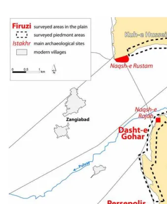
The region of Persepolis was divided into several working areas (Fig. 7). In the Royal Precinct and at Dasht-e Gohar, we have tried to better deter-mine the plan and the limits of these two groups of royal buildings. In Firuzi and Persepolis Northwest, our goal was to find the possible remains of the supposed city by surveying the sites published by Tilia and Sumner. To gather new information about the occupation of this region, we also decided to carefully study all the archaeological remains on the piedmont areas of the Kuh-e Rahmat and Kuh-e Hussein mountain ranges.
on new information gathered on a wider scale, mostly to the west of the Terrace, in order to provide a broad perspective on what we suppose may have been the ancient managed landscape in the vicinity of the “city” of Persepolis.
2.1. Field research in the Persepolis Northwest area
2.1.1. Context
The area to the northwest of the Terrace was the location of a group of tepes, labelled Persepolis West by Sumner. He described the site as a clus-ter of tepes sprawled over 25 ha (Fig. 2) and covered by a quite high density of Achaemenid/LPW sherds (Sumner 1986: 9). At the time of Sumner’s sur-veys, Persepolis West had already been largely destroyed by the present agriculture, preventing a better evaluation of the surface covered by the supposed remains of the common city.
The archaeological landscape described by Sumner has totally changed today. Beyond the western edge of the Terrace, the plain was first covered by installations built for the 1971 festivities, and then intensively culti-vated. Hence, there are no more traces of the large complex of the Perse-polis West cluster of mounds. When we began our work, at the time of our first surveys in 2005, the archaeological map of the Persepolis Northwest area showed only small and loosely distributed known archaeological points. Outside of the Royal Precinct, only some scattered architectural stone blocks were visible on surface. While they confirmed the presence of archaeological remains to the west of the Terrace, they could nevertheless not constitute the starting points of our surveys because they were mostly displaced. We therefore carried out a survey of the region, based on study of the old topographic documents and in order to determine the exact places where Sumner worked, since most of these remains have disap-peared today.
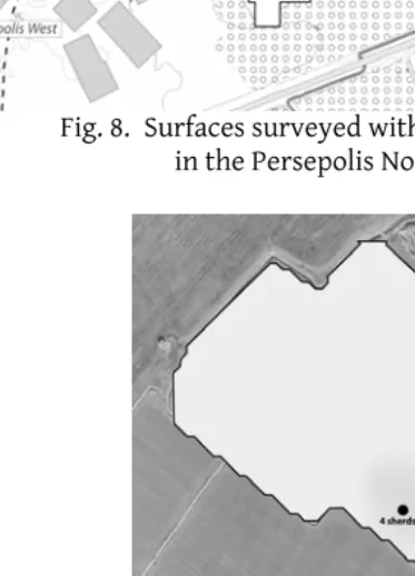
the sections of a group of deep modern-day trenches reveal a 2 metre-high stratigraphy showing a succession of archaeological layers. The small number of identified sherds collected in this stratigraphy seem to be re-lated to the Late Plain Ware shapes. This identification must be considered bearing in mind the small number of sherds. What is most encouraging about this find is that despite the levelling of most of the mounds, some archaeological deposits are still preserved, at least around small residual hills. Farther east, 500 m in the direction of the Terrace, north of the large parking lot located near the modern entrance of the site (Parking West on Fig. 8), field-walking surveys in the available fallow fields allowed us to measure sherd density (Fig. 9). Again, ceramic shapes were comparable to those found at Persepolis West and were mostly identified as LPW shapes. Furthermore, several architectural stone blocks have been found dotted over the surface between Persepolis West and the Royal Precinct; hence these observations suggest an extension of the limits of what Sumner la-belled Persepolis West to a wider surface. That is why we will refer to this zone as the Persepolis Northwest area.
Further support for this position can be found in the magnetic surveys conducted by B. Aminpur on behalf of the PPRF between 2004 and 2006 (places of these surveys are reported on Fig. 8, for a preliminary report concerning the results obtained cf. Aminpur 2006). The results showed many anomalies, probably related to an ancient occupation, suggesting a certain preservation of the archaeological remains. The occupation seems to extend over the entirety of the surveyed surfaces and specifically to-wards the east of Persepolis West. The fruitful magnetic maps obtained by the PPRF as well as the large spatial extent of the possible Persepolis Northwest occupational area led us to adopt a methodology essentially based on large-scale magnetic surveys.
We focused our magnetic surveys on two areas (Fig. 8): the first being to the west and corresponding to the exact place of the so-called Persepolis West; the second nearer to the Terrace, on fields where high sherd densi-ties were found and that had been partly covered by PPRF magnetic sur-veys.
2.1.2. Results of magnetic surveys
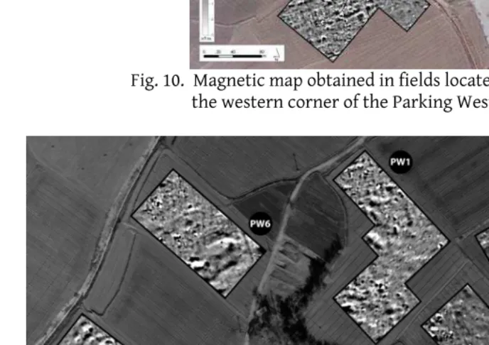
result is the presence of long rectilinear anomalies (Fig. 10).9 These make up a coherent rectangular grid covering the whole of the surveyed surface. The lines of the grid are oriented in a different direction than the present day fields and they run across different modern parcels. This causes us to think that they belong to an ancient management scheme. Within this grid, some higher magnetic sectors can be observed, particularly in the south-ern part of the field. It is very difficult to determine whether there was an organisational plan, or to observe individual buildings, within these sec-tors. However, it is highly possible they correspond to an ancient built zone. This hypothesis is confirmed by the comparison of the results of the magnetic survey with the sherd density map obtained on the same field (Fig. 9). In fact the sector of higher magnetic values exactly matches the area of maximum sherd density. The latter certainly results from the pres-ence of ancient buildings. However, the magnetic map does not provide an accurate plan of any buildings. This could be explained by the fact that the topsoil has been deeply ploughed and any remains might be considered partially to fully disturbed. It is important, in this respect, to underscore that the remains in the whole region surrounding the Terrace are not deeply buried. This is demonstrated by the presence of many stone blocks on the surface, as well as the shallowness of the structures excavated nearby, for example in the so-called “Frataraka temple” or, in the southern part of the Royal Precinct, in the Barzan-e Jonubi.10 Nonetheless in those higher magnetic areas, values could be explained by concentrations of magnetic materials in the topsoil layer resulting from ancient human ac-tivities. In addition, a resistivity survey, which measures differences of electric current flow in the subsoil, was carried out on the Parking West, located a hundred meters farther south. We briefly mention this survey because it revealed a shallow archaeological layer – probably partly made of resistant collapsed building materials – near the north corner of the
——————
9 All these long linear anomalies are plotted with black lines on the general sketch
interpretation map (see Fig. 12).
10 Herzfeld 1929: 32-33 described architectural stone blocks shown on the surface
parking lot. As it was the case for the magnetic survey, it is impossible to make out plans of constructions; however these results could at least con-firm the existence of a subsoil layer comprising anthropogenic materials.
In the so-called Persepolis West sector, we were able to carry out mag-netic surveys on six separate fields. Due to the greater subdivision of the cultivated lands at this location, the survey was divided into several smaller plots, close to one another (Fig. 8). The results obtained are quite comparable to those from further to the east (Fig. 11). However, the an-cient organisation scheme is more difficult to detect due to the greater perturbation of the subsoil layers linked to intense recent levelling works. These have particularly affected the three fields located to the east, which form terraces with a difference in height of almost 0.5 m between them. Thus, the disappearance of any anomalies linked to archaeological remains towards the east reconfirms the shallowness of buried structures at this location: terracing works on the first meter of soil appear to have removed all archaeological traces. Again, in the western fields of the Persepolis West sector, long linear anomalies associated with higher magnetic sectors ap-pear on the magnetic maps. The orientation of these long lines is parallel to those detected farther to the east. In this area, we should also note the recent discovery by the Iranian-Italian team of the remains of kilns (Callieri, this volume). Kilns produce high magnetic materials that could explain some of the values measured here. In which case, the high mag-netic sectors could also be linked to the remnants of artisanal production activities.
2.1.3. A broad organisational scheme
The total surface of the geophysical surveys, even including the fields sur-veyed by the PPRF, only represents a small part of the greater Persepolis Northwest area. Nevertheless, the results obtained at the different loca-tions make it possible to suggest what the organisational scheme may have looked like at the scale of the entire area (Fig. 12). The ancient occupation area characterized by Sumner as Persepolis West was limited to 25 ha. Based on our results, this in fact looks to have been only a part of a wider occupa-tion area extending farther to the east, up to the vicinity of the Terrace. Gathering together all the geophysical data, we can produce a sketch map of an ancient organisation pattern of the whole Persepolis Northwestern area.
the PPRF and the Iranian-French teams, lay out a large grid scheme and delineate ancient parcels. The cells of this grid are not regular. They have areas ranging from 0.5 ha up to several hectares. The nature of the long lines is debatable. It is interesting to observe that generally the east/west oriented lines are single while the north/south oriented are double. This could reflect the fact that the remains are of a different nature depending on their orientation. We suggest that all these rectilinear anomalies corspond to the remains of ditches. The results of the soundings opened re-cently on these lines by the Iranian-Italian team seem to confirm this hypothesis. The fact that the north/south oriented linear anomalies are double may correspond to two ditches with a possible pathway in between.
The nature of the occupation within these parcels cannot be deter-mined. But it does seem possible to distinguish two different types of sec-tor, with the type of occupation varying between them. For the sectors with high magnetic values, we imagine some built surfaces. These sectors are quite sparse, so the geophysics suggest that the built surfaces is discon-tinuous. For the sectors with lower magnetic values, the geophysical re-sults do not allow us to determine the nature of the occupation. The varia-tions of magnetic response from one area to another could be explained by a different type of occupation, or alternatively, at certain locations particu-larly disturbed by modern agriculture, a different state of preservation. On the large field located to the east of Persepolis Northwest area, next to the Parking West, the perfect match between the variation of sherd density and magnetic measurements tends to show that these differences could be linked to the ancient settlement pattern of the region. Within the regional settlement pattern, this area could well have shared one and the same or-ganisational scheme, a large grid delineated by ditches and comprising both built sectors and unbuilt spaces. The latter were nonetheless organ-ised and must have been used as gardens, orchards or would have housed light structures.
demonstrate that it was part of the same organisational scheme and maybe partly contemporary.
A final problem raised by these results concerns the limits between the Royal Precinct and the possibly more common occupation spread over the Persepolis Northwest area. On the several geophysical maps produced to the west of the Terrace, we have not found any traces of a large wall, such as the possible second rampart of Parsa suggested by Mousavi (Mousavi 1992). On this important question – the delineation between possible occu-pations of a different nature within the same city – we cannot offer conclu-sive remarks, and the question remains open.
2.2. Field researches around the village of Firuzi
2.2.1. Context
Altogether, the entire Firuzi occupation area defined by Sumner covered a broad surface of some 600 ha (Sumner 1986: 8-9 and 12-Table 1). The set-tlement pattern is characterized by a low density of isolated sites (Fig. 2) and the first question raised concerns what link might exist between the sites. Moreover, Sumner has suggested that the Firuzi area constitutes, with Persepolis West, a part of a same city. A second question of impor-tance would thus be how these two areas, Persepolis West (enlarged after our surveys to the wider Persepolis Northwest area) and Firuzi, can indeed be linked. This link could possibly be reflected by a common organisational scheme.
comparison, the sites in Bagh-e Firuzi are better preserved; thus we con-centrated our surveys in and around sites in this sector.
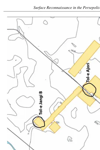
Like in the Persepolis Northwest area, we coupled surface surveys with a broad magnetic survey. We had two objectives: first, to provide informa-tion on the tepes themselves and to detect any building plan, since previ-ous excavations only provided partial maps of these remains. Second, we also studied off-site areas, beyond the known tepe limits, in order to detect possible new buildings or remains of ditches, canals or roads that would provide an image of any ancient landscape management. Particular atten-tion was paid on the eastern limit of Bagh-e Firuzi. The three sites that de-termine this limit were surveyed, as well as the fields between them. There, the magnetic survey corresponds to a 600 m long continuous strip located between the sites of Firuzi 5, Tol-e Ajori and Tol-e Jangi B11 and included the three mounds (Fig. 13). Altogether, the surveys carried out in Bagh-e Firuzi have covered about 6 ha.
2.2.2. Results of magnetic surveys
Along the strip surveyed, the results obtained in the area between the tepes are quite poor. With the magnetic method, we were not able to dis-cover traces of buildings or installations. Also, the surface showed an al-most complete lack of sherds. In comparison with the Persepolis Northwest area, the magnetic map does not show any series of long linear anomalies, nor any sectors of higher magnetic values. Nevertheless, some information was collected about the organisational plan of the remains on the tepes and their periphery.
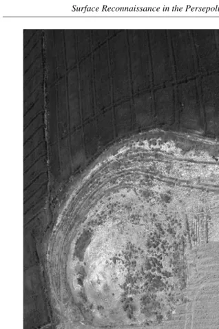
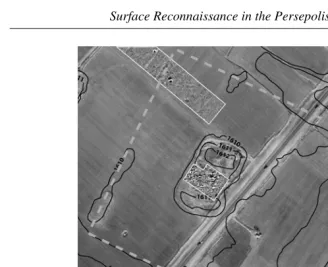
The best results were obtained on and in the immediate vicinity of Tol-e Ajori (Fig. 14). On its surface, this site presents a high density of baked brick fragments. These concentrations are particularly dense in a large modern ditch, which cuts across the northern part of the tepe. For Tilia (1978: 84-85) and Sumner (1986: 9), Tol-e Ajori could have been a brick kiln.
——————
11 Whereas we keep the name of the sites around Firuzi given by W. Sumner, we
The results of the magnetic survey, however, suggest that this hypothesis must be rejected. The remains of a kiln would induce very high magnetic anomalies of a particular, identifiable shape; these were absent. Because the baked bricks produce high magnetic anomalies, the magnetic method is very effective in detecting architectural remains made of this material. On the magnetic map we obtained, one can observe the plan of a 40 m square building. Probably because of the presence of a high density of col-lapsed baked bricks within the limits of this building, it is difficult to fur-ther detail an interior plan. A square anomaly in the centre could be the remains of some structures. We suppose that this building consisted of only a single hall. In addition Tilia published a variety of glazed bricks on this site (Tilia 1978: Pl. LII). In our reconnaissance, we were only able to find one such sample. Given its size and the fact that it was built with baked brick, a material only attested within the Royal Precinct, as well as the probable presence of glazed brick decorative panels, Tol-e Ajori would appear to have been a luxurious building, of royal or aristocratic status. The site is under current excavation by the Iran-Italy archaeological team.
Magnetic prospection results also offer some information about the ex-tent of Firuzi 5, to the southeast of Tol-e Ajori. For Sumner, Firuzi 5 con-sisted of a rectangular tepe of 3.5 ha enclosed by a large enclosure of 500 m long and 450 m wide (Sumner 1986: 8). Today only the southwestern half of the central tepe has been preserved. Recent diggings brought to light a se-ries of stone platforms along the eastern present-day tepe limits. The na-ture of these constructions is enigmatic, and the results of the magnetic survey on the tepe do not offer any clear plan of the building to which these platforms could belong. The most striking results were obtained out-side the tepe and concern the existence of a peripheral enclosure of which there is no trace in the present day landscape. There is a mound, located 200 m west of the rectangular central tepe, that could constitute the sole remains of this enclosure.12 Further to the northeast, in the axis of this mound, we can observe a long linear anomaly, 8 m wide on the magnetic map (Fig. 15). It probably relates to the continuation of a possible enclosure farther towards the northwest. Thus, at Firuzi 5, the magnetic survey al-lows us to confirm the existence of a large enclosure around the central tepe. A wide depression around the rectangular mound appears to have been part of the former topography of the site, judging by the map from
——————
the 1960s used by Sumner (drawn on Fig. 15). So we suppose that the possi-ble enclosure was associated with a ditch. Whatever the nature of the pe-ripheral constructions and as Sumner correctly presumed, it is quite obvi-ous that Firuzi 5 is not limited merely to its central rectangular mound but spreads over 25 ha. With this in mind, the space between Firuzi 5 and Tol-e Ajori is largely reduced and the gap between both sites could be partly filled. This raises two questions. First, since between the rectangular mound and the possible enclosure the magnetic map does not show any built installations, the function and the precise plan of Firuzi 5 remain en-igmatic. The second question concerns the date of Firuzi 5. The attested ceramic is scant and undatable. The architectural remains could be related to the Achaemenid era, but all the same the blocks – quite roughly carved – could have been reused in later periods. We can only underscore the fact that the constructions in Firuzi 5 are parallel in their orientation with the building of Tol-e Ajori and could be related to the same organisation scheme.
2.2.3. Organisation and status of the Firuzi area
In conclusion, Bagh-e Firuzi consists of a royal or aristocratic occupation, while Firuzi South and Persepolis Northwest might well correspond to more common settlements. For the moment, it is impossible to clearly de-termine a link between all these sectors. To what extent these sectors con-stitute a unique area, corresponding to a unique city is a difficult issue. For the time being, we can only conclude that the orientation of the known buildings in the Bagh-e Firuzi sector is different from the orientation mapped at Persepolis Northwest. Similarly, the high quality of architecture in Bagh-e Firuzi suggests a settlement area with a status or function ent from Persepolis Northwest area. Each probably corresponds to a differ-ent landscape managemdiffer-ent project and organisation scheme, perhaps not designed at the same time.
considered as a non-aristocratic occupation sector, that must be distin-guished from the aristocratic Bagh-e Firuzi.
2.3. Surface surveys in the piedmont areas
Along the Kuh-e Rahmat, as well as near Naqsh-e Rustam, surveys of pied-mont areas allow us to identify intense quarrying activity (Fig. 21). This has been partly studied by W. Kleiss (Kleiss 1976, 1981, 1994) who recorded dif-ferent quarry sites distributed along both mountain ranges. Our systematic study of these piedmonts showed much broader stone quarrying in the Per-sepolis settled zone.
We recorded ten spots showing traces of quarrying in the Kuh-e Rahmat mountain range. In this area, workers used natural faults in the limestone outcrops to produce blocks. Thus, we do not find elaborate quarrying faces on these piedmonts. A huge volume of stone could have been extracted without leaving a trace. The quarrying activities can only be identified if unfinished blocks are left abandoned. We can therefore observe a quite continuous distribution of these unfinished blocks, or group of blocks, be-tween the Terrace and Estakhr. This could attest the widespread use of the rocky outcrops all along the Kuh-e Rahmat piedmonts.
East of Naqsh-e Rustam, we discovered even more intensive quarrying activity. In this zone the techniques produced more of visible quarrying faces. From Naqsh-e Rustam to 2.5 km to the east, we recorded three main quarrying areas along the piedmont. Further to the east the cliffs curve inward forming a large “cirque”. The slopes have continuous traces of quarrying from the cliffs 300 m above the plain to the base of the pied-mont. Traces of cuts in the rock can be found scattered over a length of 1 km. Thus, a surface of more than 300 ha seems to have been extensively quarried.
The date of these quarries is unclear. Rock cut techniques did not evolve much between the Achaemenid era and more recent periods.13 But given the scale of the quarry work, as well as the size of some individual blocks (as an example see Fig. 16), the period of most intense activity can be tentatively dated back to the Achaemenid. After this period, the use of stone elements for buildings decreased considerably. We also wish to
——————
13 Pers. com. of J.-C. Bessac (CNRS, UMR Lattes) specialist of the ancient stone
underscore the proximity of these quarries to the several Achaemenid con-struction sites. Although the surveys along the piedmonts did not discover inhabited areas, the intense quarrying activity would have required that a large number of workers live next to the mountain, that is to say within the Persepolis settled zone.
Also, our surveys along the Kuh-e Rahmat allow us to study the exact path and slope of the canal running along the base of the piedmont. This canal existence was known (Kleiss 1976), but it has never been precisely studied. Our topographical work demonstrates, by calculating the slope of the canal, that it was not built in order to feed the buildings on the Terrace. The elevation of the Terrace (average 1630 m) is too high in comparison to the elevation of the nearest canal section (1611 m, 800 m to the north of the Terrace). It was probably built in order to provide water to the fields extending all along the mountain piedmont as well as those located at the foot of the Terrace. This canal is another indication of the investment car-ried out during the Achaemenid era in order to develop the vicinity of Per-sepolis over a surface larger than the Royal Precinct alone. The question of the source of the canal, its integration into the wider Persepolis Plain net-work, as well as the techniques for its construction will be further dis-cussed in the part 3.
3. T
HEW
IDERP
ERSEPOLISP
LAIN:
T
RACES OFH
YDROLOGICALI
NVESTMENTIn a semi-arid setting such as that of the Persepolis plain, the traces of hydrological investment provide a useful and interesting dataset for such purposes. Much like other parts of the Zagros mountains, central Fars pre-sents a typical Mediterranean precipitation pattern which precipitation and river discharge concentrated in the winter period and subject to high inter-annual variability. Only recently, new geomorphological research and climate proxy data for the area has provided further details on the dynamic nature of the Persepolis plain and on the first millennium BC physical setting. These tentatively indicate that in the Achaemenid period, climatic conditions must have been largely similar – if not more arid – to those today (Djamali & al. 2009, Kehl & al. 2009, Rigot 2010).
The control of water within such climatological and hydrological cir-cumstances was unmistakably crucial. For one, the semi-arid climate and deep incised river14 implied the establishment of large canal systems with canal heads several kilometres upstream of the actual area of agricultural benefit. Secondly, just as in recent history, one was probably also con-fronted with erratic floods, typical for more arid climates, to which hydro-logical responses and large embankments were indeed installed. Work at both Persepolis and Pasargadae has shown such preventive measures were equally important as the measures for water procurement, and we will therefore focus on both types of water related features.
Given the imposing landscape changes in the last 50 years and the dis-turbed or even ‘destroyed’ character of the landscape, the remains of pos-sible canal heads, canals, embankments are not easily identified. Where possible, mapping, augering and sampling were carried out, but overall, the analysis and mapping of the canal traces and networks relied heavily on the use of historic imagery and the 1960s detailed maps (at a scale of 1/5000). On the CORONA espionage satellite imagery, now a widely used remote sensing source in Near Eastern archaeology (De Schacht & al. 2008), the possible traces of the canal can be seen as a set of dark soil- or crop-marks, or possibly still as landcrop-marks, visible on surface. Dating to spring of 1970, the CORONA imagery allows not only to have a mere look at the pre-modern landscape of the 1960s. But in combination with the historic maps, the possible ancient canals can be traced along with natural drainage in the plain and the traditional patterns of irrigation use and water
procure-——————
14 For a historic account of the river’s incision, see particularly Quintus Curtius
ment of the 1960s. Furthermore, mapping these pre-modern and older irri-gation networks allows to identify specific networks or delimit particular zones of irrigation. In general, such zones provide a clear indication as to what is the closest, and most logic source of perennial flow. On the basis of this mapping, the different ancient canal traces can then be reviewed in a broader context.
Overall, the mapping largely confirms those sets of abandoned canal systems that were first presented in a Sumner’s seminal synthesis (1986). Within these, we observe that the possible Achaemenid hydrological fea-tures reveal to be constructed on different scales. Here, three cases studies are presented (Fig. 17). While a first system, that of the Sang-e Dokhtar ap-pears to be developed at the scale of the plain itself, the second example (Kuh-e Rahmat canal) has a more limited geographical and hydrological scope. Finally, in a third case study (Band-e Bas 2), a more enigmatic fea-ture is presented, for which the exact functioning scale and overall func-tion is more difficult to establish. This last example show how systems of water protection are also to be included in the general overview of Achaemenid water practises in the Persepolis plain.
3.1. Sang-e Dokhtar canal, hydraulic investment at a regional scale
As one of the few but major, possible Achaemenid water provision system of the Achaemenid period, the canal of Sang-e Dokhtar is some 50 km long and is situated on the left bank of the Rud-e Kor (Fig. 17).
3.1.1. Past archaeological data and present day conservation state
Though other canal traces of presumed Achaemenid date were also intro-duced by Sumner, the canal system of Sang-e Dokhtar reveals the only sys-tem that has been studied to some depth so far. Since the 1960s, its head-water stretches are largely straightforward, thanks to the presence of two monumental Achaemenid buildings along its path: the canalhead site of Sang-e Dokhtar (from which the canal adopted its name) and the site of Bard-e Burideh II. Further along the possible path of the canal, other traces or sites had also been briefly surveyed in the past (Kleiss 1981).
and the following year, Tilia took the responsibility to disassemble and re-construct the building on a new location, downstream of the new dam. In disassembling the monument, they observed that the building blocks showed narrow toothed chisel marks on the anathyrosis-bordered surfaces and are most probably Achaemenid in date (Tilia 1978: 89-90, 1997).
While small wall remains of the Sang-e Dokhtar canal are visible down-stream of the canal head, the continued path of the canal has been studied from a more remote distance, first by Nicol, with aerial photographs and a helicopter survey (Nicol 1970: 264) and secondly, by Sumner who also in-terpreted aerial photographs of the plain. Nicol could follow the canal up to a point southeast of Kuh-e Shahrak, and Sumner further traced the ca-nal, over a long distance, down into the area of Kuh-e Qaleh (Sumner 1986: 13). In the upper course of the canal, Sumner was also the first to propose a firm link between the canal and the large ashlar-built platform of Bard-e Burideh II, located on the Rud-e Bidun (Bergner 1937: Tafel I & II, Tilia 1978: 90).
Today, the canal has nearly completely been erased from the plain’s surface and for a large part, its course was chosen in the 1970s to implant one of the large artery canal of the new concrete built irrigation network. In other areas, the canal-depression is completely infilled and much of its upcasts were levelled down. In the present condition, the study of this canal is thus highly difficult and only at minor instances can the canal be found in the field. As an example, a local and small scaled survey in the Tang-e Dorudzan, just downstream of the canal head, provide the traces of two parallel boulder built walls, possible remains of the canal banks. The remains are probably to be identified as those remains of canal wall, earlier reported by Nicol. But the survey also showed that much of the canal’s sur-roundings, corresponding to the original upper terrace on which it was situated has been largely eroded by the river or artificially levelled down.
3.1.2. The canal course studied through the 1960s maps and CORONA images
Sang-e Dokhtar canal. Though partly supplanted by a still active irrigation channel with large flanking upcast deposits, the original canal must have continued beyond the aqueduct and further to the southern point of the Kuh-e Shahrak, from where it can be spotted again as a clear linear darkish cropmark on CORONA imagery, running in eastern direction. These marks probably correspond to the traces of what Nicol and Sumner have seen on aerial documents.
In the northeast of the Persepolis plain, near the confluence of the Rud-e Main and thRud-e Rud-Rud-e Kur, thRud-e situation of thRud-e canal is somRud-ewhat difficult to reconstruct on the basis of the remote sensing data (Fig. 18). Parts of the trace turn slightly north, but how this trace continued is rather difficult to reconstruct. Further east, the secondary plain of the Rud-e Main slopes down from east to west, and the canal of Sang-e Dokhtar could only have had limited use in this well-watered area. As Sumner also noted, a second cropmark can be observed on both sides of the Rud-e Main. Given its ap-pearance and setting, this might well have been a canal and aqueduct, pro-viding a connection to farther canal traces along the Kuh-e Hussein. The historic maps indeed indicate that a narrow ramp was present at this loca-tion. However, the question whether this secondary trace was indeed a part or a phase of the Sang-e Dokhtar canal cannot be resolved, since a field reconnaissance in 2008 has shown that these remains of the canal and the possible aqueduct have nearly completely been erased or supplanted by recent concrete canals. For these reasons, they are unavailable for fur-ther study, targeted augering or any sampling for dating analysis (f.i. for Optical Stimulated Luminescence (OSL)). Nonetheless, a useful remark can be presented here. The CORONA satellite images show that at a certain stage, the possible aqueduct was apparently cut by the river. The absence of any aqueduct traces on the lower river terrace, in the field or on the im-ages, might well indicate that this destruction must have occurred some-where in the second half of the first millennium AD, at a time when this lower, second river terrace was established (Rigot 2010: 66). This geomor-phological reconstruction thus provides a partial terminus ante quem, how-ever broad, for these zones of the canal system. It would indeed show the construction and period of use of the canal to be at least Sasanian or older.
the most ideal location for the main concrete canal irrigating this part of the plain, thus supplanting the original ancient canal. The canal circles the Kuh-e Estakhr and can be followed up the site of Tol-e Kamin. In Sumner’s view, the canal mainly served to fill a large but shallow reservoir to the east of Kuh-e Qaleh. And indeed, a 2.7 km long but only 2 m high dike (named Band-e Bas 1) has been recorded, spanning the valley floor. How-ever, a new interpretation can be proposed for this ensemble. For one, the remote sensing imagery clearly shows the canal to circle this feature and no clear relation between the two is evident. Secondly, beyond the dike and Tol-e Kamin, we furthermore noted the continued presence of ancient canal remains, well in alignment with the Sang-e Dokhtar canal. Last but not least, microtopographic mapping, augering and soil sampling at the site of Band-e Bas 1 did not provide any substantial evidence for long peri-ods of impoundment or sediment deposition on the upstream side of the dike. Additionally, in respect of similar low dikes, and comparable con-struction techniques at the Achaemenid-dated weirs in the Pasargadae area (see study on Band-e Bas 2 below), the function of this embankment might well be that of a protective dike, blocking any flow from the well saturated spring area to the northeast or from possible floods from the large alluvial fan to the east of the dam. Its therefore has no evident rela-tion with the canal, even though the site would merit further field re-search.
In all likelihood, the Sang-e Dokhtar canal most probably continued fur-ther south. Though only partly preserved, the abandoned canal system can indeed be followed downstream, even up to the Rud-e Polvar, on the oppo-site bank of the Firuzi area. In comparison to the traditional irrigation sys-tem of the 1960s (that originates near Naqsh-e Rustam and flows in west-ern direction), the infilled depressions and dark cropmarks of the canal trace, cut across this main irrigation scheme in perpendicular direction. However, beyond the Rud-e Pulvar river, no traces are visible and our ex-ploration of this at canal is to be stopped.
3.1.3. Features and function of the canal
is clearly Achaemenid in date, it is presently difficult to determine if there is any chronological phasing in the construction or possibly expansion of the canal. For the time being, we were only able to provide new elements on a secure terminus ante quem for parts of the system. Given that the canal remains would largely have been eroded at the time of the establishment of the second, lower terrace level of the Rud-e Main, it is clear that much of this system did not continue to function beyond somewhere in the Sa-sanian period of the first millennium AD. Together with the ashlar canal remains of Sang-e Dokhtar and Bard-e Burideh, this geomorphological event provides the sole clear chronological marker, however broad.
Similarly, it is hard to determine for which areas of the plain this canal served as a main feeder canal since previous surveys or the remote sensing data did not reveal any secondary, branching canals. Nor does the canal link particular areas of known important Achaemenid sites, nor of any large arable surfaces apart from those discrete areas southwest of Kuh-e Shahrak and the area of Tol-e Kamin, to the south of the Kuh-e Qaleh mesa. Nonetheless, the actual lay-out of the canal systems shows how it poten-tially functioned for a very large part of the left river bank of the Rud-e Kur. Through its mapped course, the canal could provide perennial flow from the high volume discharge of the Rud-e Kur. It did so for several ar-eas, which themselves are naturally watered by rivers of the Rud-e Bidun, Rud-e Main or the Rud-e Polvar. These are all tributary rivers with smaller catchments and more irregular hydrological regimes. Possibly as a deliber-ate design consideration, the canal must have assured the most reliable source of water. For these reasons, the canal definitely had one (on the Rud-e Bidun), presumably two (on the Rud-e Main) and hypothetical three aqueducts (on the Rud-e Pulvar). In as such, it presents a particular engi-neering achievement, even to the scale of the recent 1960s – 70s canal sys-tems, implanted over the full width and scale of the plain (Justin and Courtney & Irrigation Corporation of Iran 1965). Secondly, it can also be compared to the known systems in the Neo-Assyrian upland, also crossing several hydrological zones and interfluve areas (Ur 2005).
3.2. Kuh-e Rahmat canal, hydraulic investment at the scale of the Persepolis settled zone
The remains of a canal lining the northern and northwestern piedmont of the Kuh-e Rahmat range are particularly well preserved in between the site of Estakhr and the Royal Terrace. Though differing on several points, the piedmont canal is somewhat similar to what the Iranian-French project mapped in the Tang-e Bulaghi (Atai & Boucharlat 2009). The canal is com-posed out of both rock cut and constructed parts. Several of the remains along the Kuh-e Rahmat were reported by earlier surveys or visits, and today a more general description of this canal can be presented, based on both remote sensing and topographic mapping.
3.2.1. Past archaeological data
3.2.2. Source and destination of the canal studied by topographic surveys and CORONA images
Of all these elements, the topographic mapping in the field as well as the interpretation of the historic CORONA satellite imagery provides fruitful clues to assess the canal as a whole. Along the Kuh-e Rahmat, the canal is composed out of both rock cut and constructed parts, of which only the foundations are preserved. From Estakhr onwards, the canal has an overall slope of 2‰ and its width was about 50 cm or more. Along its path, only one or two secondary branches were found in the Estakhr area, though one is to observe that for large parts of piedmont, the canal has disappeared completely and it is therefore difficult to assess the possible use along its path.
With the trace of the canal known, we will further concentrate on the actual source of the canal. No traces are however present in the field and no former springs could be found both on the topographic map or in a sur-vey of the area. The geological map also shows that the area, proposed by Kleiss as the area of a karstic source, is highly unsuitable and the strata, dipped to the northeast, do not favour drainage to the contact zone of the plain and the mountain-range. Secondly, a possible canal head or dam in the river channel of the Rud-e Polvar is also to be discarded as a hypothe-sis. No such traces are visible. What’s more is that in the first millennium BC, the Polvar would already have been well incised into the alluvial plain, as evidenced by the geomorphological studies (Rigot 2010, Kehl & al. 2009). Any river-located capture in the Estakhr area would have necessitated a water lifting device or a large dam, partly flooding the actual plain since the piedmont canal is located a higher elevation than the plain adjacent to the river.
Seidan area, which is an area with known architectural Achaemenid re-mains (Whitcomb 1969). Through a low arced detour south of the mound of Tol-e Qaleh, also with Achaemenid period finds (Sumner 1972: 285), the canal would have connected to the Kuh-e Rahmat canal’s most eastern constructed remains, near Estakhr. Along this trace, the reconstructed ca-nal had a slope of 1.5‰ (on surface level).
Discharge figures as provided by Moradi-Jalal & al. (2010: 94) for the springs at Seidan are insightful. In their present day state, the sources pro-vide a similar overall discharge as the Rud-e Pulvar, but given their charac-ter, they surely present a more reliable and perennial source (of 500 L/s) than the erratic discharge and occasional floods of the Rud-e Polvar (for 20th century values for the Rud-e Pulvar, see Kortum 1976: 50-51).
3.2.3. Features and function of the canal
In conclusion, we can safely propose the Seidan source as the start of the Kuh-e Rahmat canal. Overall, the canal would have been up to 20 km long, with a steady slope and with several Achaemenid sites (Seidan, Tol-e Qaleh, Takht-e Rustam…) and off-sites traces along its path. Much like the Sang-e Dokhtar canal, the source of the canal is of perennial nature and probably quite deliberately, a karstic source was chosen over the Rud-e Polvar as a main source for irrigation water.
Through its course, the canal links several smaller landscape units and canal construction techniques. While probably a ditch in the Dasht-e Olia near Seidan, the canal must have reached the level of the piedmont foot near Estakhr, from where it slightly rose above the plain’s level and thus could be used for irrigation through branching secondary canals.