Journal of Environmental Engineering & Sustainable Technology JEEST
Vol. 03 No. 02, November 2016, Pages 104-111 http://jeest.ub.ac.id
P-ISSN: 2356-3109 E-ISSN: 2356-3117 104
OCEAN CURRENTS ENERGY FOR ELECTRICITY GENERATION AND ITS
POTENTIAL IN EAST JAVA WATER, INDONESIA
1Nurin Hidayati, 2Mohammad Mahmudi, 1Dhira Khurniawan Saputra, 2Muhammad Musa, 3Hery Setiawan Purnawali
1 Marine Science Department, Brawijaya University, Malang Indonesia 2Aquatic Resources Management Department, Brawijaya University Malang Indonesia 3Geomatics Engineering Department, Faculty of Civil Engineering and Planning, Sepuluh Nopember
Institute of Technology, Indonesia 1E-mail: nurin_hiday@ub.ac.id
ABSTRACT
Electrical energy is one of the vital needs of the coastal communities, especially in coastal areas that are not affordable electricity network. To meet these needs energy diversification efforts are undertaken, such as the utilization of the energy potential of ocean currents. The aim of this study was to determine the seabed morphology and properties of hydro-oceanography as a reference the exact location in the utilization of the energy of ocean currents. Location of research in the territorial waters of East Java. Research methods such as measurement of currents, tidal observation, observation of meteorological parameters and conditions of the seabed morphology and the coastal area of research. The study was conducted to estimate the potential energy of ocean currents are spatially and temporally by utilizing a hydrodynamic model simulation results and the results of current data measurement in the field, and convert them into power unit. Which will ultimately produced maps of potential energy from ocean currents of East Java waters territory. In comparison, there are several advantages of ocean current energy utilization compared to other energy generation, such as the production of electricity generated by ocean currents each year tend to be stable and more environmentally friendly because without using fuel. Potential sites for power plants in East Java waters of the ocean currents are respectively Madura Strait Region, Southern Water of East Java, and Bali Strait water. Keywords: Ocean Currents, Energy, East Java
1. INTRODUCTION
Indonesia is a maritime country. According Mulyanef et al. (2006), its because the most of Indonesian territory is water. Republic of Indonesia consists of 17.508 islands, has a land area of 1,9 million km2 and a coastline of 80.791 km, as well as marine coverage area of 3.1 million km2 (Astirin, 2000). With its long coastline, Indonesian Water should be utilized as much as possible their potential to improve the life of community life from a variety of sectors such as from economic sectors that can utilize the results of marine and fisheries resources, the tourism sector which utilizes the beauty of exotic beaches and under the sea, to the energy sector that the energy of ocean currents and waves potential for power plants. Lots of sea energy source that can be utilized optimally, i.e including Ocean Thermal Energy Conversion (OTEC), wave, tidal and ocean current. Erwandi (2012) stated that renewable energy sources from the ocean can be classified as OTEC, waves, and ocean currents and tidal.
Journal of Environmental Engineering & Sustainable Technology (JEEST) Vol. 03 No. 02, November 2016, Pages 104-111
105 P-ISSN: 2356-3109 E-ISSN: 2356-3117
and oil reserves will be depleted 12 years. The researchers have already
Started actively looking for renewable energy with related research in order to get the solution of the issues on the limited energy. Ocean currents is the energy potential as a renewable energy. With the power generated, ocean currents can generate electrical energy. However, the utilization of ocean currents to produce electricity it is still not optimal developed and need to study in more depth.
Based on the territorial water profile, East Java is one of the provinces that has great potential for the utilization of ocean currents power plants. The territorial waters of the southern part of East Java which relate directly to the Indian Ocean, has the potential for tremendous ocean currents for power plants. While the territorial waters of northern East Java although it has a tendency sea currents are not too large, but in some parts of the waters potentially ocean current energy. But until now there has not been much researches on analysis of the potential energy of ocean currents, especially in the waters around East Java. So it is necessary to study in more detail on identification of potential energy from ocean currents; and analysis of the potential location of East Java waters for ocean currents power plants. Energy from ocean currents can be used to supply power to the regions which are not get electricity supply, especially for coastal communities in East Java. The aims of this study are to analyze the pattern of ocean currents in the waters around East Java, mapping the ocean currents energy potential, and to analyze the potential location of the territorial waters of East Java as the location of sea power plants.
2. METHODS
The method used in this research is descriptive analytic, which to analysis of the ocean currents characteristics and to mapping potential energy location of ocean currents of East Java Water. These activities are arranged matrix and map potential that describes the condition and the pattern of ocean currents, and created a map of the potential energy of ocean currents. In this study, it will produce an image pattern of movement of currents in the waters of East Java in order to describe the incidence of direction and movement patterns
of currents in the region. The analytical measurement data. Ocean currents data input to the software Surfer is the downloaded from open access data in podaac-ftp.jpl.nasa.gov website. Analyzed ccean currents data is ranging data from the period 2004 to 2015. The ocean currents map from data processing results are then verified using the ocean currents data of direct measurements in the field.
2.1. Location and Time Research
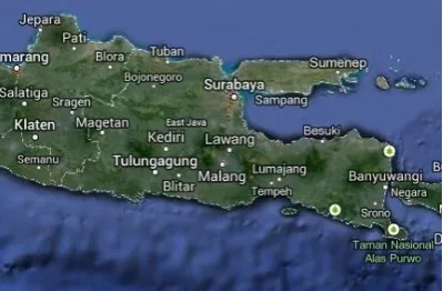
This research was conducted in the waters around the East Java. Current measurements in the field carried out in four (4) sampling area, which is in the waters Brondong Lamongan, Madura Camplong Water, Water Pasuruan, and the Strait of Bali (see Figure 1). While the time of the study carried out starting from May 2015 until October 2015.
Figure 1. East Java Waters with sampling location (Google Earth, 2015)
2.2 Collecting Data Methods
Journal of Environmental Engineering & Sustainable Technology JEEST
Vol. 03 No. 02, November 2016, Pages 104-111 http://jeest.ub.ac.id
downloaded by a period of years from 2004 to 2015. The downloaded data of ocean currents from the website OSCAR is a surface current vector data. This vector data will be processed so that it will be the speed of flow through the application of Ms. Excel and the data is grouped into wet season (December to February), transition 1 (March to May), dry season (June to August) and transition 2 (September-November) of each year. The velocity vector data will be input data at Surfer software processing. While the primary data in the form of ocean flow data obtained from direct measurements in the field.
2.3 Procedure
Procedure in this research are devided into several processes. A series process of this research can be explained as follows:
1. Determine of Sampling Location
At this stage, reference studies to determine the study area in the study. The choice of location is based on the dynamics of hydro-oceanography conditions, abundance of biological resources and the role of the location itself to human activities.
2. Data Collecting
At this stage of collecting the data necessary to study. This data collection is done by downloading site NOAA data server hydro-oceanographic data related to vector data flows and also with the help of software for bathymetric GEBCO data. The data collected are currents and bathymetry vector data in the study area 3. Processing of Vector Data Flow with MS.
Excel current vector data U and V as well as the currents velocity to be input data at Surfer. In this process also made the process of grouping the data stream is divided by division of season.
5. Satellite Data Processing Flow using Surfer. At this stage NOAA satellite data processing flow that has been processed using the application Ms. Excel to generate patterns of direction and speed of currents in the territorial waters of East Java. The pattern that will be generated is the pattern of the direction and speed of currents in every season of the year 2004-2015. 6. Verify OSCAR flow data with field
measurement data 7. Analysis of Data
In this step is the process of analysis. The analyzed data is the data from the current patterns of satellite data that has been processed using Surfer.
8. Analysis of the potential energy of ocean currents and identification of the best location for sea power plant
3. RESULTS AND DISCUSSION
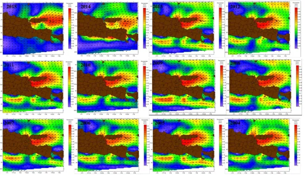
3.1 Sea Currents Pattern for Years 2004-2015
Current movement patterns in this section are performed data processing on average each year from 2004 to 2015. From the results of the annual average value is then created a map of the pattern of movement of the current year. Map of the annual flow of the year 2004 - 2015 is presented in Figure 2.
Journal of Environmental Engineering & Sustainable Technology (JEEST) Vol. 03 No. 02, November 2016, Pages 104-111
107 P-ISSN: 2356-3109 E-ISSN: 2356-3117
Figure 2. The pattern of ocean currents in East Java waters per year from 2004 to 2015
2015 2014 2013 2012
2011 2010 2009 2008
Journal of Environmental Engineering & Sustainable Technology JEEST
Vol. 03 No. 01, July 2016, Pages xx-xx http://jeest.ub.ac.id
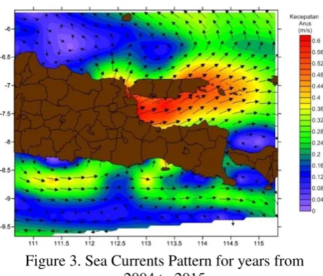
3.2 The Average of Sea Currents Patttern for Year 2004-2015
From the data speed of the average current East Java waters for 12 years (Figure 3), the result that local high-speed currents dominate the territorial waters of the Strait of Madura, East Java and South Water Strait of Bali.
Figure 3. Sea Currents Pattern for years from 2004 to 2015
To verify the data processing flow using satellite CIRA map data input (OSCAR), a comparison with the data of direct measurements in the field of observation.
3.3 Ocean Currents Pattern from Field
Observation
This research should be conducted to verify the data direct observation and measurement of the flow of data in the field. Current measurement conducted in 4 (four) sampling location inn East Java Water (Figure 1). Flow measurement locations in the field carried out at the following stations:
i) Station 1: Bodies Brondong Lamongan, these waters represent the data Brondong Lamongan East Java's northern waters. ii) Station 2: Bodies Camplong Madura,
these waters represent the data Camplong Madura Madura Strait northern part. iii) Station 3: Water Pasuruan
Pasuruan waters in this data represents the southern part of the Madura Strait waters. iv) Station 4: Strait Bali
The waters around Bali Strait represents the data Strait of Bali.
The ocean currents data from the field measurements are as shown in Table 1 – 4.
Table 1. Ocean Currents data of Brondong Water Lamongan
Table 2. Ocean Currents data of Camplong Water Madura
Journal of Environmental Engineering & Sustainable Technology JEEST
Vol. 03 No. 01, July 2016, Pages xx-xx http://jeest.ub.ac.id
109 P-ISSN: 2356-3109 E-ISSN: 2356-3117
Table 4. Ocean Currents data of Banyuwangi Water (Bali Straits)
X Y Average of
Speed current, V
(m/s)
Direction of Ocean currents (degrees)
114.40260 -8.48237 0.71 130
114.40247 -8.47772 0.68 115
114.40138 -8.47377 0.55 80
114.40185 -8.47112 0.50 122
114.40237 -8.46603 0.49 135
114.40093 -8.46077 0.61 110
114.39858 -8.45628 0.56 135
114.39652 -8.45340 0.64 130
114.39242 -8.44915 0.63 120
114.38518 -8.44623 0.78 85
114.37997 -8.43498 0.47 98
114.37507 -8.44805 0.54 100
114.37240 -8.44628 0.73 110
114.37362 -8.45010 0.62 100
114.37140 -8.45090 0.57 40
114.37383 -8.45390 0.62 120
114.37567 -8.45423 0.48 110
114.37685 -8.45632 0.36 145
114.37803 -8.45910 0.63 125
114.35470 -8.43932 0.54 120
3.4 Energy Convertion from Sea Power Flow
The working principle of Power Flow Sea is to utilize the movement of the turbine generated by power current to drive the generator, so that the generator can produce electricity and electrical energy is mostly channeled directly to the user (user), and partly stored in the power bank (accu ). The electrical output power of sea power flow can be obtained through the following equation:
𝐏 = 𝟎, 𝟓 × 𝛒 × 𝐀 × 𝐕
𝟑In this study the energy conversion from current speed unit is calculated into units of energy (watts). Conversion is done on the generator with the type of Darrieus turbine and Gorlov type.
3.5. Conversion of Electrical Energy Using Darrieus turbine type
Turbine serves to convert water energy (potential, pressure, and kinetic) into mechanical energy in the form of shaft rotation. Forwarded to the turbine shaft rotation axis of the electric generator via a transmission system to generate energy listrik.Tipe Darrieus turbine is widely used for wind turbines (VAWT-Vertically Axis Wind Turbine) the wind turbine by using a large blade that extends vertically downwards with a curved shape (Figure 4).
Figure 4. Darrieus Turbine Type
Sea Power Flow pda's research, turbine used is to use the principle of vertical axis Darrieus turbine. This type is also widely used for wind turbines with the same type of axis (VAWT - Vertcally-Axis Wind Turbine), namely wind turbines by using a large blade that extends vertically downwards with a curved shape
Table 5. Number for Darrieus Turbine Type
(A)
3
m
(ρ)
1030 kg/m
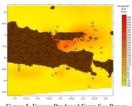
3Flow data obtained from previously calculated in the range of power output to be received sea power flow. Potential power generated as shown in Figure 5.
Journal of Environmental Engineering & Sustainable Technology (JEEST) Vol. 03 No. 01, July 2017, Pages xx-xx
3.6. Conversion of Electrical Energy Using Gorlov turbine type
Gorlov turbine is one type of turbine that uses the vertical axis. Gorlov turbine is a turbine modified and developed by AM Gorlov using vertical axis. Using a vertical axis turbine is believed to better harness ocean currents than turbines with horizontal axis. Many uses and advantages possessed by the turbine vertical wheelbase, among which the simple design and simple and low cost.
The Gorlov turbine into the classification of vertical axis turbine with a helical blade. Helical blade is a fan shape or strands of the helix-shaped turbine (Figure 6).
After knowing the formula for the calculation of power conversion, then the value of the instrument is inserted into the formula Gorlov turbine along with the current velocity obtained. The value of the tool Gorlov turbine can be seen in Table 6.
Figure 6. Gorlov Turbine Type
Table 6. Number for Gorlov Turbine Type
(A)
6
m
(ρ)
1025 kg/m
3Flow data obtained from previously calculated in the range of power output to be received SEA POWER FLOW. Potential power generated as shown in Figure 7.
Figure 7. Energy Produced From Sea Power Flow Using Gorlov Turbine
4. CONCLUSION
From the research that has been conducted under the title "Identification of Potential Ocean Currents Energy Location in East Java Water" can be drawn some conclusions as follows: 1. The area of potential for sea power flow in
the waters of east java is the Madura Strait, Soutern of East Java water and Bali Strait 2. For sea power flow, which have a larger
turbine will provide power output greater power
5. ACKNOWLEDGEMENT
Thanks to Directorate of Research and Community Service; Directorate General of Higher Education; Ministry of Research, Technology and Higher Education of the Republic of Indonesia; which has provided grant funding for research activities through PUPT-BOPTN grant years 2015-2016 with the research title "Analysis of Potential Location for Ocean Currents Power Plant Using Numerical and Physical Methods to Support Electric Energy Security in Coastal Areas of East Java Indonesia". Thanks also to the Brawijaya University (UB) and Fisheries and Marine Sciences Faculty of UB for all the supports.
6. REFERENCES
Journal of Environmental Engineering & Sustainable Technology JEEST
Vol. 03 No. 01, July 2016, Pages xx-xx http://jeest.ub.ac.id
111 P-ISSN: 2356-3109 E-ISSN: 2356-3117
Aziz. M. F. 2006. Gerak Air di Laut. Jurnal Oseana, Volume XXXI, No. 4, 2006: 9-12. Erwandi. 2012. Tinjauan Tentang Pembangkit Listrik Tenaga Arus Laut. Laboratorium Hidrodinamika Indonesia – UPT BPPH BPPT.
Gross, M. 1990. Oceanography : A View of Earth. Englewood Cliff. New Jersey : Prentince Hall,Inc.
Hutabarat, S. 2001.Pengaruh Kondisi Oseanografi Terhadap Perubahan Iklim, Produktivitas dan Distribusi Biota Laut. Diponegoro University
Mulyanef dkk. 2006. Sistem Distilasi Air Laut Tenaga Surya Menggunakan Kolektor Plat Datar Dengan Tipe Kaca Penutup Miring. Teknik Mesin Universitas Bung Hatta; Padang
Ningsih, S. N. 2002. Oseanografi Fisis. Oceanography, ITB.
Nurhayati. 2006. Distribusi Vertikal Suhu, Salinitas dan Arus di Perairan Morotai, Maluku Utara. Oseanografi dan Limnologi di Indonesia
Pond, S., & Pickand, G. 1983. Introductory Dynamical Oceanography; Second Edition. New York : Pegamon Press. Suara Pembaruan. 2012. RI miskin energi, stop
ekspor batubara. Edisi: Saturday 22 December 2012.