DOI: http://dx.doi.org/10.22146/jag.30254
Engineering Geology of Sidosari Area, Magelang, Central Java, Indonesia
Diyaning Ratri and I Gde Budi Indrawan*
Department of Geological Engineering, Faculty of Engineering, Gadjah Mada University, Yogyakarta, Indonesia
ABSTRACT. Development of settlement area in Sidosari area and the surroundings requires
complete understanding of the engineering geological conditions, including susceptibility to landslides, to prevent damaged properties and loss of lives. Surface engineering geo-logical mapping at a 1:25000 scale was conducted to develop a detailed landslide suscep-tibility map for spatial planning and to identify most controlling factor of landslides in the research area based on conditions of geomorphology, rock and soil, geological structure, groundwater seepage, and land use. The engineering geological mapping showed that landslides commonly occurred in the moderate slopes of the denudational hill landform having slope inclination ranging from 9 to 17°, in the areas covered by residual soils of the vitric tuff 2 unit, in the areas of no groundwater seepage, and in the settlement areas, including in Kranjang Lor area where soil creeping occurred. The high susceptibility zone covered 55.5 % of the research area and was characterized by having slope inclinations ranging from 9 to 35°, engineering geological units of vitric tuff 2 and tuff breccia, and land uses of rice and dry fields and settlement. The low cohesion and very high swelling potential of the residual soils of the vitric tuff 2 unit were considered to be the main con-trolling factor of landslides in the research area.
Keywords: Engineering geological mapping · Landslide susceptibility · Soil creeping ·
Indonesia.
1 INTRODUCTION
Sidosari area and the surroundings are parts of District of Salaman, Regency of Magelang,
Province of Central Jawa, Indonesia.
Re-gional Geological Map of Yogyakarta Sheet
of a 1:100000 scale produced by Rahardjo et
al. (1995) indicates that Sidosari area and
the surroundings consist of volcaniclastic de-posits of Old Sumbing and Young Sumbing and alluvium deposits covering Tertiary
Ke-bobutak Formation. The volcaniclastic rocks
were mostly weathered and had low strength
(Novianto et al., 1997). Regional Landslide
Hazard Map of a 1:100000 scale produced by Pusat Vulkanologi dan Mitigasi Bencana Ge-ologi (2015) indicates that steep slopes in the
*Corresponding author: IG.B. INDRAWAN, Depart-ment of Geological Engineering, Gadjah Mada
Univer-sity. Jl. Grafika 2 Yogyakarta, Indonesia. E-mail:
Sidosari area and the surroundings were prone to landslide.
Population growth in the research area de-mands increased housing area. The research area has been used for rice and dry fields
(86.7 %) and housing (13.3 %). Considering
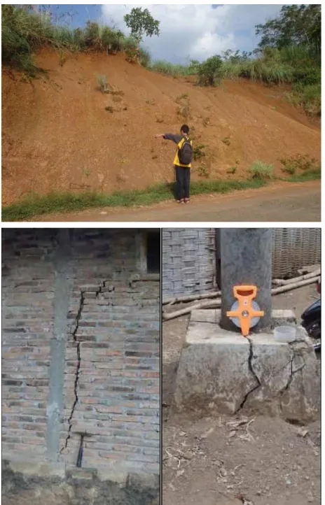
the relatively low population density of the re-search area, development of settlement area in Sidosari area and the surroundings is feasible. However, a number of landslides, including soil creeping, have occurred in Sidosari area and the surroundings and have threatened the lo-cal community (Figure 1). Development of set-tlement area in Sidosari area and the surround-ings requires complete understanding of the en-gineering geological conditions, including sus-ceptibility to soil creeping, to prevent damaged properties and loss of lives.
con-Figure 1: Typical landslides along road cut slopes in the research area and cracks in wall and foundation of houses in Kranjang Lor area induced by soil creeping.
ducted to develop a detailed landslide suscep-tibility map for spatial planning and to identify most controlling factor of landslides in the re-search area based on conditions of geomorphol-ogy, rock and soil, geological structure, ground-water seepage, and land use. The engineer-ing geological conditions of the research area are presented and the most controlling factor of landslides is highlighted.
2 METHODOLOGY
Field and laboratory investigations, involving investigations of conditions of geomorphology, rock and soil, geological structure, groundwa-ter seepage, land use, and susceptibility of the research area to landslide, were conducted dur-ing surface engineerdur-ing geological mappdur-ing at a 1 : 25000 scale. The mapping scale was se-lected since it was a minimum requirement for
urban spatial planning as specified in the Perat-uran Pemerintah Republik Indonesia Nomor 8 Tahun 2013.
Analysis of topographical map, produced by Badan Koordinasi Survey dan Pemetaan Na-sional (2001) using a geographical information system (GIS) tool and field observation of sur-face topography and active geomorphological processes during geomorphical survey were conducted to develop a geomorphological map. The research area was classified into several ge-omorphological units following terrain classifi-cation proposed by Van Zuidam (1983). Slope inclination map was developed following slope classification proposed by Kementerian Energi dan Sumber Daya Mineral (2000). Investiga-tion of rock physical properties and geological structures were conducted and the results were presented in a geological map. Genetic classifi-cation of igneous rocks was conducted follow-ing IUGS classification proposed by Streckeisen (1978), while that of pyroclastic rocks was per-formed following classifications proposed by Schmid (1981) and Fisher (1966). In addition to physical properties and genetic classification, investigation of engineering properties and en-gineering classification of rock and soil were also conducted and the results were presented in an engineering geological map of rocks and soils. Although Dearman (1991) recommended engineering formation to be used as engineer-ing geological unit for medium-scale (1:10000 or greater) map, zonation of engineering ge-ological units in this research was conducted based on lithological type, as per local prac-tice of geological mapping. Weathering degree of rocks was determined by following classifi-cation proposed by ISRM (1981). Strength of intact rocks was determined by the point load method and the field indices recommended by ISRM (1981), while strength of rock masses was estimated by Geological Strength Index (GSI) (Marinoset al., 2004). Classification of soils for engineering purposes was performed by adopt-ing procedures specified by ASTM D2487-11. Soil water content, density, and specific grav-ity were determined by adopting procedures specified by ASTM D2216-10, ASTM D2937-00,
ASTM D854-14, respectively. Shear strength
of the soils was determined by plotting liquid limit (LL) and plasticity index (PI) values in the swelling potential chart proposed by
Dakshana-murty et al. (1973). As groundwater was
con-sidered as one of controlling factors in land-slides, field observation of groundwater seep-age on the slopes was conducted, upon which a map of groundwater seepage intensity was de-veloped. The map of groundwater seepage in-tensity contained classification of groundwater seepage intensity as proposed by Kementrian Pekerjaan Umum (2007). Field observation and interpretations of RBI and satellite image of the existing land uses were conducted to develop a land-use map.
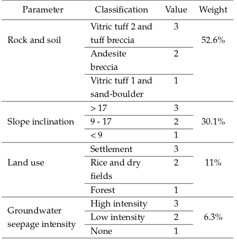
Data of slope inclination, rock and soil, groundwater seepage, and land use were used as parameters in the zonation of landslide sus-ceptibility. Each of the parameters was given a weight based on Analytical Hierarchy Process (AHP) (Saaty, 1990). Criteria for landslide sus-ceptibility zonation are shown in Table 1 and Table 2. The engineering geological unit, slope inclination, land use, and groundwater seepage intensity were given 52.6%, 30.1%, 11%, and 6.3% weights, respectively. Each classification or sub parameter of a parameter was assigned a value from 1 to 3, where the highest value indi-cated the most susceptible parameter to cause a landslide, and a score of each classification was obtained by multiplying the value by the weight. The research area was then divided into three zones of low, moderate, and high landslide susceptibilities.
Table 1: Pairwise comparison matrix in the zonation of landslide susceptibility.
Parameter
inclination 1/2 1 3 5
Land use 1/5 1/3 1 2
Groundwater
seepage 1/7 1/5 1/2 1
3 RESULTS ANDDISCUSSION
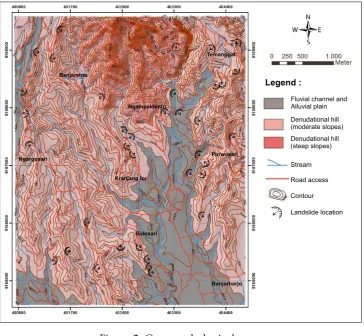
Geomorphological map of the research area is shown in Figure 2, while the slope inclination
Table 2: Criteria for zonation of landslide sus-ceptibility.
Parameter Classification Value Weight
Rock and soil
Vitric tuff 2 and tuff breccia
Vitric tuff 1 and sand-boulder
map is shown in Figure 3. The research area consisted of geomorphological units of fluvial origin, which consisted of alluvial plain and flu-vial channel landforms, and denudational ori-gin, which consists of denudational hill land-forms of moderate and steep slopes. The al-luvial plain and fal-luvial channel landforms had slope inclination ranging from 0 to 9°, while the denudational hill landforms of moderate and steep slopes had slope inclination ranging from 9 to 17° and from 17 to >35°, respectively (Fig-ure 3). Surface geological processes that were active in the denudational hill landforms were mainly erosion, while those in the alluvial plain and fluvial channel landforms were erosion and deposition.
Fluvial channel and Alluvial plain Denudational hill (moderate slopes) Denudational hill (steep slopes)
Stream
Road access
Contour
Landslide location
Ngampeldento
Kranjang lor
Sidosari Banjaretno
Ngargosari Purwosari
Temanggal
Banjarharjo
Legend :
Figure 2: Geomorphological map.
Ngampeldento
Kranjang lor
Sidosari Banjaretno
Ngargosari Purwosari
Temanggal
Banjarharjo
0 - 3 (flat)
Stream
Road access
Contour
3 - 6 (very gentle) 6 - 9 (gentle) 9 - 17 (moderate) 17 - 35 (steep) > 35 (very steep) o
o o
o o
o o
o o
o o
Legend :
to those in the areas having gentler slopes indi-cates slope inclination was not the main control-ling factor of landslides in the research area.
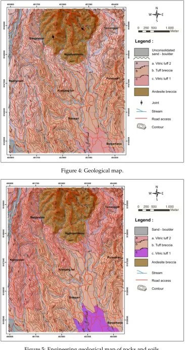
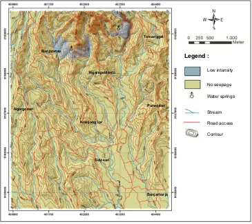
Geological map of the research area is shown in Figure 4. The research area consists of geo-logical units of andesite breccia of Old Sumbing Volcano deposit, vitric tuff 1 of Young Sumbing Volcano deposit, tuff breccia of Young Sumbing Volcano deposit, vitric tuff 2 of Young Sumb-ing Volcano deposit, and unconsolidated sand-boulder deposit. Physical properties of the geo-logical units are described in Table 3. Vitric tuff 1 was essentially coarser than vitric tuff 2 and contained chlorite as a secondary mineral while vitric tuff 2 contained clay as a secondary min-eral. Geological structure observed in the re-search area was tension joints with N 171° E ori-entation developed in the andesite breccia unit. As engineering characteristics of the geolog-ical units were considerably different, the re-search area was also divided into engineering geological units of andesite breccia, vitric tuff 1, tuff breccia, vitric tuff 2, and unconsolidated sand-boulder. Engineering geological units and engineering characteristics of rocks and soils in the research area are shown Figure 5 and Table 3, respectively. In general, the andesite breccia, vitric tuff 1, tuff breccia, and vitric tuff 2 units were highly to completely weathered, had rela-tively low strengths, and were classified as poor quality rock masses. Residual soils of the en-gineering geological units had thickness rang-ing from 1 to 1.5 m and relatively low den-sity and medium to very high swelling poten-tial. Landslides commonly occurred in the ar-eas covered by vitric tuff 2 unit and partly in the areas consisting of the andesite breccia unit. The low cohesion and very high swelling poten-tial of residual soils of the vitric tuff 2 unit were likely responsible for the landslides in the re-search area, including soil creeping in Kranjang Lor. As pointed out by Wesley (2010), residual soils commonly have good bearing capacity for foundation. Due to the low of cohesion, how-ever, residual soil slopes are prone to landslides. Field observation of groundwater seepage in-dicated that two zones of groundwater seep-age existed in the research area (Figure 6). Groundwater mainly seeped through the joints and partly through contacts between moder-ately weathered and residual soil of the andesite
breccia unit, representing permeable and im-permeable layers, respectively, to groundwater flow. While landslides commonly occurred in areas of no groundwater seepage, only a land-slide in Krinjing area (i.e., northwest direction from Temanggal area) associated with the exis-tence of groundwater seepage. This implies that groundwater seepage was not the most control-ling factor of landslides in the research area.
Rice and dry fields were the main land use in the research area, while settlement area was only a small part of the research area (i.e., about 13.3 %) (Figure 7). Landslides most commonly occurred in the settlement areas. Live and dead loads induced soil creeping in Kranjang Lor area having moderate slope inclination. Road cut slopes consisting of low strength soils and rocks in the research area were commonly un-protected and, therefore, prone to failure partic-ularly during rainy seasons.
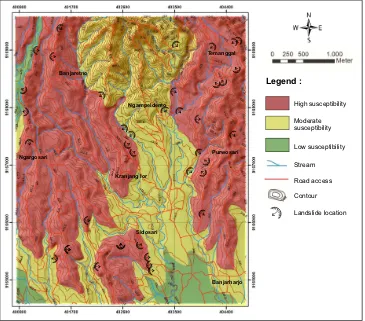
Map of landslide susceptibility is shown in Figure 8. The high susceptibility zone covered approximately 55.5 % of the research area and was characterized by having slope inclinations ranging from 9 to 35°, engineering geological units of vitric tuff 2 and tuff breccia, and land uses of rice and dry fields and settlement. The moderate susceptibility zone consisted 38.3 % of the research area and was characterized by hav-ing slope inclinations ranghav-ing from 6 to >35°, engineering geological units of vitric tuff and tuff breccia units, and all types of land uses in the research area. The low susceptibility zone occupied 6.2 % of the research area and was characterized by having slope inclinations rang-ing from 0 to 17°, engineerrang-ing geological units of vitric tuff 1 and sand-boulder, and land uses of rice and dry fields. Plot of landslide distri-bution (Figure 2) on the landslide susceptibil-ity map (Figure 8) showed that 31 (84 %) land-slides occurred in the high susceptibility zone, 6 (16 %) landslides occurred in the moderate susceptibility zone, and none of landslides oc-curred in the low susceptibility zone. The rea-sonably agreement between landslide distribu-tion and the landslide susceptibility level im-plies that the methodology applied in the land-slide susceptibility zonation was acceptable.
Ngampeldento
Kranjang lor
Sidosari Banjaretno
Ngargosari Purwosari
Temanggal
Banjarharjo
Andesite breccia Unconsolidated sand - boulder
Joint
Stream
Road access
Contour a. Vitric tuff 2 b. Tuff breccia
c. Vitric tuff 1 c
b a
Legend :
Figure 4: Geological map.
Sand - boulder
Stream
Road access
Contour a. Vitric tuff 2 b. Tuff breccia
c. Vitric tuff 1
Andesite breccia c
b a
Ngampeldento
Kranjang lor
Sidosari Banjaretno
Ngargosari Purwosari
Banjarharjo Temanggal
Legend :
Table 3: Engineering characteristics of rocks and soils.
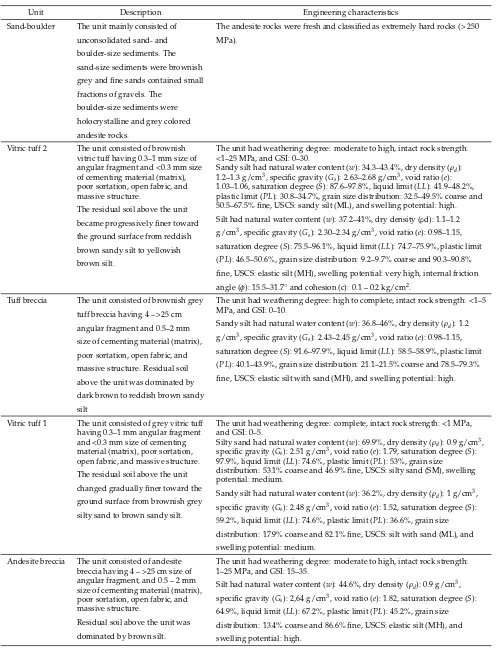
Unit Description Engineering characteristics Sand-boulder The unit mainly consisted of
unconsolidated sand- and boulder-size sediments. The sand-size sediments were brownish grey and fine sands contained small fractions of gravels. The
boulder-size sediments were holocrystalline and grey colored andesite rocks.
The andesite rocks were fresh and classified as extremely hard rocks (> 250 MPa).
Vitric tuff 2 The unit consisted of brownish vitric tuff having 0.3–1 mm size of angular fragment and <0.3 mm size of cementing material (matrix), poor sortation, open fabric, and massive structure.
The residual soil above the unit became progressively finer toward the ground surface from reddish brown sandy silt to yellowish brown silt.
The unit had weathering degree: moderate to high, intact rock strength: <1–25 MPa, and GSI: 0–30.
Sandy silt had natural water content (w): 34.3–43.4%, dry density (ρd):
1.2–1.3 g/cm3, specific gravity (G
s): 2.63–2.68 g/cm3, void ratio (e):
1.03–1.06, saturation degree (S): 87.6–97.8%, liquid limit (LL): 41.9–48.2%, plastic limit (PL): 30.8–34.7%, grain size distribution: 32.5–49.5% coarse and 50.5–67.5% fine, USCS: sandy silt (ML), and swelling potential: high. Silt had natural water content (w): 37.2–41%, dry density (ρd): 1.1–1.2
g/cm3, specific gravity (Gs): 2.30–2.34 g/cm3, void ratio (e): 0.98–1.15,
saturation degree (S): 75.5–96.1%, liquid limit (LL): 74.7–75.9%, plastic limit (PL): 46.5–50.6%, grain size distribution: 9.2–9.7% coarse and 90.3–90.8% fine, USCS: elastic silt (MH), swelling potential: very high, internal friction angle (φ): 15.5–31.7◦and cohesion (c): 0.1 – 0.2 kg/cm2.
Tuff breccia The unit consisted of brownish grey tuff breccia having 4 – >25 cm angular fragment and 0.5–2 mm size of cementing material (matrix), poor sortation, open fabric, and massive structure. Residual soil above the unit was dominated by dark brown to reddish brown sandy silt
The unit had weathering degree: high to complete, intact rock strength: <1–5 MPa, and GSI: 0–10.
Sandy silt had natural water content (w): 36.8–46%, dry density (ρd): 1.2
g/cm3, specific gravity (Gs): 2.43–2.45 g/cm3, void ratio (e): 0.98–1.15,
saturation degree (S): 91.6–97.9%, liquid limit (LL): 58.5–58.9%, plastic limit (PL): 40.1–43.9%, grain size distribution: 21.1–21.5% coarse and 78.5–79.3% fine, USCS: elastic silt with sand (MH), and swelling potential: high.
Vitric tuff 1 The unit consisted of grey vitric tuff having 0.3–1 mm angular fragment and <0.3 mm size of cementing material (matrix), poor sortation, open fabric, and massive structure. The residual soil above the unit changed gradually finer toward the ground surface from brownish grey silty sand to brown sandy silt.
The unit had weathering degree: complete, intact rock strength: <1 MPa, and GSI: 0–5.
Silty sand had natural water content (w): 69.9%, dry density (ρd): 0.9 g/cm3,
specific gravity (Gs): 2.51 g/cm3, void ratio (e): 1.79, saturation degree (S):
97.9%, liquid limit (LL): 74.6%, plastic limit (PL): 53%, grain size distribution: 53.1% coarse and 46.9% fine, USCS: silty sand (SM), swelling potential: medium.
Sandy silt had natural water content (w): 36.2%, dry density (ρd): 1 g/cm3,
specific gravity (Gs): 2.48 g/cm3, void ratio (e): 1.52, saturation degree (S):
59.2%, liquid limit (LL): 74.6%, plastic limit (PL): 36.6%, grain size distribution: 17.9% coarse and 82.1% fine, USCS: silt with sand (ML), and swelling potential: medium.
Andesite breccia The unit consisted of andesite breccia having 4 – >25 cm size of angular fragment, and 0.5 – 2 mm size of cementing material (matrix), poor sortation, open fabric, and massive structure.
Residual soil above the unit was dominated by brown silt.
The unit had weathering degree: moderate to high, intact rock strength: 1–25 MPa, and GSI: 15–35.
Silt had natural water content (w): 44.6%, dry density (ρd): 0.9 g/cm3,
specific gravity (Gs): 2,64 g/cm3, void ratio (e): 1.82, saturation degree (S):
Road access
Contour Stream Water springs No seepage Low intensity
Ngampeldento
Kranjang lor
Sidosari Banjaretno
Ngargosari Purwosari
Temanggal
Banjarharjo
Legend :
Figure 6: Map of groundwater seepage intensity.
Ngampeldento
Kranjang lor
Sidosari Banjaretno
Ngargosari Purwosari
Temanggal
Banjarharjo
Forest
Stream
Road access
Contour Settlement Dry field
Rice field
Legend :
Ngampeldento
Kranjang lor
Sidosari Banjaretno
Ngargosari Purwosari
Temanggal
Banjarharjo
Road access
Contour
Landslide location Stream Low susceptibility Moderate susceptibility High susceptibility
Legend :
Figure 8: Map of landslide susceptibility.
case of Kranjang Lor area, due to the relatively low strength of soils and rocks consisting the re-search area, mass movement may occur in areas having gentle slopes.
4 CONCLUSION
Engineering geological mapping at a 1:25000 scale was conducted to develop a detailed land-slide susceptibility map and to identify most controlling factor of landslides in the research area. Landslides, including soil creeping, com-monly occurred in the moderate slopes of the denudational hill landform having slope incli-nation ranging from 9 to 17°, in the areas cov-ered by residual soils of the vitric tuff 2 unit, in the areas of no groundwater seepage, and in the settlement areas, including in Kranjang Lor area where soil creeping occurred. The high suscep-tibility zone covered 55.5 % of the research area and was characterized by having slope inclina-tions ranging from 9 to 35°, engineering geolog-ical units of vitric tuff 2 and tuff breccia, and land uses of rice and dry fields and settlement. The low cohesion and very high swelling poten-tial of the residual soils of the vitric tuff 2 unit
were considered to be the main controlling fac-tor of landslides in the research area.
ACKNOWLEDGEMENTS
The research was supported by Department of Geological Engineering Universitas Gadjah Mada. The assistance of Ms. Tran Thi Thanh Thuy during the field and laboratory investiga-tions is gratefully acknowledged.
REFERENCES
ASTM D854-14, Standard Test Methods for Spe-cific Gravity of Soil Solids by Water Pycnome-ter, ASTM International, West Conshohocken, PA, 2014.
ASTM D2216-10, Standard Test Methods for Labora-tory Determination of Water (Moisture) Content of Soil and Rock by Mass, ASTM International, West Conshohocken, PA, 2010.
ASTM D2487-11, Standard Practice for Classification of Soils for Engineering Purposes (Unified Soil Classification System), ASTM International, West Conshohocken, PA, 2011.
ASTM D3080-98, Standard Test Method for Di-rect Shear Test of Soils Under Consolidated Drained Conditions, ASTM International, West Conshohocken, PA, 1998.
Badan Koordinasi Survey dan Pemetaan Nasional (2001) Peta Rupa Bumi Digital Indonesia Lembar 1408-234 Mungkid, Bogor, BAKOSURTANAL. Barker, A.J. (2014) A Key for Identification of
Rock-forming Minerals in Thin-Section, UK, University of Southampton.
Dakshanamurty, V., Raman, V. (1973) A simple method of identifying an expansive soil, Soils and Foundations: Japanese Society of SMFE, 13. 1, March.
Dearman, W.R. (1991) Engineering Geological Map-ping, Oxford, Butterworth-Heinemann Ltd. Fisher, R.V. (1966) Rocks composed of volcanic
frag-ments and their classification, Amsterdam, Else-vier Publishing Company.
ISRM (1981) The Complete ISRM Suggested Meth-ods for Rock Characterization, Testing and Moni-toring, Ankara, ISRM Turkish National Group. Kementerian Energi dan Sumber Daya Mineral
(2000) Keputusan Menteri Energi dan Sumber Daya Mineral Nomor 1452 K/10/MEM/2000 ten-tang Pedoman Teknis Pemetaan Zona Kerentanan Gerakan Tanah, Jakarta, Departemen Energi dan Sumber Daya Mineral.
Kementrian Pekerjaan Umum (2007) Pedoman Pe-nataan Ruang Kawasan Rawan Bencana Long-sor. Peraturan Menteri Pekerjaan Umum No. 22/PRT/M/2007, Jakarta, Departemen Pekerjaan Umum, Direktorat Jenderal Penataan Ruang. Marinos, V., Marinos, P., Hoek, E. (2004) The
geo-logical strength index : applications and limita-tions, Athens, School of Civil Engineering, Na-tional Technical University of Athens.
Novianto, M.W.A., Djaja, Wahyudin (1997) Peta Geologi Teknik Lembar Yogyakarta, Skala 1 : 100.000, Bandung, Direktorat Geologi Tata Lingkungan.
Pusat Vulkanologi dan Mitigasi Bencana Geologi (2015) Peta Zona Kerentanan Gerakan Tanah Kota dan Kabupaten Magelang, Provinsi Jawa Tengah, Jakarta, Kementerian Energi dan Sumber Daya Mineral.
Rahardjo, W., Sukandarrumidi, Rosidi, H.M.D. (1995) Peta Geologi Lembar Yogyakarta, Skala 1 : 100.000, Bandung, Pusat Penelitian dan Pengem-bangan Geologi.
Saaty, T.L. (1990) How to make a decision: The Anal-ityc Hierarchy Proces, European Journal of Op-erational Research 48, Pittsburgh, University of Pittsburgh.
Schmid, R. (1981) Descriptive nomenclature and classification of pyroclastic deposits and frag-ments: Recommendations of the IUGS Subcom-mision on the Systematics of Igneous Rocks, Zürich, Springer-Verlag.
Streckeisen, A., (1989) A Classification of Igneous Rocks and Glossary of Terms: Recommendations of the International Union of Geological Sciences Subcommission on the Systematics of Igneous Rocks, Cambridge, Cambridge University Press.
Van Zuidam, R. A. (1985) Aerial