Lokasi Proyek POKJA REDD+ IJ-REDD+
Pontianak Kubu Raya Ketapang Kayong Utara Four Districts (Sub-sub-National) GPNP Provincial (= Sub-National) Lokasi Project (TN Gunung Palung) 1 IJ-REDD+ dilakukankegiatan REDD+ pada 3 skala diatas
Establishing a monitoring plan
REDD+ Activities in Sub-national and Project Scale
n REDD+ activities are conducted in both Sub-national and Project scales.
n Consistency of both scales should be kept, and consistency with National scale should be also considered.
Reference Level (RL)
Actual CO2 Emission
CO2 Emission Reduction Time (year) C O 2 Emi ssi on
CO2 Emission in the past
Identifying drivers of def. and forest deg.
Collecting data on historical land use and carbon stock
Deciding potential REDD+ sites (only 4 districts)
Establishing Reference Level (RL)
Providing training on GIS, and so on
e.g. IPCC Guidelines
e.g. Forest Fires
Land cover map, Regula2on map, …
Ecosystem/Landscape REDD+
n Dengan mempertimabgkan kegiatan masyarakat dan juga konsrvasid alam arti luas, kali ingin menerapkan kegiatan REDD+ pada level ekosistem atau
landscape (bentang alam )
3 Kadangkala kegiatan masyarakat harus di
alihkan keluar TNGP (misalnya ke HL atau yg lainnya).
Degradation
Degradation
Untuk mengkonservasi ekosistem secara terintegrasi melalui kegiatan REDD+ dgn pendekatan bentang alam perlu
Concept of Forest Monitoring
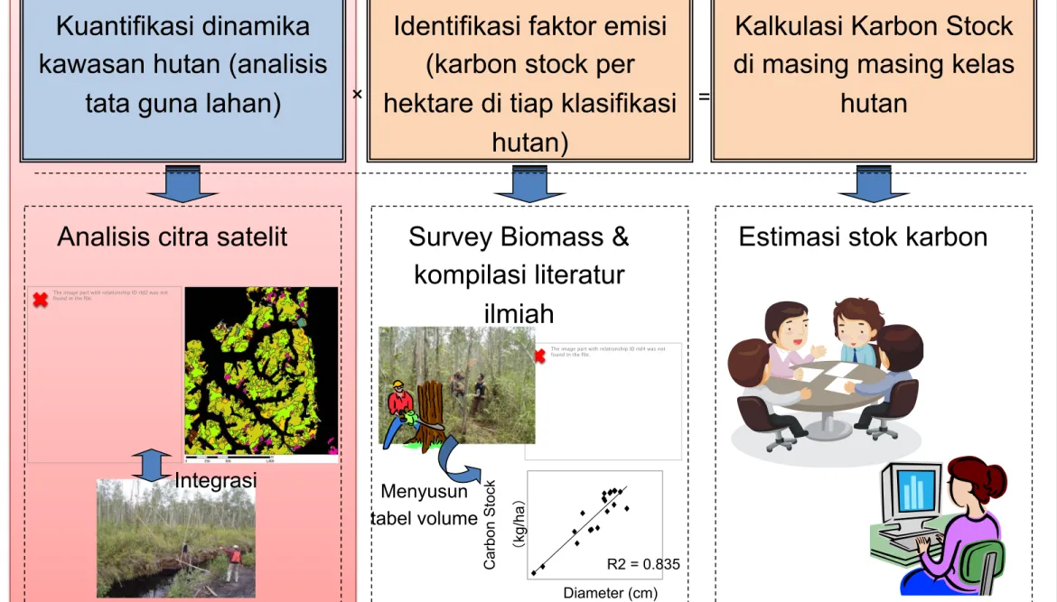
5 Kuantifikasi dinamika
kawasan hutan (analisis tata guna lahan)
Identifikasi faktor emisi (karbon stock per hektare di tiap klasifikasi
hutan)
× =
Analisis citra satelit Survey Biomass & kompilasi literatur
ilmiah
Estimasi stok karbon
R2 = 0.835 Diameter (cm) C arb on St ock (kg /h a )
The image part with relationship ID rId2 was not found in the file.
The image part with relationship ID rId4 was not found in the file.
Integrasi Menyusun
tabel volume
Kalkulasi Karbon Stock di masing masing kelas
Land-cover Map Improvement
Pontianak Kubu Raya Ketapang Kayong Utara TNGPMembangun metodologi yg akurat dlm
mengklasifikasi tutup lahan dgn mempergunakan citra sateliti resolusi tinggi (SPOT 6) dan citra
LADSAT, dan mempersiapkan klasifikasi tutupan di TNGP.
Dengan menerapkan meteodologi di atas, secara umum klasifikasi tutup lahan 4 kabupaten dgn dasar LANDSAT dapat di perbaiki.
Perbaikan Peta (image) Peta saat ini
7
9
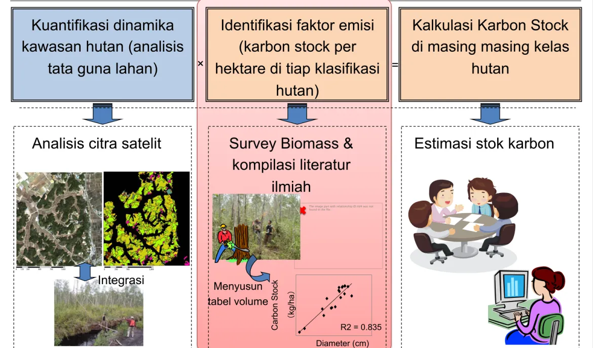
Concept of Forest Monitoring
Kuantifikasi dinamika kawasan hutan (analisis
tata guna lahan)
Identifikasi faktor emisi (karbon stock per hektare di tiap klasifikasi
hutan)
× =
Analisis citra satelit Survey Biomass & kompilasi literatur
ilmiah
Estimasi stok karbon
R2 = 0.835 Diameter (cm) C arb on St ock (kg /h a )
The image part with relationship ID rId4 was not found in the file.
Integrasi Menyusun
tabel volume
Kalkulasi Karbon Stock di masing masing kelas
(Reference) Usulan kalsifikasi tutupan lahan Class di IJ-REDD+
13 No
. Forest Inventory of Ministry of Forestry, Indonesia Kalimantan Province RAD-GRK of West Four district under IJ-REDD+ GPNP under IJ-REDD+
1 Hutan Lahan Kering Primer (Primary Dry Land Forest) Primary Dry land forest Primary Dry Land Forest
Primary Dry Land Forest_high Primary Dry Land
Forest_middle
Primary Dry Land Forest_low
2 Hutan Lahan Kering Sekunder (Secondary Dry Land Forest) Secondary Dry land forest
Secondary Dry Land
Forest_high Secondary Dry Land Forest
Secondary Dry Land Forest_low
Secondary Dry Land Forest_ logging
Secondary Dry Land Forest_ fire
3 Hutan Mangrove Primer (Primary Mangrove Forest) Primary Mangrove forest Primary Mangrove Forest Primary Mangrove Forest 4 Hutan Rawa Primer (Primary Swamp Forest) Primary Peat swamp forest Primary Swamp Forest Primary Swamp Forest 5 Hutan Tamanan (Plants Forest) Plantation forest
Plants Forest_Type A Plants Forest_Type A
Plants Forest_Type B Plants Forest_Type B
Plants Forest_Type C Plants Forest_Type C
catatan 1: warna merah klasifikasi hutan akan di identikasi oleh IJ-REDD+ untuk evaluasi perubahan karbon stok.
catatan 2: Hutan rawa telah di deteksi di analisis kami sebab hutan gambut dapat di kalisifikasikan berdasarkan karakteristik warna dan tekstur dengan mempergunakan citra satelit, sedangkan hutan gambut lebih sulit di deteksi.
(Reference) Usulan kalsifikasi tutupan lahan Class di IJ-REDD+
14 No
. Forest Inventory of Ministry of Forestry, Indonesia
RAD-GRK of West Kalimantan Province
Four district under
IJ-REDD+ GPNP under IJ-REDD+
6 Semak Belukar (Shrubs) Bushes Shrubs Shrubs
7 Perkebunan (Plantation Area) Plantation
Plantation_Type A Plantation_Type A
Plantation_Type B Plantation_Type B
Plantation_Type C Plantation_Type C
8 Permukiman (Settlements) Buikt up areas Settlements Settlements 9 Tanah Terbuka (Open Ground) Bare Open Ground Open Ground 10 Rumput (Grass) Integrated (to be checked) Grass Grass
11 Air (Water) Water Water Water
12 Hutan Mangrove Sekunder (Secondary Mangrove Forest) Secondary Mangrove forest Secondary Mangrove Secondary Mangrove 13 Hutan Rawa Sekunder (Secondary Swamp Forest) Secondary Peat swamp forest Secondary Swamp Forest Secondary Swamp Forest 14 Belukar Rawa (Swamp Shrub) Integrated (to be checked) Swamp Shrub Swamp Shrub
15 Pertanian Lahan Kering (Dryland Agriculture) Integrated (to be checked) Dryland Agriculture Dryland Agriculture 16
Pertanian Lahan Kering Campur (Mixed Dryland Agriculture)
Integrated (to be checked) Mixed Dryland Agriculture Mixed Dryland Agriculture
catatan 1: warna merah klasifikasi hutan akan di identikasi oleh IJ-REDD+ untuk evaluasi perubahan catatan 2: Semak belukar adalah lahan yang terdiri semak yang tumbuh cukup besar dengan kanopi lebih dari 5m
catatan 3: perkebunan tanaman berkayu seperti kelapa sawit, karet, kopi, teh, kelapa, coklat dan lain lain..
catatan 4: Padang rumput terdiri atas beragam type rumput dan padang alang alang.
catatan 5: pertanian lahan kering mencakup beragam komiditi seperti padi, jagung, nenas dan sayuran. catatan 6: Agroforestry ditutupi dengan tanaman tahunan campuran dengan waktu penanaman yang
(Reference) Usulan kalsifikasi tutupan lahan Class di IJ-REDD+
15 Forest Inventory of Ministry
of Forestry, Indonesia
RAD-GRK of West Kalimantan Province
Four district under
IJ-REDD+ GPNP under IJ-REDD+ 17 Sawah (Rice Field) Integrated (to be checked) Rice Field Rice Field
18 Tambak (Dikes) Integrated (to be checked) Fishpond Fishpond
19 Bandara/Pelabuhan (Airport/Port) Integrated (to be checked) To be considered To be considered 20 Transmigrasi (Transmigration Area) Integrated (to be checked) To be considered To be considered 21 Pertambangan (Mining Area) Integrated (to be checked) Mining Mining
22 Rawa (Swamp Bush) Integrated (to be checked) Swamp Swamp
Future works
l Hutan lahan kering, hutan mangrove dan hutan rawa tidak diklasifikasikan sebagai hutan primer dan sekonder saat ini. Untuk selanjutnya akan
diklasifikasi sebagai hutan primer dan hutan sekunder dengan
mempergunakan spectral indexThey are going to be classified to primary and secondary using some spectral index, tambahan data GIS data atau sesuai kebutuhan spatial.
Karbon Stock di masing masing tutupan lahan
4 distrik lokasi proyek
IJ-REDD+ IJ-REDD+ di TNGP
1 Primary Dry Land Forest
Primary Dry Land Forest_1 Primary Dry Land Forest_2 Primary Dry Land Forest_3
2
Secondary Dry Land Forest_1 Secondary Dry Land Forest_1
Secondary Dry Land Forest_2
Secondary Dry Land Forest_ logging
Secondary Dry Land Forest_ fire
3 Primary Mangrove Forest Primary Mangrove Forest
4 Primary Swamp Forest Primary Swamp Forest
12 Secondary Mangrove Forest Secondary Mangrove Forest
13 Secondary Swamp Forest Secondary Swamp Forest
n “Values” of carbon stock in each land-cover are from “National Inventory”, “RAG-GRK”, “IPCC
EFDB” or “specific data will be obtained by IJ-REDD+”. Under preparation 195.4 t-C/ha 169.7 t-C/ha XXX t-C/ha XXX t-C/ha XXX t-C/ha XXX t-C/ha 170.0 t-C/ha 196.0 t-C/ha XXX t-C/ha XXX t-C/ha
(Reference) Penerapan Kalasifikasi hutan dan lahan
1. Peta Topograpi (1:250,000-1:10,000) 2. Peta Geologi (1:250,000-1:10,000) 3. Peta Tanah (1:250,000-1:10,000) 4. Citra Satelit
(1) Landsat-5/-7 Images (2000-2002, sebelum 1995) (2) SRTM (2000)
(3) Landsat-1/-3 Images (1970s)
5. Peta Tata guna lahan (1:250,000-1:10,000) 6. Peta Konsesi / Ijin
(1) Kelapa Sawit, Hutan Produksi, dll. (2) Peta Eksplorasi Mineral & Tambang 7. Lain Lain
Data yang dipergunakan untuk memperbaiki Peta Lahan Gambut
Perbaikan Peta Lahan Gambut
Identifikasi Potential REDD+ sites (Kerangka Kerja)
21 LU / LC map Year 2000 LU / LC map Year 2013 LU / LC analisis perubahan tipe lahanMengidentifikasi deforestasi yg tinggi dan sisi hutan tersisa.
Kriteria Socio Economic
Survey lapangan / wawancara dengan
para pihak
l Kegiatan konservasi yg telah ada atau kegiatan konservasi di masa depan.
l Batas area jelas (tidak ada konflik tentang tataguna lahan)
l Mendapat kerjasama dari pemerintah lokal, masyarakat dll. l Berdampak tinggi melakui
kolaborasi dengan hasil kerja output 2
l Mengantisipasi praktek pemanfaatn sebagai “praktek yang baik”
Konsultasi dengan stakeholder
Pemilihan lokasi pilot
REDD+ Kegiatan model di lokasi pilot Landuse Map
l Hutan Lidung l Hutan Konservasi
l Hutan Produksi yang belum di bebani hak l Hutan alam yang masih tersisa sebagai HCVF idi
area konsesi HP
l Hutan alam yang masih tersisa di APL (Plantation area)
<Estimated Potential Site>
Peta Moratorium
Take into account of human resources in relevant insitution
Rencana Kedepan
n Membangun kelembagaan REDD+ Kalimantan Barat
n Meningkatkan kapasitas staf teknis (BLH, Bappeda,
Dinas Kehutanan dan UPT Kemenhut) untuk menghitung
MRV/REL Kalbar
n Membangun kerjasama dengan BP-REDD untuk
mengaplikasikan dokumen SRAP REDD+ Kalimantan
Barat.
Pontianak
Kubu Raya
Ketapang GPNP West Kalimantan Province Overall Indonesia
GPNP
Four Districts
Provincial Government Central Government
National REDD+ Strategy
2000 2006 2009 2011 2013
LANDSAT + RAD-GRK classes + land-use map + peat map + α Sub-national lebel_Output 1
Project level_Output 2
LANDSAT + RAD-GRK classes + land-use map + peat map + α
2000 2006 2009 2011 Socio-economic Survey
REDD+ Potential Map
Project Design Document (PDD)
Materials for Output3 National level_Output 5
Direction of Monitoring Structure and Plan
Kayong Utara
1. Improving land-cover map preparation methods
2. Improving current land-cover map 3. Considering consistency among