LETTER OF TRANSMITTAL
CONTENTS
Slope of original mound, a, View of slabs on slope; tip of post in foreground, b, Close-up of plates in place.
THE TROYVILLE MOUNDS, CATAHOULA
PARISH, LA
INTRODUCTION
Therefore, they reluctantly agreed to any excavation of the site at all, and then only on the assumption that such "money" found would belong to them by right. WALKER] TEOYVILLE, LA., MOUNDS 6 and for the use of maps and equipment the expedition is indebted to Mr. Acknowledgment is also made to members of the staff of the United States National Museum and members of the Division of Chemistry and Earth and the United States Bureau of Biology. Department of Agriculture for correct identification of collected material.
LOCATION
Many of the townspeople were called upon for information and even for the loan of tools and equipment, all of which were provided with hearty goodwill. This results in annual high tides which, prior to the building of the levees, deposited successive layers of sand, clay and silt that formed the rich "gumbo" soil of the lowlands. It is curious to find that these low marshy bottomlands of the Tensas Basin may have had a larger population in primitive times than they have today, judging from the large number of artificial mounds and earthworks found along all the principal streams.
DISCOVEEY AND EAELY INVESTIGATIONS
Not having time to examine the group carefully on that occasion, Dunbar proposed to do so on his return, which he did on January 21 of the following year. His theory was that some of the earthworks were for defense and that the mounds were built 'for the reception of the dead'. Since the French 'motley' is equivalent to a fraction more than an English foot, this map provided another confirmatory check on the height of the large mound.
CONCORDIA PARISH
Beyer, although he dug a little in some of the other mounds, devoted most of his attention to the Great Mound, which he says Prof. Most of the other mounds have already served the purpose of house foundations or have been cleared for other buildings. Remains of the other mounds were seen, most of which served as foundations for houses in the town.
EXCAVATIONS IN 1931-32 Great Mound Site
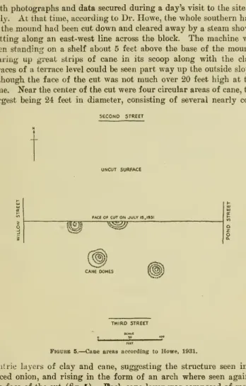
Even the 5-foot level was scraped down until not even the outlines of the bottom remained. 7, in front of the Magnolia Hotel, which afforded an unobstructed view of the three rivers, was gone by two-thirds, leaving a high, steep wall overlooking the Black River. The trenching technique was necessary because no mound was actually visible, not even the outline of the area it had previously occupied.
THIRD STREET
This part of the excavation required six weeks before the contents of the escarpment could be satisfactorily exposed, outlined and photographed. There was nothing present but the calvarium; face, lower jaw and all other bones of the skeleton were missing. In the longitudinal direction of the platform, but on the outside of the poles, were two tree trunks of approximately 3 meters long, which, however, were not directly against the poles.
But beyond the pile of logs only a single stage of fire remained, proving that the logs were laid at the very bottom of the original slope of the mound. The only other interesting feature in this part of the site was the presence of finely woven pieces, which were at two points on the southern slope. This stump shows that it was cut down and burned before the mound was raised.
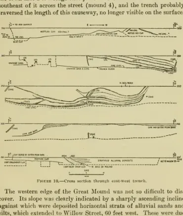
Taking advantage of this offer, a trench was dug on top of the slope at the northern edge of the mound. The long ridge that encloses two sides of the town is what remains of the old causeway at Dunbarand Hunter. There were traces of bones and shells in the floor of the trench, which was directly below the top.
2 was excavated further west, along a proper east-west line, along a wider part of the embankment.
MATEEIAL CULTURE
In the accumulated debris from the fire level at the base of Den Great Høj, the predominant type of pottery was decorated in the style of the Hopewell pottery, with curved bands or figures bounded by broad grooves and adjacent areas uniformly roughened by means of theroulette or fine punctures . A few specimens of the "overhang" type of parallel cantilevers found by Collins at the prehistoric Deasonville site in Mississippi^^ are also presented at Jonesville. But all the Jonesville pottery, as has been stated, possesses a varying amount of sand and particles, which, when present in large quantities, give the pottery and consequently feel the surface softer than that of the other variety from the same place which has only traces of sand.
The roulette variety is that associated with the Hopewell-type pottery found at the bottom of the Great Mound, and is also found at some of the other sites. Moreover, it bears a striking resemblance to the pottery found by McKern in the TrempealeauMoundsofWisconsin.^' Theothervariety, also characteristic of Hopewell, that of closely compressed zigzags appearing in outline in some cases from the grooveli line, was very widespread . WALKBK] TROYVILLE, LA., MOUNDS 43 cord-wrapped sticks are present, distinguished primarily by the size and shape of the interstices left between the cord marks.
It is tempered in chips and sand, but does not have the "sand feel" of the other variety, and is also harder and less smooth. Pottery known to have been made by the Natchitoches-Ouachita section of the Caddo, although found further up the river itself, does not occur at Jonesville. Some of the same varieties are found westward up the Little River, north a short distance down the Ouachita River, and eastward to the Mississippi.
It is very similar to certain of the Marksville vessels, as already mentioned, but differs just enough to be considered a variant rather than a typical form.
CONSTRUCTION MATERIALS
So far as is known, this occurrence cannot be regarded as a reliable determination of the age of the deposits in which it is found, nor can it be proved that the aborigines made any deliberate use of a dye. The conclusion reached by the investigators was that all the various colored earths used in the construction of the mound were probably taken from a short distance, so that no unusual amount of labor would have been required to transport them. Specimens of cane layers, bark and plate fragments, logs, posts and poles were saved from the various parts of the Great Mound .. the place where they were uncovered and were sent for identification to Mr.W.N.Watkins, Assistant Curator. Section of Wood Technology, United States National Museum.
Watkin also consulted Dr. S. J. Record, professor of forest products, Yale University School of Forestry, and although the structure of the forest was in most cases badly distorted by the heavy weight of wet clay that covered it, the following forests were identified : from the outside. southern cypress {Tax- odiumdistichum), chinquapin {Castanea pumila), red {Liquid- ambarstyracvfiua)^ black willow {Salix nigra)^ash {Fraxinussp.), black locust {Rohinia pseudoacacia), hickory {Hicoria sp.), the tree. The attempt was further made to determine whether any of these trees presented a record of growth sufficiently preserved in rings to indicate at what period of time they were cut and placed around the original GreatMound. For this purpose, sections of the best samples of logs and posts were sent to the dendro-chronological laboratory of Dr. A. E. Douglass at the University of Arizona, Tucson, and here answered an insubstance that the work of studying the changes of growth in their trees could still have turned up in such an error. eventually successfully in the Southwest , but thought, however, that the cypress, and perhaps the yellow pine and chinqua-.
He . also suggested that archaeologists working in the valley region should take sections of living trees if possible, to compare with any forests that might be in the hills. The sugar cane was entirely of the common marsh variety {Arundinari The onlookers presented several theories to explain the presence of the stick in the Great Mound, but none seemed to satisfactorily explain this unusual feature. Joseph at that time, in 1543, was part of the main channel of the Mississippi and was subsequently cut off, thus forming the present Oxbowlake. In the description of the Taensa village and its temple there are several analogies with certain features found at the Troyville Hills. It is most likely that it is in one or more of the early stages of the construction of the hill. The Avoyel was the other tribe that probably influenced the culture of the Troyville Indians in some way. Two of the most distinguished students of De Soto's route west of the Mississippi, Dr. Nevertheless, the inhabitants bravely contested the passage of the river, but when they saw it. The subjects of Guachoia entered with fury, plundered and plundered the temple everywhere, as the tomb of the lords of the province, with the wealth of Anilko. But the men of this cacique removed these heads and quickly replaced them with those of some of Anilko's subjects. Therefore, on the 5th of the following month (June or July) they left Guachoya and headed west. The route of the Spaniards took them to Texas at the river which they called "Daycao," perhaps the Trinity. As to the direction of the migration or spread of these people, the writer inclines to the theory that the Hopewellians were originally a southern tribe, or perhaps a stock, which spread over the valley of the Mississippi and some of its tributaries, and finally reached the Scioto valley of Ohio, where they settled and until the highest levels developed their own distinctive culture. But while this type of pottery is invariably associated with unmistakable prehistoric activity in both sections, the precise interrelationship of the two aspects of the Hopewell culture must await a more detailed investigation of the intermediate Mississippi Valley. The trash and weeds were burned again until only the stumps of the double walnut trees remained, which were soon covered by a pile of earth. A little further along the foot of the slope, logs were laid in heaps, each of which had been carefully cut and trimmed at both ends. On the west side of the slope, a stepped approach was built in a gentle slope. The GreatMound may have reached a height of 45 feet by the time De Soto and his Spaniards discovered the great capital of the populous province of Anilco. A temple is also described, in which the bones of the chiefs of Anilco and other sacred relics were deposited in coffin-baskets, and this building was closed by a row of pikes, which were impaled with the heads of captured enemies. After the final departure of the Spanish, possibly to serve as a watchtower to warn against other invaders, the large truncated cone may have been added to the double-terraced base. But by a somewhat dubious strategy, the French succeeded in getting possession of their Great Sun and some of his leading men, and thus forced the surrender of the fort. Erosion trenches and dynamite accelerated the process of decomposition until the last visible remnant of the mound, which was once perhaps the tallest in the South and second in elevation only to the great Cahokia Mound in Illinois, disappeared in 1931 under the relentless activity of steam shovels, scrapers and gangs of pickaxe workers. REFEKENCES CITED INDEX Gabciiaso de ia Vega — Con. pageCULTUKAL HISTOKY
CONCLUSIONS
70 INDEX

