HOLOCENE ENVIRONMENTAL CHANGES
DERIVED FROM A MONTANE POLLEN SEQUENCE IN THE KWAZULU-NATAL MIDLANDS,
SOUTH AFRICA
by Anél Geer
Submitted in fulfilment of the academic requirements
for the degree of Master of Science in the Discipline of Geography School Agricultural, Earth and Environmental Sciences
University of KwaZulu-Natal Pietermaritzburg
April 2013
i
ii
ABSTRACT
There is a limited understanding of the climatic history of summer rainfall regions of South Africa, especially the east coast, even though palaeo-research has become a popular technique used in southern Africa to determine past environmental and climatic changes.
Sites such as wetlands and peatlands are ideal for palaeo-environmental research as they are of high organic content and enable pollen preservation. Dartmoor Vlei, situated at Mt.
Gilboa, KwaZulu-Natal, is surrounded by Midlands Mistbelt grassland and in close proximity of the Karkloof Forest archipelago, rendering the site ideal for investigating grassland/forest dynamics. A minimally disturbed, 240 cm, organic rich sediment core was obtained from Dartmoor Vlei for analyses. A multi-proxy approach, viz. radiocarbon, charcoal, geochemical (carbon and nitrogen stable isotopes) and palynological analyses, was adopted to determine past environmental changes. Six samples were used for AMS radiocarbon dating, which indicates sediments date back ca. 12,200 cal yr BP at 144 cm. Environmental conditions at Dartmoor Vlei during the early Holocene are characterised by warmer, dry conditions, and arboreal pollen taxa are found in high concentrations between ca. 12,300 and 9000 cal yr BP. The mid-Holocene marks a period where systematic changes begin to occur at Dartmoor Vlei, as wetter conditions in accordance with the Holocene Altithermal are evident ca. 8000 cal yr BP. A period of locally drier conditions at ca. 6000 cal yr BP is followed by a decrease in arboreal taxa such as Podocarpus, Brassicaceae, Anacardiaceae and Celtis at ca. 5800 cal yr BP. The occurance of Zea mays in the record at ca. 1600 cal yr BP, the increase in fire intensity and frequency, and subsequent decrease in some arboreal taxa is a robust indication of anthropogenic activity in the KwaZulu-Natal Midlands region, attributed to Iron Age settlers. Arboreal and grassland pollen signals indicate the existence of a mosaic of montane and sub-alpine grassland and montane forests in the region of Dartmoor Vlei throughout the Holocene, and at present.
iii
PREFACE
The experimental work described in this dissertation was carried out in the School of Agricultural, Earth and Environmental Sciences, University of KwaZulu-Natal, Pietermaritzburg, from January 2010 to February 2013, under the supervision of Prof T.R.
Hill and Dr J.M. Finch.
These studies represent original work by the author and have not otherwise been submitted in any form of degree or diploma to any University. Where use has been made of the work of others it is duly acknowledged in the text.
A. Geer (candidate) Date
Prof T.R. Hill Date
Dr J.M. Finch Date
iv
ACKNOWLEDGEMENTS
To my supervisors, Prof. Trevor Hill and Dr. Jemma Finch a heartfelt thanks for sparking my interest in palaeo-research and for your time and continuous support, it is truly appreciated.
To my fellow pollen-man, Jared Lodder, for all your help and advice, you are a star, and to my friends, Imke, Paul, Dom and Liandra, who braved the great outdoors to help me with my fieldwork, you guys were amazing.
Thank you to the Palaeontological Scientific Trust (PAST) and the SANBI Grasslands Programme for the financial assistance which made this research possible.
To the Electron Microscopy Unit (UKZN) for the use of their facilities and the Stable Light Isotope Laboratory (UCT) for conducting the Stable Light Isotope Analysis. The University of Waikato and Beta Analytic Laboratories for conducting Radiocarbon Dating. To the Grassland Science Department (UKZN) for allowing me to use their laboratory facilities, and to the Soil Science Department (UKZN) for the use of their equipment. To Astika Bhugeloo (UKZN) for conducting charcoal counts. To Desiree Lamoral at the Institute for Commercial Forestry Research Library for her assistance with reference material. To Colin Holmes, Victor Bangamwabo and Brice Gijsbertsen (UKZN) for their assistance with GIS. To the Van Zuydam family of Dartmoor Vlei for allowing me to carry out the research on their property and allowing me access to the site.
And to family, thank you for your continuous support and encouragement throughout my work, without you this thesis would not have been possible.
v
TABLE OF CONTENTS
1. INTRODUCTION………1
1.1 Introduction……….………1
1.2 Aim and objectives………..4
1.3 Thesis outline…….………..5
2. REVIEW OF SOUTH AFRICAN PALAEO-ENVIRONMENTAL HISTORY……..6
2.1 Drivers of climate change………..………..6
2.2 The Holocene in South Africa……….9
2.3 Conclusion……….17
3. SITE DESCRIPTION………..………..18
3.1 Introduction………...18
3.2 Locality………..19
3.2.1 Geology....……….20
3.2.2 Drainage………...….21
3.2.3 Land use.………...………..….……….23
3.3 Indigenous forests and grasslands of South Africa……….23
3.3.1 The forest biome………..23
3.3.1.1 The Karkloof Forests………24
3.3.2 History of utilisation of indigenous forests in South Africa…………..………..27
3.3.2.1 Historical overview of human impacts on the Karkloof Catchment………28
3.3.3 The grassland biome………30
3.3.3.1 The Midlands Mistbelt Grasslands………...31
4. THEORETICAL BACKGROUND………..33
4.1 Introduction………...…33
4.2 Pollen analysis………..…33
4.2.1 General principles and limitations……….….34
4.2.2 Methodological considerations………...……….……..36
4.2.2.1 Site selection……….…36
vi
4.2.2.2 Field sampling………...36
4.2.2.3 Laboratory processing………..………….37
4.2.2.4 Counting………39
4.2.2.5 Data presentation………..……….39
4.2.2.6 Palaeo-environmental reconstruction and interpretation………...…...…….40
4.3 Charcoal analysis……….40
4.4 Radiocarbon analysis………..……….43
4.5 Troels-Smith sediment characterisation………..45
4.6 Geochemical analysis………...………..…….45
4.7 Conclusion………..……….………47
5. METHODS……….48
5.1 Field techniques……….…………...48
5.1.1 Vegetation and pollen reference material………..48
5.1.2 Vegetation survey………..…………49
5.1.3 Core extraction……….…….50
5.2 Laboratory techniques………..…51
5.2.1 Subsampling……….52
5.2.2 Chronology……….…..53
5.2.2.1 Radiocarbon dating………..53
5.2.2.2 Time stratigraphic marker horizons………..…53
5.2.3 Stable light isotope analysis………..….54
5.2.4 Gravitational separation technique………..…….54
5.2.5 Pollen counts……….………..…..55
5.2.6 Pollen diagrams……….55
6. RESULTS………57
6.1 Vegetation description………..57
6.2 Troels-Smith stratigraphic description………58
6.3 Radiocarbon analysis………...59
6.3.1 Age model………...62
vii
6.3.2 Sedimentation rates………..63
6.4 Zonation of core material…..………63
6.5 Geochemical analysis………...64
6.6 Pollen analysis………..67
6.7 Charcoal analysis……….72
7. DISCUSSION……….75
7.1 Introduction………...75
7.2 Palaeo-environmental changes at Dartmoor Vlei………..75
7.2.1 Zone D1: 144-110 cm; ca. 12,100 - 9690 cal yr BP, Early Holocene….………75
7.2.2 Zone D2: 110 - 83 cm; 9690 - 7970 cal yr BP, Mid-Holocene………...……….77
7.2.3 Zone D3: 83 - 25 cm; 7970 - 550 cal yr BP, Late Holocene...……….78
7.2.4 Zone D4: 25 - 0 cm; 550 cal yr BP – present………...80
8. CONCLUSION………...82
8.1 Introduction………...82
8.2 Review of aim and objectives………82
8.3 Synthesis...……….84
REFERENCES………...88
viii
LIST OF APPENDICES
Appendix A preparation procedure for reference material…...………....i
Appendix B Characteristics of the modified Troels-Smith system of sediment description with original terms in brackets………..………....iii
Appendix C Procedure for subsampling………..……….iv
Appendix D Troels-Smith data sheets for sediment core DA2...………...v
Appendix E Swirling technique for pollen and charcoal extraction……...……….vii
Appendix F Calibrated ages of individual samples………x
Appendix G Interpolated calibrated ages…………...………..………xii
Appendix H Age-depth models………xv
Appendix I Vegetation survey – Dartmoor Vlei…….……….………..xvii
Appendix J Geochemical data (UCT)….……….………...xxviii
Appendix K Raw pollen count data…...………..………...xxxi
Appendix L Pollen diagrams………...xxxiv
Appendix M Raw charcoal data………...…………...xxxix Appendix N Charcoal diagrams………...……….xl Appendix O Morphological, preservation and dispersal characteristics of major palynomorphs……….xliii Appendix P Species list of Dartmoor Vlei……….lxiv Appendix Q Disclaimer………xciv
ix
LIST OF FIGURES
Figure 2.1 Selected palynological sites in the summer rainfall region, South Africa………..11
Figure 3.1 Location of Dartmoor Vlei, Mt Gilboa, KwaZulu-Natal in South Africa. Position of sediment cores (DA1; DA2) extracted from Dartmoor Vlei………20
Figure 3.2 Dartmoor Vlei topography and surrounding land uses………..……….22
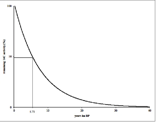
Figure 4.1: Radiocarbon decay curve………...44
Figure 5.1 Location of Braun-Blanquet vegetation sampling quadrats in Dartmoor Vlei and immediate surroundings………...50
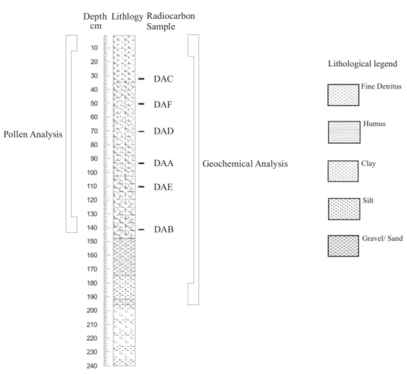
Figure 5.3 Summary of analyses carried out on core DA2………..52
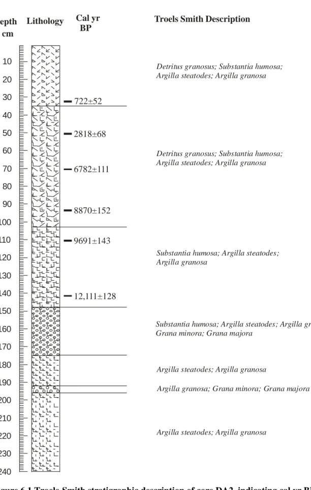
Figure 6.1 Troels Smith stratigraphic description of core DA2, indicating cal yr BP……….61
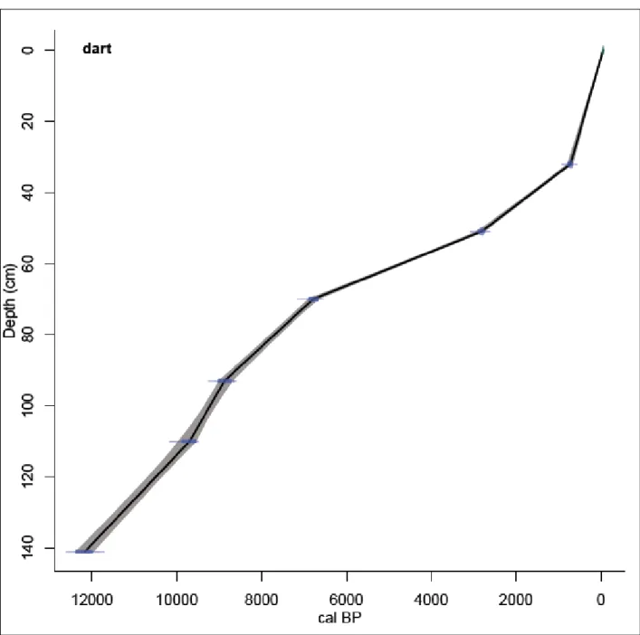
Figure 6.2 Calibrated linear interpolation age-depth model for Dartmoor Vlei ………..…...62
Figure 6.3 Zonation derived from CONISS, based on the regional pollen sum…………..…64
Figure 6.4 Geochemical analysis ………...………..65
Figure 6.5 δ 13C versus C:N relationship ………...…………..66
Figure 6.6 Regional pollen plotted against depth……….…69
Figure 6.7 Grassland and Indigenous forest taxa plotted against depth………...…70
Figure 6.8 Charcoal diagram for Dartmoor Vlei………..73
x
LIST OF TABLES
Table 3.1: Landscape metrics describing indigenous forest patters in the Karkloof-Balgowan region, KwaZulu-Natal, in 1944 and 1996………...27 Table 4.1 Important variables to be considered when sampling peat deposits………36 Table 5.1: Conversion of Braun-Blanquet scale to % cover of individual species…………..48 Table 5.2 Radiocarbon dates………...……….52 Table 6.1 Relative abundance of species recorded at Dartmoor Vlei……….57 Table 6.2 Radiocarbon results for Dartmoor Vlei, indicating calibrated and uncalibrated ages………...59 Table 6.3 Average sediment accumulation rates for Dartmoor Vlei………....63 Table 6.4 Classification of taxa according to regional, local, arboreal and non-arboreal groupings………..68 Table 8.1 Summary of key environmental changes which occurred at Dartmoor Vlei
……….……….85
xi
LIST OF PLATES
Plate 3.1 Dartmoor Vlei, a valley bottom wetland surrounded by hill slopes………..18 Plate 3.2 Dartmoor Vlei, surrounded by Midlands Mistbelt Grassland………...………19 Plate 3.3 Disused artificial drainage channels within Dartmoor Vlei………..21 Plate 5.1 Examples of modern pollen reference slides: (a) Eriocaulon dregei (b) Protea simplex (c) Acacia mearnsii (d) Podocarpus sp.………...48
Plate 5.2 Extraction of a sediment core at Dartmoor Vlei using a Russian peat corer……….51 Plate 6.1 Sediment core DA2 extracted from Dartmoor Vlei………..60
xii
LIST OF ABBREVIATIONS
‰ Parts per million δ 13C Ratio of 12C / 13C
12C Carbon-12 isotope
13C Carbon-13 isotope
14C Radiocarbon δ 15N Ratio of 14N / 15N
14N Nitrogen-14 isotope
15N Nitrogen-15 isotope
AMS Accelerated Mass Spectrometry AP Arboreal Pollen
BP Before Present (starting at 1950)
C3 Calvin-Benson metabolic carbon fixation pathway C4 Hatch-Slack metabolic carbon fixation pathway ca. Approximately
cal Calibrated
CAM Crassulacean acid metabolism CLAM Classic Age Modelling
CONISS Constrained Incremental Sum of Squares
CO2 Carbon dioxide
C/N Carbon:Nitrogen ratio
DA2 Dartmoor Vlei, core number 2 IntCal International Calibration curve
LGM Last Glacial Maximum (23,000-18,000 cal yr BP) m a.s.l. Meters above sea level
NAP Non-arboreal Pollen
SHCal Southern Hemisphere Calibration curve
TN Total Nitrogen
TOC Total Organic Carbon
YD Younger Dryas event (13,000-11,700 cal yr BP) cal yr BP Calibrated year before present
14C yr BP Uncalibrated 14C dates
1 CHAPTER ONE
INTRODUCTION
1.1 INTRODUCTION
South Africa is described by Bamford and Grab (2005:1) as “a treasure trove for those whose mission it is to unlock the mysteries of the past environment”. A key to unlocking these mysteries lies in the understanding of past environmental conditions and the transformations associated with climatic change. Climate change is not a new phenomenon, but rather a continual process that has occurred throughout the history of the earth (Marchant, 2010).
Interest in past climate change has grown considerably and as more palaeo-environmental data are collected, a clearer perspective on shifts in climatic conditions emerge (Zubakov and Borzenkova, 1990; Anderson et al., 2007; Marchant, 2010). Uncertainties surrounding future climate shifts are tangible and justified, on both a global and regional scale (Zubakov and Borzenkova, 1990). Gaining perspective on climate predictions is achieved through: (i) observation of instrumental data collected over the past 100 years; (ii) the use of climate simulation models; and (iii) empirical reconstruction of past climates through hundreds or thousands of years. As information is gathered on past climates, an understanding of past environmental changes can be formulated at both a regional and international scale (Zubakov and Borzenkova, 1990). Thus, palaeo-environmental research has become a spatial and temporal tool for researchers from a multitude of disciplines to explore methods of palaeo- reconstruction through a diversity of proxies.
An array of proxies such as pollen, foraminifera, and diatoms are available to researchers in the field of palaeo-reconstruction (Birks, 1995; Burroughs, 2005; Anderson et al., 2007).
When direct evidence is lacking, proxies are used as a substitute measure of past environmental or climatic conditions (Anderson et al., 2007). Depending on the location of the study site and the expected outcome of the research, a set of proxies can be selected to achieve the aim of the study. Palynology (pollen analysis) is one such technique available to palaeo-researchers, which provides a quantitative record of historical climate changes, and an effective tool for the reconstruction of vegetation transformation and response to shifting climatic conditions (Ortu et al., 2006).
2 Palynology has become one of the most widely-used tools in vegetation reconstruction for long-term periods (Bunting, 2008). The primary aim is to study the morphology of modern and fossil pollen and spores, although the technique is applied in various fields of study:
botany, archaeology, climatology and geology, and the interest in this tool has grown and evolved considerably (Traverse, 1999). The nature of pollen grains is such that they are easily dispersed and preserved due to their size and decay-resistant sporopollenin outer wall, respectively. Under anaerobic conditions, pollen grains may be preserved for hundreds or thousands of years, allowing for extraction, processing and interpretation of pollen signals in a sediment core (Bunting, 2008). Through the use of multi-proxy analyses, independent lines of evidence can be used to formulate an understanding of past environmental and climatic conditions (Eeley et al., 1999; Duffin, 2008; Castãneda et al., 2009).
Understanding natural variability and responses to environmental change, and how people and ecosystems have responded and adapted to change is vital (Marchant, 2010). Human activity has resulted in the transformation of ecosystems and the distribution of the earth‟s vegetation to varying degrees across the globe. However, the respective importance of humans and environmental factors is controversial when interpreting the distribution of vegetation patterns in the montane regions of Africa (Meadows and Linder, 1993). Some argue that current afro-montane grasslands exist as a result of recent anthropogenic forest clearing, while others contend that these grasslands have historically been a component of montane vegetation (Meadows and Linder, 1993).
Long-term history in southern Africa has shown changes in vegetation due to anthropogenic activities such as burning and vegetation clearing, even in the most remote regions of the continent. Chapman and White (1970) suggest that Afromontane grasslands originated, and expanded, due to anthropogenic impacts. These changes in vegetation, for example clearance of forests and increase in grasslands, have been attributed to the role and impacts of humans in the environment (Chapman and White, 1970; Meadows and Linder, 1993). Bredenkamp et al. (2002) attributes the distribution of grasslands to climatic changes during the Oligocene, and suggests that the current distribution of grasslands in southern Africa does not differ greatly in extent to the Holocene. Anthropogenic impacts such as agriculture and forest clearing did not affect the historical distribution of current grasslands, at least not until the
3 late Holocene (Bredenkamp, 2002). The nature and extent of these changes are worthy of research to appropriately manage these environments (Hamilton, 1981; Meadows et al., 1987). An understanding of such environmental history, particularly in a region with such high diversity of flora and fauna, would be valuable in formulating conservation and management policies (Hamilton, 1981), particularly in regions such as the KwaZulu-Natal Midlands where a complex mosaic exists between the Midlands Mistbelt Grassland, the Karkloof forest, and human inhabitants.
In South Africa, information related to environmental changes has been constrained by a lack of researchers and funding and environmental limitations in terms of recovery of palaeo- environmental data (Chase and Meadows, 2007). Lake and peat sediments provide natural archives which are most likely to provide suitable pollen samples for analysis and inference of past conditions (Anderson et al., 2006), however South Africa is predominantly an arid region, and therefore environmental conditions are seldom suitable for pollen preservation (Coetzee and van Zinderen Bakker, 1970; Nyakale and Scott, 2002). While southern African palaeo-records require extensive investigation, various studies conducted across the region have provided a growing collection of palaeo-ecological data. However, the KwaZulu-Natal Midlands region remains an area where minimal palaeo-ecological data are available.
Although no empirical evidence exists to support the notion, Everard (1985) suggests that Podocarpus forest patches in the Natal Drakensberg were more extensive in the past. Due to changing environmental conditions and increase in fire frequency due to human intervention, the forest patches have significantly reduced and grasslands have expanded (Meadows and Linder, 1993). In the KwaZulu-Natal Midlands (Eeley et al., 1999), the Midlands Mistbelt grasslands and forest are similarly under threat of degradation, highlighting the need for more research of historical change to be carried out in the region.
Dartmoor Vlei is a high altitude wetland situated near Mt. Gilboa in the KwaZulu-Natal Midlands, South Africa, and has potential to address the knowledge gap of palaeo- environmenmental history of the KwaZulu-Natal Midlands region. The area falls within a summer rainfall region (Begg, 1989), and the wetland is characterised by permanently waterlogged conditions and peat deposits (Edwards, 2009). The KwaZulu-Natal Midlands are characterised by a mosaic of Southern Mistbelt Forests and Midlands Mistbelt Grasslands
4 (Mucina and Rutherford, 2006), two vegetation units which are considered vulnerable (Scott- Shaw, 1999). Unaltered natural grassland surrounds the wetland, although commercial forestry plantations and annual crops are grown in the surrounds, and one of the largest indigenous forests remnants in KwaZulu-Natal, the Karkloof forest, is situated nearby (Rycroft, 1994), rendering Dartmoor Vlei an ideal site for grassland and forest investigation through palaeo-environmental research.
Across southern Africa, further analytical research is required to further our understanding of past environmental conditions (Scott, 1993). With the possibility of major environmental and climatic changes predicted for the near future, an understanding of the effect of past climatic conditions will provide a benchmark understanding of natural variability (Scott, 1993;
Anderson et al., 2006) and assist in formulating long-term management strategies for vulnerable natural resources (Willis and Birks, 2006; Watrin et al., 2007; Bunting, 2008).
The research presented in this thesis aims to provide just such an understanding of Holocene environmental conditions of the KwaZulu-Natal Midlands, using a sediment core extracted from Dartmoor Vlei.
1.2 AIM AND OBJECTIVES
To investigate Holocene palaeo-environmental change in the KwaZulu-Natal Midlands by applying multi-proxy analyses, viz. fossil pollen, charcoal, carbon and nitrogen isotope analyses, to a sedimentary record from Dartmoor Vlei, Mt. Gilboa. This will be achieved through the following objectives:
(i) To survey, map and develop an inventory of the modern vegetation of the wetland and immediate surrounds;
(ii) To develop a local modern pollen reference collection, as an aid to fossil pollen identification;
(iii) To identify suitable coring locations and extract a series of minimally disturbed sediment cores from the wetland;
5 (iv) To select samples from basal and intermediate sections of a selected core for AMS radiocarbon analysis to establish chronological control for the core; and create an age-depth model;
(v) To identify and quantify fossil pollen along the length of the core to detect local and regional vegetation changes;
(vi) To conduct geochemical (C and N isotope) analyses along the length of the core to detect changes in the relative proportion of C3 and C4, and aquatic and land plants inhabiting the wetland site;
(vii) To reconstruct past Holocene environmental history of the KwaZulu-Natal Midlands.
1.3 THESIS OUTLINE
The aim of the introduction chapter is to familiarise the reader with the purpose, and importance of the research undertaken in the palaeo-environmental field. This chapter presents an outline of the aim and objectives of the research, and research approaches adopted in the study. A review of South African palaeo-environmental history is summarised in Chapter Two. To provide details of Dartmoor Vlei and insight into the background and surroundings of the Mt Gilboa region, an overview of the Karkloof forest and Midlands Mistbelt grasslands are provided in Chapter Three. Chapter Four provides a theoretical background to the methodologies adopted in the field of palaeo-research, and describes the methods used in pollen, charcoal, geochemical and radiocarbon analysis. Chapter Five describes the research methods, and Chapter Six depicts and describes the results. Chapter Seven provides a discussion and reconstruction of the palaeo-environmental conditions of the Mt. Gilboa region, as inferred from the results of the multi-proxy analysis conducted. In conclusion, the final chapter provides a synthesis of the palaeo-environmental changes at Mt Gilboa, KwaZulu-Natal Midlands.
6 CHAPTER TWO
REVIEW OF SOUTH AFRICAN PALAEO-ENVIRONMENTAL HISTORY
2.1 DRIVERS OF CLIMATE CHANGE
An understanding of drivers of climate change is valuable in interpreting historical climatic changes, as inherent curiosity not only leads us to question the extent of changes which occurred, but also the reasons behind such change. During the time which humans have inhabited the earth, there have been numerous environmental changes taking place at variable intensities (Anderson et al., 2007) and timescales (Nash and Meadows, 2012), such as:
climatic changes; sea level change; shifts in vegetation belts; animal populations; and soils and landforms (Anderson et al., 2007). The causes of climate change have been hypothesised, although criticisms surrounding many major hypotheses remain. The main hypotheses relate to solar radiation; atmospheric transparency; the earth‟s geometry (orbital forcing, Milankovitch Cycles); changes in terrestrial geography; greenhouse gases and the feedback hypothesis. Detailed reviews of the drivers of climate change are provided by Goudie (1992), Burroughs (2005), Anderson et al. (2007) and Nash and Meadows (2012), and will be briefly discussed.
The theory of astronomical fluctuations was first introduced by Adhemar in 1842, and further developed by Croll and Milankovitch in the 1860s and 1920s respectively. The Croll- Milankovitch Cycle, or orbital forcing, is based on the notion that if the location and arrangement of the earth in relation to the sun was to change, then so might insolation from the sun. Three factors occurring at various timeframes have been identified to explain the occurrence of such change: a change in the eccentricity of the earth‟s orbital path (100,000 year cycle); the precession of the equinoxes (19-23,000 year cycle); and obliquity (41,000 year cycle), changes in the angle between the plane of the earth‟s orbit and the plane of its rotational equator (Goudie, 1992; Ruddiman, 2003; Anderson et al., 2007; Nash and Meadows, 2012). Glacial periods are interrupted by interglacial periods when these three factors combine to maximise solar energy received during summer in the northern hemisphere, resulting in winter-snow melting. Similarly, when orbital parameters are such as the amount of solar energy is reduced, summer in the northern hemisphere is cooler resulting in less snow melting, thus allowing glaciers to expand (Goudie, 1992; Anderson et al., 2007).
7 Climatic cycles have been greatly influenced by changes in solar radiation output, which changes in both quantity (as a result of phenomenon such as sunspots) and quality (changes in the ultraviolet range of the solar spectrum). Although criticised, the role of solar activity has been correlated with major characteristics of general atmospheric circulation (Goudie, 1992; Anderson et al., 2007).
The effect of incoming solar radiation may be lessened by changes in atmospheric composition, for example volcanic dust, as backscattering is increased. Volcanic dust in the atmosphere may promote the formation of ice-crystals where atmospheric conditions are below freezing and air is saturated, and the presence of sulphur dioxide may result in acid droplets forming, thus reducing insolation. These factors are responsible for reduced atmospheric temperatures as less solar radiation is able to reach the earth‟s surface (Goudie, 1992; Anderson et al., 2007). Although large volcanic activity is not a regular occurrence, the cooler climate of the Little Ice Age which followed the Medieval Warm Period, has been linked to volcanic activity between 600 and 1300 AD, and 1400 and 1985 AD (Anderson et al., 2007) and cold, wet summers in Britain can be attributed to high volcanic dust concentrations in the atmosphere in (inter alia) 1695, 1725, 1816, 1879, 1903 and 1912 (Goudie, 1992; Anderson et al., 2007). Further sources of high levels of dust in the atmosphere may be a result of elevated wind activity increasing surface material emplaced in the atmosphere, or from an influx of dust from outer space (Anderson et al., 2007).
Although change in terrestrial geography would be considered long-term change, changes in the polar axis, and shifts in the position and uplift of continents, may be responsible for climatic changes in some parts of the world (Goudie, 1992; Anderson et al., 2007).
Considering extensive time periods, it may be possible that over thousands of years continental uplift will increase altitudes by several meters. As a result, marked temperature decrease at the summit and change in precipitation may be experienced (Goudie, 1992;
Anderson et al., 2007).
Ocean circulation can also be a driver of climate change, and may be due to natural or anthropogenic impacts. The Gulf Stream and the North Atlantic Drift currents are responsible for carrying warm, saline surface water from the oceans of the Gulf of Mexico to
8 Greenland, Iceland and Norway. As these waters move northwards, they cool, and sink due to an increase in density. This „pull‟ action maintains the movement of the warm Gulf Stream, and is responsible for keeping winters in the British Isles milder than expected at such latitudes (Goudie, 1992; Burroughs, 2005; Anderson et al., 2007). However, studies have shown that if an increase in freshwater were to occur (e.g. due to melting icecaps or from fresh water inland lakes) in the Arctic Sea, the deep-water production of the North Atlantic would cease. As the „Atlantic Conveyor‟ system is disrupted by the dilution of this dense, saline ocean water, icecaps may form and prevent the circulation of the Gulf Stream (Goudie, 1992; Burroughs, 2005; Anderson et al., 2007).
Atmospheric carbon dioxide (CO2) levels have an effect on the global heat balance, as CO2
does not impact on isolation but absorbs outgoing terrestrial radiation (Goudie, 1992;
Anderson et al., 2007; Nash and Meadows, 2012). As a result, heat cannot escape the atmosphere into space, causing temperatures to rise, a phenomenon known as the greenhouse- effect. Similarly, low levels of global CO2 leads to climatic cooling, as indicated by analyses of CO2 concentrations in bubbles trapped in ice cores (Goudie, 1992; Anderson et al., 2007).
Such analysis has shown a definitive correlation between climatic change and CO2
concentrations in the atmosphere over the last 16 000 years, where glacial periods indicate low CO2 levels and interglacial periods indicate high CO2 levels (Goudie, 1992; Anderson et al., 2007). Greenhouse gas concentrations are enhanced by anthropogenic activities, and it has been hypothesised that humans began altering greenhouse gas concentrations in the late- Holocene through agricultural practices (Vavrus et al., 2008).
Minor environmental changes in landmasses, oceans, the atmosphere and ice may have a dramatic effect on climatic shifts (Goudie, 1992; Anderson et al., 2007). Termed the
„feedback‟ hypothesis, it is suggested that these processes produce a larger or lesser climatic response than would have arisen without their involvement (Williams et al., 1998). Factors such as albedo controls the extent to which insolation is reflected or absorbed, depending on conditions on the earth‟s surface, for example, dark volcanic ash will absorb insolation, whereas icecaps will reflect insolation. If such conditions persist over an extended period of time, it may result in regional or global climatic shifts (Goudie, 1992; Williams et al., 1998;
Anderson et al., 2007).
9 Almost all changes in climate can be explained through natural variability in the global weather system, both on short timescales and over millennia. Occasionally, various components of climate systems may interact to produce major fluctuations (Burroughs, 2005). There has been hypothesised that current global warming as a result of anthropogenic activities may “push the climate into a more erratic mode” (Burroughs, 2005: 69), as an increase in average global temperatures since the mid-20th century can most likely be attributed to increased anthropogenic greenhouse gas concentrations (IPCC, 2007).
Understanding the nature of past and present environmental change and drivers of climate change is vital in forming an understanding of challenges relating to climate change (Williams et al., 1998; Burroughs, 2005). Holocene environmental research provides a unique historical perspective essential to long-term management (Williams et al., 1998).
2.2 THE HOLOCENE IN SOUTH AFRICA
Historically, southern Africa lacked detailed data which could be used for palaeo- environmental reconstruction and a need for suitable deposits and pollen sequences hindered advancement in vegetation reconstruction for the region (Scott, 1984; Avery, 1993;
Meadows, 2001). However, in recent years, palaeo-environmental research has progressed with researchers in various disciplines producing a growing number of datasets (Avery, 1993) through the use of alternate methods in palaeo-reconstruction, such as hyrax-middens, dendrochronology and speleothems (Goudie, 1992; Burroughs, 2005). With a growing body of knowledge and methods, it is important to establish a basis for comparison of various sites.
For example, at Cold Air Cave in the Makapansgat Valley, a ca. 25,000 year old high resolution stalagmite record with excellent chronological control (particularly during the Holocene) has provided a basis for comparison of records for southern Africa (Holmgren et al., 2003).
The transition from the glacial conditions of the Pleistocene to the warmer conditions of the Holocene is described by Abell and Plug (2000: 1) as “far from smooth”, and the climatic changes within the Holocene period do not differ greatly from this description. The Holocene is a time period during which many cultural and environmental changes had taken place (Roberts, 1998), and is generally understood to cover the last 11,500 years (Chase and Meadows, 2007). The Holocene can be divided into two broad time periods: the early
10 Holocene (ca. 11,700 to ca. 6000 cal yr BP) and late-Holocene (ca. 6000 cal yr BP to present). Holocene records suggest that climatic conditions in South Africa show a considerable variation between ca. 13,600 and 6100 cal yr BP (11,850 and 5400 14C yr BP;
Scott et al., 2005). The warmest period in the Holocene is represented by the Holocene Altithermal, broadly accepted to be approximately 8000 – 4000 cal yr BP although regional variability does occur (Chase and Meadows, 2007). Biological evidence indicates that the eastern region of South Africa experienced maximum warming between ca. 8800 and 5700 cal yr BP (8000 and 5000 14C yr BP; Partridge et al., 1990), which is concordant with the Holocene Altithermal. A summary of the comparisons from multiple sites drawn from Holmgren et al. (2003) is provided. Due to the location of Dartmoor Vlei in the KwaZulu- Natal Midlands region, emphasis is placed on records from the summer rainfall region of South Africa.
At ca. 23,000 – 21,000, 19,500 – 17,500 and 15,000 – 13,500 230Th/234U yr BP (calendar years before 2000 AD), δ18O records indicate conditions were drier, temperatures lower and grass cover reduce in South Africa (Holmgren et al., 2003). Records from Cold Air Cave (speleothem δ 18O) and Wonderkrater (pollen-derived) show a period of rapid warming after a cold event at 17,500 230Th/234UBP (before 2000 AD), cooling again at 15,000 230Th/234U yr BP and warming at 13,500 230Th/234U yr BP (before 2000 AD). A period of maximum cooling occurred at 17,500 230Th/234U yr BP, indicating cool, dry conditions at this time (Holmgren et al., 2003). The Wonderkrater pollen record indicates evaporative conditions, although not necessarily low rainfall, between 12,000 and 10,000 230Th/234U yr BP (before 2000 AD), and both Cold Air Cave and Wonderkrater records indicate warm conditions between 10,000 and 6000 230Th/234U yr BP (before 2000 AD). This period of warming precedes the generally acknowledged Holocene Altithermal timing in southern Africa by ca.
2000 230Th/234U yr BP. At 9000 – 8400 230Th/234U yr BP, δ 13C records at Cold Air Cave reaches its lowest point, indicating an abundance of C3 woody vegetation and a sharp reduction in C4 grass cover. After 8500 230Th/234U yr BP, the Cold Air Cave record indicates an increase in grass cover, while conditions at Wonderkrater suggest dry, grassy vegetation (Holmgren et al., 2003). A cool period is recorded at Cold Air Cave and Wonderkrater between 6000 and 3000 230Th/234U yr BP, when conditions were predominantly dry, followed by cool, grassy environments between 3000 and 2000 230Th/234U yr BP and warm wet conditions between 1200 and 600 14C yr BP (Holmgren et al., 2003).
11 The Wonderkrater pollen record provides evidence of increasing temperatures at ca.15,500 cal yr BP (13,000 yr BP; Scott et al., 2003), however an increase in Podocarpus forests during the same period is interpreted as an indication of moist, cool conditions at Mfabeni (Finch and Hill, 2008). The Cathedral Peak pollen record indicates regionally cool, dry conditions at 15,490 cal yr BP, as indicated by the presence of Amaranthaceae, Ericaceae and Tubiliflorae. Dominance of local pollen taxa in the record suggests that wetland vegetation was supported (Lodder, 2010). An increase in Amaranthaceae and Chenopodiaceae at Wonderkrater at ca. 14,900 cal yr BP (12,700 14C yr BP) suggests slightly cooler but evaporative conditions, although Scott et al. (2003) indicate drier conditions at the site at the Pleistocene/Holocene boundary.
Figure 2.1 Selected palynological sites in the summer rainfall region, South Africa
(Cathedral Peak: CP; Cold Air Cave: CA; Dartmoor Vlei: DA; Lake Eteza: LE; Lake Sibaya: LS; Mfabeni: MF; Mafayeni:
MF; Malahlapanga: ML; Mgobezeleni: MG; Muzi-Oos: MO; Nhlangu: NH; Rietvlei Dam: RI; Soutpansberg: SO; Tswaing:
TS; Winterberg: WI; Wonderkrater: WK; Wonderwerk: WW). *Rainfall regions adapted from Finch et al., 2003
12 During the early Holocene there is a period of warm, dry climatic conditions (Scott, 1990;
Partridge et al., 1990), with more mesic types of woodland than evident during the late Pleistocene (Scott, 1982b) resulting in expansion of warm, semi-arid savannah. This is supported by evidence from the Soutpansberg, which records an increase in savanna vegetation at ca. 12,800 cal yr BP (11,000 14C yr BP; Scott, 1987). Meadows et al. (1987) indicate that although no marked changes occur in the Winterberg, cooler and possibly drier conditions prevail from ca. 14,600 cal yr BP (12,500 14C yr BP) into the early Holocene.
Grundling et al. (1998) conducted preliminary palynological investigations of major pollen taxa at Mfabeni (east-coast of South Africa), although the main focus of the work was relating to peat accumulation rates. The pollen record from Mfabeni peatland shows an expansion in hydromorphous forest, as indicated by an increase in Podocarpus, Olea, Syzigium, Myrica and Celtis at ca. 13,400 cal yr BP (11,570 14C yr BP). Contrasting records from Rietvlei Dam from 11,490 - 7730 cal yr BP indicate low arboreal and local pollen concentrations, indicating grasslands dominated the period under cool, temperate, dry, sub- humid conditions (Scott and Vogel, 1983). These conditions are supported at Wonderkrater where arboreal pollen (including Podocarpus) decreases, indicating a reduction in arboreal vegetation (Scott, 1982c). At Lake Eteza (east-coast of South Africa), arboreal pollen frequencies decrease in the region at ca. 10,500 cal yr BP (Neumann et al., 2010). A period of noticeable warming is recorded in the Winterberg at ca. 10,000 cal yr BP (Scott et al., 1995) and observed at Wonderkrater 700 years later, where a reduction in swamp vegetation and Podocarpus were observed (Scott, 1982c).
After ca. 10,700 cal yr BP (9500 14C yr BP), warmer conditions are indicated at Wonderkrater as proportions of Asteraceae and Combretaceae increase after ca. 10,700 cal yr BP (9500 14C yr BP), and Poaceae rapidly increases at ca. 9500 cal yr BP (8500 14C yr BP).
(Scott and Vogel, 1978). However, Partridge et al. (1990) report a brief period of cooling between ca. 10,100 and 8800 cal yr BP (9000 and 8000 14C yr BP) at Lake Eteza. Tswaing (Gauteng) records indicate similar dry, moderately warm conditions at ca. 8800 cal yr BP (8000 14C yr BP), however this is followed by warm but wetter conditions at about ca. 7800 cal yr BP (7000 14C yr BP; Partridge et al., 1993). Similarly, conditions at Winterberg remained dry until 8000 cal yr BP, as indicated by Asteraceae, Chenopodiaceae and Thymelaeaceae, however an increase in wetter conditions is indicated by Cyperaceae, an
13 indicator of more water-logged conditions (Meadows and Meadows, 1988). After 8000 cal yr BP, low concentrations of montane forest taxa appeared, and taxa associated with drier conditions decreased in the Winterberg pollen record, an indication of more moist conditions (Meadows and Meadows, 1988), followed by warmer conditions in the Transvaal Highveld after 7400 cal yr BP (Scott and Vogel, 1983). Records from Wonderkrater indicate a similar trend (Scott, 1982c).
Wetter conditions at Lake Eteza are indicated by high percentages of arboreal pollen and fern spores, and a higher water table is inferred until ca. 8500 cal yr BP. Poaceae frequencies increase at Lake Eteza between ca. 8000 and 7000 cal yr BP indicating grassy conditions, followed by a decrease at ca. 6800 cal yr BP (Neumann et al., 2010). Similar conditions are experienced at Mfabeni, where an initial increase in grassland in the early Holocene is followed by the reestablishment of Podocarpus-abundant forests after ca. 8300 cal yr BP (7500 14C yr BP; Finch and Hill, 2008). An increase in abundance and diversity of arboreal pollen taxa is recorded between ca. 8300 and 6800 cal yr BP (7500 and 6000 14C yr BP) followed by a sharp decrease in arboreal pollen after ca. 6800 cal yr BP (6000 14C yr BP).
Cyperaceae decrease at this time, indicating local drying at Mfabeni (Finch and Hill, 2008).
The pollen record from Lake Sibaya (Neumann et al., 2008) is concordant with Mfabeni, with a high percentage of forest pollen taxa and relatively low Poaceae and herb percentages during the mid-Holocene.
Records from the former Transvaal show a similar period of increasing temperatures during the mid-Holocene between ca. 7800 and 6800 cal yr BP (7000 and 6000 14C yr BP; Scott, 1990). The Wonderkrater pollen record provides evidence of warm, dry climatic conditions during the early Holocene, and wet and warm conditions during the mid-Holocene, which corresponds with records from sites in the former Transvaal (Scott, 1990).
Although mid-Holocene generally indicates warm, wet conditions, the late Holocene is characterised by cooler conditions (Scott, 1990) where semi-arid savannah is replaced by more broad-leafed woodland in the Transvaal (Scott, 1983). The Soutpansberg record, however, indicates that minimal environmental change has occurred since the mid-Holocene (Scott, 1982d). The Wonderkrater record indicates broad-leaf bushveld vegetation at ca.
14 6800 cal yr BP (6000 14C yr BP) which is associated with wetter conditions (Scott, 1982c), followed by a cooling trend from ca. 6800 cal yr BP (6000 14C yr BP) to the present (Scott et al., 2003). The Lake Eteza pollen record shows a decrease in Poaceae percentages and an increase in arboreal pollen taxa at ca. 6500 cal yr BP (Neumann et al., 2010). At 6500-6300 cal yr BP, Rosaceae and Podocarpus signals occur in high concentrations at Cathedral Peak, a possible indication of moist conditions. At 6200 cal yr BP, Rosaceae and Podocarpus signals are absent from the Cathedral Peak record, in spite of expectation that moist conditions are generally suited to montane forest expansion (Lodder, 2010). Locally, conditions at Cathedral Peak suggest that moisture levels decreased, thus becoming slightly drier between 6200 and 5760 cal yr BP (Lodder, 2010).
Mazus (1996) found that the record from Nhlangu (east-coast of South Africa) shows hydromorphous forests dominated by Myrica and Syzygium, followed by an increase in Podocarpus pollen and then a retreat in forest components from ca. 5800 cal yr BP (5100 14C yr BP). Similar trends are found by Grundling et al. (1998) at Mfabeni in the mid-Holocene.
After ca. 6300 cal yr BP (5600 14C yr BP), an expansion on forests is recorded at Mfabeni as arboreal pollen increases (Finch and Hill, 2008), a trend paralleled by the Lake Eteza record (Neumann et al., 2010) which indicates a peak in forest taxa at ca. 5500 cal yr BP. At 5700 cal yr BP, Gillson and Ekblom (2009) suggest that vegetation at Malahlapanga (Kruger National Park) was dominated by open grassland, where fire was rare or absent.
Arboreal pollen further increases at ca. 4500 14C yr BP, and with continuing cool, wet conditions at ca. 4400 cal yr BP (4000 14C yr BP) at Mfabeni (Finch and Hill, 2008).
Conditions at Wonderwerk become cooler and wetter at ca. 4400 cal yr BP (4000 14C yr BP;
Scott 1982c). Wonderkrater and Tswaing records suggest low temperatures and dry conditions at ca. 3100 cal yr BP (3000 14C yr BP; Scott et al., 2003 and Scott 1990). The decrease in Podocarpus pollen at Muzi-Oos at ca. 4700 cal yr BP (4200 14C yr BP; Grundling et al., 1998) and at Lake Eteza after ca. 5600 cal yr BP (3400 14C yr BP; Scott and Steenkamp, 1996) indicates a tendency towards drier conditions. Cooler, more temperate conditions are experienced at Wonderkrater between 4030 - 2090 cal yr BP, as indicated by the decrease in arboreal pollen in the record (Scott, 1982c).
15 At Lake Eteza, Podocarpus percentages reaches a maximum of >30% at 3700 cal yr BP, signalling moist subtropical conditions, although a rapid drop to approximately 8% is recorded at ca. 3500 cal yr BP. The decline in Podocarpus is accompanied by a decline in other forest elements (Neumann et al., 2010). A decrease in forests at Mfabeni is recorded after ca. 3700 cal yr BP (3500 14C yr BP; Finch and Hill, 2008), supported by records from Mfabeni by Grundling et al. (1998), from Nhlangu by Mazus (1996) and from Lake Eteza by Scott and Steenkamp (1996). Podocarpus concentrations peak at 3960 cal yr BP at Cathedral Peak, an indication of moist conditions (Lodder, 2010). The Transvaal shows slightly lower temperatures at ca. 3100 cal yr BP (3000 14C yr BP; Scott, 1990). The Lake Eteza record indicates high percentages of Poaceae and Asteraceae, and low percentages of arboreal taxa, representing a relatively dry grassy environment between ca. 3600 and 2000 cal yr BP (Neumann et al., 2010).
At ca. 1900 cal yr BP (2000 yr BP) conditions become warmer and drier (Scott and Vogel, 1978 and Scott, 1982c), and ca. 1300 cal yr BP (1500 14C yr BP) record at Soutpansberg indicate a sharp decline in arboreal pollen taxa (Scott, 1987). The Wonderkrater record indicates that the modern climate of the Transvaal bushveld originated at ca. 1900 cal yr BP (2000 14C yr BP; Scott, 1982c). The Lake Eteza record indicates a relative increase in arboreal pollen taxa at ca. 2000 cal yr BP (Neumann et al., 2010). The Rietvlei record suggest a decrease in arboreal pollen taxa and Cyperaceae while there was an increase in Amaranthaceae, Asteraceae and Chenopodiaceae from 2240 cal yr BP onwards, indicating a shift towards grassland vegetation with cooler, moist, sub-humid temperatures (Scott and Vogel, 1983). However, at Wonderkrater, the occurrence of arboreal pollen taxa increases, indicating warmer conditions tending towards bushveld vegetation (Scott, 1982c).
The pollen record at Mafayeni (Kruger National Park) indicates a resilient savannah phase throughout the past ca. 1200 cal yr BP (1300 14C yr BP), where no major phase changes are observed (Gillson and Ekblom, 2009), and attributed to water, fire and herbivory which limits tree density. At Malahlapanga (Gillson and Ekblom, 2009), a transition from open grassland to savannah occurs at the end of the 9th century A.D. (ca. 1100 cal yr BP). A relative increase in Cyperaceae, indicating wetter conditions, is recorded at Nhlangu after ca. 1300 cal yr BP (1390 14C yr BP; Mazus, 1996) and an increase in swamp forest vegetation at Mgobezeleni is recorded after ca. 1200 cal yr BP (1300 14C yr BP). The Mfabeni record (Grundling et al.,
16 1998) suggests the establishment of swamp forests dominated by Syzigium, Myrica and Ficus after ca. 570 cal yr BP (600 14C yr BP). The Mfabeni record indicates a dominance of Poaceae, and low frequencies of arboreal taxa and Cyperaceae from ca. 860 cal yr BP (1000
14C yr BP) to present. The pollen record indicates similar warm, dry, savannah-like conditions as experienced at present at Mfabeni (Finch and Hill, 2008). δ18O records from Cold Air Cave reflects humid conditions at ca. 690 cal yr BP (800 14C yr BP) followed by drier, cooler conditions after ca. 570 cal yr BP (600 14C yr BP; Repinski et al., 1999). At Winterberg, anthropogenic influences are suggested in the last 890 cal yr BP, indicated by a decrease in arboreal pollen taxa, and a relative increase in disturbance indicators such as Anthospermum, Ericaceae, Mimosoides and Stoebe. Exotic Pinus, indicative of timber plantations at Winterberg, are recorded in the last 150 years (Meadows and Meadows, 1988).
Between 1900 and 860 cal yr BP (2000 and 1000 14C yr BP) the eastern region of South Africa indicates wetter conditions than experienced at present (Partridge et al., 1990).
Cool, moist conditions are inferred from the pollen record at Cathedral Peak until 1680 cal yr BP, after which conditions become moister and warmer. This is seen from the decrease of Ericaceae in the pollen record, and Podocarpus concentrations increase after 1200 cal yr BP, further supporting the notion of warmer, moist conditions (Lodder, 2010). Podocarpus concentrations at Cathedral Peak increase dramatically at about 1100 cal yr BP, suggesting that montane forests were expanding. Leucosidea and Cordia, present between 1880-1760 cal yr BP, suggest that forests occurred within the wetland region, surrounded by grassland (Lodder, 2010). Conditions at Cathedral Peak shift from slightly drier to slightly wetter at ca.
1000 cal yr BP, supported by evidence from the pollen records (Lodder, 2010). At Lake Sibaya, a decrease in Podocarpus pollen concentrations at ca. 1500 - 1250 cal yr BP is followed by an increase in cereal-type Poaceae, indicating human presence in the region (Neumann et al., 2008). The Cathedral Peak pollen record indicates the appearance of Pinus and cereal-type Poaceae, an indication of human presence. Cereal-type Poaceae occurs from the first time at about 890 cal yr BP, and again in modern samples. Pinus appears at about 105 cal yr BP, although Pinus was first planted in Cathedral Peak in 1950 (Lodder, 2010).
This discrepancy may be due to issues related to the chronology of the core. The Lake Eteza record indicates dramatic changes in the vegetation from ca. 700 cal yr BP. There is a sharp decline in arboreal and shrub taxa, and a relative increase in Poaceae to about 85%, indicating a shift towards drier conditions and a retreat in forest elements (Neumann et al., 2010).
17 These changes may be attributed to pastoralism and crop cultivation, as Iron Age farming activities in the eastern parts of South Africa began at ca. 1400 cal yr BP (1600 14C yr BP;
Neumann et al., 2010).
2.3 CONCLUSION
This chapter provides an understanding of the drivers of climate change, and summarised trends of environmental change which occurred at numerous sites during the Holocene in South Africa. The need for comparison between sites is essential in palaeo-environmental research, as a regional picture of environmental change emerges. Site specific responses are of significance, however where areas lack research, comparison of regional change becomes problematic. Ensuring research is conducted at a high resolution and obtaining solid chronological control, is vital to creating a broader understanding of environmental change.
Although trends such as the Holocene Altithermal emerge from comparison of various sites, further palaeo-environmental research is key to producing reliable regional trends and fill in gaps in our understanding of specific regions such as Mt Gilboa, where a mosaic of grasslands and forests exist.
18 CHAPTER THREE
SITE DESCRIPTION
3.1 INTRODUCTION
The following chapter introduces the research site and surrounding environment, including details of geology, drainage and land use. The indigenous forest and grassland biomes of South Africa are discussed, with a focus on the patch-mosaic assemblage of the Karkloof Forest and Midlands Mistbelt Grasslands. Furthermore, a historical overview of human occupation in the Karkloof Catchment, and their land-use practices is provided.
Plate 3.1 Dartmoor Vlei, a valley bottom wetland surrounded by hill slopes
19 3.2 LOCALITY
KwaZulu-Natal is a province primarily covered by grasslands, savannah woodlands, bush thickets and forests (Fairbanks and Benn, 2000). The Midlands region of KwaZulu-Natal in particular is characterised by a mosaic of Southern Mistbelt Forests and Midlands Mistbelt Grasslands (Mucina and Rutherford, 2006), of which a prominent area is the Karkloof forest.
Dartmoor Vlei is a valley-bottom wetland (Edwards, 2009) situated at Mount Gilboa in the KwaZulu-Natal Midlands, South Africa, (29.2857°S; 30.2559°E; Figure 3.1). This 42 ha wetland is located at an altitude of 1563 m, on the headwaters of the Myamvubu River, a tributary of the Mooi River (Edwards, 2009). The area falls within a summer rainfall region, where the catchment receives an average annual rainfall of 1000 mm (Moll, 1978; Begg, 1989), occasional snowfalls, and heavy frost (Begg, 1989). Dartmoor Vlei is characterised by an array of small, discontinuous meandering channels, a lack of classic floodplain features (e.g. backswamps, alluvial ridges, oxbow lakes and levees), predominantly diffuse flow and permanently waterlogged conditions, and organic rich deposits (Edwards, 2009).
Plate 3.2 Dartmoor Vlei, surrounded by Midlands Mistbelt Grassland
20 Figure 3.1 Location of Dartmoor Vlei, Mt Gilboa, KwaZulu-Natal in South Africa.
Position of sediment cores (DA1; DA2) extracted from Dartmoor Vlei. (A: Western Cape;
B:Northern Cape; C: Eastern Cape: D: KwaZulu-Natal; E: Lesotho; F: Freestate; G: North West; H: Gauteng; I:
Limpopo; J: Mpumalanga; K:Swaziland)
3.2.1 Geology
The Karkloof Plateau is underlain by shale, siltstone and sandstone which have been intruded by Jurassic dolerite sills and dykes. Although the dolerite dykes are highly resistant and show little sign of weathering, the dolorite sill capping the plateau has been subject to chemical weathering, resulting in some lower lying valley bottom basins (including Dartmoor Vlei) comprising of residual saprolite in excess of 7 m in depth (Begg, 1989; Edwards, 2009).
21 3.2.2 Drainage
Dartmoor Vlei is located within a gently sloping valley (Figure 3.2) which terminates against a dolerite dyke at the toe of the wetland. The wetland is surrounded by dolerite ridge outcrops which extend upwards from broad terrestrial planation surfaces (flat areas created by fluvial action) (Edwards, 2009). Two mountain streams enter the wetland at the southern boundary and are diverted into artificial channels that were excavated throughout the length of the wetland.
The wetland has been impacted on by artificial drainage channels (Figure 3.1; Plate 3.3) which were put in place several decades ago to improve drainage for agricultural use (Kotze et al, 2009). In 2004, rehabilitation interventions were carried out on behalf of Working for Wetlands to improve the general health of the wetland. Interventions included: plugging the drainage channels, raising the water table by reducing water-loss from the wetland, and dispersal of water flow across the wetland (Kotze et al, 2009). These measures were in the form of nine weirs placed on the artificial drains, and have proved effective based on individual assessments of the weirs (Kotze et al, 2009).
Plate 3.3 Disused artificial drainage channels within Dartmoor Vlei
22 Figure 3.2 Dartmoor Vlei topography and surrounding land uses
23 3.2.3 Land use
Dartmoor Farm was under private ownership until July 2010 (McCann pers. com., 2012), when Wildlands Conservation Trust purchased the 780 ha. property. Although the surrounding catchment was previously under the administration of Ezemvelo KwaZulu-Natal Wildlife (Edwards, 2009), domestic livestock, mostly cattle, grazed on the slopes surrounding the wetland. Dartmoor Farm officially became part of the Karkloof Nature Reserve in August 2012 after being declared a nature reserve and assigned to Ezemvelo KZN Wildlife as the management authority (KwaZulu-Natal Province Provincial Gazette, 2012).
The dominant vegetation type surrounding the wetland is natural grassland, although commercial forestry plantations (pine and wattle) and annual crops (predominantly rye grass) are located to the north of the wetland, and the Karkloof Forest Archipelago to the south (Figure 3.2). There are numerous wetlands located in the area, including Gilboa and Melmoth Vlei. The vegetation surrounding Dartmoor Vlei is classified by Mucina and Rutherford (2006) as Southern Mistbelt Forest, Midlands Mistbelt Grassland and Drakensberg Foothill Moist Grassland.
3.3 INDIGENOUS FORESTS AND GRASSLANDS OF SOUTH AFRICA
Indigenous forests and grasslands are introduced in a broad context to provide an overview of these biomes in South Africa. The Karkloof forest and Midlands Mistbelt grasslands are discussed as they constitute the patch-mosaic vegetation of Mt. Gilboa, and a historical overview of human impacts in the Karkloof catchment is provided.
3.3.1 The forest biome
Although previously more extensive, the forest biome currently covers approximately 0.56%
of the total land area of South Africa (Low and Rebelo, 1996; Lawes et al., 2004), a very small proportion considering its biodiversity value and conservation priority. It is therefore essential that conservation and management of these systems are well executed (Low and Rebelo, 1996; Lawes et al., 2004). Indigenous forests are defined as “a generally multi- layered vegetation unit dominated by trees (largely evergreen or semi-deciduous), whose combined strata have overlapping crowns (i.e. the crown cover is 75% or more), and where
24 graminoids in the herbaceous stratum (if present) are generally rare” (Mucina and Rutherford, 2006: 586). All indigenous forests in South Africa are evergreen, and scattered along the eastern and southern margins of the country, typically in small patches. There are, however, a few large forests, of which the Knysna forest complex in the western Cape, the Amathole forest complex in the eastern Cape, the Dukuduku forest in KwaZulu-Natal and the Woodbush-De Hoek forest along the Northern Escarpment are renowned (Mucina and Rutherford, 2006). Forests in KwaZulu-Natal can be divided into eight categories (Mucina and Rutherford, 2006), namely Northern Afrotemperate forests, Southern Mistbelt forests, Scarp forests, Northern Coastal forests, Sand forests, Lowveld Riverine Forets, Swamp forests and Mangrove forests.
3.3.1.1 The Karkloof Forest
The Karkloof forest is situated in the KwaZulu-Natal Midlands, and was described by Rycroft (1944: 14) as “the largest remnant of indigenous forest in Natal”. Defined as Afromontane Mistbelt Mixed Podocarpus Forest, it occurs on steep slopes at an altitude of 1000 to 1500 m.a.s.l. (Moll, 1978; Macfarlane, 2000) and consists of a few large patches and numerous smaller fragmented forest pockets. The surrounding area is dominated by natural grassland, and this forest-grassland mosaic pattern is considered the natural, historic condition of the landscape (Lawes et al., 2004).
The forest lies within the Mistbelt region of KwaZulu-Natal, and runs along an almost continuous belt along the Karkloof mountain range (Rycroft, 1944; Macfarlane, 2000). Thick mist assists in maintaining saturated conditions in the air for prolonged periods of time and results in high soil-moisture levels. Within the forest, cool and moist air and windless conditions are prevalent (Rycroft, 1944; Von Maltitz et al., 2003). The forest canopy is evergreen to semi-deciduous depending on the moisture and nutrient content of the site (Macfarlane, 2000). Complex plant associations exist as a result of a successional development from simpler pioneer plant communities. According to Rycroft (1944), the entire south to south-east region of the Karkloof range has the environmental potential to support forests, but complete succession may take centuries.