54 Figure 3.2: The uKhahlamba Drakensberg World Heritage Area (c) with associated protected areas (d) in relation to the province of KwaZulu-Natal, its associated towns (b) and the Republic of South Africa (a). 77 Figure 3.15: "EKZNW" toolbar in the uKhahlamba Drakensberg World Heritage Park (UDP-WHS) ArcMap document.
Introduction
GIS is increasingly becoming an integral part of natural resource management activities (Nath et al., 2000). According to Everson et al. 2004), biennial burning would maintain abundance levels of key species in the park.
Aim and Objectives
Structure of Dissertation
Introduction
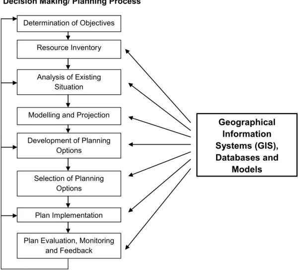
The Decision Support System section consists of two components that make up the support system, namely geographic information systems (GIS) and decision support tools. The Drakensberg Mountains include the physical, ecological, and cultural aspects of the area, current fire management techniques, and optimal prescribed burning techniques based on vegetation needs.
Fire
Fire Behaviour
- Fire Regimes
Season The main factor in fire season is climate, as the natural season of ignition (i.e. lightning) is determined by the climate of the area. However, the probability of a fire (and subsequent behavior if it does catch fire) depends on the current meteorological conditions.
Fire Management
- Prescribed Burning
- Prescribed Burning Techniques
- Fire Breaks
- Biodiversity
- Limitations
- Fire Management in the Future
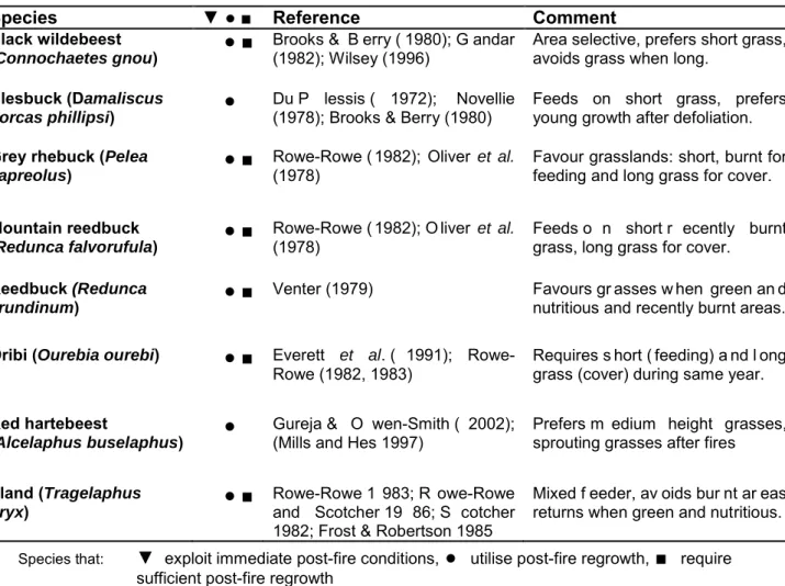
According to De Ronde et al. 2004b), there are many shortcomings in understanding the effects of fire on wildlife. However, long periods without burning also led to a decrease in the number of species present (de Ronde et al. 2004b).
Environmental Decision Support System (EDSS)
- EDSS in Natural Resource Management
- Geographical Information Systems (GIS)
- Use of EDSS in Fire Management
- Conclusion
Therefore, the application of an environmentally based decision support system is crucial (Matthies et al. 2007). An environmental decision support system (EDSS) often consists of several linked environmental models, databases and assessment tools, which are integrated under a graphical user interface (GUI), often achieved by using spatial data and management functionalities provided by geographic information systems. (GIS)” (Matthies et al.
The Drakensberg Mountain Range
- Physical Features
- Geology
- Climate
- Ecology and Biological Diversity
- Flora
- Fauna
- Water and Wetlands
- Cultural Heritage
- Fire in the Drakensberg
- Fire Regimes and Management
- Conservation Management
- Management Constraints
44 The Zulu military power and the rival of the Voortrekkers (Dutch settlers) resulted in the destruction of the K hoisan and the extinction of a human civilization (KNCS 1999). Frequent fires benefit the dominant grass of the Drakensberg and the rest of the southern African grasslands, T. Fire management of the Drakensberg Catchment Area (DCA) has taken four different forms within a relatively short period of time.
Conclusion
This is exacerbated by the lack of management of the Lesotho Highlands, with tourists being attacked while hiking along the border (KNCS 1999). To reduce the abundance of species, the outdoor campaign Frikane Working for Water employs local residents to clear infestations of alien trees in the park, which they can use (ie firewood). To combat this, the locations of most paintings have been removed from public maps with access to the region and sampling in tightly controlled painted caves, accessible only with the presence of a guide (KNCS 1999; Sycholt 2002).

Introduction
Study Site Description
- Introduction
- Flora
- Fauna
- Heritage
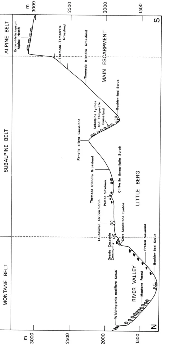
Two notable features are the high proportions of Compositae and Monocotyledons, 285 species and five families respectively, accounting for 55% of the flora (Briggs 2006; Everson and Morris 2006; KNCS 1999; Sycholt 2002). Across the Afro-Alpine area of the Drakensberg, at least 247 of the 394 species occur in the park, of which 98 are endemic or near-endemic (KNCS 1999). None of the mammals are on the internationally threatened species list, however 11 and seven are.
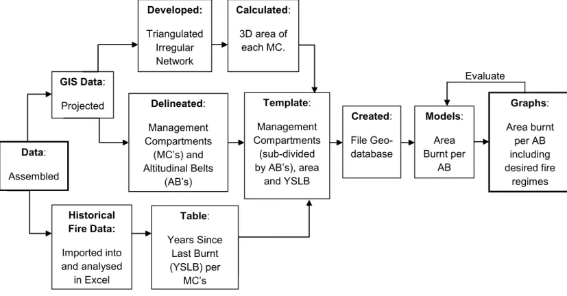
Data Preparation
- Assemblage
- Projections and Programs
- Altitudinal Belts and Management Compartments
- Triangulated Irregular Network (TIN)
- Historical Data
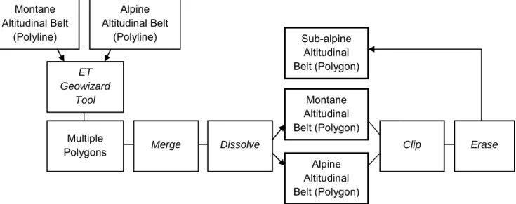
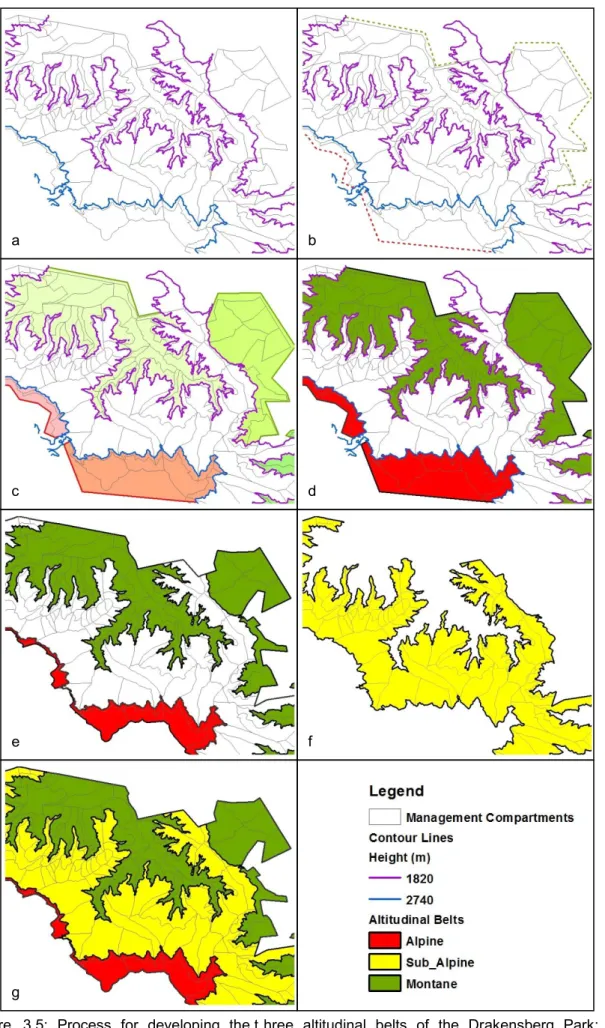
The two bands were snapped at the boundary of the UDP_WHS (study site) (Fig. 3.5e). The Digital Terrain Model (DTM) and relief data (contour lines) of the study site were used to create a triangulated irregular network (TIN) which was used to create the 3D model of the study site (Fig. 3.7c). 65 Figure 3.7: Using the 3D template (a) and the Digital Terrain Model (DTM) (b) of the UDP-WHS to create a Triangulated Irregular Network (TIN) (c), and a three-dimensional representation of the UDP-WHS (d) illustrating the height belts (e).
Model
Graph Template
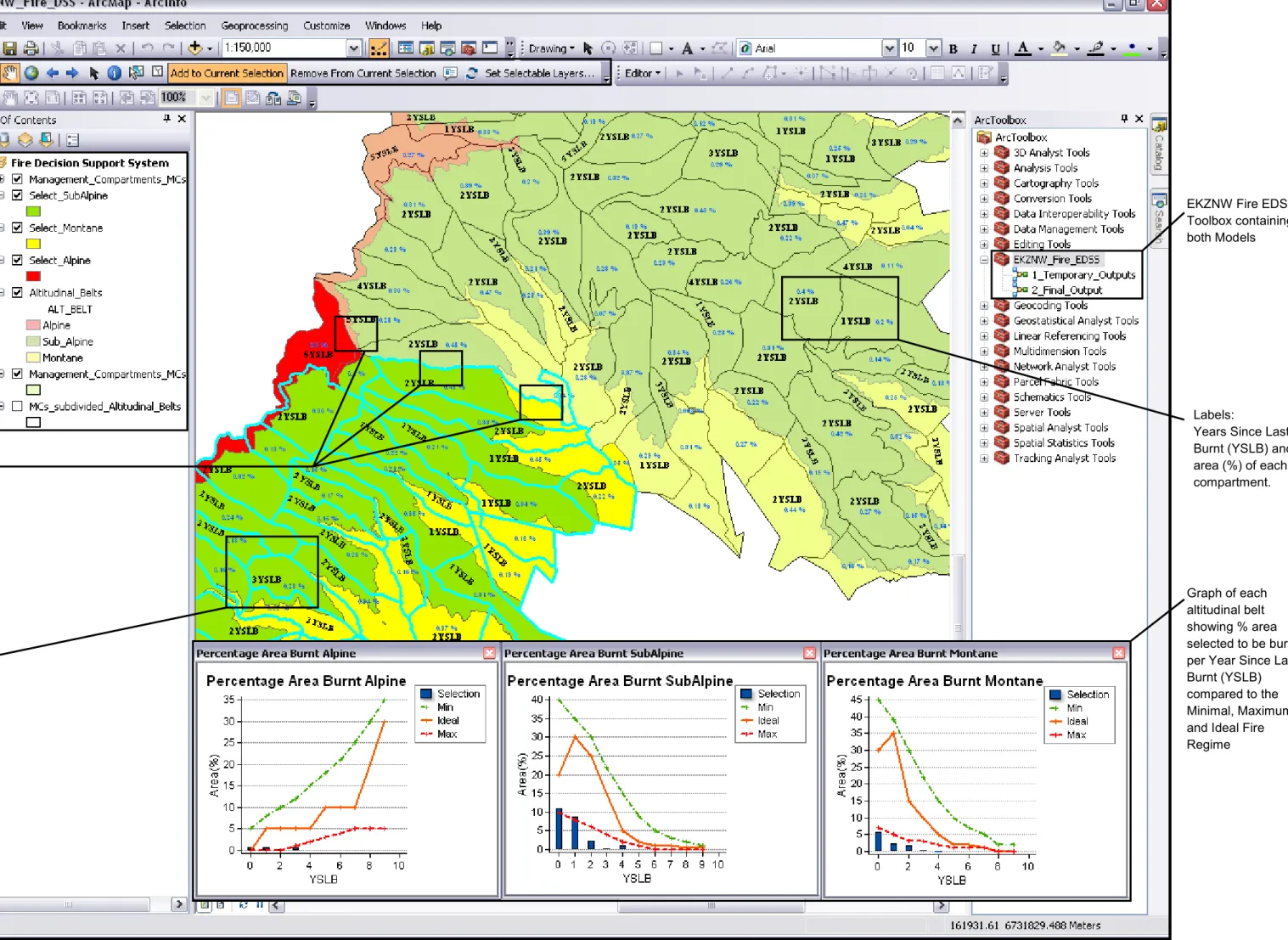
The bar series is based on the park's summary statistics based on percentage area and YSLB. The three-line series are based on nine tables (3 x 3 tables per height band: Minimum, Maximum and Ideal). Once this graph is created, the properties are edited to ensure that all data is displayed and annotated correctly (Fig. 3.11).
Final Output
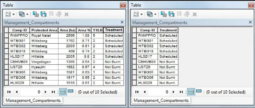
T he input rows are the M Cs feature class, Output Location is the EKZNW_Fire_DSS geodatabase, Output Table: Annual Treatments and the Field Map is where the data not needed is deleted. Step six uses the 'Table to dBase' tool to export the resulting geodatabase table (Input Table) from the previous step to a folder (Output Folder) containing the Excel spreadsheet. The Scheduled and Not Burned entries will be recognized by the Data Validation, and the Years Since Last Burned (YSLB) column will be updated.
Geodatabase
- Fire Regimes
- Annotation
- Precautions
- Toolbar
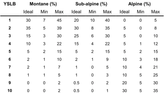
The fire regimes for each altitudinal belt based on percentage of area burned and years since last burning were determined by specialists and workshops with Ezemvelo KZN Wildlife (Fig. 3.13 and Table 3.5). Elevation belt functional classes Provisional prescribed burn selection for each elevation belt (output from a model run). 75 Table 3.5: Fire regime parameters for each elevation belt expressed as a percentage of burned area and years since last burned (YSLB).
Ezemvelo KZN Wildlife (EKZNW) Workshops
To view this map layout information, use the HTML pop-up tool, found on the EKZNW FDSS toolbar. A new "EKZNW FDSS" toolbar was created in the "Customize Mode" menu which opens the toolbar dialog box.
Conclusion
Introduction
Model Results
Temporary Model Outputs
Final Model Output
81 The rooms selected for the prescribed burning in the control room functional class (left) were the entrance to stage one (right). Blank entries are not recorded by the Years Since Last Burnt (YSLB) formula in the excel spreadsheet, and will therefore not be counted in the YSLB column. The Excel document can be updated throughout the year with any treatment in the drop-down list.
Attribute Tables
User Interface
This chapter presents the results (chapter four) and intermediate results (chapter three) of the research. These two models form the main components of the environmental decision support system for fire management in the UDP-WHS. The final environmental decision support system developed for UDP-WHS fire management consists of geodatabase, historical data spreadsheet and ArcMap document.
Digital Terrain Model (DTM) and relief data were used in the development of the Triangulated Irregular Network (TIN) of the UDP-WHS containing management divisions. Ecological effects of fire breaks in the montane grasslands of the southeastern Drakensberg, South Africa.
Environmental Decision Support System (EDSS)
Introduction
Fire, a fundamental feature of planet Earth, remains an evolutionary presence and ecological process of great importance, and control over fire continues to be one of the foundations of human culture (Pyne 1984: vii). This management of the environment preserves the remaining species and their communities, which benefits humans in terms of available resources. The strengths and limitations of the methodology developed in this study will be highlighted, and the EDSS for fire management will be linked to the theoretical framework of the research (Chapter Two).
Research Results
Management Compartments
Fire Management Objectives
Ideal fire regimes, developed from workshops with Ezemvelo KZN Wildlife (EKZNW), were determined and placed on appropriate graphs (Fig. 4.4) to guide fire management decision makers. The regimes take into account the main environmental and biotic factors that influence fire behavior and characteristics, and therefore influence the fire regime of an area. I am confident that, after prolonged prescribed burning according to these graphs using the EKZNW EDSS, the UDP-WHS fire regime will return to an ecologically ideal regime.
Geographical Information Systems (GIS)
Use of Environmental Decision Support Systems
EDSS also provides a means of evaluating and validating decisions made during the decision-making process.
Geodatabase
Methodologies
Prescribed Burning
Precautions
In order to successfully burn this special space without damaging the object in it, special prescribed burning techniques and time are required. However, there is a need for these sensitive areas from the point of view of cultural heritage and tourism, and the need for prescribed burning. Therefore, resources must be provided to ensure that these specific prescribed burning techniques are properly implemented for these sensitive areas with the least amount of vegetation damage to meet both management needs.
Unexpected Burns
Conversely, when special burning techniques are prescribed for individual anthropo-objects, the burning requirements of the vegetation are not taken into account. This flexibility is essential for the managers to make adjustments to the fire management plans. They will be able to change which compartments to burn to continue to meet the burn regime requirements.
Fire Breaks
Many of these fires are out of control and can result in unprescribed out-of-control fires that burn undesignated compartments, severely hampering management efforts to prescribe the environmentally sound fire regime. This therefore requires that the decision support system must be able to receive unexpected updates and add them to the model throughout the year.
Overgrazing
Carbon loss
Spatially-explicit simulation of the effects of prescribed burning on fire regimes and plant extinctions in shrublands typical of southeastern Australia. Contribution of Working Group I to the Second Assessment Report of the Intergovernmental Panel on Climate Change (IPCC). Contribution of Working Group II to the second assessment report of the Intergovernmental Panel on Climate Change (IPCC).
Further Research
Conclusion
The system was developed to make decisions in implementing annual prescribed burns consistent with ideal landscape fire regimes.
Introduction
Objectives
Identify t he uK hahlamba D rakensberg P ark World H eritage S ite ( UDP- WHS)
The outcomes of these workshops were the theoretical ideal fire regimes and management objectives of each elevation belt appearing in the UDP-WHS. This allowed the visual representation of the minimum, maximum and ideal percentage area per year since the last burn for each elevation belt and the development of the precautionary feature class. Therefore, the objectives of 'Determine the fire management objectives of the UDP-WHS', 'Gather information on various aspects of the UDP-WHS' and consultations and workshops with Ezemvelo KZN Wildlife were achieved.
Development of environmental decision support models
97 Heritage Area Boundaries (UDP-WHS) and elevation zoning were achieved" and "creation of a template, containing management polygons (compartments) and compartment identification number".
Create a geodatabase housing the fire management decision support system
Saving an excel document within a geodatabase results in the document presenting statistical functionality. Therefore, the objective of 'creating a geodatabase that houses the fire management decision support system' was achieved, but with the limitation of being completely non-functional. This was overcome by placing the geodatabase together with the excel document and other features within one folder.
Aim
98 was not used due to the requirement of the Excel spreadsheet not being able to be saved to a geodatabase. Therefore, that one folder can be a standalone tool, retaining the functionality of all the features within it.
Conclusion
An account of the plant ecology of the Cathedral Peak area of the Natal Drakensberg. Ecology of the southern reedbuck Redunca arundinum Boddaert 1785 on the eastern shore of Lake St. Lucia. Ignition is started simultaneously by all burners at the top of the hill, which move downhill in a star-like pattern at equal speed.