Abel Tasman Foreshore
Scenic Reserve Management Plan
June 2012
Partially reviewed November 2015
Abel Tasman Foreshore Scenic Reserve Management Plan
June 2012
Partially reviewed November 2015
Published by:
Tasman District Council and Department of Conservation Private Bag 4 Nelson Marlborough Conservancy
Richmond Private Bag 5
New Zealand Nelson, New Zealand
Cover - all photos by Diana Parr except as follows: Awaroa baches – Jen Andrews; Abel Tasman Wilson’s Experience Vista – Martin Rodd; children leaping – Rob Greenaway; snorkelers – Elizabeth Bean; kayakers and Marahau Beach Camp water taxi - Grant Reburn; Torrent Bay – Eric Verstappen; Hui Te Rangiora (carved tekoteko on the gable of the meeting house, Turangapeke, at Te Awhina Marae, Motueka) – Rudy Tetteroo.
© Copyright 2015, Tasman District Council and New Zealand Department of Conservation
ISBN: 978-0-473-34465-8 (print) ISBN: 978-0-473-34466-5 (online)
Contents
Preface ... 9
The Abel Tasman Foreshore Scenic Reserve ... 12
Vision ... 13
Primary Objectives ... 13
Outcomes at places ... 13
How to use this plan ... 14
Part A - Matters relating to Abel Tasman Foreshore Scenic Reserve as a whole……….14
1. Introduction ... 15
1.1 Management planning and legislative context ... 15
1.1.1 Abel Tasman Foreshore Scenic Reserve, adjacent lands and coastal waters ... 15
1.1.2 Legislative context ... 15
1.2 Administration ... 16
1.2.1 Administration Committee ... 16
1.2.2 Management Plan Approval Committee ... 16
1.2.3 Nelson Marlborough Conservation Board ... 16
2. Treaty of Waitangi ... 17
2.1 Giving effect to the Treaty ... 17
2.2 Customary use ... 18
2.2.1 Legislation ... 19
2.2.2 Fishing (including shellfish) and seaweed harvesting ... 19
2.2.3 Dead animals and plants ... 19
2.3 Access for kaitiaki responsibilities and cultural activities ... 20
3. Conservation of natural resources ... 22
3.1 Terrestrial, freshwater and marine species, habitats and ecosystems ... 22
3.1.1 Protection, restoration and preservation ... 25
3.1.2 Fishing and the taking of seaweed and driftwood ... 26
3.1.3 Survey, monitoring and research ... 26
3.2 Biosecurity and management of threats to indigenous species, habitats and ecosystems ... 27
3.2.1 Animal pests ... 28
3.2.2 Plant pests ... 28
3.2.3 Biosecurity ... 29
3.2.4 Other threats ... 29
3.3 Fire management ... 30
3.4 Geological features, landforms, and landscape ... 31
3.4.1 Development and preservation ... 32
3.5 Ecosystem services ... 34
4. Historical and cultural heritage ... 35
4.1.2 European history ... 36
4.1.3 Recent history ... 36
4.2 Management of historical and cultural heritage ... 36
4.2.1 Protection of historic places... 36
4.2.2 Protected objects ... 37
4.2.3 Māori sites ... 38
4.2.4 European sites, relics, and protected New Zealand objects ... 38
4.2.5 Threats ... 38
4.2.6 Interpretation... 39
4.2.7 Memorials ... 39
5. Natural hazards ... 42
6. People’s benefit and enjoyment ... 43
6.1 Planning and management for people’s benefit and enjoyment ... 43
6.1.1 Access and use ... 44
6.1.2 Visitor experiences ... 45
6.1.3 Recreational Zones ... 46
6.1.4 Monitoring ... 59
6.1.5 Noise ... 59
6.1.6 Camping and overnight stays in vessels ... 59
6.1.7 Educational and other large groups ... 60
6.1.8 Human waste and litter ... 60
6.1.9 Information including interpretation ... 61
6.1.10 Advocacy ... 61
6.2 Sports fishing and game bird hunting ... 63
6.3 The use of vehicles and other forms of transport ... 64
6.3.1 Land vehicles ... 64
6.3.2 Vessels ... 64
6.3.3 Aircraft ... 65
6.4 Animals ... 65
6.4.1 Horses ... 66
6.4.2 Dogs ... 66
6.4.3 Other domestic animals ... 66
7. Accommodation and related facilities ... 68
7.1 Accommodation ... 68
7.2 Other facilities and structures ... 68
7.2.1 Monitoring ... 69
8. Activities requiring specific authorisation ... 71
8.1 Concessions - general ... 71
8.1.1 Processing concession applications ... 71
8.1.2 Concession management ... 71
8.1.3 Historic cultural values ... 72
8.1.4 Concession monitoring ... 72
8.2 Recreation concessions ... 73
8.2.1 Recreation concession management ... 73
8.2.2 Water-based commercially guided activity ... 76
8.2.3 Water taxi activity ... 77
8.2.4 Charter boat activity ... 80
8.2.5 Support vessel activity ... 80
8.2.6 Servicing floating accommodation activity ... 81
8.2.7 Commercially guided walking activity ... 81
8.2.8 Freedom water-based commercial activity ... 81
8.2.9 Cruise ships ... 82
8.2.10 Organised sporting events... 83
8.2.11 Sale or hire of goods and equipment ... 83
8.2.12 Personal watercraft, hovercraft, amphibious vessels, other unconventional vessels and parasailing ... 83
8.2.13 Land vehicles ... 83
8.2.14 Aircraft ... 83
8.2.15 Noise ... 84
8.2.16 Advertising ... 84
8.2.17 Other concession activities ... 84
8.2.18 Monitoring ... 85
8.3 Non-recreation concessions ... 90
8.3.1 Utilities ... 90
8.3.2 Easements ... 90
8.3.3 Aircraft ... 90
8.3.4 Coastal fishing ... 90
8.3.5 Removal of sand, shingle or other natural mineral material ... 91
8.3.6 Commercial filming and photography ... 91
8.3.7 Monitoring ... 91
8.4 Other authorisations for non-commercial activities ... 93
8.4.1 Processing applications for an authorisation ... 93
8.4.2 Scientific research ... 94
8.4.3 Monitoring ... 94
9. Community relations ... 96
9.1 Public participation in management of the reserve ... 96
9.1.1 Local economies ... 96
9.1.2 Consultation ... 96
9.1.3 Abel Tasman Foreshore Advisory Forum ... 97
9.1.4 Neighbouring lands ... 97
9.1.5 Unformed legal roads, accreted land and other additions ... 98
9.1.6 Aircraft ... 98
9.1.7 Coastal waters ... 98
9.1.8 Discharges from vessels ... 103
9.1.9 Water and land-based commercial activity ... 103
9.1.10 Moorings and other structures ... 104
10. Implementation, monitoring, reporting, and review ... 106
10.1 Plan implementation, monitoring, reporting and review ... 106
10.1.1 Implementation ... 106
10.1.2 Monitoring ... 106
10.1.3 Reporting ... 106
10.1.4 Review ... 106
10.2 Compliance and law enforcement ... 107
10.3 Helicopter, vehicle and vessel use ... 107
Part B - The places within Abel Tasman Foreshore Scenic Reserve……….110
11. Foreshore Adjacent to Private Land ... 112
11.1 Spatial definition of Foreshore Adjacent to Private Land ... 112
11.2 Outcome for Foreshore Adjacent to Private Land ... 112
11.3 Long-term objectives for Foreshore Adjacent to Private Land ... 113
11.4 Conservation of natural resources ... 113
11.4.1 Protection ... 113
11.4.2 Pest management ... 113
11.5 People’s benefit and enjoyment ... 114
11.5.1 Visitor experiences ... 114
11.5.2 Recreational Zones ... 115
11.5.3 Land vehicles ... 116
11.5.4 Vessels ... 116
11.5.5 Dogs ... 119
11.5.6 Educational and other large groups ... 119
11.5.7 Advocacy ... 119
11.6 Facilities and structures ... 120
11.7 Activities requiring specific authorisation ... 120
11.7.1 Recreation concessions ... 120
11.7.2 Non-recreation concessions ... 124
12. Foreshore Adjacent to National Park ... 126
12.1 Spatial definition of Foreshore Adjacent to National Park ... 126
12.2 Outcome for Foreshore Adjacent to National Park ... 126
12.3 Long-term objective for Foreshore Adjacent to National Park ... 126
12.4 Conservation of natural resources ... 127
12.4.1 Protection, restoration and preservation ... 127
12.4.2 Seals ... 127
12.4.3 Island biosecurity and threat management ... 128
12.5 People’s benefit and enjoyment ... 128
12.5.1 Access ... 128
12.5.2 Visitor experiences ... 128
12.5.3 Recreational Zones ... 129
12.5.4 Land vehicles ... 130
12.5.5 Vessels ... 130
12.5.6 Dogs ... 130
12.6 Facilities and structures ... 131
12.7 Activities requiring specific authorisation ... 132
12.7.1 Recreation concessions ... 132
Glossary ... 137
Bibliography ... 149
Appendix 1 Management planning... 150
Appendix 2 Legislation and statutory documents ... 153
Appendix 3 Abel Tasman Foreshore Scenic Reserve creation, management and delegations ... 159
Appendix 4 Indigenous animal and plant species likely to be found within, or in the vicinity of, the reserve ... 162
Appendix 5 ‘Threatened’ and ‘at risk’ indigenous plants and animals of Abel Tasman Foreshore Scenic Reserve ... 167
Appendix 6 Schedule 25.1F, Tasman Resource Management Plan: Areas with nationally or internationally important natural ecosystem values (within the coastal marine area) .... 170
Appendix 7 Processes and principles for setting maximum activity levels for water taxi and charter boat activity ... 171
Appendix 8 Summary of charter boat activity ... 173
Appendix 9 Conservation General Policies (2005) referred to in this plan ... 174
Maps
Map 1: Location of Abel Tasman Foreshore Scenic Reserve 11
Map 2: Recreational Zones 47
Map 2A: Anchorage Coastal Access Points 50
Map 2B: Torrent Bay/Rakauroa Coastal Access Points 51
Map 2C: Medlands Bay and Bark Bay/Wairima Coastal Access Points 52 Map 2D: Onetahuti Coastal Access Point and the designated landing area for water taxis at
Tonga Quarry
53 Map 2E: Awaroa Beach and Sawpit Point Coastal Access Points 54
Map 2F: Totaranui Coastal Access Point 55
Map 2G: Awaroa Vehicle Access Corridor 57
Map 3: Unalienated Crown land, Tinline Bay and Coquille Bay 99 Map 4: Unalienated Crown land, Apple Tree Bay/Whenuakura and Stilwell Bay 100 Map 5:
Unformed legal road, reserve land and unalienated Crown land, Torrent
Bay/Rakauroa, Boundary Bay, Frenchman Bay/Potikitawa and Sandfly Bay 101
Map 6: Foreshore adjacent to Abel Tasman Memorial 102
Map 7: Places 110
Maps 7A, 7B & 7C: Foreshore Adjacent to Private Land detail 111
Map 8: Awaroa Spit bird nesting/roosting area 117
Map 9: Venture Creek swimming area 118
Map 10: One nautical mile from the Abel Tasman Foreshore Scenic Reserve Tables
139
Table 1: Maximum levels of water-based commercially guided activity
77
Table 2: Maximum levels of water taxi activity 79
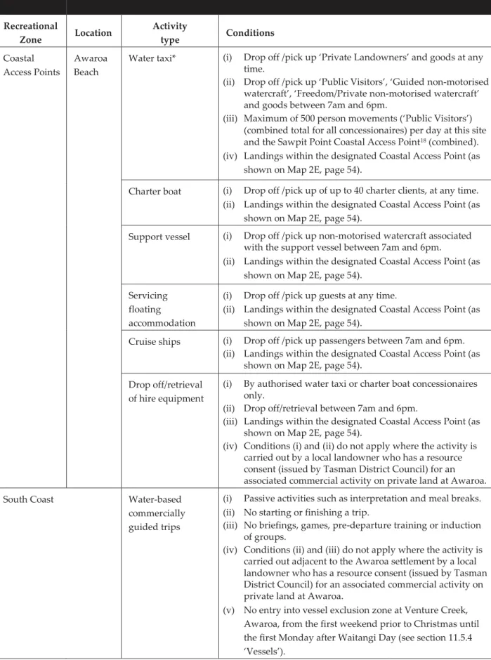
Table 3: Maximum number of trips for charter boat activity 80 Table 4: Maximum number of visits for cruise ship activity 82 Table 5: Conditions for recreation concession activities on the Foreshore Adjacent to Private
Land
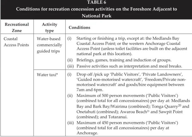
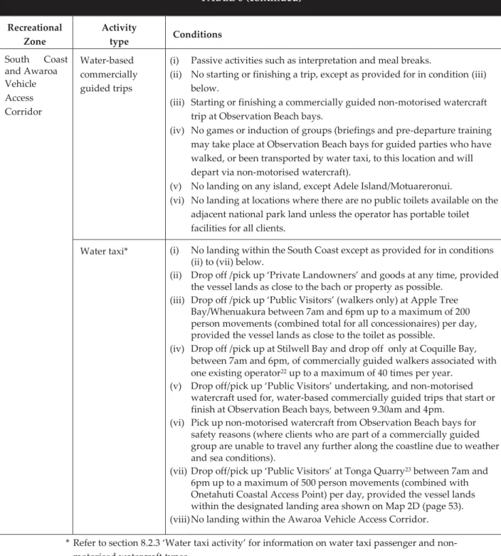
121 Table 6: Conditions for recreation concession activities on the Foreshore Adjacent to
National Park
132
Preface 9
Preface
The Abel Tasman Foreshore Scenic Reserve was gazetted as a scenic reserve in January 2007. It is managed under delegated authority from the Minister of Conservation and the Director-General of Conservation by an Administration Committee, which consists of the Chief Executive Officer of Tasman District Council and the Conservator of the Nelson Marlborough Conservancy of the Department of Conservation.
This Management Plan for the Abel Tasman Foreshore Scenic Reserve has been prepared by the Administration Committee in accordance with section 40B of the Reserves Act 1977. This plan is a statutory document that implements the Nelson Marlborough Conservation Management Strategy and provides for the management of the Abel Tasman Foreshore Scenic Reserve in accordance with the Reserves Act 1977, the Conservation Act 1987 and Conservation General Policy 2005.
This plan has been developed in consultation with the Abel Tasman Foreshore Advisory Forum and representatives from tangata whenua, the Nelson Marlborough Conservation Board, the local community and other interested groups and individuals.
The draft plan was publicly notified on 8 June 2011, 104 submissions were received, and hearings were held in November and December 2011. The Management Plan Approval Committee took these submissions into account when revising the draft plan.
The plan was approved by the Management Plan Approval Committee on 25 June 2012, and will be effective from 1 November 2012 until 2018 (to coincide with the review of the Abel Tasman National Park Management Plan, which was approved in October 2008), but a review (either in part or in full) may occur at any time due to increased knowledge or changes in circumstance.
25 June 2012
By appointment and under delegated authority from the Minister of Conservation, the Director-General of Conservation and the Nelson Marlborough Conservation Board.
On 12 August 2015 the Administration Committee (at that time, the Chief Executive Officer of Tasman District Council and the Director Partnerships, North and Western South Island Region, Department of Conservation) publicly notified a partial review of the plan, focusing on four issues relating to access to the reserve.
Eleven submissions were received and the Management Plan Approval Committee held a hearing on 30 October 2015. In November 2015, the Management Plan Approval Committee approved the revised plan to:
(i) enable access to the reserve for kaitiaki responsibilities and non-commercial cultural activities;
(ii) provide for an increase in use of Observation Beach bays and a corresponding reduction in use of the adjacent Watering Cove;
(iii) provide for ongoing use of Tonga Quarry by water taxis on a trial basis; and (iv) specify provisions relating to drop off/retrieval of hire equipment from the
reserve.
The revised plan took effect on 27 November 2015.
The Management Plan Approval Committee
Lindsay McKenzie Chief Executive Officer Tasman District Council
Jan Hania
Director Partnerships Department of Conservation
Trevor Norriss Councillor
Tasman District Council
Bob Dickinson Chairperson
Nelson Marlborough Conservation Board
Joy Shorrock Iwi representative
Te Ātiawa o Te Waka-a-Māui
Mairangi Reiher Iwi representative Manawhenua ki Mohua 27 November 2015
By appointment and under delegated authority from the Minister of Conservation, the Director-General of Conservation and the Nelson Marlborough Conservation Board.
11
Map 1: Location of Abel Tasman Foreshore Scenic Reserve
The Abel Tasman Foreshore Scenic Reserve
The Abel Tasman coast is significant in terms of its scenic values. It has a diverse range of coastal landforms, including estuaries, sandy beaches, rocky headlands, rock stacks, islets and islands. Indigenous vegetation within Abel Tasman National Park forms the backdrop for most of the foreshore. The coastal scenery, golden-sand beaches, relatively sheltered coastal waters and bays attract thousands of visitors to the foreshore each year, via the tracks within the national park or from the coastal waters by a variety of vessels. The foreshore is also used and enjoyed by residents and visitors to the numerous private landholdings adjoining the reserve.
After much discussion about the most appropriate way of managing the Abel Tasman coast, the Abel Tasman Foreshore Scenic Reserve (‘the reserve) was gazetted as scenic reserve on 25 January 2007, under section 19(1)(a) of the Reserves Act 1977 (by the Minister for Land Information). At the time the reserve was created the Foreshore and Seabed Act 2004 was in force. This vested the ownership of the public foreshore and seabed in the Crown, and the Gazette notice (reserving the land under the Public Works Act 1981) specifically stated that the land would remain vested in the Crown. As a result of foreshore coming under the jurisdiction of the Reserves Act 1977, the Minister of Conservation became responsible for it.
The reserve comprises 774 ha of foreshore, predominantly a narrow strip of land (other than in the estuaries) that lies between the Mean High Water Mark and Mean Low Water Springs, along the Abel Tasman coastline in the northwest of the South Island. It straddles Tasman Bay and Golden Bay, as shown on Map 1 (page 11). A large portion of the reserve adjoins land protected within Abel Tasman National Park, including the foreshore of all the islands in the park. Other parts of the reserve adjoin privately- owned land and reserves administered by Tasman District Council, including areas of formed and unformed road reserve. The central part of the reserve, between Awaroa Bay and Bark Bay/Wairima, is overlain by the Tonga Island Marine Reserve.
The reserve is managed by an Administration Committee (see section 1.2.1
‘Administration Committee’ and Appendix 3), which arose from recommendations of the Abel Tasman Foreshore Advisory Forum (see section 9.1.3 ‘Abel Tasman Foreshore Advisory Forum’). This makes the reserve unique. No other area of foreshore in the country is a scenic reserve under the administration of a committee made up of representatives from a territorial authority and the Department of Conservation.
The primary purpose of designating the foreshore as scenic reserve was to maintain the quality of the visitor experience while protecting the natural features that make the Abel Tasman foreshore so special, including the scenic character of the coastline. The focus of this management plan is three-fold:
(i) Continuing to allow the public and adjoining landholders to use and enjoy the area as they have for many years, with few constraints
(ii) Maintaining and enhancing the experiences of visitors and adjoining landholders (iii) Reducing and mitigating the effects of visitor use, particularly through
management of commercial activities.
Vision/Primary Objectives/Outcomes at places 13
Vision
The Abel Tasman Foreshore Scenic Reserve is revered and safeguarded for all those who come after us.
Primary Objectives
Section 40B(1) of the Reserves Act 1977 states that the purpose of a management plan includes the establishment of objectives for the management of the reserve according to the purpose for which the reserve is classified. Conservation General Policy 13(a)ii and vii (see Appendix 9) also states that this plan should identify planned outcomes,
objectives and policies, consistent with the purpose for which the scenic reserve is held;
and have regard to integrated management to achieve national conservation outcomes, and to coordinate planning between places covered by other strategies and plans.
The Primary Objectives for the Abel Tasman Foreshore Scenic Reserve are:
1. Effect given to achieving the Vision, and the outcomes for the Foreshore Adjacent to Private Land and the Foreshore Adjacent to National Park places
2. Preservation of the natural ecosystems and landscapes, the indigenous species of flora and fauna in their natural communities and habitats, and the natural character of the coastal environment, of the reserve
3. Preservation of public access to and along the Abel Tasman coast, and its bays and inlets and offshore islands (except Tonga and Pinnacle Islands)
4. Protection and preservation or enhancement, for the benefit, enjoyment and use of the public, of the intrinsic values of the reserve as an area possessing great beauty, natural features and landscapes
5. Management and protection of the historical, archaeological, biological and other scientific features of the reserve, to the extent compatible with the other Primary Objectives
6. Regard given to the collective cultural values of the reserve
7. Effect given to the principles of the Treaty of Waitangi, to the extent that they are consistent with the provisions of the Reserves Act 1977
8. Integrated management and use compatible with that of adjacent lands and waters (including Abel Tasman National Park, Tonga Island Marine Reserve, the adjacent coastal marine area and privately owned land), to the extent that it is consistent with the provisions of the Reserves Act 1977
Outcomes at places
This plan applies the concept of ‘outcomes at places’ for the management of the reserve.
The reserve is dealt with as a whole and as two places: Foreshore Adjacent to Private Land; and Foreshore Adjacent to National Park (see Part B and Maps 7, 7A, 7B and 7C, pages 109-111). The Outcomes are descriptions of what the two places will be like in 10 years time, which in large part reflect what they are like now (see sections 11.2 Outcome for Foreshore Adjacent to Private Land and 12.2 Outcome for Foreshore Adjacent to National Park).
How to use this plan
The plan is divided into two parts:
1. Part A covers matters relating to the reserve as a whole -
Chapter 1 addresses the management planning and legislative context for the reserve. This is followed, in Chapter 2, by an explanation of the significance of the Treaty of Waitangi and customary use in the reserve.
Chapters 3 - 8 identify the values of the reserve, address issues associated with these values, and set out policies and methods for the reserve as a whole.
Chapter 9 deals with issues that the Administration Committee does not have direct control over.
Chapter 10 outlines the requirements in relation to the implementation, monitoring, reporting and review of this plan.
2. Part B covers the detailed management of the two places in the reserve - Chapter 11 deals with the Foreshore Adjacent to Private Land and Chapter 12
deals with the Foreshore Adjacent to National Park. Specific long term outcomes and objectives are identified for each place. Policies and methods are provided where there are specific issues that need addressing in each place, which are in addition to the provisions in Chapters 3 – 8.
To help identify these provisions further, the pages of Chapter 11 (Foreshore Adjacent to Private Land) are golden coloured and the pages of Chapter 12 (Foreshore Adjacent to National Park) are green coloured.
There is also a footnote at the bottom of each page to help identify what part of the plan you are in.
Please note that, when viewing the contents of this plan, it is important to read and consider the plan provisions as a whole. Various objectives, policies and methods may influence the interpretation of other parts of the plan.
1. Introduction 15
Part A
Matters relating to Abel Tasman
Foreshore Scenic Reserve as a whole
1. Introduction
1.1 Management planning and legislative context
The provisions in this plan set out the expectations and guidance as to the overall management of the reserve by the Administration Committee, subject to availability of resources and community support. The process for preparing this plan is set out in Appendix 1.
An explanation of the objectives, policies, methods and outcomes in this plan is provided in Appendix 1, as is an explanation on animal and plant classification.
1.1.1 Abel Tasman Foreshore Scenic Reserve, adjacent lands and coastal waters
Appendix 1 identifies the physical extent of the reserve, and its relationship to the adjacent lands and coastal waters.
Reserve name
The reserve was not officially named when it was created in 2007. However, the New Zealand Geographic Board/Ngā Pou Taunaha o Aotearoa subsequently gave notice that the official reserve name was ‘Abel Tasman Scenic Reserve’ (NZ Gazette 2009 No. 73, pg 1700). The Administration Committee intends to submit a proposal to the Geographic Board to alter the English name to ‘Abel Tasman Foreshore Scenic Reserve’, along with an appropriate te reo Māori name, in consultation with iwi.
1.1.2 Legislative context
This management plan gives effect to the Reserves Act 1977, the Conservation Act 1987, Conservation General Policy 2005, and the Nelson Marlborough Conservation Management Strategy. The relevant legislation and other statutory documents that affect the management and administration of the reserve are provided in Appendix 2.
Where any inconsistencies arise then the legislation shall prevail in the first instance, followed by the Conservation General Policy 2005 and the Conservation Management Strategy.
Bylaws and general authorisation
Under section 106(3) of the Reserves Act 1977, the Minister of Conservation may make bylaws for the reserve for a number of matters (such as controlling access and other activities). Such bylaws should be necessary for the proper administration and control of the reserve. There are bylaws for the reserve that regulate some activities and allow others that would otherwise be an offence under the Reserves Act 1977, such as walking a dog. This management plan proposes a number of amendments and additions to the bylaws. The Minister is responsible for approving any amendment to the bylaws in accordance with section 108 of the Reserves Act 1977.
There is also a general authorisation, issued by the Administration Committee, that provides for other activities that would otherwise be an offence under the Reserves Act 1977. The activities are: the use of traps, nets or fishing lines; the taking of fish and shellfish; the taking of seaweed; and the taking of driftwood. This management plan proposes some amendments to the general authorisation.
1.2 Administration
1.2.1 Administration Committee
An Administration Committee is responsible for the administration and management of Abel Tasman Foreshore Scenic Reserve in accordance with this management plan. The Administration Committee comprises the Chief Executive Officer of Tasman District Council and the Conservator of the Nelson Marlborough Conservancy of the
Department of Conservation. This statutory body was appointed by the Minister of Conservation under Section 9 of the Reserves Act 1977, with delegated powers and functions to administer and manage the reserve. The Director-General of Conservation has also delegated the powers of a Commissioner (under the Reserves Act 1977) to the committee (see Appendix 3).
The Administration Committee manages the reserve through Tasman District Council’s Main Office in Richmond and the Department of Conservation’s Nelson Marlborough Conservancy Office in Nelson. Staff from these offices and the Area Offices of the Council and the Department, in Motueka and Takaka, are responsible for day-to-day operational management. Where appropriate, some of the
Administration Committee’s powers and functions may be carried out by these staff.
1.2.2 Management Plan Approval Committee
The Management Plan Approval Committee is a subcommittee of the Nelson
Marlborough Conservation Board, formed in accordance with section 6N(2)(b) of the Conservation Act 1987. It comprises the Conservation Board chairperson, the Chief Executive Officer of Tasman District Council, the Conservator of the Nelson
Marlborough Conservancy of the Department of Conservation, one Tasman District Council nominee and two nominees from tangata whenua.
The Management Plan Approval Committee was responsible for hearing submissions on the draft management plan, requesting revisions to the plan, and approving the plan (see Appendix 3). Now the plan is approved, the Management Plan Approval
Committee’s role ceases, unless an amendment to the plan is proposed or until such time as the plan is reviewed (see section 10.1.4 ‘Review’).
1.2.3 Nelson Marlborough Conservation Board
When this plan is approved the Nelson Marlborough Conservation Board is responsible for advising the New Zealand Conservation Authority and the Director-General of Conservation on the implementation of this plan, which includes the issuing of
concessions for the reserve, in accordance with section 6M(1)(c) of the Conservation Act 1987 and Conservation General Policy 13(e) and (f) (see Appendix 9).
2. Treaty of Waitangi 17
2. Treaty of Waitangi
2.1 Giving effect to the Treaty
Under section 4 of the Conservation Act 1987, the Administration Committee is required to interpret and administer the Reserves Act 1977 to give effect to the
principles of the Treaty of Waitangi. However, where there is clearly an inconsistency between the provisions of the Reserves Act 1977 and the principles of the Treaty, the provisions of the Reserves Act 1977 will prevail. This is reflected in the Primary Objectives for the reserve.
This plan is subject to the developing jurisprudence of the courts on the interpretation of the principles of the Treaty of Waitangi and to the outcome of Treaty Settlement negotiations, and should be read together with the Conservation General Policy 2005, particularly Chapter 2; and policies 4.1(e), 4.4(h), 5(c) and 12(d) (see Appendix 9). Any Treaty settlement legislation passed during the lifetime of this plan will be given effect to.
In this plan, the tangata whenua whose rohe (tribal boundaries) cover the Abel Tasman Foreshore Scenic Reserve are Ngāti Tama Ki Te Tau Ihu (Ngāti Tama), Te Ātiawa Ki Te Tau Ihu (Te Ātiawa) and Ngāti Rārua, as kaitiaki manawhenua, and also other iwi who may be recognised by the Crown as being tangata whenua of the reserve.
The Administration Committee needs to work co-operatively with tangata whenua, in a spirit of partnership (based on mutual good faith, co-operation and respect) to achieve the objectives of this plan. A partnership approach recognises the mana of tangata whenua and the desire to work together to maintain and support the reserve.
Tangata whenua need to be given the opportunity to be actively involved in the preservation of the reserve’s values, including wāhi tapu and other taonga. The Administration Committee recognises and respects the desire of tangata whenua to exercise kaitiakitanga/customary practices of guardianship, in relation to places or resources that have spiritual or historical and cultural significance for them. Active involvement by tangata whenua can be supported and achieved in a number of different ways. Some of these ways are:
(i) Providing tangata whenua with information and technical advice
(ii) Communicating with tangata whenua about proposed work associated with the reserve
(iii) Consulting tangata whenua regarding the protection of wāhi tapu and other taonga (see section 4.2 ‘Management of historical and cultural heritage’) (iv) Establishing partnerships with tangata whenua on restoration and pest
management projects, where appropriate (see section 3.2 ‘Biosecurity and management of threats to indigenous species, habitats and ecosystems’)
(v) Enabling customary use by tangata whenua on a case-by-case basis (see section 2.2 ‘Customary use’)
(vi) Consulting with tangata whenua on concession applications that affect their interests (see section 8.1.3 ‘Māori cultural values’)
(vii) Developing public information and interpretation which refers to places or resources of spiritual or historical and cultural significance to Māori, in
consultation with tangata whenua (see section 4.2 ‘Management of historical and cultural heritage’).
There are two iwi representatives (one nominated by Tiakina te Taiao Ltd1 and one nominated by Manawhenua ki Mohua2) on the Management Plan Approval
Committee (see section 1.2.2 ‘Management Plan Approval Committee’); and three iwi representatives on the Abel Tasman Foreshore Advisory Forum (see section 9.1.3 ‘Abel Tasman Foreshore Advisory Forum’).
Consultation from the early stages of any proposed undertaking that may affect the interests of tangata whenua and full consideration of their views is essential.
At the time of approving this plan there were claims registered with the Waitangi Tribunal that affect some areas of the reserve, including Adele Island/ Motuareronui, Fisherman Island/Motuarero-iti and some land at Anchorage. In the event that the settlement of any Treaty claim affects the management of the reserve, this should be addressed through the Treaty settlement legislation. The Administration Committee seeks to avoid any actions which would be a breach of the principles of the Treaty of Waitangi.
2.1 Policy
1. To give effect to the principles of the Treaty of Waitangi, to the extent that they are consistent with the provisions of the Reserves Act 1977.
2.1 Methods
1. Encourage and support tangata whenua involvement and participation in the protection and preservation of the reserve, including the provision of information and cultural advice.
2. Regularly communicate with tangata whenua about management work proposed for the reserve.
3. Actively consult with tangata whenua throughout the term of this plan regarding its implementation.
2.2 Customary use
Māori have traditionally gathered plants and animals from the land and water for customary use (the gathering and use of natural resources by tangata whenua according to tikanga). There has been a revival of former traditions and the use of customary materials including, but not limited to: indigenous plants used in weaving and for rongoā/medicine; and indigenous birds and animals for their feathers and for food. Many of the traditional materials and indigenous species remaining today are found on lands administered by Tasman District Council and the Department of Conservation, and may be requested by tangata whenua. When tangata whenua wish
1 Represents the iwi of Nelson and Tasman - Ngāti Rārua, Te Ātiawa, Ngāti Tama and Ngāti Koata.
2 Represents the iwi of Golden Bay - Ngāti Rārua, Te Ātiawa and Ngāti Tama.
2. Treaty of Waitangi 19 to undertake customary use in the reserve they should contact the Department of Conservation’s Pou Kura Taiao/Iwi Manager in the first instance.
2.2.1 Legislation
The classification of Abel Tasman Foreshore Scenic Reserve as a scenic reserve under section 19(1)(a) of the Reserves Act 1977 provides a high degree of protection to its indigenous plants and animals. The Reserves Act 1977 states that:
3(1)(b) ‘Ensuring, as far as possible, the survival of all indigenous species of flora and fauna, both rare and commonplace, in their natural communities and habitats…
19(2)(a) ‘… the indigenous flora and fauna, ecological associations … shall as far as possible be preserved …’
An authorisation (see section 8.4 ‘Other authorisations for non-commercial activities’) is required for customary use, except for fishing and seaweed harvesting (see section 2.2.2
‘Fishing (including shellfish) and seaweed harvesting’). Conservation General Policies 2(g) and 4.1(e) (see Appendix 9) set out the criteria by which the customary use of traditional materials and indigenous species may be authorised.
In addition, Conservation General Policy 4.4(h) (see Appendix 9) identifies that tangata whenua will be provided with access to the remains of dead marine protected species for customary use consistent with relevant legislation and agreed protocols.
Given the reserve context, both the Administration Committee and tangata whenua, as kaitiaki/guardians, have a responsibility to ensure that indigenous plants and animals are preserved for future generations.
2.2.2 Fishing (including shellfish) and seaweed harvesting
Except within Tonga Island Marine Reserve, customary use of fish (including shellfish, whitebait and eels) and seaweed within the Abel Tasman Foreshore Scenic Reserve is provided for under Conservation General Policy 2(g), 4.1(e), 4.1(f) and 4.4(h) (see Appendix 9). Non-commercial customary use is permitted, subject to the general
authorisation and relevant fisheries legislation. (See section 3.1.2 ‘Fishing and the taking of seaweed and driftwood’ for non-customary fishing and harvesting.)
When the foreshore was classified as a scenic reserve, the right to take or kill indigenous fauna for commercial fishing purposes was retained as a condition of establishment of the reserve. A concession is required for commercial fishing or taking of seaweed. Any applications to undertake commercial customary takes of fish or seaweed should be declined, in accordance with section 8.3.4 ‘Coastal fishing’.
2.2.3 Dead animals and plants
If an animal of cultural significance to tangata whenua dies, or washes up dead, on the reserve; or a tree of cultural significance to tangata whenua falls onto the reserve, then the materials should be offered to tangata whenua for customary use. Regard needs to be given to Conservation General Policy 4.4(h) (see Appendix 9) as well as protocols developed with tangata whenua, particularly in relation to dead marine mammals.
2.2 Policy
1. To provide for the customary use of traditional materials and indigenous species in the reserve by tangata whenua in accordance with Conservation General Policy 2005, and the provisions of this plan.
2.2 Methods
1. Advise tangata whenua wishing to access traditional materials and indigenous species to contact the Department of Conservation’s, Nelson Marlborough Conservancy, Pou Kura Taiao/Iwi Manager in the first instance.
2. Applications for the customary use of traditional materials and indigenous species(excluding customary fishing and seaweed harvesting)3 should be approved where they:
(i) Comply with relevant legislation, Conservation General Policy 2005 and the provisions of this plan; and
(ii) Meet the following conditions:
(a) the species to be taken is not a protected species under the Wildlife Act 1953, unless it is already dead;
(b) the take is minimal and the protection and preservation of the species is ensured; and
(c) as kaitiaki, tangata whenua avoid any adverse effects of customary use.
3. Applications for the customary use of traditional materials and indigenous species should be declined where it could adversely affect the viability of a species.
4. Encourage tangata whenua to carry out any proposed customary use outside of the reserve.
5. Applications to undertake commercial customary fishing or taking of seaweed should be declined.
6. Offer to tangata whenua, for customary use:
(i) Animals of cultural significance that die, or wash up dead, on the reserve;
(ii) Plants of cultural significance that fall onto, or wash up on, the reserve.
2.3 Access for kaitiaki responsibilities and cultural activities
Mana whenua often utilise vessels to access the reserve when exercising their kaitiaki responsibilities and/or to carry out other non-commercial cultural activities. Plan provisions impose restrictions on access relating to mode of transport, time of day, locations, group sizes, recreational zones and outcomes at places. On some occasions, specific exemptions to these plan provisions may be required to enable mana whenua to carry out kaitiaki responsibilities and/or non-commercial cultural activities, such as a dawn ceremony at a location where commercially transported visitor groups are not permitted to land.
2.3 Policy
1. To enable mana whenua to exercise their kaitiaki responsibilities and/or undertake other non-commercial cultural activities, by facilitating access to the reserve for these purposes.
3 Applications are not required for customary fishing and seaweed harvesting as provided for by the general authorisation.
2. Treaty of Waitangi 21 2.3 Methods
1. The Administration Committee will work together in partnership with mana whenua to facilitate access to the reserve, to enable mana whenua to exercise their kaitiaki responsibilities and undertake other non-commercial cultural activities.
2. Prior notice should be given to owners of private land located adjacent to reserve land, where access to the reserve for mana whenua kaitiaki responsibilities and/or non- commercial cultural activities is authorised outside of the conditions stated in Tables 5 and 6.
3. Conservation of natural resources
Natural resources include unique species and special places that are appreciated and enjoyed for their intrinsic values, for what they offer to future generations, and for their contribution towards our identity as New Zealanders. Many of the natural features of the Abel Tasman coastline contribute to New Zealand’s international reputation as a country with outstanding natural values.
The coastal area is characterised by a mild climate with sea breezes, summer droughts and some winter frosts. Average annual rainfall is between 1400 and 1800 mm, and rain falls on average 125 days per year. The coastline is one of the sunniest in the country, with approximately 2200 hours of sunshine per year. The average maximum summer temperature is 24° C, with overnight minimums of approximately 13° C.
Winter temperatures range from an average maximum of 12.5° C to a minimum of 4° C. During late spring and throughout summer the coast can be subjected to strong westerly winds, particularly in the afternoon. The autumn and winter months are generally calmer, but the occasional storm does occur.
3.1 Terrestrial, freshwater and marine species, habitats and ecosystems
The Abel Tasman coastal marine environment is relatively free of the modifications and impacts more commonly found around the coastal margins of New Zealand. The estuaries are largely intact and are protected from sedimentation and pollution normally associated with human activities, as the streams and rivers flow from
untouched and regenerating forested catchments. The rocky shores are, in most parts of the reserve, backed by a continuous cover of indigenous forest or scrub that is protected within Abel Tasman National Park. This intact ecological continuity between the sea, estuaries, rivers and the land is relatively rare in many parts of New Zealand.
The dominant granite bedrock and a marine environment free of oceanic swells provide habitats and ecological associations of national and international scientific interest. The Abel Tasman coast is a discrete area where the full range of the relatively diverse Tasman Bay and Golden Bay shore types is represented. The nine broad intertidal habitats and substrates that are present in or associated with the reserve are described below. These ecosystems are all connected and inter-related.
(i) Soft shores
Two types of soft shore habitats are present within the reserve: estuaries; and the open coast beaches and spits. Estuaries are partially enclosed by land, sand spits, or bars, and receive freshwater from streams and salt water from the sea. Within estuarine areas, there are four substrate categories (coarse sand, sand, fine sand and mud) and two plant assemblage types (eelgrass beds and salt marsh/herbfields). Fifteen estuaries are present in the reserve, ranging in size from 290 ha (Awaroa Inlet) to less than one hectare. Open coast beaches and spits are soft shores exposed to the open sea. They are dominated by sand or coarse sand, depending on the degree of exposure or wave action. Soft shore habitats comprise 87% of the reserve (estuaries 67% and open coast 20%).
3. Conservation of natural resources 23 The estuaries of the reserve are unusual in New Zealand as they are dominated by coarse sediments derived from infertile granite catchments. As a result, these estuaries tend to dry out quickly, with high temperatures and salinity in their sediments, high oxygen levels, a deep anaerobic layer and a low ability to trap organic matter in the form of detritus. Compared with the more common mud-dominated estuaries in most other parts of the New Zealand, the estuaries of the Abel Tasman coast are less fertile and support lower densities of invertebrates.
(ii) Hard shores
The granite of the Abel Tasman coast forms boulder, bedrock and cliff habitats, and comprises 13% of the reserve. Limestone substrates are restricted to small areas at Taupo Point and the Tata Islands, comprising less than 1% of the reserve.
(iii) Marine fish habitats
Estuarine channels provide habitat for juvenile fish, including commercial and recreational species which are caught as adults offshore. Species most likely to utilise this habitat in the reserve as juveniles are flatfish, yellow-eyed mullet, anchovy, sprat, pilchard, snapper, eagle rays, piper, jack mackerel, kawahai, stargazer and migrating whitebait species. Estuarine channels of varying sizes are located throughout the reserve. The locations of the largest and most extensive estuaries are: Torrent Bay/
Rakauroa; Bark Bay/Wairima; Awaroa Inlet; Totaranui; and Wainui Inlet/Takapou Bay.
Rock pools are patchily distributed along the Abel Tasman coast and are relatively uncommon in Tasman and Golden bays. In the reserve, rock pools are located mainly between Watering Cove and Adolphe Point; at Pinnacle Island and Bark Bay/ Wairima Reef; from Mosquito Bay to Arch Point; between Ratakura and Skinner Points; from Totaranui northward; and north and south of Taupo Point. Rock pools within the reserve appear to support a relatively low diversity and biomass of fish fauna, and are notable for the absence of species typically present on other sheltered coasts.
(iv) Indigenous freshwater fish migratory routes and habitats
Freshwater and brackish waterways and pools are present in, or are associated with, the reserve. These habitats are important to migratory freshwater fish, especially as refuges for fish while they change from a marine to freshwater way of life. The high tide margins of the channels and pools may also provide important spawning habitat for inanga, the most common species in whitebait runs.
All the estuaries/inlets of the reserve have streams or rivers, which provide considerable areas of habitat for whitebait. Good habitat is present in Totaranui, Bark Bay/Wairima, Torrent Bay/Rakauroa and Marahau estuaries, and Wainui and Awaroa inlets.
Unimpeded access through estuaries/inlets and into freshwaters upstream is an
important feature of the Abel Tasman coast when compared to many other parts of the country. Freshwater fish species recorded from the area are diverse and include giant kōkopu, banded kōkopu, shortjaw kōkopu, red fin bully, inanga, koaro and eels. Most of these species are declining nationwide. The Abel Tasman area is an important habitat for these species, with few brown trout present to compromise the native fish
assemblage.
(v) Indigenous bird habitats
(see Appendix 5 for the New Zealand threat classification system)
The islands along the Abel Tasman coast are being managed as mammalian pest free areas. Islands with no predators, and generally lower human disturbance than mainland habitats, provide important habitats for birds which use or cross the
intertidal zone within the reserve. Reef herons (‘threatened’ – ‘nationally vulnerable’) are regularly observed on the islands and the more isolated parts of the mainland shore, and may breed at Taupo Point and on Pinnacle and Fisherman/Motuarero-iti islands. Blue penguins (‘at risk’ – declining’) breed on Adele/Motuarero-nui, Tonga and Fisherman/Motuarero-iti islands, and along the mainland shore. Spotted shags (not threatened) breed on the Tata Islands and roost elsewhere, including parts of Adele/Motuarero-nui and Fisherman/ Motuarero-iti islands. The granite reefs and rocky shores throughout the reserve also provide important habitat for banded dotterel (‘threatened’ – ‘nationally vulnerable’) and variable oystercatcher (‘at risk’ –
‘recovering’).
Sand spits within the reserve provide important roosting or breeding sites for birds. The largest sand spits are at Awaroa and Wainui inlets. Smaller sand spits are located at Totaranui, Torrent Bay/Rakauroa, Falls River, Bark Bay/Wairima and Marahau. White- fronted terns (‘at risk’ – ‘declining’) breed at the Awaroa sand spit, and variable oystercatchers use most of the sand spits in the reserve, including those at Torrent Bay/Rakauroa, Awaroa and Falls River.
The estuaries within the reserve seldom attract the large numbers of waders that utilise the extensive fine-sediment estuaries in the region such as Farewell Spit and Waimea Inlet. However, they do provide important unmodified habitats which may be used as stopover points for migrating waders. They also support approximately 2000 South Island pied oystercatchers (‘at risk’ – ‘declining’) and 200 banded dotterels at various times through the year.
Salt marsh and herbfield habitats comprise 23% of the estuarine areas within the reserve. This habitat, spread over 15 estuaries, provides critical habitat for approximately ten pairs of banded rail (‘at risk’ – ‘naturally uncommon’). Other
‘threatened’ or ‘at risk’ bird species utilising estuarine habitats are the grey duck (‘threatened’ – ‘nationally critical’), Australasian bittern (‘threatened’ – ‘nationally endangered’), fernbird (‘at risk’ – ‘declining’), and marsh crake (‘at risk’ –
‘recovering’).
Table 1, Appendix 5 lists the ‘threatened’ and ‘at risk’ bird species that may be found in the reserve.
(vi) Indigenous invertebrate habitats
Invertebrate habitats within the reserve include granite shores, limestone shores,
estuarine flats and sandy beaches. Fifty-three species of invertebrate have been recorded from granite shores within the reserve, compared with 27 species on limestone shores.
Granite zonation patterns comprise a high tide zone dominated by two species of periwinkle, an upper tidal zone dominated by barnacles, a midtide zone dominated by barnacles and little black mussels, and a low tide zone dominated by tube worms. The intertidal zonation pattern on limestone shores is not the same as on the granite. On limestone, a different barnacle species dominates the mid-upper tidal level, encrusting tube worms do not form a distinctive zone, and sea lettuce and a bryozoan are more abundant at the lower tidal level. A wide variety of invertebrate species are present on rocky habitats in the reserve, due to the diversity of habitats and environmental variables such as exposure to wave action.
Estuaries within the reserve support large numbers of invertebrate species, including pipi in densities of up to 3000 per m2 and cockles in densities between 350 and 2700 per m2. Large numbers of such animals provide a substantial food source for birds and fish.
The greatest numbers of invertebrates have been recorded from the large estuaries, particularly at Awaroa, Wainui and Torrent Bay/Rakauroa.
3. Conservation of natural resources 25 (vii) Intertidal indigenous plant communities
The exposed foreshore within the reserve supports few vascular plants. The beaches are too unstable and the rocky shores too exposed to support a complete plant cover. Forty- four species of intertidal algae have been recorded from rocky and soft shores along the Abel Tasman coast, with red algae and large brown algae forming an almost complete cover near low water in some locations. The red alga Catenellopsis oligarthra, recorded from the foreshore at Arch Point (near Tonga Quarry), represents the first South Island record of this species. The ‘threatened’ (‘nationally critical’) coastal peppercress occurs in the splash zone adjacent to the reserve, at one of only four locations in Tasman Bay.
The sand binder plants pingao (‘at risk’ – ‘relict’) and Spinifex (not threatened
nationally, but threatened along the Abel Tasman coastline) are present on a few dunes found adjacent to the reserve.
The sheltered estuaries have extensive eelgrass beds and salt marsh/herbfields, and support populations of three ‘at risk’ species: estuary sedge (declining), coastal musk (naturally uncommon) and native spinach (naturally uncommon). Table 2, Appendix 5 lists the ‘threatened’ and ‘at risk’ plants found in the reserve.
(viii) Marine mammal habitat
New Zealand fur seals are present along the Abel Tasman coast. Breeding colonies are located at Tonga Island and Pinnacle Island, but seals are regularly recorded on the reserve at Abel Head, Separation Point/Te Matau, Adele Island/ Motuarero-nui and at a number of other locations. Seal numbers range between 300 and 400. The only other seal breeding colonies in the region are in the Marlborough Sounds and on the west coast south of Farewell Spit. The reserve is very important for the local seal population for breeding and as a haul-out area for adults and juveniles.
Whale or dolphin strandings, typically single dead animals, may also occur infrequently on the reserve.
(ix) Game bird habitat
Game birds, such as black swan, mallard, paradise shelduck and pūkeko, may occasionally be found on the Abel Tasman foreshore, generally in association with estuarine areas.
3.1.1 Protection, restoration and preservation
The purpose of the Reserves Act 1977 (s3(1)(b)) is: ‘Ensuring, as far as possible, the survival of all indigenous species of flora and fauna, both rare and commonplace…’. In addition, section 19(2)(a) states that: ‘… the indigenous flora and fauna, ecological associations, and natural environment … shall as far as possible be preserved …’.
Large parts of the foreshore ecosystems within the reserve are subjected to the effects of the open sea, including regular exposure and inundation by the tides. On exposed soft shores, the physical effects of most activities are temporary or minor, and foreshore habitats are restored with each tide or storm. On exposed rocky shores, the effects of wave action and tides limit the habitat to hardy species which are resilient to
disturbance. On sheltered soft shores, within estuaries, species and habitats are vulnerable to disturbance and depletion, despite the effects of regular exposure and inundation by the tides and the dynamic nature of the estuarine ecosystem. The connections between all these ecosystems need to be recognised.
Restoration is largely restricted to those species with national recovery plans, such as coastal cresses and some bird species. For the great majority of species, it is not practical to address their needs directly within individual management programmes.
Consequently, the maintenance and restoration of the full range of indigenous habitats and ecosystems within the reserve will be the primary means of preserving
indigenous species. Priorities should be based on the information provided by the Natural Heritage Management System (developed by the Department of
Conservation). Other indigenous species may also require special management
regimes from time to time, including the re-introduction into the reserve of indigenous species that inhabited the area previously. Protection of bird nesting sites, such as the use of temporary fencing and signage, may be used as needed within the reserve (for example, at the end of Awaroa spit).
The most important management actions for conservation of indigenous plants and animals in the reserve are the control of browsers and predators (see section 3.2
‘Biosecurity and management of threats to indigenous species, habitats and ecosystems’), and appropriate restrictions on disturbance and harvest (see below).
Estuaries are particularly vulnerable to all these threats. Exposed shores are less
vulnerable, though still affected by activities such as harvest of driftwood, shellfish and seaweed, and predation of shore birds.
3.1.2 Fishing and the taking of seaweed and driftwood
Recreational fishing, which includes the gathering of shellfish, whitebaiting and eeling, is a popular activity on the Abel Tasman coast. Gathering of seaweed and driftwood from the reserve is also carried out. These activities have historically been carried out along this coastline since Māori first settled here. However, excessive gathering of driftwood or unattached seaweed may deplete the habitat available for invertebrates, which are a food source for birds, and it may alter the stability and natural
characteristics of soft shores. Gathering of seaweed that is attached to rocky substrates can have a significant adverse effect on rock pool and rocky shore communities.
The general authorisation issued by the Administration Committee allows for the above non-commercial activities (except where the reserve overlaps with the Tonga Island Marine Reserve, where the taking of any marine life is prohibited), provided they are in accordance with the Fisheries Acts (1983 and 1996), associated legislation (such as the Whitebait Fishing Regulations 1994), and a few conditions associated with the taking of seaweed or driftwood.
The Administration Committee does not propose any change to the general authorisation, other than to allow the use of chainsaws, axes and other like
machinery for collecting driftwood. The general authorisation will continue to allow visitors (including people associated with adjacent private land) to fish and gather shellfish, seaweed and driftwood, without the need for individual authorisation4.
3.1.3 Survey, monitoring and research
The top priorities are to survey, monitor, and/or undertake research, particularly on indigenous species that are ‘threatened’ and ‘at risk’ (see Appendix 5). This will include ascertaining species distributions, numbers and ecology, identifying threats,
determining whether active management is required, and if so, establishing
management programmes and recovery plans to ensure their preservation. Monitoring of the implementation and effectiveness of these management programmes and
recovery plans is also required to ensure that resources are being used efficiently.
4 Section 50 of the Reserves Act 1997 requires a person to have the authorisation of the Administration Committee to take and kill fish, and to use traps, nets and lines in the reserve.
3. Conservation of natural resources 27 3.1 Policies
1. To preserve the intrinsic natural values of the reserve.
2. To preserve ‘threatened’ and ‘at risk’ species and maintain or restore the integrity and functioning of natural ecosystems throughout the reserve wherever possible.
3.1 Methods
1. Establish, implement and monitor the effectiveness of management programmes for
‘threatened’ and ‘at risk’ species, habitats and ecosystems in accordance with:
(a) This plan
(b) The Natural Heritage Management System (developed by the Department of Conservation)
(c) Any applicable Species Recovery Plans (developed by the Department of Conservation).
2. Allow for the re-introduction of indigenous species that previously existed naturally in the reserve.
3. Protect bird nesting sites from disturbance and/or damage, as necessary.
4. Amend the general authorisation to allow the use of chainsaws, axes and other like machinery or implements for collecting driftwood.
3.2 Biosecurity and management of threats to indigenous species, habitats and ecosystems
Many species of introduced flora and fauna are pests that pose serious threats to the survival of indigenous species and the functioning of indigenous ecosystems, both in the reserve and on a national scale. Section 19(2)(a) of the Reserves Act 1977 seeks that
‘… the indigenous flora and fauna, ecological associations, and natural environment and beauty shall as far as possible be preserved, and for this purpose … exotic flora and fauna shall as far as possible be exterminated’.
The Conservation General Policy 4.2(b) (see Appendix 9) sets out the priorities for pest management programmes: prevention, eradication (where practicable) and control.
While the aim is to remove all introduced plants and animals in the reserve, in most cases this is impractical or impossible. Sustained control or localised extermination of high priority pests at key locations, such as islands, is the best use of resources.
The Regional Pest Management Strategy determines priorities for pest control, and funding is addressed through Tasman District Council’s Annual Plan. National conservation priorities for pest control developed by the Department of
Conservation’s will be reflected in pest control plans for the reserve.
Where practicable, pest control in the reserve should be co-ordinated with programmes in the adjoining national park and privately-owned land. The Administration Committee intends to work with local communities and tangata whenua on pest control and restoration projects, where opportunities arise. This includes the Abel Tasman Birdsong Trust/Te Poari Koro Tui o te Tai Tapu, which is
a partnership between concessionaires, the community and the Department of Conservation to protect and enhance biodiversity and improve the visitor experience in Abel Tasman National Park and its environs.
The Minister of Conservation also has the ability to authorise the use of biological control organisms to control animal or plant pests (under section 51A of the Reserves Act 1977). Such introduced organisms may be utilised in the reserve where they will not become a problem themselves or adversely affect any other indigenous organisms, or have a negative impact on any ecosystem.
3.2.1 Animal pests
Terrestrial animal pests (such as mustelids, rats, possums and cats) are not permanently resident in the reserve, but they undoubtedly enter the reserve at low water to hunt and feed (or to cross between the mainland and the islands). The major effects of these pests are probably on indigenous plant communities and indigenous animals at or above the reserve boundary (the Mean High Water Mark), especially nesting birds. However, terrestrial animal pests are also likely to browse, scavenge and hunt in the tidal zone, especially in the estuaries.
The low water margin of the reserve is potentially threatened by introduced marine species, such as invasive sea squirts, which have been found (and destroyed) on vessels in Port Nelson and on structures at Port Tarakohe.
Resources should be targeted to control priority animal pests that threaten the highest value areas of the reserve using the most effective available methods.
Animal pest control programmes should, for practical reasons, be undertaken as part of or in conjunction with programmes on the adjoining national park or privately-owned lands.
3.2.2 Plant pests
The tidal nature of the reserve prevents the establishment of many of the plant pests that affect the adjoining national park and privately-owned lands. The most vulnerable parts of the reserve are the estuary margins. These are threatened by plant pests such as gorse, pampas, tall fescue and introduced species of rush. Deliberate introduction of the mangrove (an indigenous species endemic to the northern parts of the North Island) would threaten the ecological integrity of estuaries within the reserve and should be prevented. The reserve may also be threatened by invasive seaweeds like Undaria, estuarine weeds like Spartina, and freshwater weeds like Lagarosiphon, Egeria and Didymosphenia.
Eradication of priority plant pests should be sought where possible and practical, otherwise containment and control methods should be used to prevent their spread or establishment in the reserve and less modified areas of the adjoining national park.
Monitoring and surveillance should also be carried out to ensure that new plant pest species do not invade the reserve. The help of the public in plant pest surveillance, monitoring and control is encouraged in areas adjoining the reserve, especially on privately-owned land. This includes informing visitors about the risks involved and encouraging them to clean vessel hulls and equipment before mooring in the reserve.
3. Conservation of natural resources 29
3.2.3 Biosecurity
Due to the numbers of visitors that cross the foreshore, there is a significant risk from the introduction of plant seeds, diseases, fungi, algae (e.g. Didymosphenia), invertebrates (e.g. the Argentine ant) or marine organisms (e.g. Undaria or sea squirt) into the reserve, which may then spread into the adjacent national park. This may occur via vessels, fishing gear and other recreational equipment, particularly where the reserve is the first stop for international visitors.
A Top of the South Marine Biosecurity Partnership has been formed, with
representation from Tasman District Council, Nelson City Council, Marlborough District Council, Ministry of Fisheries, Department of Conservation, the aquaculture industry, port companies, tangata whenua and other stakeholders. Biosecurity NZ (Ministry of Agriculture and Forestry) has worked with this partnership and prepared a Marine Biosecurity Strategic Plan for the top of the South Island. Collaboration between the Administration Committee and the Top of the South Marine Biosecurity Partnership should help prevent the introduction, and minimise the spread, of damaging marine species in the Abel Tasman area.
Monitoring and surveillance should also be undertaken to detect any other accidental pest introduction, and immediate action taken to eradicate the pest.
3.2.4 Other threats
Human impacts such as trampling, littering and pollution can also threaten reserve values (see section 3.3 ‘Fire management’ regarding the threat of fire). This includes sand dune erosion caused by visitors hauling vessels through the reserve onto adjoining land, damage to estuaries and dunes caused by trampling and vehicles, harvesting of shellfish, and the discharge of sewage or deposition of rubbish. Management of these threats is discussed in section 6.1 ‘Planning and management for people’s benefit and enjoyment’.
Trampling and pollution may also occur from horses and stock animals (see section 6.4
‘Animals’) 3.2 Policies
1. To control, and where possible and practical eradicate, animal and plant pests throughout the reserve.
2. To provide information to visitors and local landowners about pests and how to prevent new introductions of pests.
3.2 Methods
1. Where practical, and where they meet the objectives of this plan, co-ordinate pest control programmes with those on the adjoining national park and privately owned land.
2. Seek approval from the Minister of Conservation for the use of biological control organisms to control pests, where it is in accordance with the Reserves Act 1977, Conservation General Policy 2005 and this plan.