BENNETT SPRINGS EAST
STRUCTURE PLAN
PART FOUR – TECHNICAL STUDIES (APPENDICES) VOLUME 2
Portion of Lots 40 and 41 and Lots 6, 43, 45 and 46 Marshall Road, Lots 1, 42, 44, 74, 75, 76, 77 and 78 Coast Road,
Portion of Lots 29 and 500 and Lot 800 Victoria Road, and Portion of Lots 102 and 103 Reid Highway, Bennett Springs
July 2016
Mirvac (WA) Pty Ltd
Table of Amendments AMENDMENT
NO. SUMMARY OF THE AMENDMENT AMENDMENT TYPE
DATE APPROVED BY WAPC
DOCUMENT STATUS
VERSION COMMENT PREPARED REVIEWED REVIEW DATE APPROVED ISSUE DATE
1 Draft_Mirvac (WA) VB JH 14.01.16 JH 15.01.16
2 Draft_Mirvac (WA) VB JH 05.02.16 JH 05.02.16
3 Draft_Swan Submission VB JH 11.02.16 JH 17.02.16
4 Swan_Formal Submission JH JH 04.03.16 JH 04.03.16
5 Swan_Formal Submission (Prelim Comments) JH JH 04.04.16 JH 15.04.16
6 Swan_Submission Post Advertising JH JH 20.06.16 JH 01.08.16
BENNETT SPRINGS EAST STRUCTURE PLAN
JULY 2016
Prepared for: Mirvac (WA) Pty Ltd Level 3, 502 Hay Street SUBIACO WA 6008
T: 9424 9900 F: 9424 9833 Prepared by: Creative Design + Planning
28 Brown Street
EAST PERTH WA 6004
T: 9325 0200 F: 9325 4818 E: [email protected] In Collaboration with: JDSi
Workzone Level 6, 1 Nash Street
PERTH WA 6000
T: 9227 0595 F: 9227 8617 RPS
38 Station Street SUBIACO WA 6008
T: 9288 0830 F: 9211 1111 E: [email protected] GTA Consultants
Level 27, 44 St Georges Terrace PERTH WA 6000
T: 6316 4634 F: 6316 4511 E: [email protected] Herring Storer Acoustics
Suite 34, 11 Preston Street COMO WA 6952
T: 9367 6200 F: 9474 2579 E: [email protected] Emerge Associates
Suite 4, 6 Centro Avenue SUBIACO WA 6008
T: 9380 4988 F: 9380 9636 E: [email protected] Strategen
Level 2/322 Hay Street SUBIACO WA 6008
T: 9380 3100 F: 9380 4606 E: [email protected] McMullen Nolan Group
Level 1, 2 Sabre Crescent JANDAKOT WA 6964
T: 6436 1599 F: 6436 1500
Disclaimer and Copyright
This document was commissioned by and prepared for the exclusive use of Mirvac (WA) Pty Ltd. It is subject to and issued in accordance with the agreement between Mirvac (WA) Pty Ltd and CD+P.
CD+P acts in all professional matters as a faithful advisor to its clients and exercises all reasonable skill and care in the provision of professional services. The information presented herein has been compiled from a number of sources using a variety of methods.
Except where expressly stated, CD+P does not attempt to verify the accuracy, validity or comprehensiveness of this document, or the misapplication or misinterpretation by third parties of its contents.
PART FOUR
Technical Studies (Appendices)
BENNETT SPRINGS EAST STRUCTURE PLAN
Appendix Number
Title Prepared by
VOLUME 1
4.1 WAPC Planning Bulletin 112/2015 Medium-density single
house development standards – Structure plan areas WAPC
4.2 Bushfire Management Plan Strategen
4.3 Transportation Noise Assessment Herring Storer
4.4 Transport Assessment GTA Consultants
4.6 Local Water Management Strategy RPS
4.7 Engineering Servicing Report JDSi
4.8 Certificates of Title VOLUME 2
4.5 Environmental Assessment and Management Strategy RPS
Appendix 4.5 Environmental Assessment and
Management Strategy
ENVIRONMENTAL ASSESSMENT REPORT
Bennett Springs East Residential Project
ENVIRONMENTAL ASSESSMENT REPORT Bennett Springs East Residential Project
Prepared by:
RPS
Level 2, 27-31 Troode Street, WEST PERTH WA 6005
PO Box 170, WEST PERTH WA 6872 T: +61 8 9211 1111
F: +61 8 9211 1122
E: [email protected] W: rpsgroup.com.au
Report No: L1417404 Version/Date: Rev 1, June 2016
Prepared for:
MIRVAC
Level 3, 502 Hay Street SUBIACO WA 6008
Document Status
Version Purpose of Document Orig Review Review
Date Format
Review RPS Release
Approval Issue Date Draft A Draft for Client Review GilGla JohHal 25.11.15 DC 18.12.15
Rev 0 Final for Issue GilGla JohHal 12.01.16 DC 12.01.16 J. Halleen 13.01.16 Rev 1 Final for Issue RebDaw JohHal 17.06.16 SN 17.06.16 J. Halleen 20.06.16
Disclaimer
This document is and shall remain the property of RPS. The document may only be used for the purposes for which it was commissioned and in accordance with the Terms of Engagement for the commission. Unauthorised copying or use of this document in any form whatsoever is prohibited.
EXECUTIVE SUMMARY
Mirvac has prepared a Local Structure Plan (LSP) to facilitate the development of Lots 6 and 40–
46 Marshal Road, Lots 1 and 74–78 Coast Road and Lots 29, 102, 500 and 800 Victoria Road (“the site”) in Bennett Springs for residential purposes consistent with the “Urban” zoning.
While Mirvac has prepared this LSP, it does not have ownership of all the lots within the site.
Mirvac will be responsible for developing land within its ownership; however, other individual landowners may seek to develop their land independent of Mirvac. These landowners will need to have due regard to this LSP and associated reports e.g. this environmental assessment report and Local Water Management Strategy in regards to any future development of their lot(s).
The 57 hectare (ha) site is located in the City of Swan (CoS) around 13 kilometres (km) east- north-east of the Perth Central Business District. The site is situated south of Marshall Road and bounded by Lord Street to the east, Reid Highway to the south and Bennett Brook to the west (Figure 1).
The site has been historically cleared for agricultural purposes; it therefore primarily consists largely of grassed paddocks devoid of native vegetation. Scattered eucalyptus and Corymbia calophylla (marri) trees are present, primarily, within Lots 45 and 46 Marshall Road and a stand of Melaleuca sp., within Lot 41 Marshall Road, is associated with a Resource Enhancement wetland.
To the west of the site lies Bennett Brook, which is included with the extent of Bush Forever Site No. 305 – Bennett Brook, Eden Hill to West Swan, and is classified as Conservation Category wetland (UFI15259)?
The proposed residential development is more than 100 metres (m) from the Bennett Brook watercourse and 50 m from the mapped Conservation Category wetland (UFI15259) boundary, noting the wetland classification mapping is not correctly align with Bennett Brook (Figure 3).
Planning Context
Metropolitan Region Scheme
The majority of the site was recently zoned to “Urban” (from “Urban Deferred”) under the Metropolitan Region Scheme. The southern portion of Lots 29, 102 and 500 Victoria Road, parallel to Reid Highway, is reserved as “Railways” and “Primary Regional Roads” (Figure 2).
Regional Planning
The site is identified within the “North-East Sub-region”, which is expected to grow by 69,000 people, to a total population of 258,000. Based on a “Connected City” scenario, a growth target of 15 dwellings per gross urban zoned hectare is set by the Western Australian Planning Commission (WAPC) in Directions 2031and Beyond (WAPC 2010).
The Swan Urban Growth Corridor Sub-Regional Structure Plan (SUGCSRSP) inclusive of this site (identified as of the West Swan “West” urban cell) was adopted by the WAPC in 2009. The SUGCSRSP identifies the site as “Residential” with power line easement traversing on an east–
west alignment along the northern (Marshall Road) boundary. To support the planning of the West Swan “West” urban cell in the SUGCSRSP, and to establish the urban water management design principles, a District Water Management Strategy (DWMS) was prepared in 2011. The DWMS was sequentially approved by of the Department of Water and the City of Swan in 2015 as part of the “Lifting of Urban Deferment”.
The management objectives from the DWMS have been incorporated into the site specific Local Water Management Strategy (LWMS) supporting the LSP.
Local Structure Plan
Mirvac’s LSP for the site promotes the following key land uses:
Residential
Public Open Space
Local Road
Primary Regional Road
Railway Reserve.
Purpose of this Report
The purpose of this Environmental Assessment Report (EAR) is to:
1. Address key environmental factors that may impact on future development.
2. Outline the management measures that will be adopted to mitigate any potentially significant environmental impacts from future development.
3. Facilitate the approval of the LSP with the CoS to provide a framework to coordinate residential subdivision and development.
Key Environmental Issues
The majority of the site has been cleared for agricultural purposes and therefore has limited environmental values. The key remaining environmental assets are Bennett Brook and the Resource Enhancement wetland.
In this context, the following were considered by this EAR to be the key environmental factors that required further consideration as part of future subdivision and development processes:
land factors
– flora and vegetation
water factors
– hydrological processes
– inland waters environmental quality
people factors – noise – odour – heritage – human health – bushfire risk.
Key Environmental Outcomes
The key environmental outcomes achieved by the LSP are:
protection of the Bennett Brook foreshore and conservation category wetland attributes through the implementation of a 50 m buffer from the mapped Conservation Category wetland (UFI15259) boundary (or over 100 m from the actual Bennett Brook)
management of the Bennett Brook foreshore through the preparation and implementation of a Foreshore Management Plan
protection of the stand of Melaleuca sp. and Resource Enhancement wetland and a future Wetland Management Plan
implementation of best practice water sensitive urban design and stormwater drainage management through Urban Water Management Plan(s)
planting tree as part of the landscaping works, currently there is very little vegetation species and species diversity
implementation of management measures to reduce potential noise and fire impacts on future residences.
Management Commitments
Table 1 summarises the key environmental issues and the proposed management commitments.
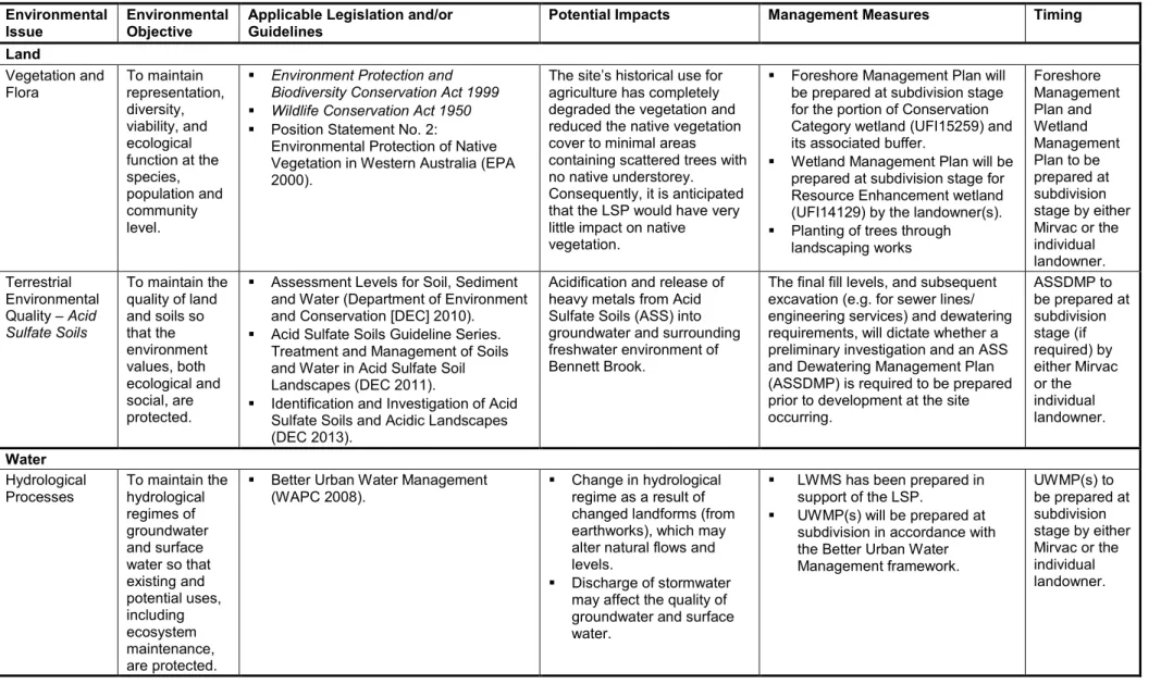
Table 1: Summary of Key Potential Environmental Impacts and Proposed Management Measures Environmental
Issue Environmental
Objective Applicable Legislation and/or
Guidelines Potential Impacts Management Measures Timing
Land
Vegetation and
Flora To maintain
representation, diversity, viability, and ecological function at the species, population and community level.
Environment Protection and Biodiversity Conservation Act 1999
Wildlife Conservation Act 1950
Position Statement No. 2:
Environmental Protection of Native Vegetation in Western Australia (EPA 2000).
The site’s historical use for agriculture has completely degraded the vegetation and reduced the native vegetation cover to minimal areas containing scattered trees with no native understorey.
Consequently, it is anticipated that the LSP would have very little impact on native vegetation.
Foreshore Management Plan will be prepared at subdivision stage for the portion of Conservation Category wetland (UFI15259) and its associated buffer.
Wetland Management Plan will be prepared at subdivision stage for Resource Enhancement wetland (UFI14129) by the landowner(s).
Planting of trees through landscaping works
Foreshore Management Plan and Wetland Management Plan to be prepared at subdivision stage by either Mirvac or the individual landowner.
Terrestrial Environmental Quality – Acid Sulfate Soils
To maintain the quality of land and soils so that the environment values, both ecological and social, are protected.
Assessment Levels for Soil, Sediment and Water (Department of Environment and Conservation [DEC] 2010).
Acid Sulfate Soils Guideline Series.
Treatment and Management of Soils and Water in Acid Sulfate Soil Landscapes (DEC 2011).
Identification and Investigation of Acid Sulfate Soils and Acidic Landscapes (DEC 2013).
Acidification and release of heavy metals from Acid Sulfate Soils (ASS) into groundwater and surrounding freshwater environment of Bennett Brook.
The final fill levels, and subsequent excavation (e.g. for sewer lines/
engineering services) and dewatering requirements, will dictate whether a preliminary investigation and an ASS and Dewatering Management Plan (ASSDMP) is required to be prepared prior to development at the site occurring.
ASSDMP to be prepared at subdivision stage (if required) by either Mirvac or the individual landowner.
Water Hydrological
Processes To maintain the hydrological regimes of groundwater and surface water so that existing and potential uses, including ecosystem maintenance, are protected.
Better Urban Water Management
(WAPC 2008). Change in hydrological
regime as a result of changed landforms (from earthworks), which may alter natural flows and levels.
Discharge of stormwater may affect the quality of groundwater and surface water.
LWMS has been prepared in support of the LSP.
UWMP(s) will be prepared at subdivision in accordance with the Better Urban Water Management framework.
UWMP(s) to be prepared at subdivision stage by either Mirvac or the individual landowner.
Environmental
Issue Environmental
Objective Applicable Legislation and/or
Guidelines Potential Impacts Management Measures Timing
Inland Water Waters Environmental Quality
To maintain the quality of groundwater and surface water, sediment and biota so that the environmental values, both ecological and social, are protected.
Bulletin 686: A Guide to Wetland Management in the Perth and Near Perth Swan Coastal Plain Area (EPA 1993).
Position Statement No 4:
Environmental Protection of Wetlands (EPA 2004a).
Draft Guideline for the Determination of Wetland Buffer Requirements (WAPC 2005).
Altered hydrological regimes.
Increased residential population in close proximity to Bennett Brook leading to loss of wetland attributes through informal / unregulated uses.
Foreshore Management Plan will be prepared at subdivision stage for the portion of Conservation Category wetland (UFI15259) and its associated buffer.
Wetland Management Plan will be prepared at subdivision stage for Resource Enhancement wetland (UFI14129) by the landowner(s).
Foreshore Management Plan and Wetland Management Plan to be prepared at subdivision stage by either Mirvac or the individual landowner.
People
Noise To ensure that impacts to amenity are reduced as low as reasonably practicable.
Environmental Protection (Noise) Regulations 1997
Environmental Assessment Guideline 13: Consideration of environmental impacts from noise (EPA 2014).
State Planning Policy (SPP) 5.4: Road and Rail Transport Noise and Freight Considerations in Land Use Planning (WAPC 2009).
Noise associated with road traffic has the potential to impact the amenity of future residential development within the site.
Implementation of Quiet House Design along Marshall Road.
Construction of a 1.8–2.0 metre high barrier and Quiet House Design along Lord Street.
Construction of a 2.0 metre high barrier and Quiet House Design along the Reid Highway.
Notification on Titles for those residences that receive a noise level that exceeds noise targets.
Incorporated into
subdivision design / constructed development.
Heritage To ensure that historical and cultural associations are not adversely affected.
Aboriginal Heritage Act 1972
Guidance Statement No. 41:
Assessment of Aboriginal Heritage (EPA 2004b).
Excavation / construction activities may unearth and/or damage artefacts or other items of cultural Aboriginal significance.
Apply for approval to disturb the Aboriginal archaeological site under Section 18 of the Aboriginal Heritage Act 1972.
Be vigilant during earthworks and stop work immediately should any items be discovered. Notify the Department of Aboriginal Affairs.
Prior to construction occurring / during construction either by Mirvac or the individual landowner(s).
Environmental
Issue Environmental
Objective Applicable Legislation and/or
Guidelines Potential Impacts Management Measures Timing
Human Health To ensure that human health is not adversely affected.
Contaminated Sites Act 2003
Department Environment Regulation Contaminated Sites Guidelines series.
The site has been historically used for agricultural practices and contains aged
infrastructure associated with agricultural land uses.
Potentially, this infrastructure may have been made from materials containing asbestos.
After the removal of the existing infrastructure from the site, the areas subject to demolition works will be remediated in accordance with the Contaminated Sites Act 2003 to be suitable for residential land uses.
Prior to subdivision.
Bushfire Risk To reduce the risk of bushfire to people, property and infrastructure.
Australian Standard 3959:2009:
Construction of Buildings in Bushfire- prone Areas (Standards Australia 2009).
Guidelines for Planning in Bushfire Prone Areas (Department of Planning and WAPC 2015a).
SPP 3.7: Planning in Bushfire Prone Areas (Department of Planning and WAPC 2015b).
The implementation of subdivisions and development within the site will result in an increased risk to people, property and infrastructure being impacted by potential bushfires in the Resource Enhancement Wetland and the Bennett Brook foreshore environments.
Implementation of the approved
Bushfire Management Plan. During construction.
TABLE OF CONTENTS
PageEXECUTIVE SUMMARY ... i
1.0 INTRODUCTION ... 1
1.1 Background ... 1
1.2 Planning Context ... 1
1.2.1 Metropolitan Region Scheme ... 1
1.2.2 Regional Planning ... 1
1.3 Purpose of this Report ... 2
1.4 Associated Reports ... 3
1.5 Abbreviations ... 3
2.0 LOCAL STRUCTURE PLAN ... 5
2.1 Description ... 5
2.1.1 Response to Environmental Protection Bulletin No. 20 ... 5
2.2 Key Environmental Influences ... 5
2.3 Land Use ... 6
2.3.1 Previous and Existing Land Uses ... 6
2.3.2 Surrounding Land Uses ... 6
3.0 LEGISLATION AND REGULATION ... 9
3.1 Legislation and Regulations ... 9
3.1.1 Applicable Guidelines and Standards ... 9
4.0 LAND-THEMED FACTORS ... 11
4.1 Vegetation and Flora ... 11
4.2 Landform ... 11
4.2.1 Topography ... 11
4.2.2 Geology ... 12
4.3 Terrestrial Environmental Quality ... 12
4.3.1 Acid Sulfate Soils ... 12
4.4 Terrestrial Fauna ... 12
4.4.1 Fauna Habitat ... 12
4.4.2 Database Searches ... 12
5.0 WATER-THEMED FACTORS ... 15 5.1 Hydrological Processes ... 15 5.1.1 Groundwater ... 15 5.1.2 Surface Water ... 15 5.2 Inland Water Environmental Quality ... 16 5.2.1 Wetlands ... 16
6.0 PEOPLE-THEMED FACTORS ... 19 6.1 Amenity ... 19
6.1.1 Noise ... 19 6.1.2 Odour ... 19 6.2 Heritage ... 20 6.2.1 Aboriginal Heritage ... 20 6.2.2 European Heritage ... 20 6.3 Human Health... 20 6.3.1 Potential Contamination ... 20 6.4 Bushfire Risk ... 21
7.0 POTENTIAL ENVIRONMENTAL IMPACTS AND
MANAGEMENT MEASURES ... 22 7.1 Introduction ... 23 7.2 Land-themed Factors ... 23
7.2.1 Flora and Vegetation ... 23 7.2.2 Terrestrial Environmental Quality – Acid Sulfate Soils ... 24 7.3 Water-themed Factors ... 25
7.3.1 Hydrological Processes ... 25 7.3.2 Inland Waters Environmental Quality ... 26 7.4 People-themed Factors ... 26
7.4.1 Noise ... 26 7.4.2 Heritage ... 27 7.4.3 Human Health ... 28 7.4.4 Bushfire Risk ... 28
8.0 MANAGEMENT COMMITMENTS AND CONCLUSIONS ... 30
9.0 REFERENCES ... 32
TABLES
(contained within report text) Page
Table 1: Summary of Key Potential Environmental Impacts and Proposed
Management Measures ... iv Table 2: Abbreviations ... 3 Table 3: Key State and Commonwealth Legislation and Regulations ... 9 Table 4: Applicable EPA Standards, Guidelines and State Planning Policies ... 9 Table 5: Wetland Management Categories and Objectives ... 16
FIGURES
(contained within report text) Page
Figure A: Bennett Brook foreshore setback ... 17
(compiled at rear of report) Figure 1: Site Location
Figure 2: Metropolitan Region Scheme Zoning Figure 3: Local Structure Plan
Figure 4: Vegetation Units and Condition Figure 5: Topography and Geology Figure 6: Acid Sulfate Soils Risk Mapping Figure 7: Potential Black Cockatoo Habitat Figure 8: Bennett Brook 100 Year ARI Flood Plain
Figure 9: Swan Coastal Plain Geomorphic Wetland Mapping and Management Buffers Figure 10: Poultry Farm Odour Buffer
Figure 11: Aboriginal Heritage Sites
PLATES
(contained within report text) Page
Plate A: Rural Lots along Coast Road ... 6 Plate B: Existing Resource Enhancement Wetland Environment ... 18
APPENDICES
APPENDIX 1: EPA Decision: Local Planning Scheme 17 – Amendment 139 APPENDIX 2: Level 1 Flora and Vegetation Survey and Significant Tree Inventory APPENDIX 3: Flora and Fauna Database Searches
APPENDIX 4: Acoustic Assessment
APPENDIX 5: Aboriginal Heritage Database Search
1.0 INTRODUCTION
1.1 Background
Mirvac has prepared a Local Structure Plan (LSP) to facilitate the development of Lots 6 and 40–46 Marshal Road, Lots 1 and 74–78 Coast Road, and Lots 29, 102, 500 and 800 Victoria Road (the site) in Bennett Springs for residential purposes.
While Mirvac has prepared this LSP, it does not have ownership of all the lots within the site. Mirvac will be responsible for developing land within its ownership; however, other individual landowners may seek to develop their land independent of Mirvac. These landowners will need to have due regard to this LSP and associated reports, e.g. this Environmental Assessment Report and Local Water Management Strategy (LWMS) in regards to any future development of their lot(s).
The 57 hectare (ha) site is located in the City of Swan (CoS) around 13 kilometres (km) east-north-east of the Perth Central Business District. The site is situated south of Marshall Road and bounded by Lord Street to the east, Reid Highway to the south and Bennett Brook to the west (Figure 1).
The site has been historically cleared for agricultural purposes it primarily consists largely of grassed paddocks devoid of native vegetation. Scattered eucalyptus and Corymbia calophylla (marri) trees are present, primarily, within Lots 45 and 46 Marshall Road and a stand of Melaleuca sp. within Lot 41 Marshall Road, is associated with a Resource Enhancement wetland.
To the west of the site lies Bennett Brook which is, included with the extent of Bush Forever Site No. 305 – Bennett Brook, Eden Hill to West Swan, and is classified as Conservation Category wetland (UFI15259) (Figure 2).
1.2 Planning Context
1.2.1 Metropolitan Region Scheme
The site is zoned “Urban” under the Metropolitan Region Scheme (MRS), with small portions allocated to “Primary Regional Roads” and “Railways” (Figure 2).
1.2.2 City of Swan Local Planning Scheme 17
The City of Swan initiated Amendment No. 139 to rezone portion of Lots 40, 41 and Lots 6, 43, 45 and 46 Marshall Road, and Lots 1, 42, 44, 74–78 Coast Road and portion of Lots 29, 500 and Lot 800 Victoria Road and portion of Lots 102 and 103 Reid Highway, Bennett Springs from “General Rural” to “Residential Development” zone.
The Environmental Protection Authority (EPA) assessed the scheme amendment and determined the environmental impacts to not be so significant as to warrant formal assessment under Part IV of the Environmental Protection Act 1986 (EP Act), providing the advice provided in Appendix 1 is implemented.
1.2.3 Regional Planning
The site is identified within the “North-East Sub-region”, which is expected to grow by 69,000 people, to a total population of 258,000. Based on a “Connected City” scenario, a growth target of 15 dwellings per gross urban zoned hectare is set by the Western Australian Planning Commission (WAPC) in Directions 2031and Beyond (WAPC 2010).
The Swan Urban Growth Corridor Sub-Regional Structure Plan (SUGCSRSP) inclusive of this site (identified as of the West Swan “West” urban cell) was adopted by the WAPC in 2009. The SUGCSRSP identifies the site as “Residential” with power line easement traversing on an east–west alignment along the northern (Marshall Road) boundary.
To support the planning of the West Swan “West” urban cell in the SUGCSRSP, and to establish the urban water management design principles, a District Water Management Strategy (DWMS) was prepared in 2011. The DWMS was sequentially approved by of the Department of Water and the City of Swan in 2015 as part of the “Lifting of Urban Deferment”.
The management objectives from the DWMS have been incorporated into the site specific LWMS supporting the LSP.
1.3 Purpose of this Report
The CoS’ LPS No. 17 requires a LSP to be prepared and endorsed by the WAPC prior to granting and/or recommending approval of any future residential subdivision and development.
The purpose of this Environmental Assessment Report (EAR) is to:
1. Address key environmental factors that may impact on future development.
2. Outline the management measures that will be adopted to mitigate any potentially significant environmental impacts from future development.
3. Facilitate the approval of the LSP with the CoS to provide a framework to coordinate residential subdivision and development.
1.4 Associated Reports
Previous reports produced for the site (and adjacent landholdings) include:
1. District Water Management Strategy, West Swan (West) (TME 2011).
2. Flood and Drainage Assessment, West Swan (West) Cell Issue No. 2. (VDM Consulting 2011).
3. Level 1 Flora and Vegetation Survey and Significant Tree Inventory, West Swan Residential Project – Lord Street and Marshall Road Precinct (RPS 2015).
4. Local Water Management Strategy, Bennett Springs East, Lord Street and Marshall Road Precinct (RPS 2016). The LWMS details the integrated water management strategies that will be implemented at the site, and demonstrates that the land is capable of facilitating urban development whilst achieving sustainable, water and environmental outcomes.
5. Acoustic Assessment, Mirvac, West Swan (Herring Storer Acoustics 2015).
6. Bushfire Management Plan, Coast Road, West Swan (Strategen 2015).
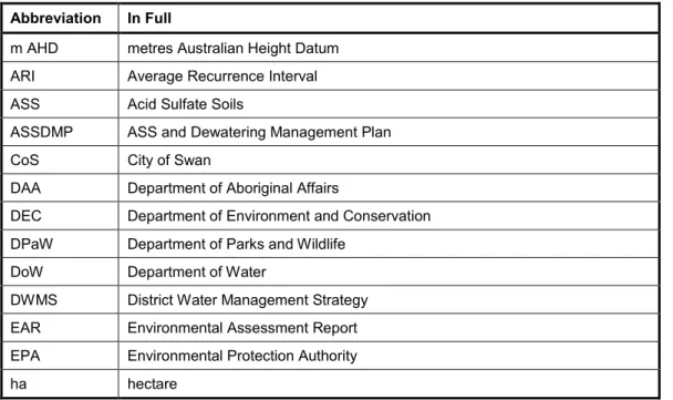
1.5 Abbreviations
Table 2 identifies the abbreviations that are used within this report for ease of reference.
Table 2: Abbreviations
Abbreviation In Full
m AHD metres Australian Height Datum ARI Average Recurrence Interval ASS Acid Sulfate Soils
ASSDMP ASS and Dewatering Management Plan
CoS City of Swan
DAA Department of Aboriginal Affairs
DEC Department of Environment and Conservation DPaW Department of Parks and Wildlife
DoW Department of Water
DWMS District Water Management Strategy EAR Environmental Assessment Report EPA Environmental Protection Authority
ha hectare
Abbreviation In Full
km kilometres
km2 square kilometres LPS Local Planning Scheme LSP Local Structure Plan
LWMS Local Water Management Strategy
m metres
mm millimetres
MRS Metropolitan Region Scheme
POS Public Open Space
SSRSP Swan Sub-Regional Structure Plan WAPC Western Australian Planning Commission
2.0 LOCAL STRUCTURE PLAN
2.1 Description
The LSP has been developed to guide the subdivision and development of approximately 57 ha of primarily undeveloped land (Figure 3) and promotes the following key land uses:
Residential
Public Open Space (POS)
Local Road
Primary Regional Road
Railway Reserve.
2.1.1 Response to Environmental Protection Bulletin No. 20
The LSP responds to the Environmental Protection Authority’s (EPA) design guidelines for planning and development, as outlined in the Environmental Protection Bulletin No.
20: Protection of natural areas through planning and development (EPA 2013):
locating proposed future development in historically cleared parts of the site
protecting the consolidated naturally vegetated areas of Bennett Brook foreshore environments, adjacent to the site, from future development
maintaining the ecological linkage along Bennett Brook connecting fauna habitat with the large naturally vegetated areas in Whiteman Park
minimising development in naturally vegetated areas to minimising the risk of fire and its potential impacts on the future residential community.
2.2 Key Environmental Influences
The key environmental influences of the LSP were:
Bennett Brook foreshore
wetland management
water quality and drainage within the Swan River catchment
management of Acid Sulfate Soils (ASS).
2.3 Land Use
2.3.1 Previous and Existing Land Uses
A review of historical aerial photography from 1953 to 2014, shows that the majority of the site has been cleared of native vegetation since 1953 (or before) and used for agricultural purposes.
The site predominantly consists largely of grassed paddocks with native trees that are predominately located with Lots 41, 45 and 46 Marshall Road.
The majority of the site is currently used as sheep and cattle grazing paddock with residential dwellings and a Cambodian Centre in the site (Plate A).
Plate A: Rural Lots along Coast Road
2.3.2 Surrounding Land Uses
The site is bound on the west by the Bennett Brook foreshore. To the south, the site is bordered by Marshall Road, to the east by Lord Street and Reid Highway to the south.
2.3.2.1 Bennett Brook and Bush Forever Site No. 305
The Bennett Brook foreshore and creek environments are included within the extent of Bush Forever Site No. 305 – Bennett Brook, Eden Hill to West Swan (Figures 1 and Figure A).
Bush Forever Site 305 – Bennett Brook, Eden Hill to West Swan, comprises 120 ha of bushland associated with seasonal and permanent wetlands. The vegetation with Bush Forever Site 305 – Bennett Brook, Eden Hill to West Swan, belongs to the broad Floristic Community Type of Supergroup 2 – S7 Northern woodlands to forests over tall sedgelands alongside permanent wetlands (WAPC 2000).
Bush Forever Site 305 – Bennett Brook, Eden Hill to West Swan, links to Bush Forever Site 304 – Whiteman Park in the north and Site 302 – Swan River and Jane Brook in the east forming part of contiguous and fragmented bushland / wetland linkage.
This page is intentionally blank.
3.0 LEGISLATION AND REGULATION
3.1 Legislation and Regulations
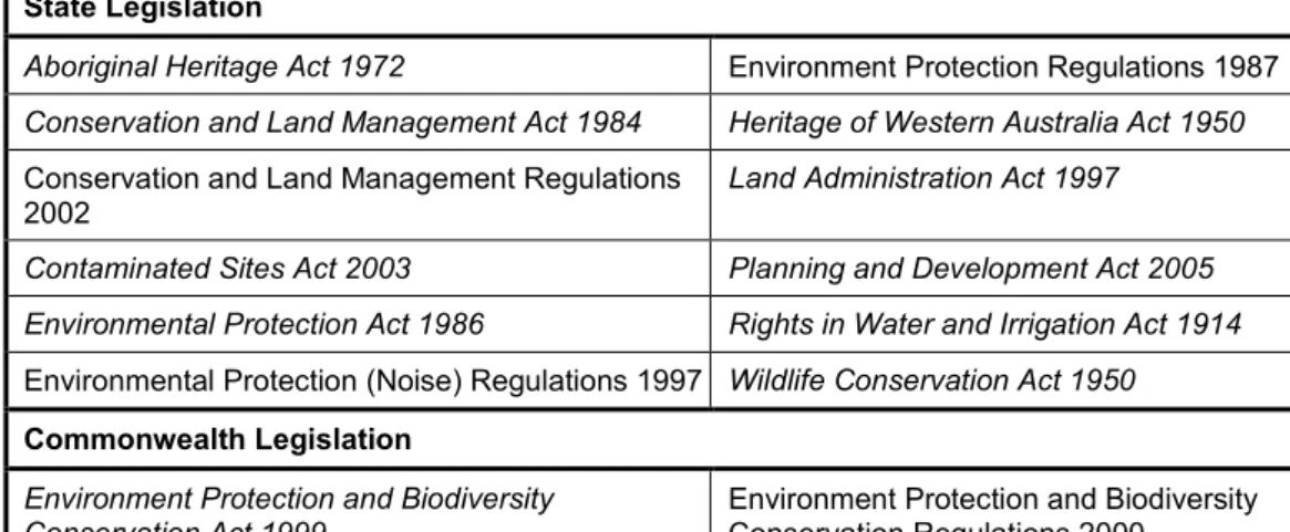
Urban development within the site is required to comply with environmental legislation and regulations. A summary of the key state and Commonwealth legislation and regulations is listed in Table 3.
Table 3: Key State and Commonwealth Legislation and Regulations State Legislation
Aboriginal Heritage Act 1972 Environment Protection Regulations 1987 Conservation and Land Management Act 1984 Heritage of Western Australia Act 1950 Conservation and Land Management Regulations
2002 Land Administration Act 1997
Contaminated Sites Act 2003 Planning and Development Act 2005 Environmental Protection Act 1986 Rights in Water and Irrigation Act 1914 Environmental Protection (Noise) Regulations 1997 Wildlife Conservation Act 1950 Commonwealth Legislation
Environment Protection and Biodiversity
Conservation Act 1999 Environment Protection and Biodiversity Conservation Regulations 2000
3.1.1 Applicable Guidelines and Standards
Development of the site is required to comply with applicable guidelines and standards developed by the EPA. These guidelines and standards assist proponents and the general public to understand the minimum requirements for the protection of elements of the environment that the EPA expects to be met during the assessment process. Table 4 details the key EPA standards, guidelines and state planning policies relevant to the site.
Table 4: Applicable EPA Standards, Guidelines and State Planning Policies
EPA Position Statements
Position Statement No. 2: Environmental Protection of Native Vegetation in Western Australia Position Statement No. 3: Terrestrial Biological Surveys as an Element of Biodiversity Protection EPA Environmental Assessment Guidelines
Environmental Assessment Guideline No. 8: Environmental factors and objectives Environmental Assessment Guideline No. 9: Application of significance framework in the environmental impact assessment process
EPA Guidance Statements
Guidance Statement No.3: Separation Distances between Industrial and Sensitive Land Uses.
Guidance Statement No. 8: Environmental Noise (Draft).
Guidance Statement No. 33: Environmental Guidelines for Planning and Development Guidance Statement No. 41: Aboriginal Heritage Assessment
Guidance Statement No. 51: Terrestrial Flora and Vegetation Surveys for Environmental Impact Assessment in Western Australia
Guidance Statement No. 56: Terrestrial Fauna Surveys for Environmental Impact Assessment in Western Australia
EPA Protection Bulletins
Environmental Protection Bulletin No. 20: Protection of naturally vegetated areas through planning and development.
State Planning Policies
State Planning Policy (SPP) 5.4: Road and Rail Transport Noise SPP No. 3.7: Planning in Bushfire Prone Areas
4.0 LAND-THEMED FACTORS
4.1 Vegetation and Flora
The site contains very limited native vegetation due to extensive clearing for agricultural purposes. The remaining native vegetation consists entirely of upper storey (trees) with a mixed exotic Closed Grassland consisting of pasture species underneath.
A small a stand of Melaleuca sp. is associated with Resource Enhancement wetland (UFI14129) within Lot 41 Marshall Road and scattered eucalyptus and Corymbia calophylla (marri) trees are also present, primarily within Lots 45 and 46 Marshall Road.
A Level 1 Flora and Vegetation Survey and Significant Tree Inventory was undertaken in 2015 by RPS for a portion of the site to inform the preparation of the LSP (Appendix 2). The survey area comprised of Lots 44, 45 and 46 within the site and the eastern foreshore environment of the Bennett Brook directly adjacent to the site.
RPS (2015) found that one Vegetation Unit occurred within Lots 44, 45 and 46, Scattered Trees over Pasture comprising of Scattered *Eucalyptus microtheca, Corymbia calophylla, *E. botryoides and E. gomphocephala over mixed exotic Closed Grassland in
“Completely Degraded” condition (Figure 4).
The foreshore environment of the Bennett Brook was assessed as comprising of four vegetation units ranging in from “Good to Very Good” to “Completely Degraded”
condition (Appendix 2).
RPS (2015) identified that no Threatened or Priority species nor Threatened or Priority Ecological Communities were recorded in the portion of the site surveyed.
Given the remainder of the site was historically cleared of its original vegetation prior to or in 1953, and predominantly consists of mixed exotic Closed Grassland consisting of pasture species with a scattering of trees, conservative significant species are not expected to be present within the landholdings.
4.2 Landform
4.2.1 Topography
The topography of the site is generally flat with a gradual decline from north to south, toward the Reid Highway. The northern boundary of the site is approximately 16 m Australian Height Datum (m AHD) at Marshall Road and gradually declines to the lowest point along the southern boundary, adjacent to Reid Highway where the topography is 12 m AHD (Figure 5).
4.2.2 Geology
Department of Industry and Resources geology mapping indicates the site is generally composed of Bassendean sands in various thicknesses overlaying Guilford Formations (DoIR 1999).
The Bassendean sands cover the majority of the site. Near Bennett Brook, the Bassendean Sands tend to occur over alluvium. Bennett Brook itself is composed of Clayey Silt (Figure 5).
4.3 Terrestrial Environmental Quality
4.3.1 Acid Sulfate Soils
Department of Environment Regulation (DER) Acid Sulfate Soils (ASS) risk mapping shows the majority of the site is unmapped / has no known risk of ASS occurring within 3 m of the natural soil surface (or deeper).
A small portion of the site, primarily adjacent to Bennett Brook, is mapped as
“Moderate to low risk of ASS occurring within 3 m of the natural soil surface” with the Bennett Brook and foreshore environments mapped as “High to moderate risk of ASS occurring within 3 m of the natural soil surface” (Figure 6).
4.4 Terrestrial Fauna
4.4.1 Fauna Habitat
Historic clearing of native vegetation has resulted in the loss of the majority of fauna habitat values from within the site. The remaining available habitat for native fauna species primarily consists of scattered trees within Lots 44, 45 and 46 and the small stand of Melaleuca sp., which may be of some value for avifauna species.
The remnant native vegetation within the Bennett Brook and foreshore environments has some habitat value for native terrestrial and avian species with the creek line potentially allowing for the lateral movement of fauna through the local Bennett Springs landscape.
4.4.2 Database Searches
Searches of DPaW’s NatureMap database and the Commonwealth Department of the Environment’s Protected Matters Search Tool were undertaken to identify species of conservation significant fauna recorded or likely to occur within a 5 km radius of the site using the search coordinates 115°57ʹ33ʺE, 31°51ʹ29ʺS (Appendix 3).
Based on ecological requirements, known distributions and the type and quality of fauna habitats, the key species that could potentially be directly impacted by future residential development of the site, include:
forest red tailed black cockatoo (Calyptorhynchus banksii naso)
Carnaby’s Black-Cockatoo (Calyptorhynchus latirostris)
Baudin’s black cockatoo (Calyptorhynchus baudinii).
Additionally, the Bennett Brook and foreshore environments may support the following conservation significant species:
southern brown bandicoot (Isoodon obesulus / Isoodon obesulus subsp. fuscinventer) (Priority 5)
water-rat (Hydromys chrysogaster) (Priority 4)
rainbow bee-eater (Merops ornatus) (Migratory).
Given the 120 ha extent of Bush Forever Site 305 – Bennett Brook, Eden Hill to West Swan, which includes the Bennett Brook and foreshore environments (Figures 1 and Figure A), and the Bush Forever Site’s direct linkages to Bush Forever Site 304 – Whiteman Park in the north and Site 302 – Swan River and Jane Brook in the east which form part of contiguous and fragmented bushland / wetland linkage, it is considered unlikely that the southern brown bandicoot, water rat or rainbow bee-eater would be significantly impacted by the proposed development (if present in the Bennett Brook and foreshore environments adjacent to the site).
4.4.2.1 Black Cockatoo Habitat
The Level 1 Flora and Vegetation Survey and Significant Tree Inventory (RPS 2015) identifies that there were five Eucalyptus gomphocephala, eight Corymbia calophylla and two Eucalyptus marginata recorded (Appendix 2).
It is considered likely that the native trees may be utilised opportunistically by black cockatoo species moving through the Bennett Springs landscape, however given that the native trees occur in a predominantly cleared landscape it is considered unlikely that the trees would be utilised on a permanent basis.
Potential black cockatoo habitat on the site comprises of approximately 0.31 ha of foraging habitat with one Eucalyptus marginata tree, within Lot 46, was identified as having hollows (Figure 7). Figure 7 indicates that approximately 0.10 ha of potential foraging habitat, and the one Eucalyptus marginata tree with hollows, is located within the 50 m buffer of Conservation Category wetland (UFI15259).
Potential black cockatoo habitat within the Conservation Category wetland’s 50 m buffer will be retained by the LSP (Figure 3). Scattered Eucalypt trees have also been retained within POS areas where possible.
The implementation of the LSP will result in the loss approximately 0.21 ha of potential foraging habitat from the site (Figure 7).
It is considered that the implementation of the LSP will not result in a significant impact, as defined under the Matters of National Environmental Significance: Significant Impact Guidelines 1.1 (Commonwealth of Australia 2013) occurring to black cockatoos.
5.0 WATER-THEMED FACTORS
5.1 Hydrological Processes
5.1.1 Groundwater
The site is located within the Swan and Mirrabooka Groundwater areas. Both are extensively allocated with some small available volumes, predominately in the superficial aquifers (TME 2011).
Groundwater levels fluctuate seasonally with the highest groundwater levels, recorded during winter, being close to the ground’s natural surface (TME 2011).
Groundwater flow through the West Swan “West” general area is eastwards from the Gnangara mound to the Swan River. There is however localised deviations from this due to the effects of other drains and waterways such as Bennett Brook. This results in groundwater moving generally through the site in a south-westerly direction towards the Bennett Brook. Groundwater level contours across the West Swan “West” general area range from 19 m AHD down to 13 m AHD (TME 2011).
5.1.1.1 Groundwater Quality
Groundwater pH below the site is likely to be generally slightly acidic. The levels of nutrients in groundwater are likely elevated above the targets of the Healthy Rivers Action, which are 0.1 mg/L total phosphorous and 1.0 mg/L total nitrogen (TME 2011).
5.1.2 Surface Water
In relation to the site, the key surface water feature is the Bennett Brook, which lies adjacent to the site’s western boundary. Bennett Brook drains a total catchment of 69 square kilometres (km2). Where Bennett Brook first borders the site its catchment is approximately 40.7 km2. The site is approximately 2.5% of the total catchment (TME 2011).
5.1.2.1 Flood Levels
TME (2011) identifies that the 100 year Average Recurrence Interval (ARI) flood fringe of the Bennett Brook extends to the 18.65 m AHD contour where Bennett Brook borders the site. The flood level drops to 10.84 m AHD along the southern boundary of the site, prior to discharging under Reid Highway. The water then drops again to 9.93 m AHD, shortly after Reid Highway (TMW 2011).
Figure 8 shows the extent of the Bennett Brook 100 year ARI flood plain in relation to the site.
5.2 Inland Water Environmental Quality
5.2.1 Wetlands
Table 5 identifies the management objectives for all the three categories of geomorphic wetland.
Table 5: Wetland Management Categories and Objectives Management
Category General
Description Management Objectives Conservation Wetlands support a
high level of ecological attributes and functions
Highest priority wetlands. Objective is preservation of wetland attributes and functions through various mechanisms including:
reservation in national parks, Crown reserves and state-owned land
protection under Environmental Protection Policies
wetland covenanting by landowners.
These are the most valuable wetlands and the Commission will oppose any activity that may lead to the further loss or degradation. No development.
Resource
Enhancement Wetlands which may have been partially modified but still support substantial
ecological attributes and functions
Priority wetlands. Ultimate objective is for management, restoration and protection towards improving their conservation value. These wetlands have the potential to be restored to conservation category. This can be achieved by restoring wetland structure, function and biodiversity. Protection is recommended through a number of mechanisms.
Multiple Use Wetlands with few important ecological attributes and functions remaining
Use, development and management should be considered in the context of ecologically sustainable development and best management practice catchment planning through land care. Should be considered in strategic planning.
Source: Water and River Commission 2001
5.2.1.1 Swan Coastal Plain Geomorphic Wetland Mapping
Figure 9 presents the current Swan Coastal Plain geomorphic wetland mapping for the site and the buffer requirements for the Conservation Category and Resource Enhancement wetlands.
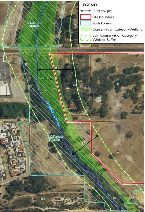
Conservation Category Wetland
The mapped Conservation Category wetland (UFI15259) is located within the Bennett Brook and foreshore (Figure A).
Figure A: Bennett Brook Foreshore Setback
Figure A illustrates that the Bennett Brook watercourse and the Conservation Category wetland (UFI15259) are not correctly aligned. The LSP has accommodated over a 100 m buffer from the Bennett Creek and 50 m buffer from the mapped Conservation Category wetland boundary (Figure A and Figure 9).
Resource Enhancement Wetland
Located within Lot 41 Marshall Road the Resource Enhancement wetland (UFI14129) consists of a stand of Melaleuca sp. with a mixed exotic Closed Grassland consisting of pasture species underneath (Plate B).
The Resource Enhancement wetland is currently utilised for agricultural purposes (e.g.
sheep paddock).
Plate B: Existing Resource Enhancement Wetland Environment
6.0 PEOPLE-THEMED FACTORS
6.1 Amenity
6.1.1 Noise
Figure 2 identifies that land holdings abutting Reid Highway, to the south of the site.
Additionally, the Reid Highway and Lord Street, which lie adjacent to the site in the south and east, respectively, are both reserved under the MRS as “Primary Regional Roads”.
An Acoustic Assessment was undertaken in 2015 by Herring Storer Acoustics for the site to determine the extent to which potential noise impacts received from road traffic would impact future residential development (Appendix 4).
Herring Storer Acoustics (2015) determined that without any noise amelioration, noise received at the majority of future residences located adjacent to the roads would exceed the noise targets, as set out in SPP 5.4: Road and Rail Transport Noise and Freight Considerations in Land Use Planning.
Herring Storer Acoustics (2015) recommended the following measures to address the identified road traffic noise:
implementation of Quiet House Design along Marshall Road
construction of a 1.8–2.0 metre high barrier and Quiet House Design along Lord Street
construction of a 2.0 metre high barrier and Quiet House Design along the Reid Highway
notification on Titles for those residences that receive a noise level that exceeds noise targets.
6.1.2 Odour
A poultry farm is located approximately 530 m north of the site on Lot 60 Cheltenham Street, Bennett Springs.
Figure 10 shows the extent of the 500 m buffer in relation to the site and demonstrates that the site is not located within the poultry farm buffer. This buffer distance is consistent with the EPA’s draft separation distances between industrial and sensitive land uses (EPA 2015).
It is also noted there is an approved subdivision approximately 520 m east of the poultry farm.
6.2 Heritage
6.2.1 Aboriginal Heritage
A search of the Department of Aboriginal Affairs (DAA) Aboriginal Heritage Inquiry System database was undertaken on 20 July 2015 and identified that the following three Registered Sites intersect or overlay the site whilst Other Heritage Place (West Swan Isolated Artefacts; Site ID: 22643) lies within the site (Figure 11; Appendix 5):
Bennett Brook: in toto (Site ID: 3692)
Marshalls Paddock (Site ID: 3744)
Bennett Brook: Camp Area (Site ID: 3840).
An ethnographic consultant has been engaged to undertake a section 18 application and engagement with the Traditional Owners in accordance with the Aboriginal Heritage Act 1971.
6.2.2 European Heritage
A search of the Heritage Council’s inHerit database and the City of Swan’s Municipal Inventory was undertaken on 20 July 2015 and no matches were recorded for the site.
6.3 Human Health
6.3.1 Potential Contamination
A search of the DER’s Contaminated Sites database was undertaken on 20 July 2015 and no recorded contaminated site was identified for the LSP site.
The site has been historically used for agricultural practices and contains aged infrastructure associated with agricultural land uses. Potentially, this infrastructure may have been made from materials containing asbestos.
After the removal of the existing infrastructure from the site, the areas subject to demolition works will be remediated in accordance with the Contaminated Sites Act 2003 to be suitable for residential land uses.
6.4 Bushfire Risk
A Bushfire Management Plan has been prepared by Strategen to manage the potential bushfire risk posed by vegetation within, and adjacent, to the site through the implementation of a raft of mitigation measures.
The vegetation assessed by Strategen (2015) primarily consists of the stand of Melaleuca sp. with a mixed exotic Closed Grassland extent associated with the Resource Enhancement wetland within the site and the four vegetation units that comprise the Bennett Brook foreshore environment adjacent to the site. The vegetation associated with the mapped extent of the Resource Enhancement wetland and the foreshore vegetation of Bennett Brook present permanent bushfire hazard considerations.
Strategen (2015) classified the bushfire hazard presented by these vegetation extents in accordance with Guidelines for Planning for Bushfire Prone Areas (Department of Planning and WAPC 2015a), SPP 3.7: Planning in Bushfire Prone Areas (Department of Planning and WAPC 2015b) and Australian Standard 3959:2009: Construction of Buildings in Bushfire-prone Areas (Standards Australia 2009). Bushfire hazard ratings, based on the vegetation classifications, were used to inform the Bushfire Attack Level assessment and subsequently define the necessary responses for future development within the LSP.
Strategen (2015) concluded that the LSP is expected to meet the stated objectives of SPP 3.7: Planning in Bushfire Prone Areas (Department of Planning and WAPC 2015b).
This page is intentionally blank.
7.0 POTENTIAL ENVIRONMENTAL IMPACTS AND MANAGEMENT MEASURES
7.1 Introduction
This section details potential environmental impacts and proposes management measures to address the identified impact. Each environmental factor is addressed in the same format, using a series of four sub-headings as follows.
Environmental Objective – States the EPA’s objective for the identified environmental factor in accordance with Environmental Assessment Guideline No. 8: Environmental factors and objectives (EPA 2013).
Applicable Guidelines, Standards and Policies – The environmental factor is placed in context of the appropriate policy framework.
Potential Impacts – Describes the identified potential environmental impacts that might arise from the proposed development. This may take the form of impacts of the development on the environment, or constraints the environment might represent to successfully realise the project.
Management Response – Details proposed environmental management responses to address the potential impacts.
7.2 Land-themed Factors
7.2.1 Flora and Vegetation
7.2.1.1 Environmental Objective
To maintain representation, diversity, viability, and ecological function at the species, population and community level.
7.2.1.2 Applicable Guidelines, Standards and Policies
Environment Protection and Biodiversity Conservation Act 1999
Wildlife Conservation Act 1950
Position Statement No. 2: Environmental Protection of Native Vegetation in Western Australia (EPA 2000).
7.2.1.3 Potential Impacts
The site’s historical use for agriculture has completely degraded the vegetation and reduced the native vegetation cover to minimal areas containing scattered trees with no native understorey. Consequently, it is anticipated that the LSP would have very little impact on native vegetation.
7.2.1.4 Management Response
The following management measures have been developed and incorporated into the LSP to reduce the likelihood of impacts to vegetation and flora:
portion of Conservation Category wetland and its associated buffer within the site, and the Resource Enhancement wetland and its associated buffer to be managed in accordance with a Foreshore Management Plan and Wetland Management Plan, respectively
placement of POS on Lot 44 to retain as many trees as possible
planting trees / vegetation as part of the development’s landscaping works.
7.2.2 Terrestrial Environmental Quality – Acid Sulfate Soils
7.2.2.1 Environmental Objective
To maintain the quality of land and soils so that the environment values, both ecological and social, are protected.
7.2.2.2 Applicable Guidelines, Standards and Policies
Assessment Levels for Soil, Sediment and Water (Department of Environment and Conservation [DEC] 2010)
Acid Sulfate Soils Guideline Series. Treatment and Management of Soils and Water in Acid Sulfate Soil Landscapes (DEC 2011)
Identification and Investigation of Acid Sulfate Soils and Acidic Landscapes (DEC 2013).
7.2.2.3 Potential Impacts
ASS soils are stable when left undisturbed, but when they are exposed to air, during excavation or dewatering, this can set off a reaction resulting in acidity (sulfuric acid) being produced.