Outdoor Signs and Advertising
- Scope of Section
- Traffic Signs on Roads
- Permitted Activities (Traffic Signs on Roads)
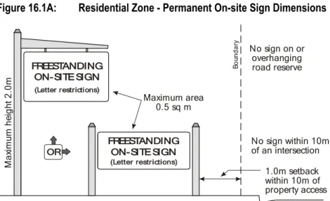
- Outdoor Signs in Residential Zone
- Permitted Activities (Outdoor Signs in Residential Zone)
- Discretionary Activities (Outdoor Signs in Residential Zone)
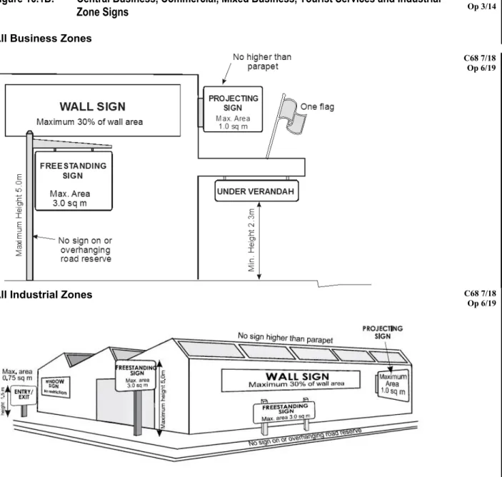
- Outdoor Signs in Business and Industrial Zones
- Permitted Activities (Outdoor Signs in Central Business, Commercial, Mixed Business, Tourist
- Restricted Discretionary Activities (Outdoor Signs in Central Business, Commercial, Mixed
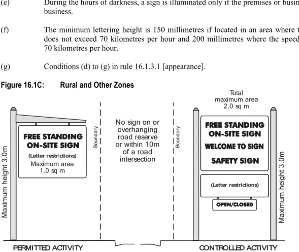
- Outdoor Signs in the Rural 1, Rural 2, Rural 3, Rural
- Permitted Activities (Outdoor Signs in Rural 1, Rural 2, Rural 3, Rural Residential,
- A Permitted Activities (Outdoor Signs for Public Purposes in Conservation, recreation, and Open
- Controlled Activities (Outdoor Signs in Rural 1, Rural 2, Rural 3, Rural Residential,
- Controlled Activities (Outdoor Signs in Rural 1, Rural 2, Rural 3, Rural Residential,
- Restricted Discretionary Activities (Outdoor Signs in Rural 1, Rural 2, Rural 3, Rural
- Temporary Signs in All Zones
- Permitted Activities (Temporary Signs)
- Restricted Discretionary Activities (Temporary Signs)
- Principal Reasons for Rules
Erecting an outdoor sign in the Residential Zone that does not comply with the permitted conditions of rule 16.1.3.1 is a free activity, if it meets the following condition:. a). Operative Chapter 16 – General Rules September 16 Permitted Activities (Exterior Signs in Rural 1, Rural 2, Rural 3, Rural Residential, Conservation, Recreation, Open Space and Papakainga Areas) Open Space and Areas Papakainga).
Transport (Access, Parking and Traffic)
Scope of Section
Land Use
- Permitted Activities (Land Use – Vehicle Access Considerations)
- Permitted Activities (Land Use – Traffic)
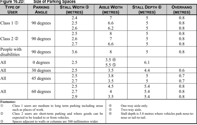
- Permitted Activities (Land Use – Provision for Parking and Loading)
- Controlled Activities (Land Use - Carparking Layout and Landscape Design in Mapua Public
- Controlled Activities (Land Use – Transport Depots)
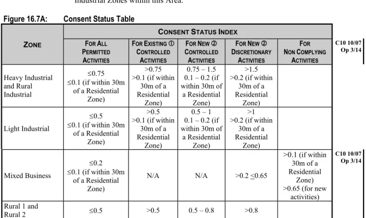
- Restricted Discretionary Activities (Land Use - General)
Any stormwater drainage feature that forms part of the stormwater drainage network is physically and legally protected from future development that may adversely affect the efficient functioning of the network. Permission can be refused, or conditions imposed, only in respect of the following matters to which the Council has limited its discretion:.
Principal Reasons for Rules
Example of Parking Layout
In the bigger and busier places of the district, the municipality provides public parking lots with the help of financial contributions. This protects the safety and efficiency of the frontage road by reducing the blocking of traffic lanes and pedestrian crossings.
Bicycle Racks
Subdivision
- Scope of Section
- All Zones
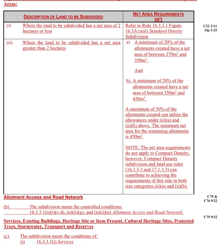
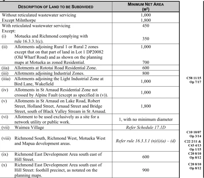
- No Permitted Subdivision (All Zones)
- Subdivision in the Slope Instability Risk Area
- Subdivision in the Fault Rupture Risk Area
- Subdivision of Hazardous Activity and Industry List Land
- Subdivision in any Zone Subject to Deferred Zone Rules, or Where Deferred Zoning Has Been
- Residential Zone
- Controlled Subdivision (Residential Zone — Standard Density Development)
- A Controlled Subdivision (Residential Zone – Specific Location: Richmond Intensive Development
- B Controlled Subdivision (Residential Zone – Specific Location: Brightwater & Wakefield
- Restricted Discretionary Subdivision (Residential Zone – Listed Cultural Heritage Site)
- A Restricted Discretionary Subdivision (Residential Zone - Standard Density Development)
- B Restricted Discretionary Subdivision (Residential Zone — Specific Location: Richmond
- C Restricted Discretionary Subdivision (Residential Zone — Specific Location: Brightwater &
- Restricted Discretionary Subdivision (Residential Zone – Compact Density Specific Locations)
- Discretionary Subdivision (Residential Zone)
- Discretionary Subdivision (Residential Zone – Specific Location)
- Discretionary Subdivision (Residential Closed Zone)
- Non-Complying Subdivision (Residential Zone)]
- Prohibited Subdivision (Residential Closed Zone)
- Prohibited Subdivision (Residential Coastal Zone at Tahi or Iwa Street, Mapua)
- Business and Industrial Zones
- Controlled Subdivision (Business and Industrial Zones)
- Restricted Discretionary Subdivision (Business and Industrial Zones – Richmond West
- A Restricted Discretionary Subdivision (Industrial Zones – Specified sites at Brightwater)Error! Bookmark not defined
- A Discretionary Subdivision (Heavy Industrial Closed Zone – Wakefield)
- Non-Complying Subdivision (Tourist Services Zone - Mapua)
- Prohibited Subdivision (Heavy Industrial Closed Zone – Wakefield)
- Rural 1 Zone
- Controlled Subdivision (Rural 1 and Rural 1 Coastal Zones)
- Restricted Discretionary Subdivision (Rural 1 Zone – Richmond West Development Area)
- Restricted Discretionary Subdivision (Rural 1 Zone – Listed Cultural Heritage Site)
- A Restricted Discretionary Subdivision (Rural 1 Zone)..................................Error! Bookmark not defined
- A Non-Complying Subdivision
- Prohibited Subdivision (Rural 1 Closed and Rural 1 Coastal Zones)
- Rural 2 Zone
- Controlled Subdivision (Rural 2 Zone)
- Restricted Discretionary Subdivision (Rural 2 Zone – Richmond West Development Area)
- Restricted Discretionary Subdivision (Rural 2 Zone – Listed Cultural Heritage Site)
- A Restricted Discretionary Subdivision (Rural 2 Zone)
- Discretionary Subdivision (Rural 2 Zone)
- A Discretionary Subdivision (Rural 2 Zone – Cooperative Living)
- Discretionary Subdivision (Rural 2 Closed Zone)
- A Non-Complying Subdivision
- Prohibited Subdivision (Rural 2 Closed Zone)
- Rural 3 Zone
- Controlled Subdivision (Rural 3 Zone)
- Restricted Discretionary Subdivision (Rural 3 Zone)
- Restricted Discretionary Subdivision (Rural 3 Zone) [16.3.9D Proposed]
- Discretionary Subdivision (Rural 3 Zone)
- Non-Complying Subdivision (Rural 3 Zone)
- Rural Residential and Closed Zones
- Controlled Subdivision (Rural Residential Zone)
- Restricted Discretionary Subdivision (Rural Residential Zone – Listed Cultural Heritage Site)
- Restricted Discretionary Subdivision (Rural Residential Zone – Specified Location)
- Restricted Discretionary Subdivision (Rural Residential Zone – Specified Locations)
- A Restricted Discretionary Subdivision (Rural Residential Zone)
- B Discretionary Subdivision (Rural Residential Zone – Cooperative Living)
- Discretionary Subdivision (Rural Residential Zone)
- Discretionary Subdivision (Rural Residential Closed Zone)
- Prohibited Subdivision (Rural Residential Closed Zone)
- All Other Zones
- Discretionary Subdivision (Other Zones)
- Principal Reasons for Rules
Subdivision in Rural Zone 1 that does not comply with controlled condition (o) of rule 16.3.5.1 is a limited discretionary activity. Subdivision in Rural Zone 1 that does not comply with conditions (p) or (q) of rule 16.3.5.1 is a limited discretionary activity. Subdivision in Rural Zone 2 that does not comply with controlled condition (m) of rule 16.3.6.1 is a limited discretionary activity.
Subdivision in the Rural 2 zone that does not comply with condition (n) or (o) of rule 16.3.6.1 is a limited discretionary activity. Subdivision in the Rural 3 zone that does not comply with condition (k) of rule 16.3.7.1 is a limited discretionary activity. Subdivision in the Rural Residential Zone that does not comply with condition (k) of rule 16.3.8.1 is a limited discretionary activity.
A subdivision in a rural residential area that does not comply with condition (a) of rule 16.3.8.1 is a limited discretionary activity.
Assessment Criteria for Subdivision
The extent to which access to support structures for emergency, maintenance and modernization purposes is maintained. ii) The extent to which the subdivision would limit the ongoing operational needs of the National Grid. The extent to which all rainwater drainage facilities that are part of the rainwater drainage network are physically and legally protected against future developments that could negatively affect the efficient operation of the network. ii) The extent to which changes in land cover have been taken into account in the design of the subdivision; and the proposed measures to avoid, remedy or mitigate the effects of those changes on stormwater flows and water quality. iii). Attention to existing and reasonably expected future changes in land use within the catchment area of the subdivision. vi).
The extent to which the design of the stormwater management network takes into account any possible future changes in development that may have an effect on or be affected by the development. vii). In the event of any change to the indicative road positions shown on the planning maps, whether the change will maintain the ability to achieve the desired connectivity (to both the transport and reserve network), resilience, drainage and access requirements of the future road network.
Transport Conditions
Services Required on Subdivision in Certain Zones
Esplanade Reserves, Strips and Access Strips
- Scope of Section
- Esplanade Reserves, Strips and Access Strips on Subdivision
- Restricted Discretionary Subdivision (Esplanade Reserves, Strips and Access Strips on
- Restricted Discretionary Subdivision (Esplanade Reserves, Strips and Access Strips on
- Principal Reasons for Rules
The general provision of the law is that when an area of less than 4 hectares is created adjacent to the water bodies listed above, a shelter reserve of 20 meters in width must be provided. Where an allotment is 4 hectares or more, the Act provides that a planning rule may require that a esplanade reserve or strip be set aside, and that a resource consent may remove or vary the width of the esplanade reserve or strip. Consent may be refused, or conditions imposed, only in relation to the following matters for which the Council has limited discretion:
Values that contribute to natural character include the natural function of the water body, aquatic and adjacent habitats, and water quality. The Act gives the Council the right to take an esplanade reserve of up to 20 meters in width when land adjacent to the sea or major rivers and lakes in the district is subdivided into allotments of less than 4 hectares.
Financial Contributions
- Scope of Section
- Financial Contributions
- Circumstances where Financial Contributions will be Imposed
- Purpose of Financial Contributions
- How Financial Contributions have been Set
- Financial Contribution on Subdivision
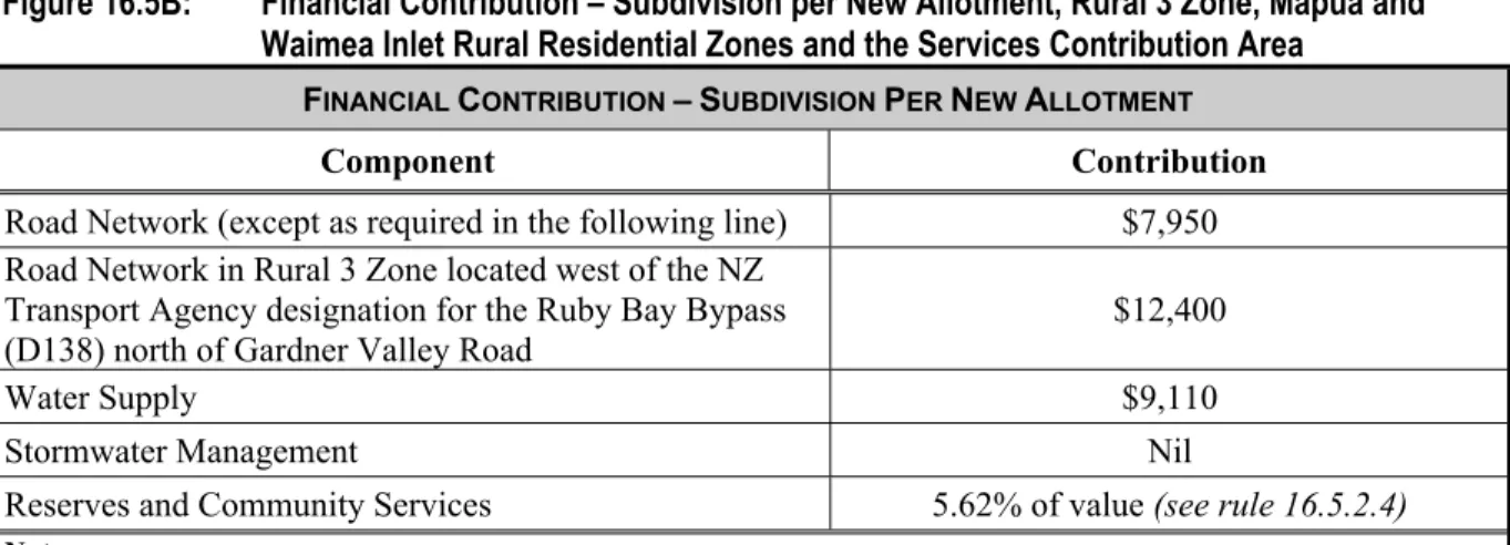
- Calculation of Financial Contribution on Subdivision (Except for Rural 3, Mapua and Waimea
- Financial Contributions on Subdivision in Rural 3, Mapua and Waimea Inlet Rural Residential
- Reductions, Waivers and Offsets of Financial Contribution on Subdivision (Except for Rural 3
- Reserves and Community Services Component of Financial Contribution on Subdivision
- Non-Complying Activities (Reductions, Waivers and Offsets of Financial Contributions on
- Financial Contributions for New Plantation Forestry
- Financial Contribution Terms for Establishment of New Plantation Forestry
- Financial Contribution on Building Development
- Permitted Activities (Financial Contribution on Building Development)
- Resource Consents (Financial Contribution on Building Development)
- Calculation of Financial Contribution on Development
- Reductions, Waivers and Offsets of Financial Contribution on Building Development
- Financial Contributions on Building Development in the Rural 3 Zone, Mapua and Waimea Inlet
- Non-Complying Activities (Reductions, Waivers and Offsets of Financial Contributions on
- Requirement for Financial Contribution on Resource Consent (Other than for Subdivision or
- Financial Contribution (Limitations)
- Financial Contribution (Limitations)
- Principal Reasons for Rules
Operational Chapter 16 - General Rules 14 July Financial Contributions for Distribution in Rural Residential Areas Rural 3, Mapua and Waimea Inlet and Service Contribution Area Service Contribution Area. Subject to subsection 16.5.1, for each allotment created by a subdivision in the Rural 3 zone, the Mapua and Waimea Inlet Rural Residential zones and the service contribution area shown on the planning maps, there shall be reduced:. Operational Division 16.5 - Financial Contributions July 14 Reductions, waivers and equalization of financial contributions on division (except for Rural 3 Zone, including Rural 3 Closed Zone, Mapua and Waimea Inlet Rural Residential Areas and Service Contribution Area) Rural 3 Closed Area, Mapua and Waimea Inlet Rural Residential Zones and Service Contribution Area).
Operating Chapter 16 – General Rules 19 December Reductions, waivers and offsets of financial contribution on building development. Operations Section 16.5 - Financial Contributions 14 July Non-compliant activities (reductions, waivers and offsets of financial contributions at construction.
Network Utilities and Public Works
- Scope of Section
- Network Utilities and Public Works
- Permitted Activities (Network Utilities and Public Works)
- Permitted Activities (Aviation and Marine Navigational Aids)
- Restricted Discretionary Activities (Slimline, Self-Supporting Masts and Poles and Attached
- Discretionary Activities (Network Utilities, Public Works, and Aviation and Marine Navigational
- Principal Reasons for Rules
Operating Chapter 16 – General Rules 16 September Permitted activities (network utilities and public works). f) The activity is not a waste transfer station, landfill, airport or land-based waste water disposal area or oxidation pond. g). The placement, operation and maintenance of an aeronautical navigation aid or beacon, or marine navigation aid or beacon, is a permitted activity that can be undertaken without a resource consent, if it meets the following conditions:. a) The navigational aid or beacon is installed for and on behalf of Maritime New Zealand and Airways New Zealand, or the Council, to mark a navigational hazard or for air navigation purposes. The size and visual appearance of network utilities and public works structures can adversely affect the quality of the landscape if they are not carefully located.
The rules regulate the visual effects of overhead lines, towers, satellite dishes, masts and other structures, depending on the sensitivity of the environment within certain zones. There are limited placement options for marine navigational aids and beacons to fulfill their function of warning of the presence of natural hazards to navigation.
Assessment Criteria – Network Utilities and Public Works
Hazardous Substances
- Scope of Section
- Hazardous Facilities
- Permitted Activities (Hazardous Facilities)
- Controlled Activities (Hazardous Facilities)
- Restricted Discretionary Activities (Hazardous Facilities)
- Non-complying Activities (Hazardous Facilities)
- Radioactive Material
- Prohibited Activities (Radioactive Material Generation, Transport, Storage and Use)
- Principal Reasons for Rules
For underground storage tanks existing before May 25, 1996 for the storage of:. i) more than 5,000 liters of petroleum products in areas outside the danger zone from the pollution of water bodies and. ii) up to 5000 liters of oil products in the areas within the danger zone from the pollution of water bodies are applied as follows:. a) the tank and its piping shall be leak tested to determine whether the pipe or tank has a leak or maintains its integrity by a person qualified and suitably experienced in leak testing or:. at intervals of at least every five years; or. where stock reconciliation shows stock losses over three consecutive draws; or. whichever is smaller, and;. Note: Underground storage tanks older than 25 years are considered unsafe. f) The dangerous object is designed, built and operated in a way that prevents: i) unintentional release of dangerous substance; and. ii) the accumulation of any liquid or solid spills or fugitive vapors or gases in closed areas, which may adversely affect the environment. g). Adherence to relevant Codes of Practice such as: i) Code of Practice for the Management of Agro-Chemicals NZS8409:1999 (or latest edition); ii) Code of Practice for the Design, Installation and Operation of Underground Petroleum Storage Systems (OSH 1992, or later versions); iii) Environmental Guidelines for Water Discharges from Petroleum Industry Sites in New Zealand (MfE 1998 or later versions); v) for LPG storage, New Zealand and Australian AS standard or later versions).
Adherence to relevant codes of practice such as:. i) the Code of Practice for the Management of Agricultural Chemicals NZS or more recent edition);. ii) the code of practice for the design, installation and operation of underground petroleum storage systems (OSH 1992, or subsequent versions);. iii) the environmental guidelines for water discharge from petroleum industrial sites in New Zealand (MfE 1998 or subsequent versions);. v) for the storage of LPG, the New Zealand and Australian Standard AS or subsequent versions);. No resource permission will be granted for the following prohibited activities:. a) The generation of radioactive material.
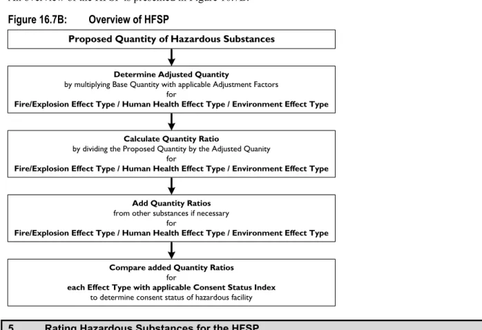
Calculation of Cumulative Quantity Ratios
Temporary Activities and Relocated Dwellings Buildings
- Scope of Section
- Temporary Activities
- Permitted Activities (Temporary Activities)
- A Permitted Activities (Temporary Activities that are Construction, Maintenance, or Demolition
- Permitted Activities (Temporary Military Training Activities)
- Controlled Activities (Temporary Military Training Activities)
- Relocation of Dwellings Buildings
- Controlled Permitted Activities (Relocation of Dwellings Buildings)
- Discretionary Activities (Relocation of Dwellings)
- Principal Reasons for Rules
The activity complies with the transport rules stated in paragraph 16.2. c) The Council's Environment and Planning Manager will be notified before the start of the project. Any temporary buildings or structures used will be removed at the end of the activity. A description of the location and activity, including times, dates, nature and location of the proposed training activities.
A building consent application for a new site or a new site within the current site is accompanied by a report identifying any restoration work that needs to be completed to the exterior of the building. Note: Building Act and New Zealand Building Code requirements also apply.
Flood Hazards
- Scope of Section
- Land Use
- Permitted Activities (Land Use)
- Restricted Discretionary Activities (Land Use)
- Buildings, Berm Lands, Stopbanks
- Prohibited Activities (Buildings, Berm Lands, Stopbanks)
- Principal Reasons for Rules
Construction or relocation of any habitable building having a floor area of more than 10 square meters within:. i) 20 meters of the landward part of any barrier bank, the top of which is more than 1 meter higher than the immediately adjacent land; or ii) 50 meters of the landward part of any lock bank, the top of which is more than 2 meters higher than the immediately adjacent land. The rules allow for small-scale storage of the kind that might be required on a farm or roadside aggregate dump or as part of river control activities, but should ensure that larger-scale activities are given due consideration of adverse effects on others before they begin. 0.02 hectare is more than 14 meters by 14 meters and is therefore a considerable area). The ban ensures that berms are away from major obstructions, that incipient dam failures can be detected and attended to, and that substantial structures are away from the most dangerous locations.
Controlling the type of fencing on roadside land helps to ensure that flood flows on roadside land are not significantly impeded. The inclusion of livestock grazing or the excavation or removal of any portion of a stop bank is intended to prevent damage to an important public asset and the potential for catastrophic failure of that asset.
Airport Protection
- Scope of Section
- All Zones
- Permitted Activities (All Zones)
- Restricted Discretionary Activities (All Zones)
- Principal Reasons for Rules
Areas to which Height Control Provisions Apply – Motueka Airport
Areas to which Height Control Provisions Apply – Takaka Airport
Bore Construction or Alteration
- Scope of Section
- Bore Construction or Alteration
- Permitted Activities (Bore Construction or Alteration)
- Controlled Activities (Bore Construction or Alteration)
- Restricted Discretionary Activities (Bore Construction or Alteration)
- Non-Complying Activities (Bore Construction or Alteration)
- Principal Reasons for Rules
The bore has not been drilled. f) The borehole is not within 20 meters of any domestic sewage treatment and disposal system. g). The borehole is not in the coastal margin of the Hau plain or delta zones or in the coastal margin of the Marahau zone. h). The borehole is not in the coastal margin of the Hau plain or delta zones or in the Marahau zone.
The borehole is not within any floodplain of any river. f) The borehole is not within 20 meters of any domestic sewage treatment and disposal system. Construction or alteration of a well that does not comply with the limited discretionary conditions of rule 16.12.2.3 is a non-conforming activity.
Historic Heritage
- Scope of Section
- Minor Repair or Addition to Heritage Building or Structure
- Permitted Activities (Minor Repair to Heritage Building or Structure)
- Restricted Discretionary Activities (Minor Repair or Addition to Heritage Building or Structure)
- Destruction or Removal of Heritage Building or Structure
- Restricted Discretionary Activities (Destruction or Removal of Heritage Building or Structure)
- Non-Complying Activities (Destruction or Removal of Heritage Building or Structure)
- Trimming or Pruning of Protected Tree
- Permitted Activities (Trimming of Protected Tree)
- Controlled Activities (Pruning of Protected Tree)
- Destruction or Removal of Protected TreeError! Bookmark not defined
- Cultural Heritage Sites
- Permitted Activities (Land Use)
- Controlled Activities (Land Use)
- Restricted Discretionary Activities (Land Use)
- Principal Reasons for Rules
The destruction or removal of any listed 16.13A Category II heritage building or structure is a limited discretionary activity. The destruction or removal of any Category 1 heritage building or structure in Schedule 16.13A is a non-compliant activity. The trimming and pruning of any protected tree listed in Schedule 16.13B is a controlled activity if it meets the following conditions: a).
Destruction or removal of any category B or C protected tree listed in Schedule 16.13B is a limited discretionary activity. There is no listed cultural heritage site or area as listed in Schedule 16.13C present on any part of the land.
Heritage Buildings and Structures
Protected Trees
Cultural Heritage Sites
Criteria for the Assessment of Significance