Premise Details
Occupier of Premises
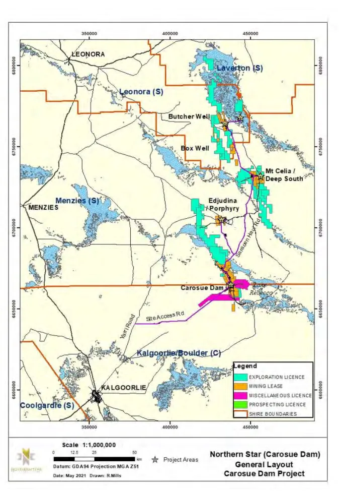
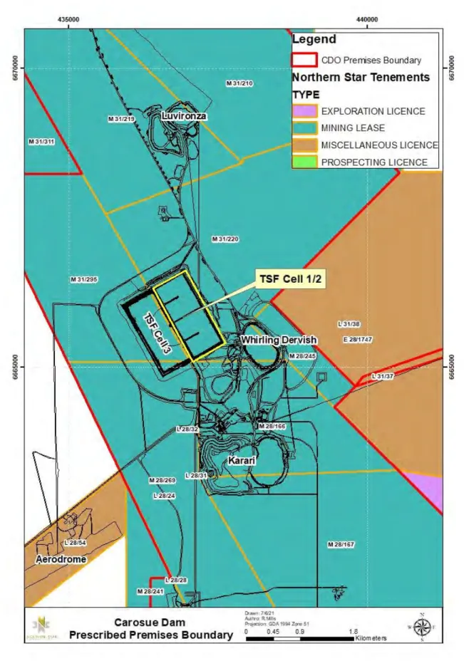
Location of Premises
Prescribed Premises Category
History
Current Operations
Construction of the TSF Cell 1/2 Phase 8 lift will take approximately 3 months to complete from approval date. Additional monitoring infrastructure (settlement pens) will be constructed to ensure the safe operation of the containment facility. No significant changes are proposed to the overall water circuit as part of the TSF Cell 1/2 Phase 8 lift.
CDHY18 drilled 1.5 km east of the existing TSF did not cross water (drilled to 60 m). From here, groundwater flows northward toward the Tana Palaeo Channel toward Lake Rebecca. Groundwater in the TSF area has been altered by the construction and operation of the existing TSF and by the dewatering and mining of the Whirling Dervish open pit mine.
The Carosue Dam area lies in the south-eastern corner of the Murchison 1 (MUR1 – East Murchison) IBRA sub-region. The nearest supply water point is Relief Hill Well (not in use) located 5.5km east of the TSF. The TSF will continue to be inspected for evidence of exposure to fauna or trapping; any animals seen in the vicinity of the TSF will be discouraged or removed.
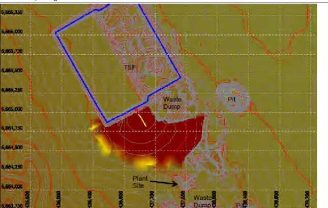
Lake Rebecca lies approximately 8 km north-east of the TSF and surface water flows into Lake Rebecca.
DESCRIPTION OF ACTIVITY
Outline of Proposed Activity
Construction and Operation of Cell 1/2 Stage 8 Embankment
Nature of Discharges
Dust
A Priority 3 Species Eremophila arachnoides is known in the local area, with the closest individuals present some 500 meters northwest of the facility. The use of the existing TSF and the Whirling Dervish dewatering have not impacted Relief Hill Well. Lake Rebecca is approximately 8 km northeast of the TSF and surface and groundwater flows into Lake Rebecca (Figure 6 & Figure 7).
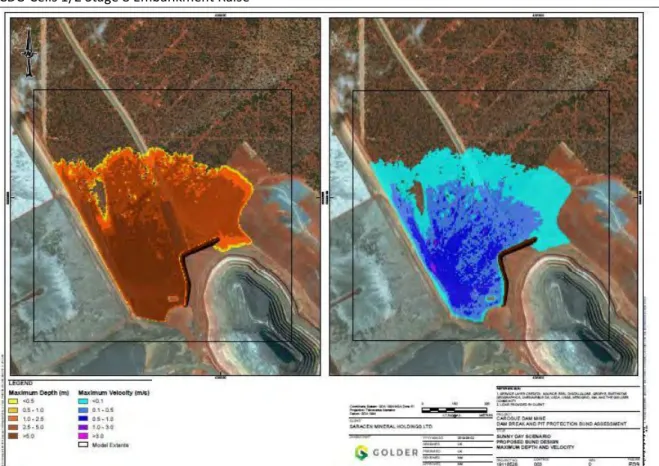
Effects of surface water and/or groundwater movement to Lake Rebecca are therefore not expected from the expansion of the TSF extension. Knight Piésold conducted an initial dam breach study as part of the cell 3 design. An evaluation was completed of the suitability of the dam breach barrier existing between the Whirling Dervish Pit (and operational underground mine) and TSF Cell 1 (as this one is the only cell from which a dam breach scenario could affect the underground mine).
The plan is incorporated into the Landfill Operations Manual which will be revised in parallel with the construction of the Phase 8 lift of Cells 1 and 2. The nearest irrigation facility is the Relief Hill well located 5.5 km east of the existing TSF. Further impacts on surface water and thus Lake Rebecca are not excluded from the internal rise of the TSF.
The elevation of the embankment in cells 1/2 Phase 8 is designed in accordance with the requirements of the Dept.
Tailings
Seepage
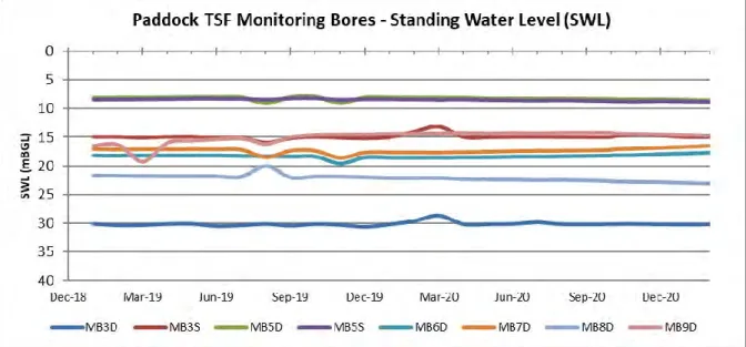
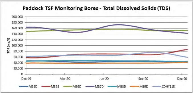
CDHY11, drilled downstream of the existing TSF, had a salinity of 120,000 mg/L with a standing water table of 22.46 m below ground (prior to construction and operation of the existing TSF). Standing water conditions are highest at the northeast edge of the facility at MB6s (7.57 mBGL in August 2016). The construction or operation of the facility is not expected to affect the populations of this species.
Groundwater is considered a sensitive receiver for TSF, hypersaline, static groundwater existed approximately 20 m below ground prior to the construction of the existing TSF. Monitoring of the spill site will continue quarterly for at least twelve months, and all monitoring results will be published in the annual environmental report. Localized detailed topography in the immediate vicinity of the TSF (cell 3) was evaluated for the case of a dry embankment failure.
Golder Associates Pty Ltd carried out an updated dam breach study as part of the Phase 7 Cell 1/2 design in August 2019. New ridge survey pins will be installed prior to the operation to track the movement of the embankment during deposition. The TSF embankment increase does not trigger any of the nine criteria for referral to EPA under the memorandum of understanding between DMIRS and EPA.
On May 3, 2018, an evacuation permit (CPS8000/1) was granted to clear up to 375 hectares for the evacuation of the Carosue Dam Expansion Project.
Existing Environment
Regional Setting
Geology
Land Systems and Soils
The Cell 1 / 2 tailings storage facility is located within the Deadman (Dea) and Morarity (Mor) land system of Pringle et al, 1994. The Deadman land system is characterized by level to gently undulating plains with red limestone soils deep and red soils on the calcrete. Brown clay soils over iron-gravel calcrete are common on the drainage flats and level to gently sloping alluvial plains of the Deadman land system.
Occasional variations of these soils include brown loamy clay over calcrete and shallow (less than 60 centimeters) calcareous red earth with calcareous rubble. The Morarity land system in the Cell 1/2 area consists of alluvial plains, level to very gently sloping plains with sparse mantles of quartz and ironstone pebbles, with deep red clay soil characterized by scattered shrubland of halophytic shrubs with scattered Eucalypta or Casuarina Cristata about story This land system is moderately susceptible to soil erosion if vegetation cover is removed and soil surface disturbed.
Flora and Fauna
Flora
These soils are often covered by mixed or separate pebble mantles of quartz, colored gravel and occasionally calcrete. And Drainage Zones, central unchannelized drainage tracts up to 400 m wide, with shallow duplex soils, characterized by scattered low chenopod shrubs, often dominated by Atriplex spp. No new disturbance is proposed through the Cell 1/2 Phase 8 Project, therefore no impacts to land or soil systems are expected.
Fauna
Malleefowl
Hydrology
Surface Water
Groundwater
Water levels generally decrease from the elevated areas such as the Relief Hill area (east of the mine) and the granite batholith (west of the mine) from levels of 350 and 360 mAHD, respectively (Figure 7) to 336 mAHD in the Whirling Dervish burial area. Productive aquifers in the Carsoue Dam area occur in bedrock and locally in alluvium. Permeability is enhanced in the zone of weathered rock between the saprolite and fresh rock, giving rise to a sub-horizontal aquifer zone 20 to 50 m thick.
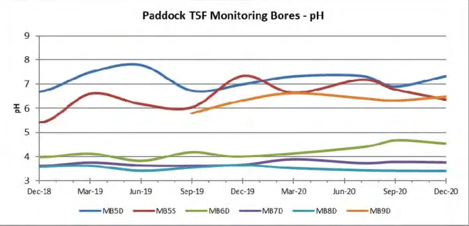
Groundwater accumulations are evident in the TSF area with water levels rising slightly in the north and west. In contrast, dewatering at Whirling Dervish has created a groundwater well with water levels in the South East corner (MB1D) dropping 26m. Water quality at SB02 is noticeably better as it is located higher in the aquifer in contrast to the other boreholes.
Ferrolysis
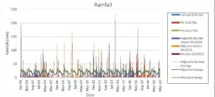
Climate
Sensitive Receptors
Threatened Ecological Communities and Priority Species
Groundwater
Lake Rebecca
Stygofauna
To minimize the potential for dust release beyond the TSF perimeter, salt water is administered via a water truck. Swaths are laid along roads and parking places to prevent the salt water from flowing away into the surrounding area. The pipelines and TSF will be inspected twice per 12-hour shift as part of the processing plant's daily operations.
In the event of a hypersaline or tailings spill, telemetry will automatically shut down pumps and isolation valves will be closed by site personnel. Cells 1/2 stage 8 will be used in conjunction with the existing cell 3 should emergencies arise. Construction will be supervised by a suitably qualified engineer to ensure that it is constructed in accordance with the design.
Modeling was performed at the final embankment height of 22 m, when the TSF will be at maximum storage volume to determine the worst case scenario. Groundwater levels around the TSF will be monitored on a quarterly basis under existing DWER license conditions. Any wildlife deaths associated with TSF will be reported to DWER; if fauna mortality becomes a problem, management measures will be implemented to prevent fauna from accessing the TSF (ie fencing).
No clearance is required as part of this proposal, therefore the development does not lead to any of the requirements of the Aboriginal Heritage Act 1972.
Assessment of Environmental Risks from Emissions
Risk Identification
Risk Assessment
Discussion of Key Risks
- Dust
- Damage to vegetation through rise in groundwater levels
- Contaminate groundwater through seepage of tailings liquor
- Fauna death through tailings exposure or entrapment
- Damage to Lake Rebecca
If local wind speeds are conducive to increased dust generation, construction work will be terminated until conditions improve. If the prevailing wind direction poses a risk of spillage beyond the perimeter of the facility, water truck operations will be terminated until the risk abates. Wetting of roads/access tracks will be done with dribble bars, which is a Northern Star requirement for all water trucks operating outside mine areas (ie haul roads).
Only qualified poly welders will be employed to construct the pipelines and welding certificates will be kept on site and presented on request. This will be submitted to DMIRS for review and approval via an associated Mining Proposal and Closure Plan. If monitoring shows that the water quality is deteriorating or the SWL rises above 4mBGL, a groundwater recuperation system is designed and implemented.
OTHER APPROVALS
The death of fauna through exposure or entrapment in tailings has not been a problem at Carosue Dam to date, due to the salinity of process water and barriers preventing access to the tailings beach. The TSF and associated infrastructure (i.e. landfill, roads and pipelines) have already had an impact on the surface water flow in the area. Seepage from the TSF is not expected to reach Rebecca Lake due to the isotropic nature of aquifers in the Carosue Dam area.
Flow is more likely to lie NW/SE parallel to Rebecca Lake than along strike to Rebecca Lake (Aquaterra, 2010b) and is heavily influenced by the rotating Dervish trough creating a drag effect.
Part IV Environmental Protection Act 1986, Environmental Impact Assessment
Other Decision-Making Authorities
Department of Mines and Petroleum
Northern Star currently has a groundwater permit, GWL157428(5), for dewatering the Karari, Whirling Dervish, Luvironza, Twin Peaks and Monty's open pits.
Application for: Clearing Permit (Area Permit or Purpose Permit) / Amendment of a clearing permit / Surrender of clearing permit / Notice of change of land ownership - Application form: Approval of works / License / Renewal / Change / Registration / approval or surrender works license / Transfer of approval or works license or Notification of new occupier of registered premises.