A checklist of many of the development checks is included as a summary in Appendix A of this part of the DCP. The shape of residential development is determined by this portion of the DCP and specific place maps.
INTRODUCTION
LAND TO WHICH THIS SECTION OF THE PLAN APPLIES
AIMS AND OBJECTIVES OF THIS SECTION
OBJECTIVES AND DEVELOPMENT CONTROLS
DEVELOPMENT CONTROL MAP SHEETS
The purpose of this section of the plan is to provide for the control of residential development within the Rouse Hill Development Area. The purpose of this section of the plan is to provide additional controls on residential development within the Balmoral Road relief area. i).
SITE SPECIFIC DEVELOPMENT CONTROLS
In addition to this section of the DCP, Council has adopted a number of site-specific development controls to address issues specific to certain areas. To reduce the risk to development due to geotechnical constraints. a) Development must be restricted to specified environmentally sensitive locations as identified on the location maps for this Section of the DCP (Part B Section 2).
RESTRICTED DEVELOPMENT AREAS
In the event of any inconsistency between this Section of the DCP and site-specific DCP sections, the site-specific DCP section shall prevail only to the extent of the inconsistency. To minimize adverse impacts on the environment in accordance with Council's ESD objectives 3 and 4. a) Development must be designed to respect site constraints such as topography, drainage, soil, landscapes, flora, fauna and bushfire risk.
SITE ANALYSIS
To facilitate the development of a design that minimizes the negative impacts on the amenity of adjacent residential development in accordance with Council's ESD objective 7. iv). To ensure that the appearance of new development is of a high visual quality, it enhances the streetscape and complements surrounding development. ii) To ensure that new development is sensitive to the landscape setting and environmental conditions of the locality. iii).
STREETSCAPE AND CHARACTER
The relationship of these elements creates a character that contributes to the "look and feel" of the street, a sense of place and identity. Achieve development that respects and positively contributes to the character and "sense of place" of Castle Hill. vii).
BUSH FIRE HAZARD MANAGEMENT
A fire hazard development will be required to meet the requirements in these guidelines. To ensure that the proposed development does not cause displacement or slippage. ii) To ensure that ground movement or land slip does not adversely affect the proposed development. a) Areas that may be subject to movement or sliding are identified on The Hills LEP 2012 Landslide Hazard Maps or have been identified by Council as being subject to movement or sliding.
GEOTECHNICAL SITE STABILITY
To ensure new development, The Hills respects and enhances the Shire's green and garden character. we). Any part of the site shown as being subject to geotechnical constraints on the site specific maps for this section of the DCP or identified by Council to be considered subject to movement or sliding shall be identified on the site plan.
BUSHLAND AND BIODIVERSITY
Applications must include a Fauna and Flora Assessment in accordance with Section 5A of the Environmental Planning and Assessment Act 1979 if there is likely to be a significant effect on threatened species, populations or ecological communities or their habitats. Reference should be made to the requirements of the Environmental Planning and Assessment Act 1979, and the Conservation of Threatened Species Act 1995. i) Minimize land degradation, water pollution and damage to infrastructure from accumulated sediments in accordance with ESD objective 3 of the Council. ii) To ensure that development controls are identified for all stages of development and to ensure a sustainable approach to erosion and sediment control. a).
EROSION AND SEDIMENT CONTROL
To encourage the reuse of storm water. a) Water Sensitive Urban Design (WSUD) measures should be used in site/development stormwater management in terms of water retention, reuse and treatment. Throughout the development, consideration should be given to the use of one of the following water sensitive urban design measures: -.
HERITAGE
The size, shape, material and location of signage should complement the visual character of the surrounding area. i). A detailed description of the actions required to implement each of these measures is included in Appendix B – Water Sensitive Urban Design of the Hills Shire Development Control Plan.
SIGNAGE
Ensure that the integrity of watercourses is protected and enhanced in accordance with objective 4. iv) ESD of the Council. Requirements for their installation and use are included in Appendix B - Water Sensitive Urban Planning under the heading:.
STORMWATER MANAGEMENT
In these circumstances, a letter of consent from the owner(s) of the downstream properties must be submitted with the Development Application. The controls relating to the erection of a dwelling must still be considered at the subdivision stage to ensure that all plots created can accommodate a suitable dwelling in accordance with this Section of the DCP.
SUBDIVISION
Apart from the land zone E4 Eco-housing, where the minimum frontage is 23m. c) The minimum depth on plots where a dwelling is permitted is 27m. This is required to ensure that vehicles parked on the driveway in front of the garage do not encroach on the road reservation. f) The maximum width of a dwelling must be:.
DWELLINGS
The total land area will be used in the area coverage calculation. The location and dimensions of the private open space should be shown on the Site Plan.
FENCING
Ensuring that the fencing has a high visual quality, matches the character of the area and is in line with the proposed development. To minimize the overall environmental impact of waste. ii) Maximize, through appropriate design, the possibilities to handle municipal waste according to the waste hierarchy as given in Council ESD target 6. iii). To provide household waste management systems, in line with Council ESD Objective 6, that are easy to use for residents and easy to maintain for collection companies. iv).
WASTE MANAGEMENT
Promote improved project management and reduce the demand for waste disposal during demolition and construction in line with Council ESD Objective 6. ii) Maximize, reuse and recycle building/construction materials in accordance with ESD target 6 of the Council. iii). Encourage building designs and construction techniques that minimize waste generation in accordance with Council ESD Goal 6. iv) Minimize waste generation to landfills through the waste hierarchy in line with Council ESD target 6. v) Assist in achieving federal and state government waste minimization goals. a) Site operations shall provide for planned work phasing, source separation, reuse and recycling. of materials and ensure appropriate storage and collection of waste. Appendix A of The Hills DCP 2011 contains a template that can help you prepare a WMP. i).
SERVICES
Ensuring that pools are positioned so that they are not visually prominent from the street. ii) Ensuring that the comfort of neighboring owners is taken into account in the placement and design of swimming pools. a) Pools must not be located within the front or secondary boundary. Please refer to Part A – Introduction, Section 4.0 for general filing requirements and detailed requirements to be included in each of the above documentation. Display footpath and sidewalk widths for all proposed roads, proposed road widening, and corner splits;.
SWIMMING POOLS
INFORMATION REQUIRED FOR A DEVELOPMENT APPLICATION
DWELLINGS AND ADDITIONS / ALTERATIONS TO AN EXISTING DWELLING
SUBDIVISION APPLICATIONS / SMALL LOT HOUSING UNDER CLAUSE 4.1
The following reports may be required depending on the nature of the site and application. Lake Macquarie City Council, Speers Point, on behalf of the Lower Hunter and Central Coast Environmental Management Strategy. Faculty of Built Environment, RMIT University et al, Australia's Guide to Good Design – Residential, Prepared on behalf of the National Bureau of Local Government.
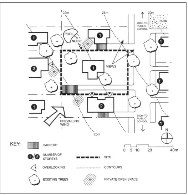
CORNER OLD WINDSOR ROAD AND SEVEN HILLS ROAD, BAULKHAM HILLS
CORNER OLD WINDSOR ROAD AND SEVEN HILL ROAD, BAULKAM HILLS. i) Dwellings should be designed and/or sited to maximize views. ii) Views of the property from public places such as the proposed highway, open space and surrounding roads should be considered during the design phase. a) The apartments will be designed to maximize the existing views to the east and south. i) Creating an attractive, interesting and pleasant streetscape through the placement of buildings and landscaping. ii). In cases where multiple car parking is required in front of garages, the minimum setback shall be 5.5 meters in the garage. To allow free circulation on property roads. a) Two on-site car parking spaces must be provided for each dwelling.
HUNTERFORD ESTATE, OATLANDS
The layout of the site should take into account the views available from the south-east corner of the site. The side setback will be increased to reduce any impact on views and overshadowing on adjacent dwellings within the small lot housing scheme (see clause 4.1B of The Hills LEP 2012). The required private open space is at least 20% of the land area with a minimum dimension of 3 metres.
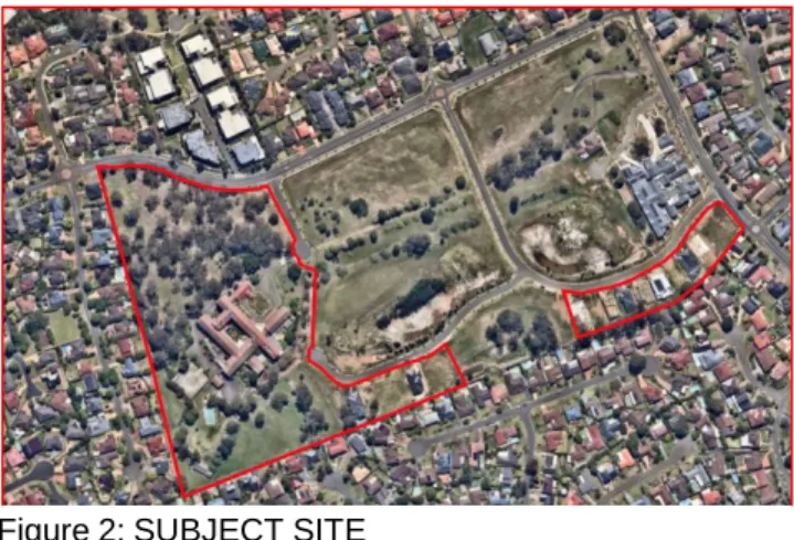
LAND ADJOINING HERITAGE PARK
To preserve residents' views of open space and areas of limited development. ii) Ensure that the development of the subject land has as little impact as possible on the views of residents and visitors to the area. a) Landscape and building design and siting should take account of topography to ensure impact on views from: The following building restrictions apply to small plots (See Clause 4.1B of The Hills LEP) within the area known as Land adjoining Heritage Park. i) Create an attractive, interesting and pleasant street by placing buildings and landscaping. ii). Provide sufficient and convenient parking for residents and visitors to maintain the amenity of neighboring properties and the efficiency of the road network. ii).
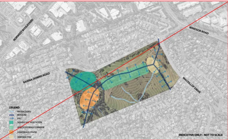
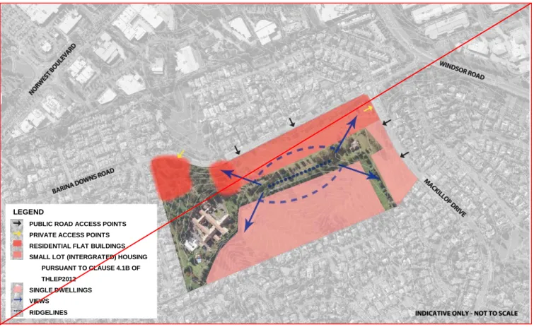
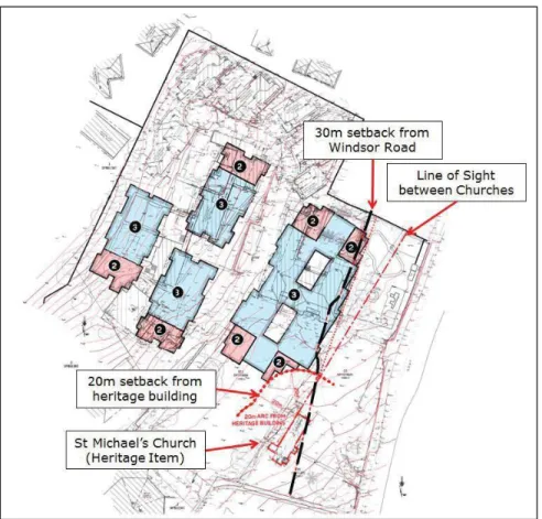
GILROY COLLEGE TARGET SITE
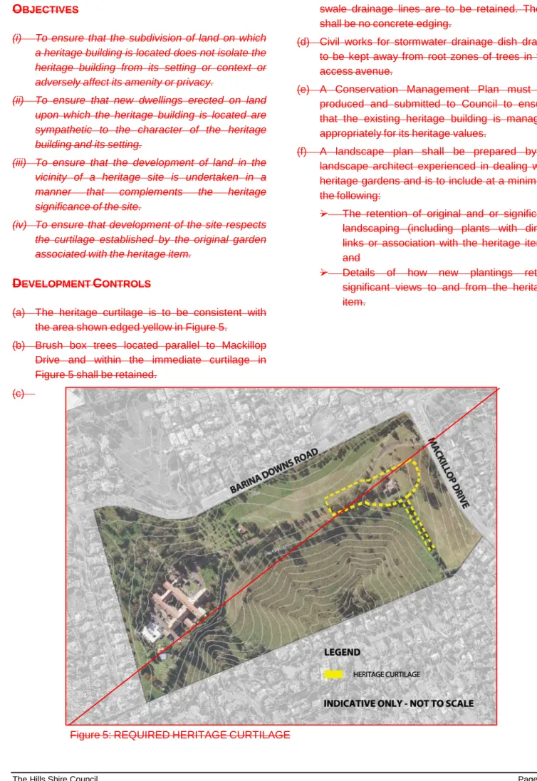
To ensure that development of the area takes into account the curtilage established by the original heritage garden. a). The rural characteristics of the bituminous avenue with drainage lines must be preserved. A minimum clearance of 10 meters must be provided at the southern border of the construction site.
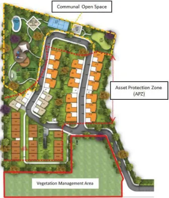
To foresee setbacks that are complementary to the setting and contribute to the streetscape and character of the street. Most of the common open space gets direct sunlight between 9am and 3pm in the middle of winter. i).