INTRODUCTION
BACKGROUND
DESCRIPTION OF THE PROJECT
M ETHODOLOGY
- Preliminary Desktop Study
- Site Investigation
A preliminary assessment of the project area and its potential constraints was undertaken by reviewing a number of records managed by government agencies. A preliminary assessment of the project area and its potential constraints was also undertaken by the GHD in June 2004. The location of wetlands within the project area was determined using the mapping tool of the Commonwealth Department of Environment and Heritage (DEH), Department of of the Environment (DoE) Environmentally Sensitive Area (ESA) mapping tool (http://portal.environment.wa.gov.au/portal/page?_pageid amp;_dad=portal&_sc hema=PORTAL) and seeking advice from the officer regional DoE.
A search from the Department of Indigenous Affairs (DIAs). http://www.dia.wa.gov.au/Heritage/SitesSurveysSearch.aspx) database was undertaken to determine whether the project area contained any Aboriginal heritage sites, refer Appendix E. The Water Information Officer of the Department of Water regional office was consulted on sensitive water sources (including Public Drinking Water Source Areas) to determine if the project area supports, or was adjacent to, any significant lakes, rivers or wetlands or proclaimed areas, refer Appendix F. The project area is within a reserve managed by Main Roads remained and there is no evidence of contamination, therefore it is not considered a contaminated site.
The Western Australian Planning Commission's Acid Sulphate Soil Maps were reviewed and a self-assessment was carried out (http://www.wapc.wa.gov.au/Publications/213.aspx) to determine what level of risk the area is exposed to. of the project, refer to Appendix G. Consultations were undertaken with the Department of Agriculture to determine if there are any known populations of declared plants or significant weeds within or near the project area, refer to Appendix H.
EXISTING ENVIRONMENT
The decision to refer the project to the Commonwealth DEH was based on the question of whether the project would have an impact on matters of national interest, e.g. World Heritage properties, protected wetlands and migratory species, Commonwealth marine areas, threatened species or communities or nuclear actions (refer to the Commonwealth web page www.deh.gov.au/epbc/assessmentsapprovals/index.html for further information and the search tool page at http ://www.deh.gov.au/erin/ert/epbc/imap/map.html), refer Appendix I. A site visit was carried out on 12/05/06 by Matthew Oswald to determine the general characteristics of the area investigation. Other issues considered include topography, the impact on creek lines, access to property and the potential for noise and vibration impacts (deterioration).
A narrow strip of vegetation around the clay pans on the south-western and north-eastern parts of the study area includes a few species that differ from the surrounding areas. Scaevola spinescens, Olearia Muelleri, Commicarpos australis, Halosarcia sp, Rhagodia sp., Meulenbeckia cunninghamii and Lycium australe. The presence of the trees is usually an indication of shallower water tables and periodic flooding.
Trees occur relatively densely along the edges of the stream bed and become sparser for a distance of about 150 m on either side of the stream. Oleifolius, Marsilea drummondii, Abutilon sp., Stemodia viscose, Amyema sp., Exocarpos aphyllus, Sclerolaena sp., Atriplex semilunaris.
CLEARING OF NATIVE VEGETATION
Both species were not observed in the field survey carried out as part of the GHD (2004) report (Appendix C). These species were not observed in the field survey carried out as part of the GHD (2004) report (Appendix C). None of the species listed in the table were observed during a site survey by John Stretch (Ministry of Agriculture) on 28/08/06.
A search of the online databases of the Australian Heritage Places Inventory, Heritage Council of Western Australia and the Shire of Carnarvon's Municipal Heritage Inventory revealed that there are no heritage sites present in the currently proposed work areas. The requirements of the Shire of Carnarvon regarding noise control and construction working hours must be met. Provided that traffic management and signage are applied according to the standards of the major roads, none of the proposed works pose a significant threat to public safety.
Given the size of the project, the minor significance of its impacts on the environment and the proposed environmental management measures, the project does not need to be referred to the WA Environmental Protection Authority or the Commonwealth Department of the Environment and Heritage. This part of the report (the EMP) is developed for the project area upon completion of the above parts. Construction Ensure that the construction of the proposal does not cause any inconvenience to the public.
Works associated with the construction of the development must not impede public access along the adjacent reserve. Construction Ensure that the construction of the proposal is managed to a standard that minimizes any negative impact on the environment. If any material of significance to Aboriginal people is discovered, work will cease immediately within 100m of the material and the site will be examined by a qualified archaeologist.
The final clean-up must be done to the satisfaction of the project manager and the construction manager. Report on the results of an archaeological investigation of the Carnarvon Flood Mitigation Works, Carnarvon, Western Australia for Main Roads Western Australia. The department requests that care be taken in relation to the environment in relation to the renovation of the work area.
The purpose of the project is to improve the safety of the highway during floods. In order to carry out the works, it is necessary to build a side ramp on the east side of the highway that crosses part of the stream.
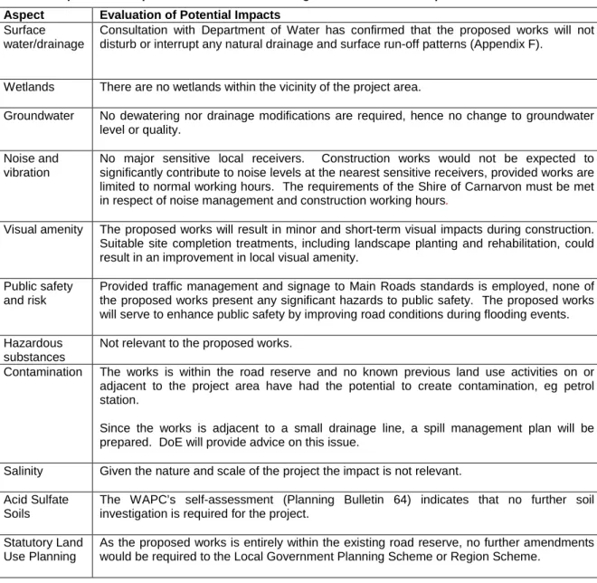
ASSESSMENT OF ASPECTS AND IMPACTS
DECISION TO REFER
ENVIRONMENTAL MANAGEMENT PLAN
DEPARTMENT OF ENVIRONMENT AND HERITAGE DATABASE
