Nothing in this manual shall be construed as limiting, in any way, Council's rights to impose different conditions when approving development proposals, nor limiting the discretion of Council's Manager - Subdivision and Development Certification or their appointed representative to vary any necessary engineering requirements in relation to a particular development, having regard to good engineering practice. Council Hills Shire Council represented by its employees Manager Manager - Subdivision and Development Certification.
Scope
Aim
Process for the Applicant
Construction – The Councilor will employ a contractor to carry out the works in accordance with the approved plans, condition approval and Council's site specification – Subdivisions/Developments. The Council's Engineer shall be notified when all deficiencies have been rectified to carry out the final inspection.
Engineering Survey
Engineering Construction Certificate
Persons Qualified
Consultation
Inspection of Works
Tree Preservation
Street Trees
Erosion and Sedimentation Control
Land and water management plans will be prepared in accordance with the Department of Environment and Conservation, Landcom's Guidelines. Urban Storm Water Management – Land and Conservation – Volume 1” 4th Edition (2004) and are part of the engineering drawings.
Road Safety Audit and OH&S Requirements
Engineering Fees
Works-As-Executed (W.A.E) Plans
Certificates
Contributions
Bonds
Scope
Aim
General Requirements
Title Blocks
Road and Drainage Drawings
On-site Storage Detention Drawings
Title Sheet
Detail Plan
Existing services including sewer, water, telephone, gas, electricity, etc., together with all associated wells, poles and other structures.
Road Long Sections
Road Cross Sections
Typical Road Cross Sections
Kerb Return Details
Traffic Calming Devices, Pathways, Cycleways and Other Miscellaneous Details
Drainage Catchment Plan
Drainage Calculations
Drainage Longitudinal Sections
Other Drainage Details
Erosion and Sedimentation Control Measures
Traffic Control Measures
Traffic Regulation (Permanent)
Work-As-Executed Plans
Lot Filling
All imported fill material to be used must be tested and certified as Natural Excavated Material (ENM). The minimum plot concentration should be 1% and 100mm of topsoil should be placed over all fill soil and graded to prevent water pooling.
Sheet Sizes
Each residential lot, whether infilled or not, shall be graded in accordance with the Australian Standard for Residential Slabs and Linings (AS 2870). If approval is obtained to extend the fill to adjacent properties (written consent required), satisfactory arrangements must be made for placing the fill on the site without excavation.
Scales
Compaction shall be in accordance with Section 4.9 of Subdivision / Developments of Council's Works Specifications – Placement and Compaction of Fill.
Dimensions
Scope
Aim
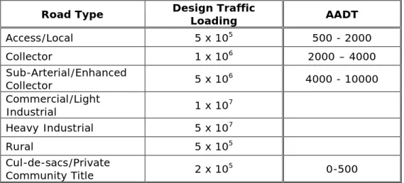
Planning Standards
Design Speed
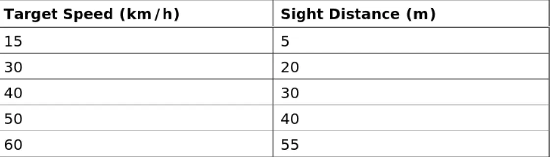
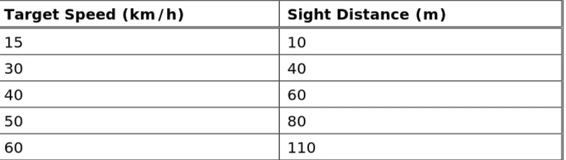
Sight Distance
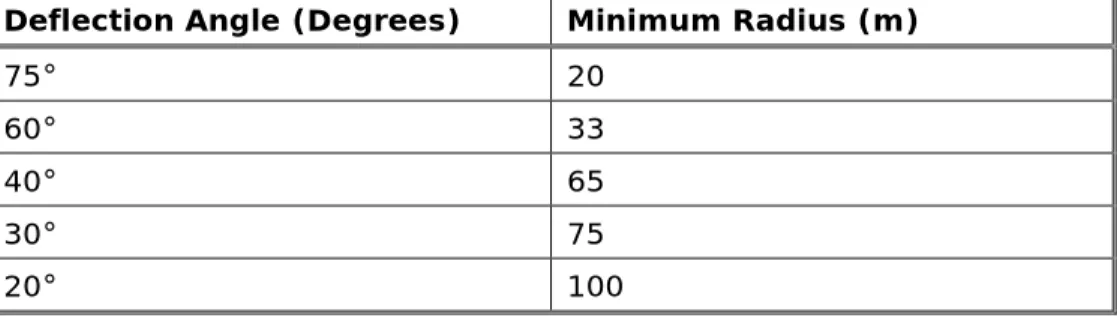
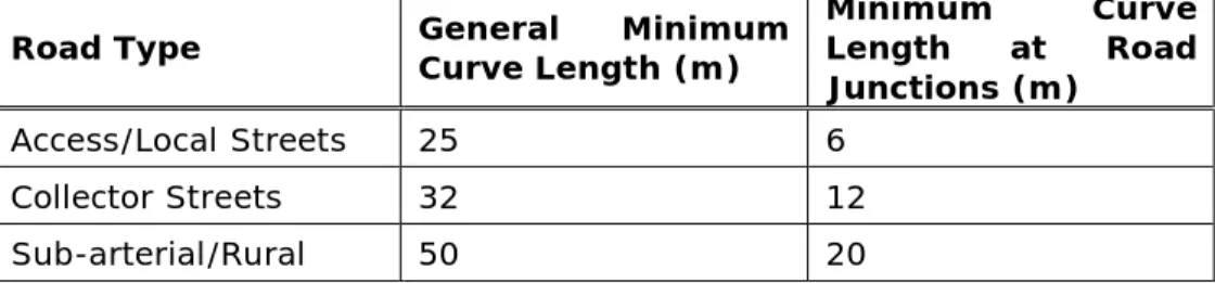
Horizontal Alignment
Transitions and Widening on Curves
Vertical Curves
Super-Elevation
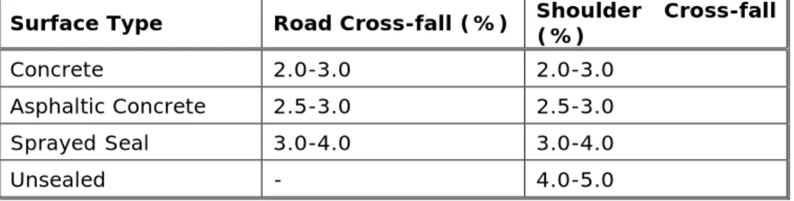
Carriageway Crossfall
Pavement Design
The pavement for roundabouts shall consist of deep-lift asphalt concrete placed on 150 mm rolled concrete (5 MPa) according to the manager's requirements. Rural cul-de-sac must be provided with a minimum 25 mm thick asphalt concrete wear layer at the head of the cul-de-sac to the tangent points.
Kerb and Gutter
Footpath Crossfall
Berms
Batters
The rock punch slopes mentioned above refer only to incised punches in solid rock with some clay bands. Where the above gradients cannot reasonably be achieved, deviations may be permitted subject to the approval of the Manager. If a retaining wall is required, the developer must provide full engineering details of the proposed structure, including elevation, typical cross-section and structural certification.
Intersections
Kerb Returns
Cul-De-Sac Head Kerb Grading
Roundabouts
Traffic Calming Devices
Scope
Aim
General Requirements
An overland flow system shall be provided for flow exceeding the capacity of the piping system, such that the designed flow is carried through the subdivision or remote development and with the required allotment board. Pipe channels or concrete boxes, bridges or concrete causeways should be provided at road crossings over natural watercourses to the boundaries of the road formation. Where services are underground then these services shall be carried above the structure in a service corridor approved by the Manager.
An overland flow system shall be provided for flow in excess of the capacity of the piping system, such that the designed flow is carried through the subdivision or development, away from and with the required free board, to the building platforms.
Lawful Point of Discharge
An overland flow system shall be provided for runoff in excess of the capacity of the piping system so that the design flow is carried through the substructure or construction without and with the required headwater to the construction platforms. the neighboring owner can file a lawsuit or a claim for damages for damage caused by the nuisance). If the conditions of the first test have not been met prior to development, a legal release point will need to be obtained. This is usually accomplished by creating a drainage reserve or, if approved by the manager, by acquiring a drainage easement over one or more downstream properties until the conditions of the second test are met.
It should be noted that a natural watercourse does not necessarily constitute a legal discharge point, unless the requirements in the above two tests can be met.
Flood Studies
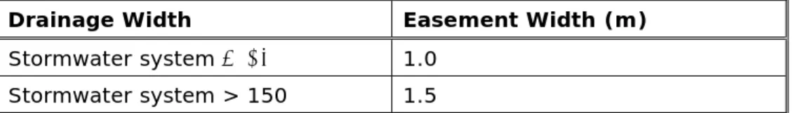
Drainage Reserves/Easements
Hydrology
Design Average Recurrence Intervals (ARI)
Time of Concentration
Rainfall Intensities
Run-off Coefficient
Catchment Area
Hydraulics
Minor Drainage System Criteria
Accurate contour information is required for the determination of sub-basins within urban allotments and a river basin plan should be provided with the calculations. The water level for intake wells should be 0.15 m below the back of the gutter or 0.15 m below the bottom of the cover for connection wells.
Major Drainage System Criteria
Roadway Flow Capacity
Pits
There must be a minimum opening of 1.8 meters for uphill pits and 2.4 meters for immersion pits for curb inlets. The minimum dimensions of surface inlet pits for use on development sites shall be 300mm x 300mm.
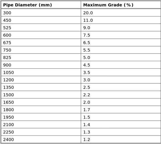
Pipes and Culverts
Grades in variation to the above may be approved by the manager, but where grades exceed 15.0% bulkheads must be supplied in accordance with the Council's works specification – Subdivision/Developments. The minimum velocity in the pipe and box flow must be 0.6 m/s for self-cleaning purposes. All pipe inlets must enter the main pipe system at joint holes and must be cut flush and grouted into the well wall.
If these connections are approved, the pipe must be aligned and grouted into the main pipe wall.
Hydraulic Losses
Open Channels
The maximum desirable side slope should be 1:6, the absolute maximum should be 1:4 and the cross slope for the channel floor should be 1:20. Low-flow provisions shall be provided in man-made or altered channels by providing piping, concrete lining, or subsoil drainage. Vegetated stream lines will be maintained in their natural state with improvements to prevent erosion due to increased frequency of silted streams and urbanization.
Inverts of low flow creeks should be designed as a wet invert and planted with suitable riparian vegetation.
Bridges and Culverts
On-Site Stormwater Detention
Rainwater detention on site must not take place in catchments that drain to an approved retention system. Council's subdivision and development certification section can advise which catchment area applies to the proposed development and the on-site retention requirement. Maximum depth of 600mm in above ground systems, 200mm depth in driveways, car parks and walkways.
Desirable maximum side slopes of 1:6 for above ground pools, the absolute maximum should be 1:4 and the minimum floor slope should be 1:50.
Inter-allotment Drainage
If an OSD system is to be connected to a drainage system between assignments, the IAD pipe must be covered by a minimum of 1.0 metres.
Stormwater Discharge
Water Sensitive Urban Design
Additionally, the WSUD must consider water quality, flow stability, flow attenuation, and runoff volumes. All proposals must incorporate WSUD measures in a new development and will be submitted to Council for consideration with the Development Application. Any proposal to incorporate WSUD measures is to recognize and design for ongoing operation and maintenance requirements.
WSUD measures will be designed and constructed in accordance with Council policy requirements and the following publications.
Gross Pollutant Traps
WSUD's measures are to ensure sustainable and integrated management of land and water resources, including best practices of stormwater management, water conservation and environmental protection measures. In general, treatment of a 3-month ARI design flow from a catchment will result in treatment of a significant portion of the flow. Maintenance requirements - ease of operation of the equipment, convenient all-weather access, adapted to the required maintenance equipment and systems, frequency of maintenance and waste disposal.
Scope
Aim
Pathway and Cycleways
Battleaxe Handles
The construction of a closed sidewalk and/or passing lanes will depend on the existing site features and consideration should be given to sight distances, existing trees, slope, drainage and length of access handle.
Access Driveways
Disused Laybacks and/or Footpath Crossings
Applications
Temporary Roads
Partial Road Width Construction
The final road configuration is consistent with the pre-planned road layout and road type from Council's Development Control Plan (where applicable). Engineering plan for partial and full width road works, including details of any necessary drainage and utility service requirements; and. A road safety report prepared by a suitably experienced professional showing how the partial road proposal ensures safe use by all road users.
Any work to be carried out, or requiring easements, on adjoining properties shall be approved by the owner(s) of such land and appropriate documentary evidence of such approval shall be submitted to Council.
Street Names
Bridges and Culverts
Safety Barriers for Roads and Bridges
Encroachment in Council Drainage Easements
The proposed works must not interfere with the rights granted to the Council, specifically in relation to the maintenance of the pipe and other structures within the easement. Any proposed encroachment structures must be registered on the title of the subject site by means of a deed with the Council. The purpose of the deed is to protect the Council's rights of access to the service delivery area, which requires the removal of the encroaching structure.
All costs associated with the preparation and registration of the deed will be borne by the person seeking approval for these works.
Encroachments in Private/ Inter-allotment Drainage Easements
Primarily, this relates to maintenance of the pipe and other structures within the easement. For example, the cost and work involved in excavating a pipeline for maintenance purposes in its pre-development and post-development state (over its entire length) can be compared and if the difference is insignificant, it can be argued that the work does not affect this aspect of the rights of the beneficiary parties. Any constructions that are proposed within or adjacent to the easement as part of the works (e.g. a retaining wall) must be designed so that they do not strain the rainwater pipe in the easement.
If a cut is intended to be within a drainage easement between lots, a minimum pipe cover shall be provided.
Insurance and Workers Compensation
If a cut is proposed within an easement with drainage between allotments, the impacts (if any) on the hydraulic line and the potential for surcharges must be considered. A "Traffic Control Plan" must be prepared by a suitably qualified RTA-accredited workplace traffic designer for all works carried out in or adjacent to a public road. It is the Applicant's sole responsibility to have and maintain traffic facilities, i.e.
All changes to the approved traffic control plan must be approved by council prior to implementation.