Executive Summary
- Introduction
- Vision and Intentions for the CTA
- Outcomes
- Key Issues
- Planning and Development
- Challenges from Residents
- Reduced Viability for Developments
- Suitability of the Rural 3 Product
- Summary
- Recommendations
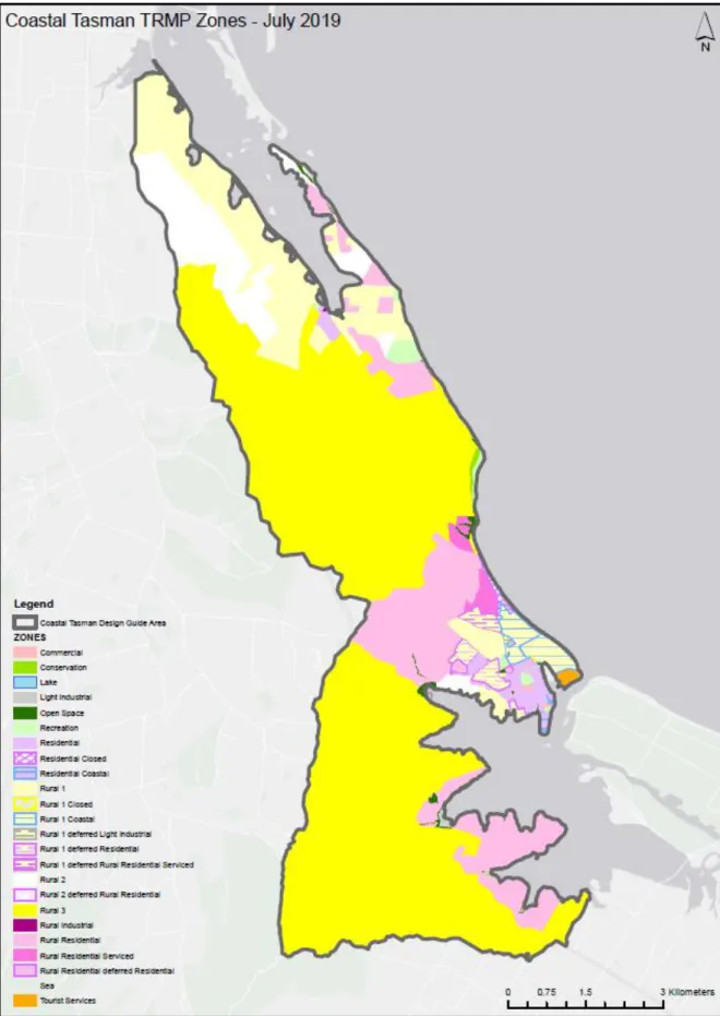
- The Coastal Tasman Area
- Rural 3 Zone
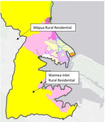
- Māpua Village and Māpua Rural Residential
- Waimea Inlet Rural Residential
- Northern Rural 1 / Rural 2
- Kina Peninsula
- Tasman Village
- Other Recommendations
The route of the TGTT through the northern part of the Rural 3 Zone is an additional recreational advantage. In the absence of wastewater service, the construction of housing in large parts of the CTA has relied on on-site wastewater treatment and discharge systems. Typically, CTADG and the location of less productive land (class E) have provided more support for the development of rural lifestyles in the upper areas of the CTA valleys.
Rethink the boundaries of this zone in light of the decisions made around the Rural 3 Zone and the character of the development opportunities in the current Waimea Inlet Rural Residential Zone.
Introduction
Scope of this report
Background to the Coastal Tasman Area
In October 2010, the Ruby Bay Bypass was opened in the northern part of the GTA. The TGTT enters the GTA at Māpua and meanders through key areas such as Ruby Bay, Marriages Road, Aporo Road, Tasman Village, Harley Road and Tasman View Road, eventually ending up near Riverside Community in the Moutere Valley. As described in more detail below, the GTA was originally envisioned to provide for rural residential and rural lifestyle opportunities.
Summary of Consultation
- Tasman District Councillors
- Tasman Environmental Policy Iwi Working Group
Vision and Intentions for CTA Zones
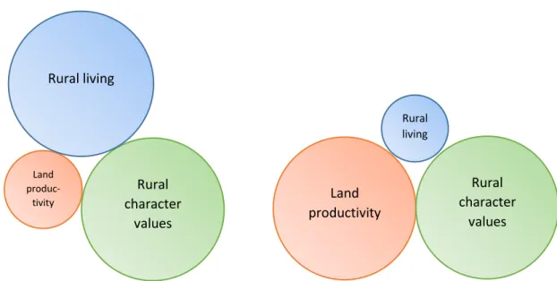
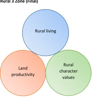
- Rural 3 Zone
- Characteristics
- Early Policy Development (2000 to 2002)
- The Formal Changes Proposed – Variation 32 (2003)
- The Decisions
- Final Rural 3 Zone Provisions
- Summary
- The Coastal Tasman Area Design Guide
- Significant Transportation Changes
- Māpua and Waimea Inlet Rural Residential Zone Locations
- Rural 1 and Rural 2 Zones (the North-West Extension Area)
- Kina Peninsula and Permin Road
- Māpua Settlement
- Cultural Heritage Values
- The Wastewater Management Area
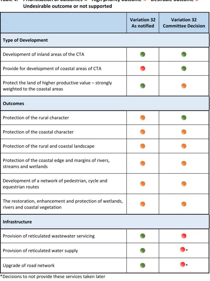
A serviced residential development of suitable portions of rural land in the Tasman coastal area, integrated with the development of Māpua-Ruby Bay and Tasman Village. In the context of a district, they are considered to be official planning objectives [7.1.2 and 7.2.2]. Protection of rural and coastal landscapes Protection of the coastal edge and edges of rivers, streams and wetlands.
The Variation sought policy changes to allow for more intensive development in the Māpua Rural Residential Zone and to recognize the coastal character of the Waimea Inlet Rural Residential Zone. In fact, virtually the only remnants of Zones Rural 1 and Rural 2 within the CTA occur along this part of the coast. The only additional policy was 7.3.3.21, which was to provide for the longer term (after 15 years) maintenance of the sites in the rural residential zone near Permin Road.
Outcomes
- Methodology
- Evaluation Process
- Certificates of Title
- Subdivision Consents
- Rural Lifestyle Living
- Numbers of Lots
- Qualities and Characteristics of Rural Lifestyle Lots
- Costs of Lots
- Plant and Animal Production
- Amenity and Cross Boundary Effects
- Rural Character and Visual Amenity
- Recreational Linkages
- Natural Character and Biodiversity
- Cultural Heritage Outcomes
- Water Quality Outcomes
- Nutrients and Pathogens
- Sediment
- Summary of Outcomes
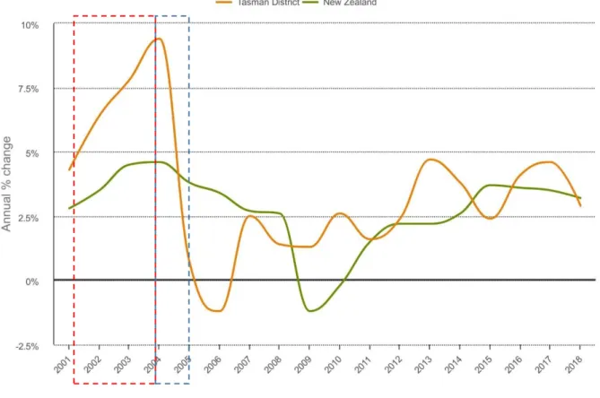
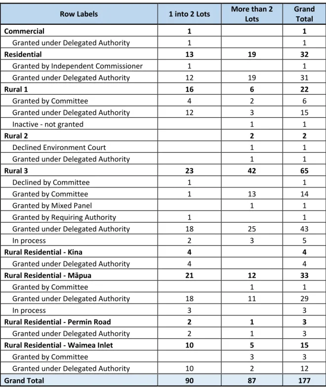
According to the numbers above, since the implementation of the Rural 3 zone, there have been an additional 474 lots that are smaller than 6 acres. A map of the new titles authorized by Rural 3 subdivisions (ie under the Rural 3 rules) is provided as Appendix 7. Also included are some larger lots that are integral to the design of the subdivision.
In general, it is clear that the majority of plots are in the residential range and rural-residential range. The axiom of the Rural 3 zone is to enable more people to acquire a rural lifestyle living in a rural environment. In November 2012 Council engaged David Sissons (Landscape Architect) to provide an assessment17 of the impact of consent building on the rural character of the Tasman Coastal Area18.
The provisional conclusion was that the Tasman Coastal Planning Guidelines and the subdivision of the area fail to protect the rural character of the Rural 3 zone in the face of increased residential use. 17 Sissons, D (2012) 'Assessment of the Rural Character Impact of Consensual Development in the Tasman Coast and Rural 1 and Rural 2 areas outside the Tasman Coast'. In the case of Tasman Bay Estates Ltd (formerly Harakeke Ltd) subdivision, a Pā site has been identified to be allocated to Manawhenua Iwi.
Deposition of sediment from erosion in the Waimea and Moutere River catchments is a major problem. Since 2003, the Rural 3 zone has achieved a series of positive outcomes, but some of the intended outcomes have also not been achieved satisfactorily.
Discussion of Key Issues
- The Planning Framework
- The Policies of Chapter 7
- Inconsistency between Chapter 7 Policies and the CTA Design Guide
- Internal consistency within the CTADG
- Challenges from New and Existing Residents
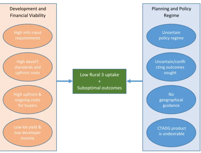
- Reduced Viability for Developments
- Suitability of the Rural 3 Product
- Costs, Affordability and Complexity
- Community Consolidation, Cohesion and Commerciality
- Cross-Boundary Effects
However, it is also observed that the philosophy of the TRMP at the time was largely not to write zone-based objectives and policies25. It is debatable whether this was reflective of the policy intent which constituted broad discretion. Should the land be compared to the rest of the CTA or the rest of the District?
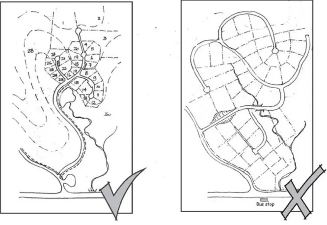
With the shift to on-site disposal of wastewater, this became impractical and the resulting low-density subdivision pattern resulted in parts of the Rural 3 zone becoming de-facto rural-residential. Much of the content of the CTADG was provided by Frank Boffa who was a prominent landscape architect. It is unclear whether consideration was given to the likelihood of achieving the layouts promoted by the CTADG in light of the need for waste water on the site.
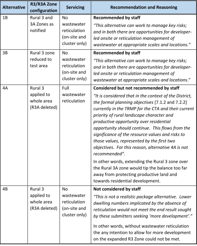
Ms. Leusink-Sladen identifies the main torpedo to the success of the Rural 3 zone as the removal of the wastewater service. Ms. Leusink-Sladen is not suggesting that the removal of this service was per se incorrect; only that the ambition and intention of the Rural 3 depended on its maintenance.). This is a somewhat unavoidable part of the Rural 3 model and no one-size-fits-all solution seems obvious.
A commercial center (probably including a coffee shop if there is a critical mass in the community) can reduce the need to travel outside the community to socialize at the coffee shop. Finally, the Rural 3 area was excluded from the scope of the Rural Review, so issues of cross-border effects between residential and manufacturing activities remain.
Summary
The analysis undertaken for the Rural Review (PC60) clearly showed that transboundary effects (A) caused a significant impact on residential amenity, and (B) cumulatively caused a significant effect on productive activities. Currently, there is also the potential for new residential activities in rural areas to put pressure on existing rural productive activities to limit their impact. The setback rule for habitable buildings is 5 meters from the boundary, while for other rural zones (after PC60) it is now 30 metres, except where it adjoins a site of 2,500 square meters or less.
As the Rural 3 zone is intended to remain a bona fide working and productive rural environment, it seems appropriate that a similar approach be considered there as well. Rural character in the Rural 3 area generally remains high, but evidence suggests that the observed development of the Rural 3 style will undermine this character. Are there too many competing demands, and are all the seemingly desirable outcomes simply too difficult to balance in the real world?
In the event that the GTA and the Rural 3 zone remain part of the planning landscape in Tasman, it is likely that there will need to be changes to make it function more effectively and efficiently. Changes will also be needed to better reflect the cultural and archaeological values of the area, and to recognize and cater for the regional asset that is the Tasman Great Taste Trail. Ongoing challenges exist in the area of environmental impact on water bodies and on the estuaries into which they flow.
These effects are due to the erosion of sediment and the cumulative discharge of wastewater onto land. The Coastal Tasman Area remains a distinct geographic area within Tasman that offers plenty of scope for the kind of innovative and high-quality developments that were originally envisioned.
Appendices
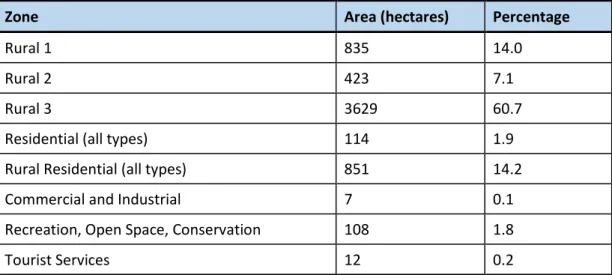
- Appendix 1 – CTA zone comparison maps and land areas
- Appendix 2 – Planning maps progression
- Appendix 3 – Policy diagram
- Appendix 4 – Interview notes – Mayor Kempthorne and Councillor King
- Appendix 5 – Interview notes – Steve Markham and Sonya Leusink-Sladen
- Appendix 6 – CTA policies – Section 7.3 TRMP
- Appendix 7 – Map of Productive Land Classifications versus Rural 3 Development
- Appendix 8 – Key Data
Productive values are not the main driver, just one in the mix and it was expected to be developed in some innovative form. The transferable development opportunity in the Rural 3A Zone creates significant administrative challenges for landowners and the municipality over time. There is a desire in the community for residential development opportunities in a rural part of the district that are productively used and have existing rural residential development.
Managing the pressure for and cumulative effects of residential development in the Coastal Tasman area, which is a rural area close to the coast, to the district's main urban centres, and to major transport routes, while the productive value of the rural land resource, coast is protected. and rural character, and amenity values. To provide for the service of the rural residential zone locations in the vicinity of Permin Road in the longer (after 15-year) term. A number of rural residential zone locations were created in the area in the 1990s and these were largely developed to the site size standards set out in the Plan.
A long-term planning framework for the Coastal Tasman area is provided by the policies for the area, within the wider framework of objectives and policies in the Plan. A range of methods, including zones, areas, rules and other provisions in the Plan, a works and services programme, together with the 'Coastal Tasman Area Subdivision and Development Design Guide', for the parts of the area where additional development is allowed will be used to implement the policy. Together, these provisions are intended to provide for a significant number of new dwellings in the area (in addition to further development in Mapua and Tasman); to direct development to the areas where it can be accommodated with limited adverse effects on the environment; and to encourage forms of low impact subdivision and development through design objectives and guidelines set out in the 'Coastal Tasman Area Subdivision and Development Design Guide'.
It is expected that little will change in the areas in the Coastal Tasman Area that retain the Rural 1, Rural 2 and Rural Housing zoning plans. An important element of development in the area is the provision of a networked limited community water supply service and a road improvement program by the council. In the period before network services become available, applications for subdivision and development will be thoroughly assessed for the adequacy of their transitional provisions for service provision.
The Council acknowledges that there are risks associated with on-site disposal of domestic waste water in the waste water management area that applies to rural areas 3 and adjacent rural residential areas.