Appendix E: Database Information on Introduced Taxa Known to Occur in or Near the Study Area (DEC 2010e). Five Floristic Community Types (FCT), which include 2 supergroups, were defined in the study area. No FCT within the study area is equivalent to any of the listed Threatened Ecological Communities or priority Ecological Communities.
Known locations of the introduced taxa recorded in the study area, Aerva javanica and Cenchrus ciliaris, will be affected by the Project. This may lead to the spread of these taxa within the study area through the removal and transport of topsoil. All other FCTs and subtypes mapped in the study area are also represented in the TRH study area, and are not considered to be of regional conservation significance.
INTRODUCTION
D ESCRIPTION OF P ROJECT AND S TUDY A REA
A IMS
Search for important flora taxa, including DRF, priority flora and introduced taxa that may be present within the study area;. Provide a report and map detailing FCTs, important flora for conservation, condition of introduced flora and vegetation within the study area;. Provide an assessment of the impacts of the Project on the FCT and any significant flora conservation tax; and.
Identify management measures to minimize the impact of the project on the flora and vegetation of the study area.
BACKGROUND
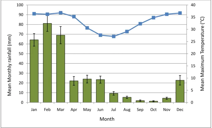
- C LIMATE
- S OILS AND L ANDFORMS
- R EGIONAL V EGETATION AND F LORA
- Regional Vegetation
- Regional Flora
- L OCAL F LORA AND V EGETATION
- Local Vegetation
- Local Flora
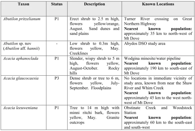
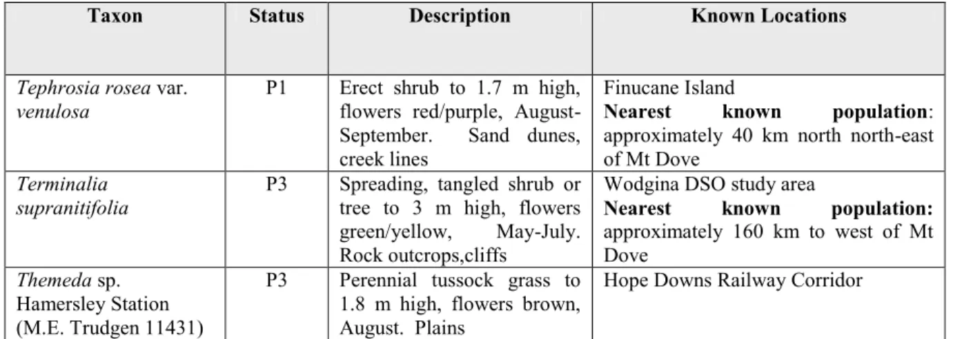
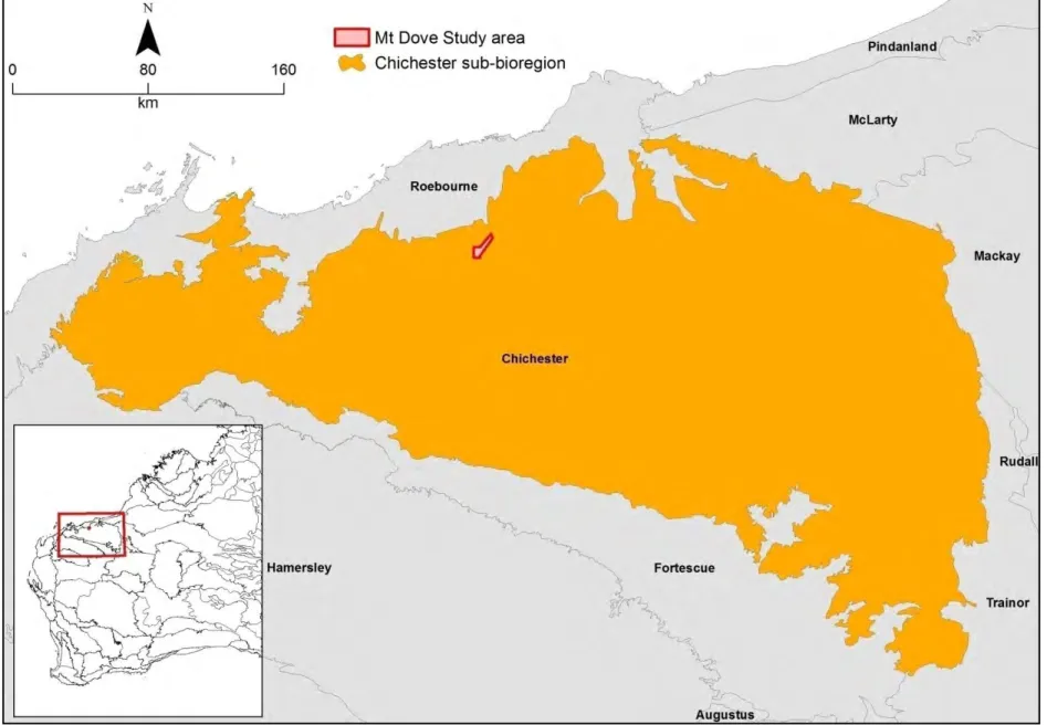
The study area is located in the Pilbara region (Fortescue Botanical District), which is formed from a basement of Archean rocks overlain by massive deposits of Proterozoic sediments and volcanics (Beard 1990). The study area is located within the north-eastern part of the Pilbara IBRA Region (Interim Biogeographical Regionalization for Australia) (Government of Australia 2005), specifically within the Pilbara 1 (PIL1) – Chichester subregion. Declared Rare and Priority Flora list' (regional list), and has no locations in the immediate vicinity of the study area.
Of these, six priority flora taxa are located within or near the study area. A summary of important conservation flora taxa known within or near the study area is shown in Table 3. A summary of introduced or known taxa within or near the study area are listed in Table 4.
METHODS
- A ERIAL P HOTOGRAPHY I NTERPRETATION
- P LANT C OLLECTING L ICENSES
- F IELD S URVEY
- Reconnaissance Survey
- Detailed Survey
- P LANT C OLLECTIONS AND I DENTIFICATIONS
- S TATISTICAL A NALYSIS AND F LORISTIC C OMMUNITY T YPES
- A SSESSMENT OF I MPACTS TO F LORA AND V EGETATION
- Significance of Impact on Flora Taxa
- Significance of Impact on Vegetation
- L IMITATIONS OF S URVEY
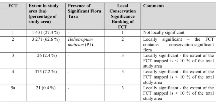
These areas were overlaid on all known locations of conservation significant flora within the study area, and FCT mapping of the study area (Figure 2). The significance of impact on the regional distribution of conservation-significant flora taxa depends on the known range of the taxon throughout the region, in conjunction with previously known records of the taxon either within or near the study area. The significance of the local population/s of the taxon for the regional distribution of the taxon was determined by Table 5.
The local importance of FCTs can be measured by the extent of the FCT within the local area. A detailed survey was conducted in June, at the end of the usual peak flowering season in the Pilbara, with replicate quadrats located in each plant community identified in the study area. Yes - Partial access to the study area was considered appropriate, however limited sampling was undertaken in the central section of the study area (where the proposed access track running southwest from the Great Northern Freeway is located) due to the lack of binaries.

RESULTS
F LORA OF THE S TUDY A REA
- Census of Vascular Flora
- Conservation Significant Flora
- Introduced Flora
Two introduced (weedy) taxa were recorded in the considered area: Aerva javanica and Cenchrus ciliaris. Aerva javanica (Kapok Bush) is a multi-stemmed perennial plant up to 1.6 m tall that prefers sandy soils and is commonly found along drainage channels, sand dunes and floodplains (DEC 2010c) (Table 2). It has a relatively wide distribution throughout Western Australia and is widespread throughout the Pilbara region (DEC 2010d).
It was recorded on the summit and slopes of Mount Dove within two squares on skeletal red-brown sandy loam within FCT 5a (see section 4.2). It was recorded on the summit and slopes of Mount Dove within two squares on skeletal red-brown sandy loam within FCT 5a (see section 4.2), where only isolated plants were noted (Figures 3 and 4). In addition, this taxon was found at three locations outside the study area on nearby hills in FCT 5b (see section 4.2).
V EGETATION OF THE S TUDY A REA
- Floristic Community Types
- Local and Regional Significance of Vegetation
- Vegetation Condition
Vegetation structure often consisted of medium sparse shrubland over low, sparse shrubland over hummock grassland. However, FCT 5 was recorded on several hills west of the study area, albeit as a separate subtype (FCT 5b). Although the extent of TRH FCT 11 has yet to be determined, this FCT (and therefore the corresponding Mt Dove FCT 2) is present outside the Mt Dove study area.
TRH FCT 9 was mapped broadly but sparsely over much of the TRH project study area, on rolling plains and on hillslopes and ridges (Woodman Environmental Report in prep.). Although the extent of TRH FCT 9 has yet to be determined, this FCT (and therefore the corresponding Mt Dove FCT 3) is present outside the Mt Dove study area. Although the extent of TRH FCTs 11, 13 and 15 has yet to be determined, these FCTs (and therefore the corresponding Mt Dove FCT 3) are present outside the Mt Dove study area.
I MPACT ON F LORA
The four squares grouped as FCT 5b as part of the Mt Dove assessment (MD50 - 53) were not grouped into TRH FCT 16, but grouped into TRH FCT 18 (Woodman Environmental Report in preparation). Therefore, it is believed that the vegetation of the hills adjacent to Mt Dove, where these squares were located, is not the same as that on Mt Dove itself. The condition of most vegetation was rated as 'Excellent' or 'Very Good' over most of the study area.
However, for the purposes of vegetation condition mapping, all areas classified as "Excellent" or "Very Good" were mapped as "Very Good", as individual areas frequently assigned different rankings could not be accurately distinguished from each other by aerial photography and FCT. not used. mapping of boundaries (Figure 4). The vegetation on the upper slopes and summit of Mount Dove, which is equivalent to the area mapped as FCT 5a (Figure 3), was classified as "Good". Appendix F provides vegetation condition scale ranking for each quadrat, while Appendix L presents the vegetation condition scale used during the survey (adapted from Keighery 1994).
I MPACT ON V EGETATION
The invasive weed Aerva javanica (Kapok) has established as a dominant component of the shrub layer in this vegetation, and the invasive Cenchrus ciliaris (Buffalo grass) has also been recorded in this vegetation. FCT 5b does not occur in the study area, and therefore no impacts on this subtype will occur. However, there will be a High impact on FCT 5a, with 66.7 % of the range of this subtype within the study area being affected.
The degree of impact on the FCT cannot be considered in a regional context, as no regional data set on Pilbara vegetation is currently available. However, Mt Dove FCT 5a can be considered part of TRH FCT 16 (Woodman Environmental Report in preparation), which is known to occur outside the Mt Dove study area. The extent of this FCT in the entire study area of the TRH project is spatially relatively small (379 ha, 0.6% of the study area of the TRH project), but the FCT is geographically spread throughout the entire study area of the TRH project.
A SSESSMENT OF C LEARING P RINCIPLES UNDER E NVIRONMENTAL P ROTECTION A CT 1986
Principle (c) - native vegetation should not be cleared if it includes or is necessary for the continued existence of rare flora. Principle (d) - Native vegetation may not be cleared if it comprises all or part of it or is necessary for the maintenance of an endangered ecological community. No Priority Ecological Communities (PECs) as listed by DEC (2010f) are known in or near the study area.
The study area is located within the PIL 3 (Chichester) Subregion, of which 100% of the pre-European extent exists (DEC 2007a). Principle (g) – Native vegetation should not be cleared if the clearing of the vegetation is likely to cause appreciable land degradation. Principle (j) – Native vegetation should not be cleared if clearing the vegetation is likely to cause or exacerbate the occurrence of flooding.
F LORA OF THE S TUDY A REA
The study area is located in the central part of Indee Station, which is a privately leased and managed pastoral station. The nearest nature reserve to the study area is located approximately 50 km south-west of Mt Dove (Mungaroona Range Nature Reserve) and Millstream-Chichester National Park is located approximately 110 km west-southwest. Two introduced (weedy) taxa, Aerva javanica (Kapok) and Cenchrus ciliaris (Buffel Grass), were recorded within the study area, exclusively on Dove Mountain itself.
Inspection and cleaning of all machinery and vehicles must be undertaken before entering the study area, to prevent the introduction of weed propagules. Inspection and cleaning of machinery and vehicles must also be undertaken before leaving areas known to have weed infestations within the study area. However, based on quadrat and transect data for the study area, and the uniformity of habit types, it is considered unlikely that populations of conservation-significant and introduced flora will occur elsewhere in the study area, including areas of proposed disturbance.
V EGETATION OF THE S TUDY A REA
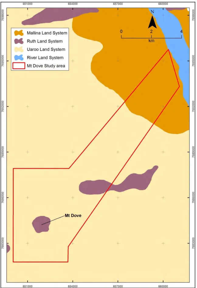
3 Figure 3: The location of the Mt Dove study area in relation to IBRA sub-bioregions. The study area assessed for this proposed rail corridor passes approx. 15 km east of the Mt Dove study area. The study area assessed during this study is located 80 km northeast of the Mt Dove study area.
Being characteristic of the main or important fauna habitats present in the study area; and. A total of 40 bird species were recorded during autumn and spring 2010 surveys in the Mt Dove study area. Six of these species have been recorded in surveys in the vicinity of the study area (Biota 2002b, 2004), while another three have been recorded in the wider surrounding region (Appendix A).
This section summarizes the occurrence of conservation significant vertebrate species that have been recorded or are likely to occur in the study area. The Mt Dove project will impact a small portion (2.3%) of the available suitable habitat within the study area.