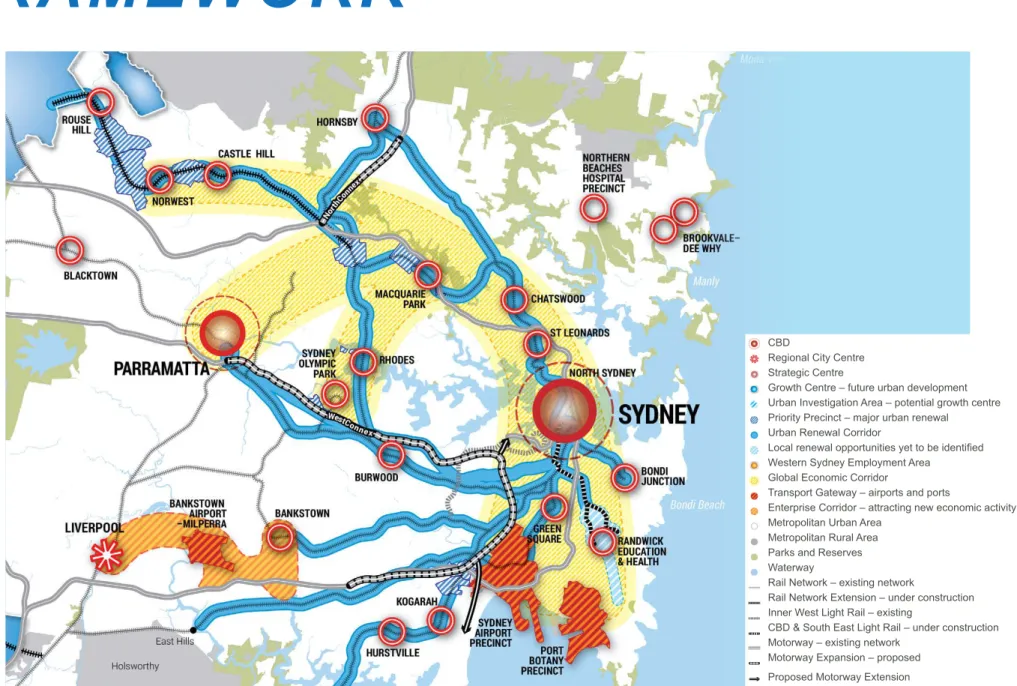
Metro Sydney Northwest is a significant transport project that will improve the liveability of the Hills Shire. As can be seen in Figure 2.1, the delivery of Sydney Metro Northwest will better connect the Shire's strategic centers of Rouse Hill, Castle Hill and Norwest with the wider metropolitan area, unlocking the capacity for economic growth, housing close to jobs and new housing that provides a lifestyle choice.
LOCAL PLANS
THE HILLS DIFFERENCE
While a behavioral change within the community is needed to support the operation of the new public transportation service, planning for housing and employment growth plays an important role in how this change is brought about and delivered. The following section discusses the expected changes in the travel behavior of residents within the rail corridor.
CAR OWNERSHIP
In an effort to achieve a shift from private vehicles to new public transport options, strategies should focus on the quality, reliability, safety and accessibility of the public transport system, rather than a forced reduction of parking for future residents within the corridor. Based on analysis of other major transit hubs within the Sydney Metropolitan Region and consideration of the expected future demographics of the Shire, key assumptions have been developed about how residents' travel behavior may change as a result of the delivery of North West Sydney Metro .
METHOD OF TRAVEL TO WORK
The benefits of changing travel behavior away from car dependence are many and include easing traffic congestion on roads during rush hour.
TRAVEL BEHAVIOUR
- PLACE OF EMPLOYMENT
- THE HILLS RESPONSE
- ACCOUNTABLE AND SUSTAINABLE APPROACH Outcomes are guided by clear evidence that respond
- BALANCE HIGH AND LOWER DENSITY HOUSING Higher density housing is located in areas that have
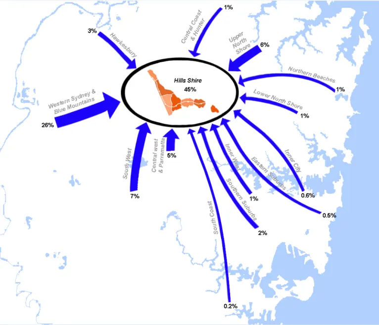
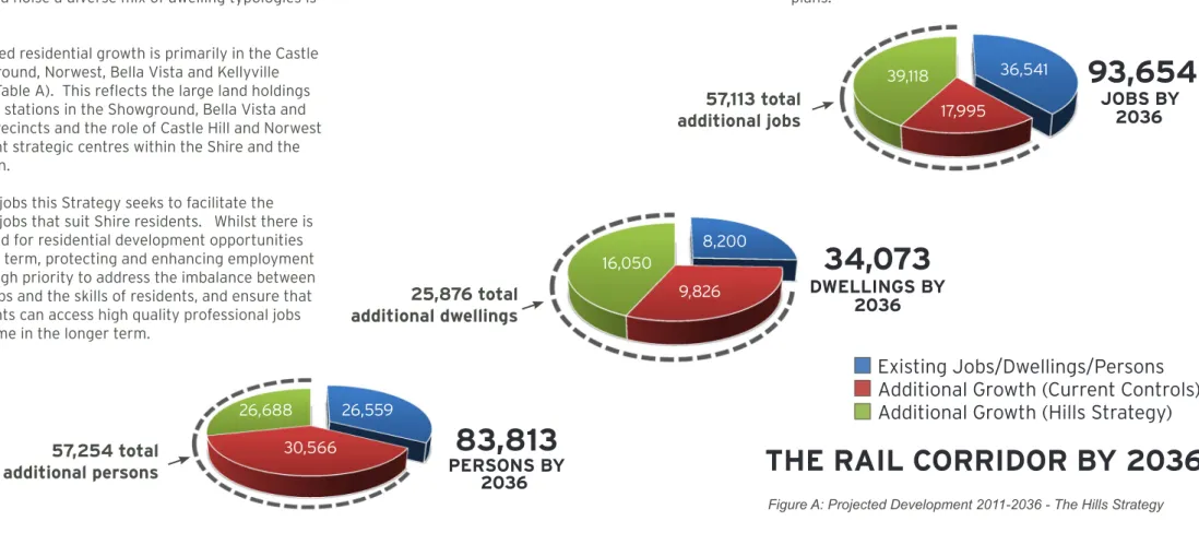
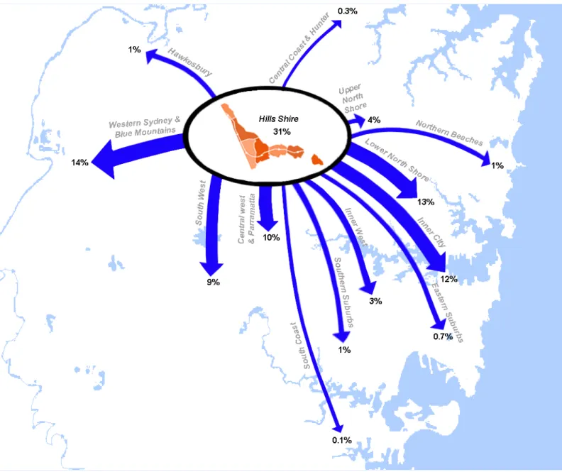
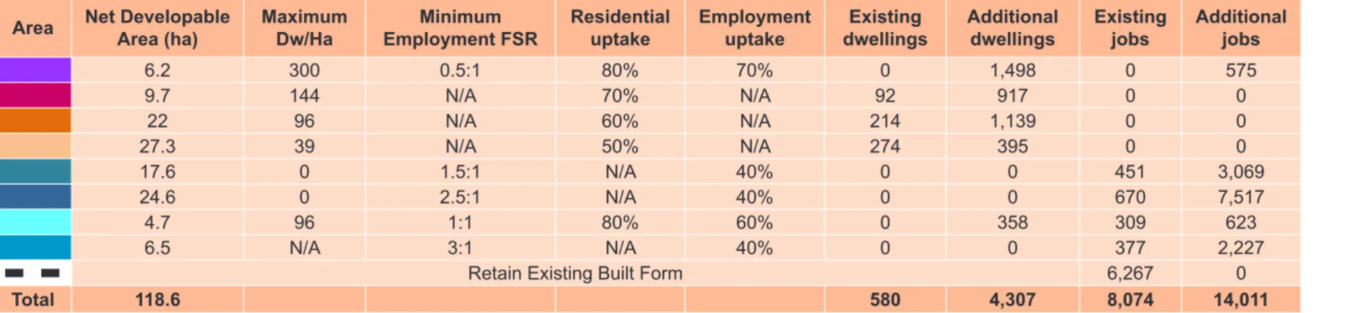
Of the 183,735 people currently living in The Hills Shire, approximately 54% of these people are employed on a full-time, part-time or temporary basis. The main employment opportunities for residents within the Corridor are The Hills Shire (31%), Western Sydney and Blue Mountains (14%), Lower North Shore (13%) and Sydney CBD (12%).
GUIDING PRINCIPLES
- HOUSING TO MATCH SHIRE NEEDS
- FACILITIES TO MATCH SHIRE LIFESTYLE
- JOBS TO MATCH SHIRE NEEDS
- GROW OUR STRATEGIC CENTRES
- APPROACH
- OPPORTUNITES AND CONSTRAINTS
- DESIRED OUTCOMES
- DETERMINING YIELD
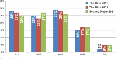
All demographic trends indicate that The Hills Shire remains a family area, which is no surprise given the safety, educational and recreational opportunities available. Currently, the number and range of jobs in the Shire do not match the skills of the majority of residents. As outlined in the Introduction to the Strategy, a number of assessments have been conducted to inform The Hills Strategy, including an assessment of the strategic framework and an assessment of the expected demographic profile.
PRECINCT PLANS
ACHIEVING DESIRED OUTCOMES
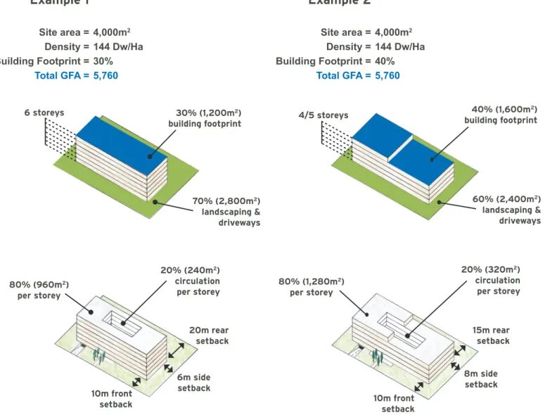
The floor space ratio and 'Building Envelope' controls must be designed and considered together to achieve the desired result of the built form. Where the maximum floor area ratio control does not achieve the full extent of what is possible under the 'building envelope' control (such as achieving the maximum building height), this does not justify exceeding the area ratio control. As shown in Figure 5.3, floor area ratio controls effectively limit the development yield of a site while providing flexibility in built form within the parameters of the 'Building Envelope' control.
CONSTRAINTS Accessibility
CHERRYBROOK PRECINCT
OPPORTUNITIES Accessibility
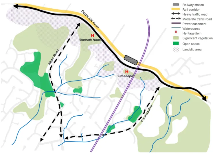
As an established main road, it provides good traffic connections to the east and west. The future Northconnex tunnel, linking the M1 and M2 motorways, can improve accessibility to the north for the county's residents and also reduce traffic on Castle Hill Road. The ridge along Castle Hill Road provides an opportunity for development to take advantage of the county views to the south and offers opportunities for reasonable people.
DESIRED OUTCOMES
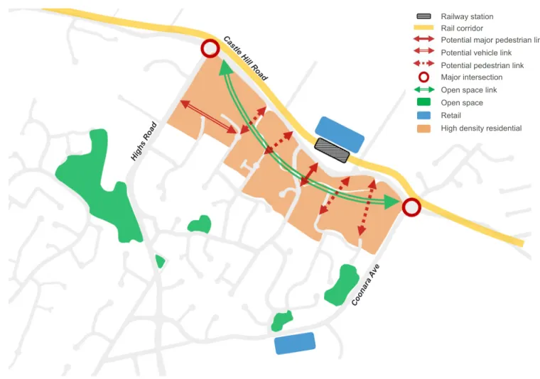
Tall buildings near the station would be located near the top of the hill and cast shadows down the valley. In this particular case, the angle of inclination is reduced from 9º at 9.00 to 2.0. at 3 p.m., when the contours run east-west and the slope smooths out at the angle of the afternoon shadow. Castle Hill Station is a destination station and only a starting point for those who live within walking distance of the station, which should be encouraged.
CONSTRAINTS Accessibility
Castle Hill has been identified as a strategic hub under the 'A Plan for Sydney Growth' signifying its role as an important commercial and business center for the region.
CASTLE HILL PRECINCT
OPPORTUNITIES Accessibility
The area is accessible from three (3) main roads, Old Northern Road from the south, Castle Hill Road from the east and Showground Road from the west. Old Northern Road connects Castle Hill to the CBD via the M2 and major employment centers to the east such as Macquarie Park. Castle Hill already benefits from a ring road around the town center and a bus interchange network to the city centre, Macquarie Park, Parramatta, Norwest and Cherrybrook.
DESIRED OUTCOMES
The Showground Precinct currently contains a number of different land uses such as industrial, residential and commercial. The Showground station area is envisaged to be a mixed destination center with strong public transport links to the city and other centres. It will be developed as a vibrant and active location for employment and housing, with the exhibition grounds and the nearby Fred Caterson Reserve creating a cultural and recreational hub.

CONSTRAINTS Accessibility
Priority areas are areas that are considered to have redevelopment potential on a scale that is important in the implementation of the State's planning objectives. These are larger areas that will be able to deliver significant additional growth, requiring state and local government coordination to realize their potential. The Council will have access to $5 million in local infrastructure funding to support new development.
SHOWGROUND PRECINCT
OPPORTUNITIES Accessibility
There are strong connections to the existing light industrial area along Victoria Avenue, but there are opportunities to improve the precinct's permeability and efficiency with possible new connections to Showground Road. Redevelopment of this district offers an opportunity for waterway restoration and improved access. The redevelopment of land adjacent to the corridor provides the opportunity for these areas to become public open space, with pedestrian and bicycle connections across the creek contributing to increased amenities for workers and residents of the area.
DESIRED OUTCOMES
The Norwest Station Precinct is located within an existing high density commercial business park area adjacent to local shops and low density residential. The Norwest Station Precinct is set to be a major specialist employment hub and become the largest employment hub for the North West. It will feature a commercial core around the station, a retail/mixed-use centre, business park activities to the east and west of the centre, and increased residential density around the employment functions.
CONSTRAINTS Accessibility
NORWEST PRECINCT
OPPORTUNITIES Accessibility
The area will provide opportunities for increased housing and employment within walking distance of the future rail station. As part of the future redevelopment of the Area, there will be opportunities to enhance and increase the permeability of the road network and reduce congestion. Rail delivery and improved accessibility will increase the attractiveness of the business park, providing opportunities to drive investment in businesses and jobs suitable for the Shire's skilled and professional workforce.
DESIRED OUTCOMES
BELLA VISTA PRECINCT
CONSTRAINTS Accessibility
OPPORTUNITIES Accessibility
DESIRED OUTCOMES
KELLYVILLE PRECINCT
- CONSTRAINTS Accessibility
- OPPORTUNITIES Accessibility
- DESIRED OUTCOMES
- CONSTRAINTS Accessibility
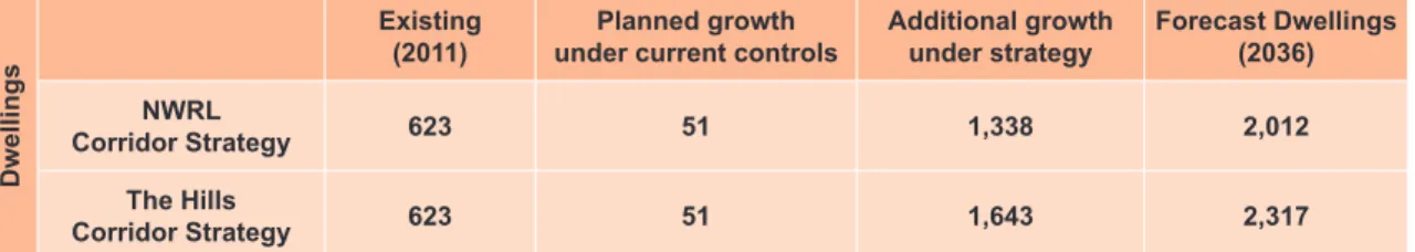
As part of the future redevelopment there will be opportunities to improve the permeability of the road and pedestrian network for better access to the station. A residential density of approximately 168 dwellings per hectare is envisaged in the areas south of the station. Note: The additional growth projected under the NWRL corridor strategy within The Hills Shire part of the Kellyville area is less than what can be achieved under current controls.
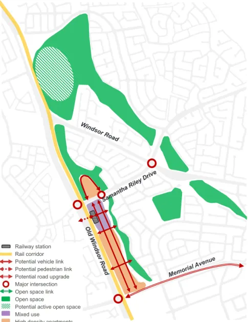
ROUSE HILL PRECINCT
OPPORTUNITIES Accessibility
The area is well served by footpaths and cycleways along Windsor Road to the north and south, Schofields Road to the west and low-density residential areas to the north-east of the precinct via an open corridor linked to Caddies Creek. There is an open space corridor connected to the Caddies Creek riparian corridor that can be used for a passive open space/bike path. This open space corridor links into a wider greenway/open space corridor link that runs from Rouse Hill in the north to Bella Vista and Baulkham Hills in the south.
DESIRED OUTCOMES
The additional population due to future development within the railway corridor will increase the demand for various public facilities and services. Increased demand for local active and passive leisure facilities, such as playing fields, playgrounds and greenway links;. Increased demand for facilities that will support safe and convenient travel such as new roads and public transport facilities; and.

OPEN SPACE AND RECREATION FACILITIES This section considers the open space and recreational
Local open space and community amenities are important to residents' daily lives and will help people feel connected to their local community. Increased demand for water cycle management facilities due to the additional stormwater runoff generated by impermeable surfaces associated with urban development. This includes identifying opportunity locations where the additional demand for active open space could be met, as well as an indication of preferred locations for neighborhood and neighborhood parks and community facilities.
INFRASTRUCTURE
COMMUNITY FACILITIES AND SERVICES The future residents within the corridor will generate
It is noted that the calculation of the number of primary schools is based on the infrastructure standards prepared by the Growth Center Commission (2006). While the provision of aged care facilities is essential, it is considered that this service can be provided by the market more cost effectively. In addition to this, there would also be a need for approximately five long daycare centers. childcare places is critical, but it is considered that this service can be provided by the market more cost-effectively.
TRAFFIC AND TRANSPORT
Therefore, the housing yields identified in this strategy are the maximum yields envisaged within the corridor and infrastructure requirements have been considered on this basis. It is further assumed that the maximum yields identified in this strategy will be achieved only where. Accordingly, further detailed studies will be completed in the preparation of local controls such as floor area ratios and building envelope controls to determine appropriate built form on specific land within each area which would achieve the benefits envisaged in this strategy whilst delivering appropriate built form results within the context of each area.
LOCAL ENVIRONMENTAL PLAN
It sets out the Council's position on how the areas surrounding the station should be developed in the future. Notwithstanding this, it is assumed that these maximum residential yields will only be achieved where future development meets the specific design and development criteria set out by the Council (including compliance with the Council's controls in relation to the mix and size of apartments and car parking). . To achieve this, it is envisaged that future planning controls under the 2012 LEP will be designed to allow for partial land density increases within station areas, with the maximum increase envisaged under this strategy only available for development which facilitates the distribution of apartments . which meet the needs and expectations of Hills Shire residents and suit the family demographics expected for the Shire in the future.
IMPLEMENTATION
DEVELOPMENT CONTROL PLAN
Controls will be in place to ensure that future development contributes to the desired future character that promotes site consolidation, optimizes solar access, respects open space and takes a conscious design approach that is attentive to orientation and sensitive interfaces. Building envelope controls such as setbacks, landscaped areas and storey heights will be important in achieving built form outcomes and will need to be considered in partnership with floor proportion controls. Site-specific controls will be in place to achieve a well-connected road and pedestrian network, active street frontages, high-quality architectural style and character, attractive streetscapes and public space, and shared open space within developments that enhance the quality of life for residents.
INFRASTRUCTURE PLAN
STRATEGIC PROJECTS
Stormwater Management, Landy Place, Kellyville T-Way Underpass, Windsor Road, Bella Vista Rouse Hill Bus Stop. Castle Hill Shopping Center and Towers Norwest Business Park and Bella Vista (viewing east) Castle Hill Exhibition Centre, Castle Hill shopping precinct and surrounds (viewing west). Bella Vista and Norwest Business Park (View East) Beaumont Hills, Kellyville and Surroundings (View South) Rouse Hill Town Center.
APPENDIX
Cherrybrook Projected Dwellings Cherrybrook Projected Dwelling Yields Kellyville Projected Dwellings Kellyville Projected Jobs Kellyville Projected Yields Rouse Hill Projected Dwellings Rouse Hill Projected Jobs Rouse Hill Projected Yields. Necessary transport infrastructure in Cherrybrook Necessary transport infrastructure in Castle Hill Necessary transport infrastructure in Showground Necessary transport infrastructure in Norwest Necessary transport infrastructure in Bella Vista Necessary transport infrastructure in Kellyville Necessary transport infrastructure in Rouse Hill. Norwest Opportunities Norwest Desired Outcomes Bella Vista Station Catchment Bella Vista Constraints Bella Vista Opportunities Bella Vista Desired Outcomes Kellyville Station Catchment Kellyville Constraints Kellyville Opportunities Kellyville Desired Outcomes Rouse Hill Station Catchment Rouse Hill Constraints Rouse Out Hill Deportired Rousecom.