Abrolhos state marine territorial waters (below the high water mark up to three nautical miles) are managed by the Department of Primary Industries and Regional Development (DPIRD) as the Houtman Abrolhos Islands Fish Habitat Protection Area (Abrolhos FHPA). Maintain and expand reporting of commercial and recreational activities and associations within the Abrolhos FHPA.
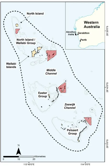
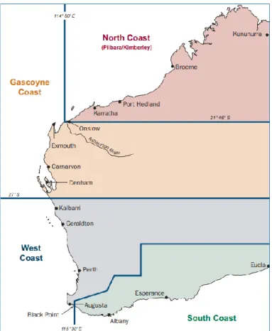
Houtman Abrolhos Islands
Likewise, the fish fauna of the Abrolhos is influenced by its unique ecosystem with a survey conducted by WA Museum reporting up to 389 species of which 66%. 321 | Although rich in natural values, maritime history (Edwards, 1989; Green, 2020), early industrial development (e.g. guano mining) and continuous commercial fishing (e.g. western rock lobster) (Stanbury, 1993; Bertelsen, 2009), up to to date, significant permanent tourism-based development or infrastructure (either land or marine) has not occurred at the Abrolhos.
State Land and Water Management Arrangements
The Abrolhos FHPA has significant economic and social value for commercial and recreational fishing, aquaculture and tourism. 321 | For over 20 years, the Abrolhos FHPA has been managed under an adaptive legislative framework for the protection and sustainable management of this unique marine environment in collaboration with significant and valuable stakeholders (e.g. commercial and recreational fisheries, aquaculture and fishing tour operators).
West Coast Rock Lobster Managed Fishery
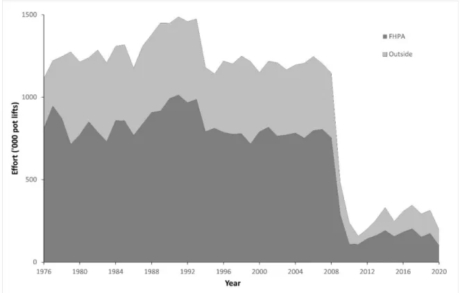
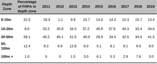
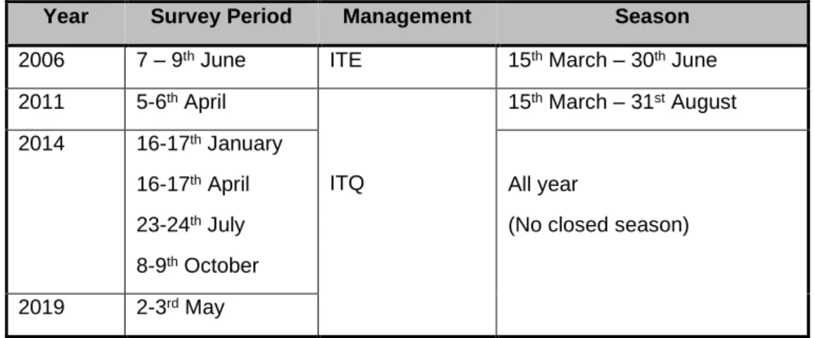
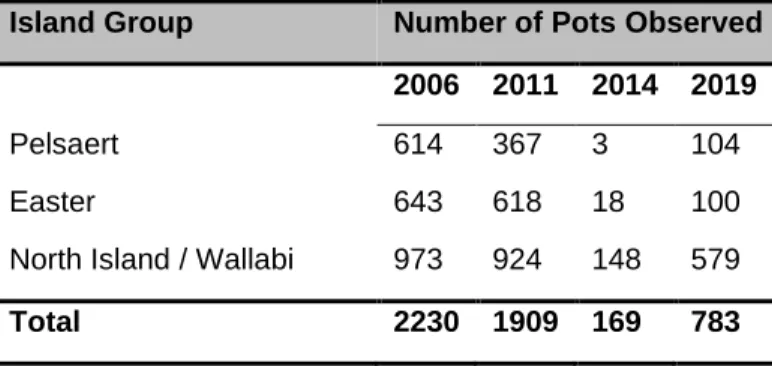
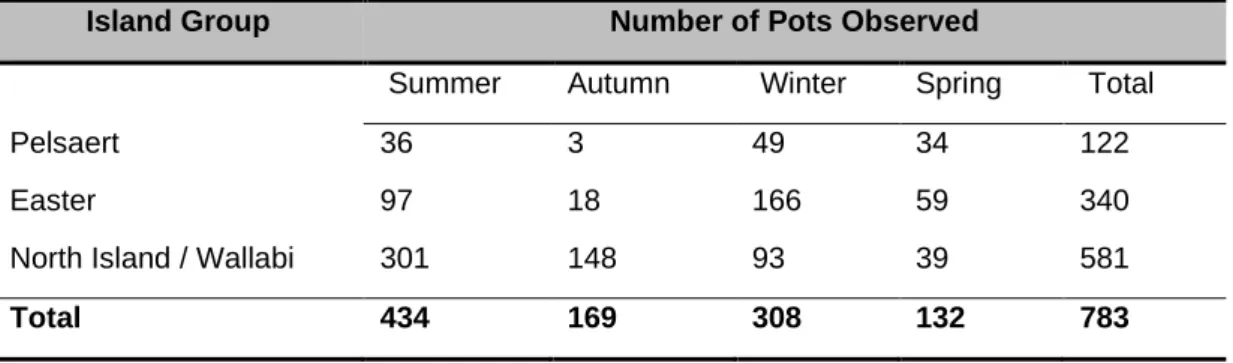
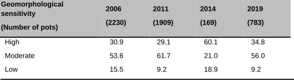
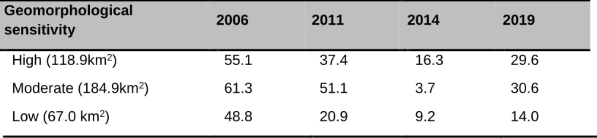
Annual WCRLMF A Zone total fishing effort (potlifts) relative to effort estimates within (bottom) and outside (top) of the Abrolhos FHPA. Spatial distribution and intensity of WCRLMF fishing activity (aerial pot counts) during the historic fishing season (March to June) on the shallow (<20m) waters of the Abrolhos FHPA.
Abrolhos Islands and Mid-West Trawl Managed Fishery
Within the Abrolhos FHPA, scallops are generally found on the sandy bottoms on the leeward side of the islands (Chandrapavan et al., 2020). It is recognized that this method of proportioning the effort within or outside the Abrolhos FHPA is a general estimate.
West Coast Demersal Scalefish (Interim) Managed Fishery
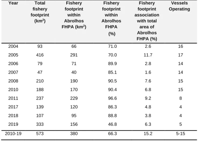
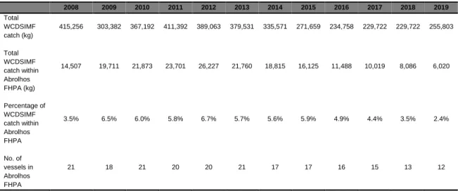
The WCDSIMF catch data (live weight - kg) were extracted for each of the 17 data blocks (which had 3 or more operators) that fell within or intersected the Abrolhos FHPA boundary. The block encompassing North Island had the highest total catch within the Abrolhos FHPA (10,300 kg) (Figure 2.3.4). There were 87 species (or species categories) landed by the WCDSIMF within the Abrolhos FHPA across all years of data.
Number of species (and species categories) recorded as WCDSIMF catch from the 17 data blocks associated with the Abrolhos FHPA. Explore the potential for WCDSIMF catch and effort reporting specific to fishing activity within the Abrolhos FHPA.
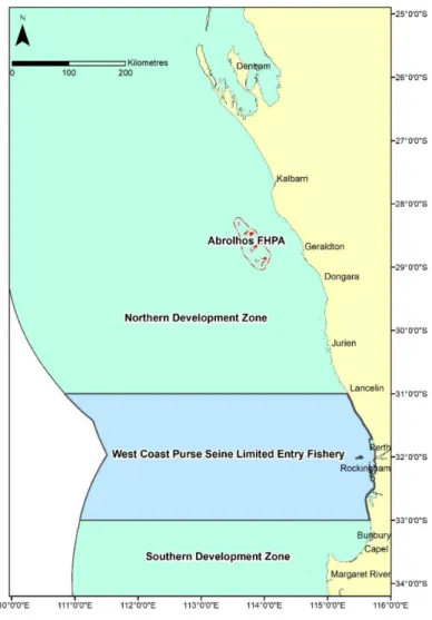
West Coast Purse Seine Fishery
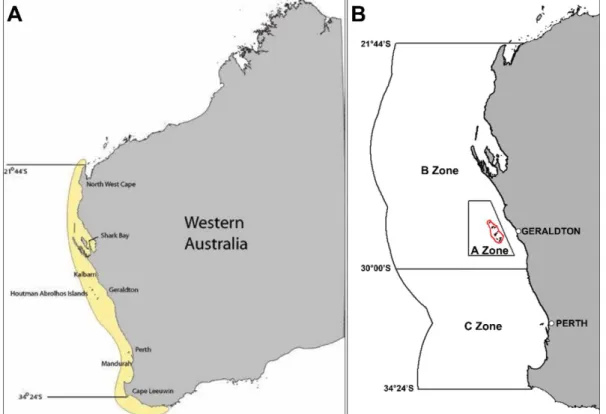
Maintain regular updates of WCDSIMF fisheries activity associations with Abrolhos FHPA aquatic resources and other users (eg commercial fisheries, aquaculture, recreation and tourism). 321 | Page 61 north (to the Northern Territory border) with the Northern Development Zone including the entire Abrolhos FHPA (Figure 2.4.1). Currently, there are several spatial closures (eg, ROAs) within the Abrolhos FHPA that apply to the WCPSF.
For confidentiality reasons, historical catch and effort data are therefore not available for association with the Abrolhos FHPA. Maintain regular updates of WCPSF fishing activity associations with Abrolhos FHPA aquatic resources and other users (eg commercial fishing, aquaculture, recreation and tourism).
Mackerel Managed Fishery
There are currently several spatial closures (eg ROA) within the Abrolhos FHPA that apply to SDT. Catch data from the remaining data blocks within SDT Area 3 were considered outside the Abrolhos FHPA. For confidentiality reasons, catch data related to the Abrolhos FHPA and MMF Area 3 are reported as cumulative totals for the years 2006 to 2019.
The remaining Abrolhos FHPA catch of ~0.5 t (1.4%) contained spotted mackerel (Scomberomorus munroi), yellowfin tuna (Thunnus albacares), gray mackerel (Scomberomorus semifasciatus) and shark mackerel (Grammatorcynus bicarinatus). Explore the potential of MMF fishery bycatch and ETP reporting specific to the Abrolhos FHPA.
Marine Aquarium Fish Managed Fishery
Similarly, annual catch data was reported for 2015 to 2019 in the Abrolhos FHPA in comparison to the total statewide MAFMF catch. Cumulative catch data from 2010-2019 show that the Abrolhos FHPA accounts for a significant portion of the total MAFMF soft coral catch (28.9%), 'living rock'. Two invertebrate categories and one soft coral species can be reported using the publicly available data for the Abrolhos FHPA.
Annual proportion (%) of total MAFMF catches (2015-19) and 10-year cumulative catch (2010-19) of primary target invertebrate and soft coral species from within the Abrolhos FHPA. Investigate the assessment of relative abundance of bubble point anemone and other target species categories in relation to the Abrolhos FHPA.
Specimen Shell Managed Fishery
Between 2010 and 2019, six licensees reported catches and effort from the Abrolhos FHPA data blocks, representing 21.4% of the 28 licenses reporting effort across the entire SSMF for the same period. Cumulatively, a total of 226 individuals were captured from the Abrolhos FHPA, representing ~0.2% of the total SSMF capture. The main specimen shells targeted at the Abrolhos FHPA are of the family Cypraeidae (cowries) and a small portion of the family Volutidae (volutes).
In all but one year, fewer than three licenses reported catches and effort from the blocks associated with the Abrolhos FHPA and therefore detailed annual comparisons could not be made. During the only year data could be reported, 0.6% of the total SSMF catch came from the Abrolhos FHPA.
Octopus Interim Managed Fishery
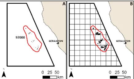
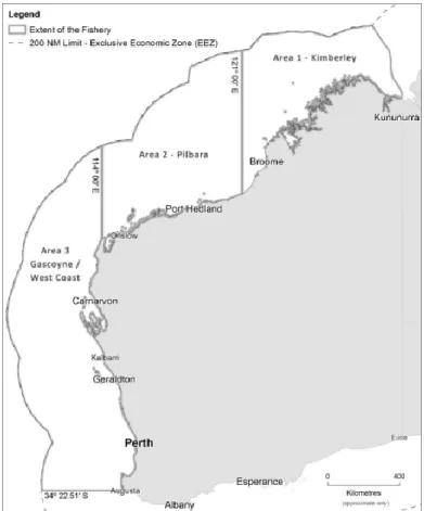
For this report, OIMF data is based on DPIRD source data, where catch (live weight in kg) and effort (fishing days) data related to the Abrolhos FHPA were collected for the 17 data blocks (DPIRD, 2020c) that either completely fall within cut the Abrolhos FHPA boundary or it (Figure 2.2.1B). Where available (eg reported by 3 licenses or more), data were reported specific to the Abrolhos FHPA and compared to Zone 1 and the OIMF statewide totals. It is recognized that the proportion of catch and effort within the Abrolhos FHPA from data blocks that cross the boundary (i.e. effort can be inside or outside) may overestimate catch and effort from the OIMF within the Abrolhos FHPA.
Investigate the potential of OIMF for fisheries bycatch and ETP reporting specific to the Abrolhos FHPA. Investigate the merits of OIMF spatial closures, particularly in areas identified as highly sensitive or with potential resource allocation mismatches in the Abrolhos FHPA.
Abalone Managed Fishery
Maintain regular updates of OIMF fishing activity associations with Abrolhos FHPA water resources and other users (eg, commercial fishing, aquaculture, recreation and tourism). For this report, AMF data were based on DPIRD source data, where catch (live weight in kg) and effort (fishing days) were aggregated in the Abrolhos FHPA for the 17 data blocks (DPIRD, 2020c) that either fall entirely within the Abrolhos FHPA boundary or cut it (Figure 2.2.1B). No catch or effort data have been reported by the Abrolhos FHPA to the AMF from 1990 onwards.
Note - 1990 was chosen as an arbitrary time point, approximately 30 years ago, to review the original DPIRD data for the Abrolhos FHPA effort for this fishery. Maintain regular updates of linkages of AMF fishing activities with Abrolhos FHPA water resources and other users (e.g. commercial fishing, aquaculture, recreation and tourism).
Fishing Tour Operator Industry
The annual number of tour operator licenses that have been declared in the WCMZ and the Abrolhos FHPA. Spatial distribution of cumulative fishing effort (trips) by tour operators affiliated to the Abrolhos FHPA between 2002 and 2020. Spatial distribution of cumulative fishing effort (trips) by tour operators affiliated to the Abrolhos FHPA between 2016 and 2020.
The number of fish kept from the Fishing Tour Operator Industry of the Abrolhos FHPA was generally. Annual compilation of the seven most common fish species (fins and invertebrates) by the Fishing Tour Operators within the Abrolhos FHPA.
Aquaculture
The MWADZ, which appeared in the Government Gazette in 2017, has the two largest licensed aquaculture sites in the Abrolhos FHPA (Figure 2.11.1). Aquaculture products farmed in the Abrolhos FHPA have expanded to also include sponges, coral, live rock, algae and finfish. Aquaculture licenses at the Abrolhos FHPA have steadily increased since the first license and site was granted in 1996.
As of December 2021, four additional aquaculture license applications are being evaluated for the Abrolhos FHPA. Review aquaculture activities in the Abrolhos FPHA, in relation to the Houtman Abrolhos Aquaculture Plan and the Draft Abrolhos FHPA Management Plan (2022).
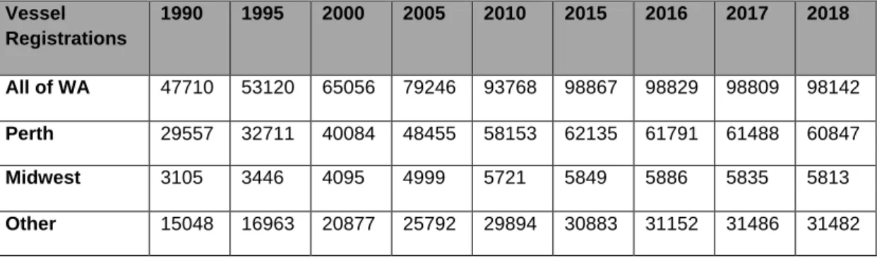
Recreational Vessel Accessibility to the Abrolhos FHPA
Data collected in the VNS captures the intent of the Master when entering the Abrolhos FHPA. The timing of visits for private leisure / tourism activities to the Abrolhos FHPA is variable throughout the year. This result is expected for the Midwest, given the Abrolhos FHPA's proximity to the region.
Proportion (%) of all communications which visited specific archipelagos in the Abrolhos FHPA between 2018 and 2021. The Midwest zone encapsulates the Abrolhos FHPA and the 2017/18 survey estimated the retained catch (as individuals) for the most commonly caught species to be: WRL (90,558), baldchin.
Coral Reef Health Monitoring
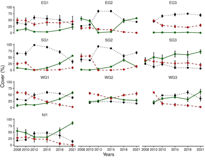
Benthic environment composition (percent cover) of three broad benthos categories for the Abrolhos FHPA reef monitoring program between 2008 and 2021. Benthic environment composition (percent cover) of three broad benthos categories for ten individual program sites of Abrolhos FHPA reef monitoring between 2008 and 20 Overall, the DPIRD Abrolhos FHPA reef monitoring program has identified thirty-five hard coral genera (see Appendix A).
Benthic environmental composition (percentage cover) of specific hard coral and algal genera categories for the Abrolhos FHPA reef monitoring program between 2008 and 2021. Maintain the Abrolhos FHPA hard coral reef monitoring program to inform long-term ecological trends.
Hard Coral Recruitment
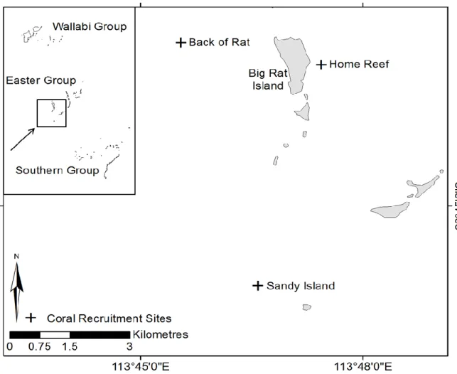
This may be of further importance for high-latitude reefs where macroalgal increases, as seen at the Abrolhos FHPA following the 2010/11 WA marine heat wave (section 4.1 of this report), and low recruitment levels of hard corals may limit the capacity of these reefs. to recover (Hoey, 2011). To understand these conditions at the Abrolhos FHPA, in February 2011 DPIRD began a seven-year study to examine the recruitment levels of corals in the Easter group. Recruitment was also highly variable between years (Figure 4.2.2), supporting the theory that localized broadcast spawning at high latitudes, such as the Abrolhos FHPA, is not consistent.
Investigate the need for a new three-year study to examine hard coral recruitment in the Abrolhos FHPA. Investigate factors that may influence large-scale hard coral recruitment patterns in the Abrolhos FHPA.
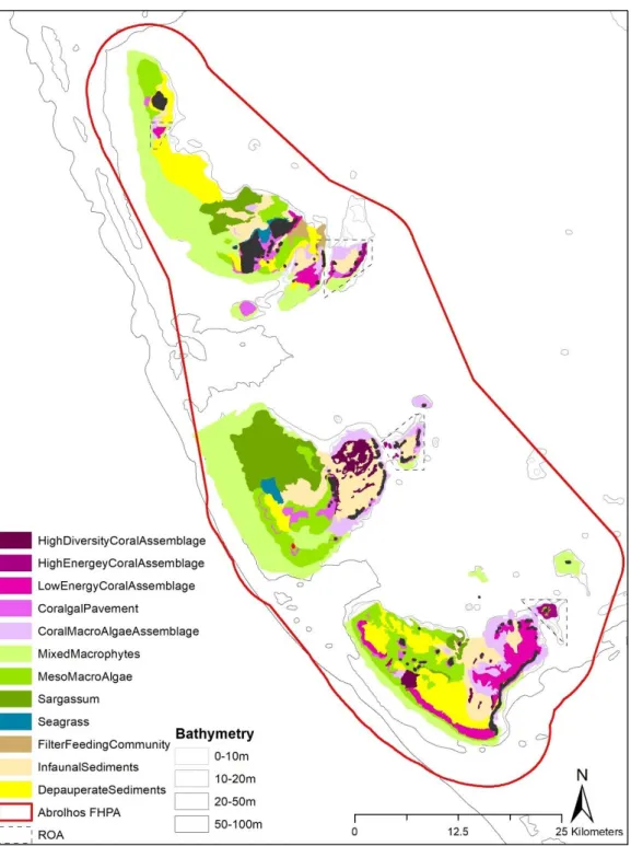
Habitat Mapping
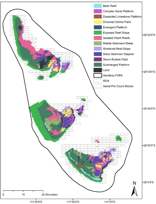
Prioritize the development of continuous habitat mapping and monitoring (at an appropriate scale) of the Abrolhos FHPA to support fisheries, aquatic resources and ecosystem management.
Relative Abundance of Key Target Demersal Finfish Species – Long
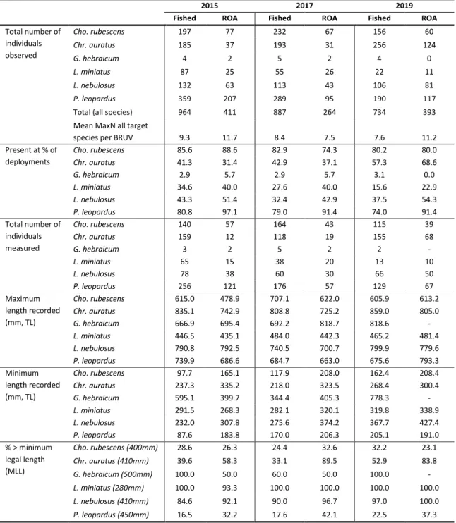
The increase in mean MaxN between 2010 and 2013 was observed in all target species, but higher in the tropical species P. 321 | At all sites examined in the Abrolhos FHPA, the mean length of all measured target species (excluding G. hebraicum) was observed to increase between 2013 and 2019 (Figure 4.4.7). Average total length (TL) for five target species (excluding G. hebraicum due to low number of observations) at all Abrolhos FHPA BRUV sites between 2013 and 2019.
When examined by conservation status, mean length for all target species measured was shown to be higher in the ROAs between 2013 and 2019 (Figure 4.4.8). Length distribution (core density estimate) between fished (dark grey) and ROA (light grey) areas for five target species between 2013 and 2019.
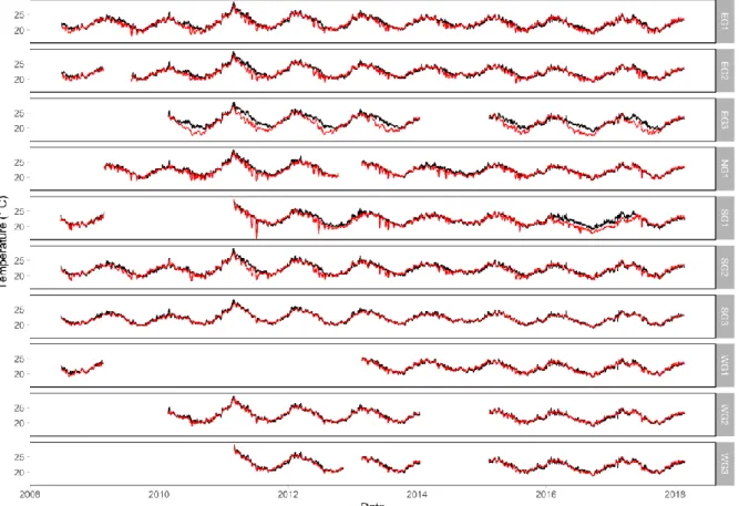
Environmental Data
In: Status reports of the fisheries and aquatic resources of Western Australia 2019/20: The State of the Fisheries eds. An overview of the governance arrangements and licensing framework for the water tourism industry in Western Australia. In Status reports of the fisheries and aquatic resources of Western Australia 2019/20: The State of the Fisheries eds.
Status report of the fisheries and aquatic resources of Western Australia 2019/20: The state of the fisheries. A preliminary report on the interaction between major human activities and the marine environment of the Houtman Abrolhos Islands of Western Australia.