This Preliminary Environmental Impact Study describes the existing environment of the project area and surrounds and examines the resulting potential impacts of the project in relation to its construction and physical presence. Quenda are likely to use some areas of the project area for foraging, but the project area does not contain habitat for this species. The northern part of the project area is within a Priority 3 Public Drinking Water Source Area in terms of the Jandakot Ground Water Pollution Control Area.
The land use east of the project area is predominantly privately owned and includes residential areas and a retirement community. The aim of the proposed project is to improve the existing amenities in residential areas adjacent to the Kwinana Freeway. This PEIA includes the MRWA Vegetation Clearing Impact Assessment Report which assesses the proposed project against Schedule 5 of the Environmental Protection Act 1986 (EP Act) Ten Clearing Principles (Appendix A) and makes recommendations for the proposed project as a result of this PEIA ( Appendix B) ).
Methodology
Preliminary desktop assessment
Site investigation
Referral
Environmental Factors
Matters of national environmental significance
Reserves and conservation areas
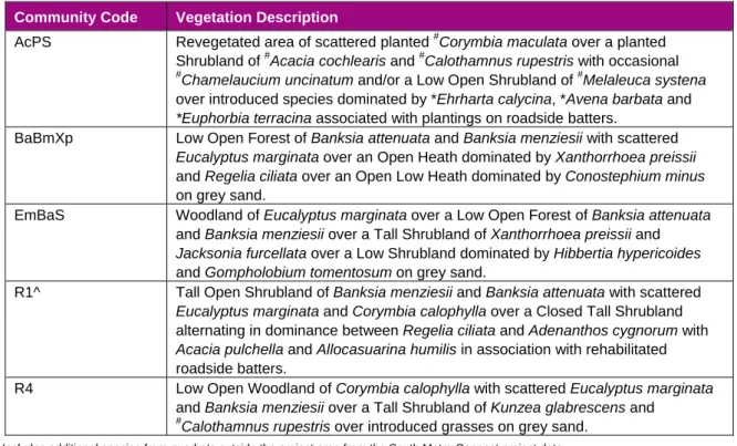
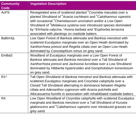
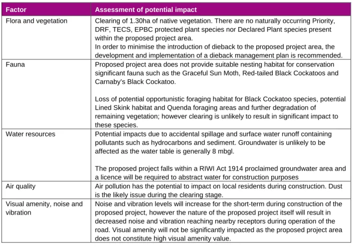
Flora and vegetation
Vegetation representation and condition
Amenity Wall
Threatened and priority ecological communities
A recent search of DEC's Threatened Ecological Communities (TEC) database did not find any TEC occurrences in the proposed project area. In addition, no TECs or priority ecological communities (PECs) were recorded during a field survey of the southern extension of the Kwinana Freeway in 2010 (AECOM 2010). A search of the DSEWPaC Protected Matters Database (Appendix C) also did not identify any likely TEC occurrences protected under the EPBC Act.
The vegetation of the southern Swan Coastal Plain has been classified into FCTs and has been documented in Gibson et al. The species composition of the intact vegetation communities recorded from the Kwinana Freeway Southern Extension field survey was analyzed and compared to the dataset of Gibson et al., (1994) and FCTs are derived from this (AECOM 2010). None of the recorded vegetation types within the proposed project area have been identified as equivalent to FCTs classified as TECs or PECs.
Declared rare flora
The main tool for classifying the vegetation of the Swan Coastal Plain to determine equivalence with TECs is the designation of Floristic Community Types (FCT).
Introduced flora
Seventy-one introduced (weed) species were recorded during the Kwinana Freeway Southern Extension field surveys; this includes six planted non-locally endemic species (AECOM 2010). Of these seventy-one introduced species, three are listed as declared plants by DAFWA under the Agriculture and Related Resources Protection Act, 1976. The required control measures for the registered declared plants are available on the DAFWA website (www.agric.wa.gov.au).
The indicated plant species recorded during the Kwinana Freeway Southern Extension field survey were not recorded as being present in the Kwinana Freeway Amenity Wall project area.
Dieback and other diseases or pathogens
Fauna
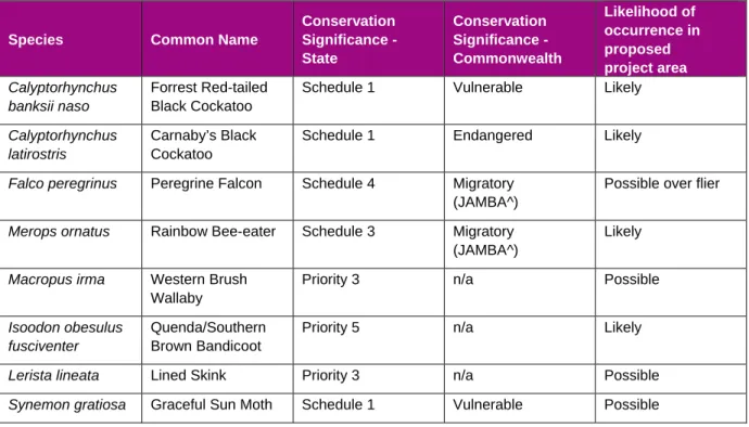
A potential sun butterfly may occur in the proposed project area as the area supports populations of Lomandra hermaphrodita (AECOM 2010; Phoenix 2010). However, the light sun butterfly is unlikely to be found in the proposed project area, as the potential habitat patches are too small to represent suitable habitat, according to DEC advice (D Mitchell personal communication 2011). This species is associated with Banksia woodland (Bush et al. 1995) and is likely supported by the BaBmXp and EmBaS plant communities within the proposed project area.
The DEC Threatened Fauna Database identified a previous record of Quenda within the proposed project area (Figure 3). The Kwinana Freeway Southern Extension survey area identified two wetland vegetation communities that provide suitable habitat for Quenda; however, the proposed project area does not include these vegetation communities. Quenda was not observed directly during the field assessment, but is likely to use some areas within the proposed project area (AECOM 2010).
Water resources
- Public drinking water source area
- Surface waters and wetlands
- Groundwater
Geology, landforms and soils
Contamination
Non-indigenous heritage
Aboriginal heritage
Adjacent land use
Climate
Air quality
Visual amenity
Potential Impacts
Matters of national environmental significance
Flora and vegetation
- Clearing of native vegetation
Fauna
Water resources
- Public drinking water source area
- Surface waters and wetlands
- Groundwater
Geology, landforms and soils
Contamination
Climate
Air quality
Visual amenity, noise and vibration
Summary of key aspects and impacts
There are no naturally occurring priority, DRF, TECS, EPBC protected plant species or notified plant species in the proposed project area. In order to minimize the input of dieback to the proposed project area, the development and implementation of a dieback management plan is recommended. Fauna The proposed project area does not provide suitable breeding habitat for conservation-important fauna such as the lovely sunbirds, red-tailed black cockatoos and Carnaby's black cockatoos.
Loss of potential opportunistic foraging habitat for Black Cockatoo species, potential Lined Skink habitat and Quenda foraging areas and further degradation of. Water resources Potential impacts due to accidental spills and runoff of surface water containing pollutants such as hydrocarbons and sediments. The proposed project falls within a declared groundwater area of the RIWI Act 1914 and a license will be required to extract water for construction purposes.
Noise and vibration levels will increase for the short term during construction of the proposed project, but the nature of the proposed project itself will result in reduced noise and vibration reaching nearby receptors during the operation of the road. Visual amenity will not be significantly affected as the proposed project area does not constitute high visual amenity value.
Requirement for Referral
Conclusions and Recommendations
MRWA Vegetation Clearing Impact Assessment Report
Area Under Assessment Details
Proponent details
Property details
Area under assessment
Avoidance/Minimise clearing
Background
Existing environment and information
Assessment of application against Clearing Principles
- Planning instrument, Native Title, RIWI Act Licence, EP Act Licence, Works Approval, Previous EPA decision or other matter
The condition of community types in the project area varies from good to deteriorated, with most of the project area in good condition. Includes additional types of squares outside the project area from the South Metro Connect project data. Two of the five vegetation communities found in the project area represent revegetated land and the remaining native vegetation is considered to have moderate biological diversity with a high proportion of weeds.
A search of DEC's threatened and prioritized flora database found one priority 5 flora species within the project area; no naturally occurring species of priority flora or Declared Rare Flora (DRF), listed by DEC under the Wildlife Conservation Act 1950, or threatened species under the EBPC Act were recorded during the Kwinana Freeway Southern Extension field survey (AECOM 2010). A recent search of DEC's Threatened Ecological Communities (TEC) database found no occurrences of TECs within the project area. None of the recorded vegetation types within the project area have been determined to correspond to FCTs classified as TECs or PECs.
The project area is considered a restricted area due to its urban zoning; however, according to this objective, it is not considered underrepresented. The project area does not contain and is not adjacent to any significant lakes, rivers, wetlands or proclaimed areas. The nearest Ramsar listed wetland (Forrestdale and Thomson Lake) is approximately 22 km south of the project area.
3.1.1.6 (g) Native vegetation shall not be cleared if clearing of vegetation is likely to cause significant soil degradation. 3.1.1.7 (h) Native vegetation shall not be cleared if the clearing of the vegetation is likely to have an impact on the environmental values of an adjacent or nearby protected area. 3.1.1.8 (i) Native vegetation shall not be cleared if the clearing of vegetation is likely to cause a deterioration in the quality of surface or ground water.
The topography of the project area is relatively flat with a slight slope to the west, which reduces the likelihood of high velocity surface water flow.
Assessor’s recommendations
OFFICER PREPARING REPORT
PEIA RECOMMENDATIONS – RECOMMENDATION ACTION REPORT
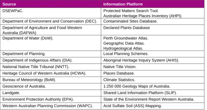
This report provides general guidance on matters of national environmental interest and other matters protected by the EPBC Act in the area you have selected. Information about the coverage of this report and qualifications about data supporting this report are contained in the caveat at the end of the report. You may want to print this report for reference before moving on to other pages or websites.
Information on the EPBC Act, including significance guidelines, forms and details on the application process, can be found at http://www.environment.gov.au/epbc/assessmentsapprovals/index.html.
Report created: 16/02/11 14:51:31
Protected Matters Search Tool
This section of the report summarizes matters of national environmental importance that may arise in or be related to your nominated area. More information is available in the detail section of the report, which can be accessed by scrolling or following the links below. If you intend to undertake an activity that may have a significant impact on one or more matters of national environmental importance, you should consider the Administrative Guidance on Significance - see.
This section of the report summarizes other matters protected by law that may relate to the area you have proposed. Approval may be sought for a proposed activity that has a significant effect on the environment in a Commonwealth territory where the action is outside the Commonwealth territory, or on the environment anywhere where the action is carried out in a Commonwealth territory. Approval may also be required for the Commonwealth or Commonwealth agencies proposing action that is likely to have a significant effect on the environment anywhere.
The EPBC Act protects the environment in Commonwealth territories, the environment from measures taken in Commonwealth territories and the environment from measures taken by Commonwealth agencies. Commonwealth heritage values of a Commonwealth heritage place and heritage values of a place on the National Property Register. Additional information on Commonwealth land should be obtained from appropriate sources, including Commonwealth agencies, local agencies and land tenure maps.
A permit may be required for activities in or on a Commonwealth territory that involve a member of a listed threatened species or ecological community, a member of a listed migratory species, whales and other cetaceans, or a member of a listed marine species can affect. Information on EPBC Act permit requirements and application forms can be found at http://www.environment.gov.au/epbc/permits/index.html. This part of the report provides information that may also be relevant to the area you have nominated.
Details
Matters of National Environmental Significance
Wetlands of International Significance (RAMSAR Sites)
BIRDS
INSECTS
Migratory Marine Birds Apus pacificus
Other Matters Protected by the EPBC Act
Birds
Extra Information
Natural
Mammals Felis catus
Caveat
Coordinates
Acknowledgements