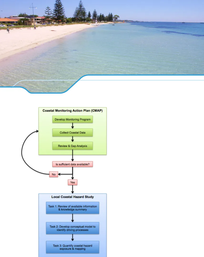
The objective of a local coastal risk assessment is to predict and quantify the coastal exposure to erosion and flooding in detail. The assessment is limited to a relatively small area or location where active short-term (<25 years) adaptation and management is or is likely to be required. Where appropriate, this study is expected to build on existing coastal zone monitoring information and the results of existing Coastal Hazard Risk Management and Adaptation Planning (CHRMAP).
This standard range is only a guide and should be adjusted to meet the individual needs of the user. Coastal hazard assessment can be undertaken at a variety of scales, depending on their purpose and the level of definition required. The choice of a scale is usually driven by the size of the study area and time scales.
Local-scale assessments focus on relatively small areas and shorter timescales (<25 years) and are for coastal management purposes. An assessment at the local scale usually needs to be supported by more extensive/detailed data collection and analysis, which allows for a higher resolution assessment.
Review of available information & knowledge summary
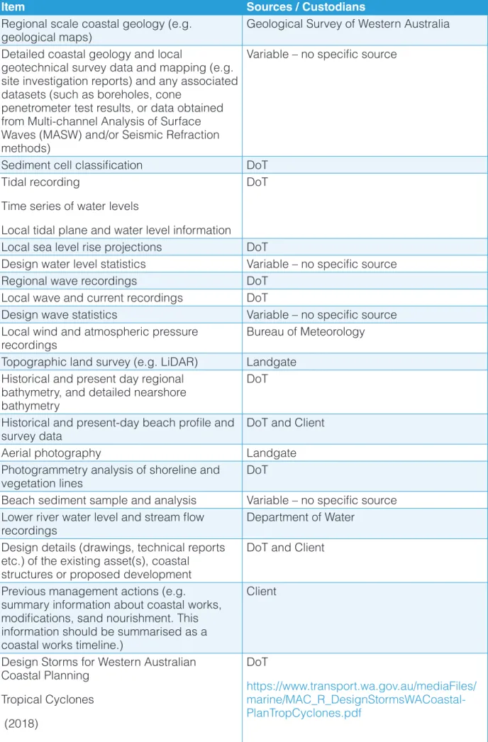
A significant amount of data and information is already available in most locations to support a local hazard assessment. This may not be a comprehensive list and it is expected that the consultant will thoroughly search the available records and information. Relevant datasets and information are briefly summarized to describe content, relevance to the current study, and any missing information or critical knowledge gaps.
When critical knowledge gaps are identified that could affect the success of the project, the consultant will describe the additional work required to fill these gaps. A field inspection/site visit is included to ensure the consultant visits the study area and to provide a snapshot of its characteristics, current condition and behaviour. A field inspection/site visit will be conducted to complement the desktop review, improve site familiarity and assist in the characterization of the local coastal processes.
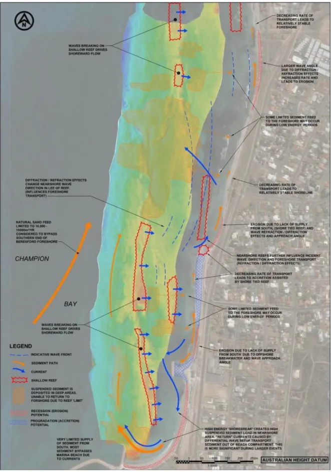
The information obtained is expected to help identify stretches of coastline that exhibit similar behavior and provide a snapshot of the current state of the coastal system. If the study area has separate parts of the coast that behave differently from each other, it may be necessary to divide them into coastal sectors for the purposes of this advice. The client will be invited to attend the inspection and may be able to provide further details on key coastal issues, observations and site history etc.
Basic GPS mapping of bedrock should be undertaken to compare with computer review, and/or to inform subsequent data collection. However, many areas lack accurate information on the location and characteristics of rock (both exposed cliffs, rock points and as substrate under sand dunes). For geotechnical data to be incorporated into and influence a coastal hazard assessment, it must be of sufficient detail to determine the characteristics of the rock feature(s) - particularly its continuity and elevation.].
For geotechnical data to be incorporated into and influence a coastal hazard assessment, it must be detailed enough to determine the characteristics of the rock feature - in particular its continuity and height, in accordance with SPP2.6. After reviewing available data and information, if critical data does not exist, it may be necessary to collect data as part of this scope of work. If critical data gaps are identified, a cost proposal (interim art to accompany the Project Execution Plan) should be submitted to the Client to fill the gap.
Develop conceptual model of key coastal processes
The conceptual model identifies the main parameters/processes that can cause coastal erosion and flooding for the study area (if applicable per sector). The relative importance and sensitivity of these processes should be determined and presented so that key processes can be focused when quantifying exposure to hazards for the study area in Task 3 below. Customer approval of the project execution plan is required prior to the commencement of task 3.
Quantify coastal hazard exposure and mapping
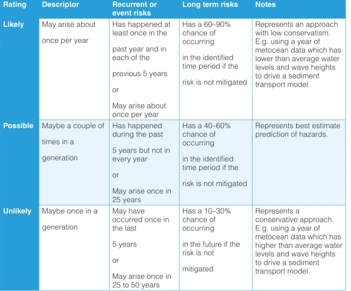
It happened at least once in the past year and in each of the past 5 years or This is a key feature of this rating scale to improve the confidence of the results.]. Simulated transshore and alongshore sediment transport and shoreline development during storms and in typical summer and winter weather patterns, and; identification of sediment sources, sinks, pathways and vulnerable areas to focus on in subsequent phases of the study.
The Consultant will provide details of the proposed modeling package(s) required to achieve the desired outcomes within their response to this Scope. A description of the hazard characteristics expected to be produced from the method is provided to guide the preparation of hazard maps. Model results will be presented as maps that clearly show the magnitude and extent of the erosion and flooding hazard for each time frame and probability scenario.
It is important that the consultant provides updated reporting and summarizes what is understood about the study area after the completion of the detailed study and modelling. After using modeling and associated comparisons, interpretation and mapping of results, it is expected that the consultant will have gained an advanced understanding of the study area. The conceptual model developed in task 2 should be updated as necessary to reflect any improvements in the understanding of the behavior in the study area.
In particular, any new information regarding sediment budget quantities will be presented. The purpose of the project execution plan will be to confirm a shared understanding of the scope. Upon completion of Task 2, the Consultant will revise and resubmit the project execution plan covering the remaining phase of the project.
The plan will further explain the consultant's methodology after identifying the management processes for the study area and will provide updated details on timeframes, milestones, tasks and deliverables associated with all components of the project. Description of report style and content required, along with more detail around the expectations of the presentation/discussion of the technical content. A copy of all data produced during the project will be provided to the client in standard formats.
The date of the field inspection is determined and a project implementation plan is provided. Have a Gantt chart to indicate critical delivery dates for each phase of the project.
Recommended datasets and information
Beach sediment sample and analysis Variable – no specific source Lower river water level and stream flow.
Data
Information and studies
Collection of geotechnical data/information
Where there is reason to assume that significant buried rock is present, but the extent is unclear, it is recommended that detailed data collection be undertaken. Multichannel Analysis of Surface Waves (MASW) – measurement of variations in the seismic S-wave velocity of the subsurface, a direct indication of the soil strength and compaction of the material. Seismic fracturing can be applied in areas where MASW is not suitable - such as in highly vegetated dunes.