This plan has been prepared for general information purposes only and uses potentially uncontrolled data from external sources. CLE does not guarantee the accuracy of this plan and it should not be used for any detailed site design.
Introduction and Purpose
3403Rep7A 3 The preparation of this LSP has involved extensive consultation with the City and relevant service. In addition, the proponent has been in regular consultation with the Department of Lands, as well as pipeline operators APA and DBP to ensure that the LSP and subsequent development works can meet the statutory requirements relating to the protection of the pipeline and risk minimization.
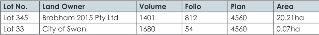
Land Description
Trees become more prominent around the St Leonards Creek north of the LSP area. Lot 345 is encumbered by an easement in favor of the Department of Lands for the purpose of housing the Parmelia gas pipeline.
Planning Framework
The majority of the area is grassland with generally sparse trees that include a mix of native and introduced species. According to section 5A.1.5.2 of the scheme, a local structure plan can be drawn up for all or parts of a structure planning area.
LSP2
LSP3
Biodiversity and Natural Area Assets .1 Flora and Vegetation
The vast majority of the habitat consists of weedy grasses that have no ecological value. Previously, through the DSP process, it was identified that a Potentially Threatened Ecological Community (TEC) occurred in the northwest corner of the LSP area associated with Eucalyptus Banksia forest. In 2006, Cardno, on behalf of Terranovisa, performed an analysis of the portion of this assemblage occurring within plot 350 (to the north) and determined, based on the vegetation classification, that this assemblage was not a TEC.
This area has since been cleared and developed for residential purposes with approval from the WAPC and environmental agencies. Considering that the part of the possible TEC that lies within the LSP area consists of the same vegetation community, it is reasonable to conclude that no TEC is present in the LSP area. There are opportunities to recognize riparian vegetation in the St Leonards Creek open space to the north of the site, and through planting and landscaping, increase the potential for suitable faunal habitat within the LSP area.
The topography of the site falls from west to east, grading gently from approximately 34 meters Australian Height Datum (mAHD) to 22 m AHD. These land types are typical of the Swan urban growth corridor and the Brabham area and are not a constraint on development.
Ground and Surface Water .1 Groundwater
Bushfire Hazard
Heritage
Other Land Use Opportunities and Constraints
Immediately west of the LSP area is the Ariella Private Estate (Local Structure Plan 1B), a residential estate of approximately 480 dwellings, as well as a public primary school and 3ha of nearby playing fields / active open space. The LSP area falls within the catchment area for both the primary school and associated neighborhood park, providing excellent access to community facilities in the short - medium term. To the east of the LSP area is a substantial future urban land holding of 106ha under the sole ownership of the Department of Housing.
The primary school and local center are located less than 400 m to the east of the LSP area and provide a context for increased density in the central and eastern part of the LSP area. Pritchard Francis Consulting Engineers have undertaken a review of the existing and planned infrastructure for the LSP area. Pritchard Francis concludes that the LSP area has excellent access to all essential service infrastructure and that existing services from neighboring developments to the west and north can be extended to serve the LSP area without requiring substantial improvements.
The pipeline corridor, containing the Parmelia pipeline and the Dampier to Bunbury pipeline, runs in a north-south direction along the western boundary of the LSP area. Pursuant to the DSP and recent structural plan approvals to the north and west of the LSP area, there are opportunities to eliminate easements within a utility reserve or similar, with adjacent residential land use.
Land Use
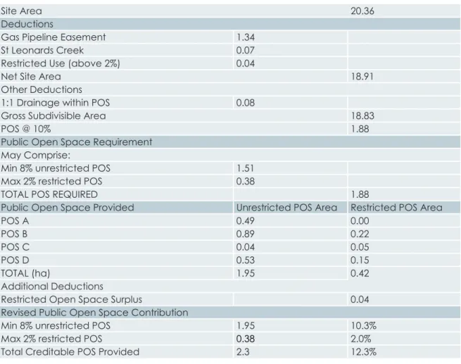
The DSP states that the calculation of public open space credits will be calculated in accordance with the Liveable Neighborhood Principles, which recognize the detailed water modeling carried out at the LSP level as part of the local water management strategy. The LSP concept plan provides for the provision of approximately 2.45ha of gross public open space, including St Leonards Creek open space to the north and multi-use open space to the south. Livable neighborhoods allow up to 2% of the required 10% open space to consist of limited use open space.
Consistent with the DSP, the LSP includes a multi-use open space adjacent to the southern boundary of the LSP area. This open space is approximately 0.71 ha and provides an open space with high amenities directly adjacent to Woollcott Avenue. It is envisaged that this open space will become the main meeting place/centre of community for the future population of the LSP area, and possibly for the residents of Avonlee to the north.
When the adjacent area to the west is developed, POS 4 will form an eastern extension of the larger active open space adjacent to the elementary school to the west. The planned area of district open space to the south of the LSP area which will form the primary recreational area for the suburb of Brabham.
Bushfire Protection
The east-west neighborhood link road that crosses the middle of the structure plan area and connects the two primary schools to the east and west of the LSP area. The LSP identifies a clustered housing site in the north-east corner, adjacent to the St Leonards Creek POS. Plots in the south-west corner of the LSP area - A larger plot of woodland vegetation is to be retained within the Resource Enhancement Wetland to the west of the LSP area adjacent to Woollcott Avenue.
If development within the LSP area continues ahead of that on land to the east, the vegetation on that land will need to be considered from a fire management perspective. This report builds on key elements of the previous traffic assessment prepared as part of the DSP and provides updated traffic patterns specific to the LSP area. Below is a summary of indicative cross-sections and reserve widths for key roads within the LSP area.
An eastern extension of this access street A is envisaged in the LSP to connect to the planned elementary school east of the LSP area as part of future planning for the eastern landholdings. All other streets within the LSP area are classified as Access Street C due to the low expected traffic volume and the local access function provided.
Water Management
Frequent events (≤1yr ARI event) infiltrated within the majority of lots through the use of water wells, with runoff from roads infiltrated by a bio-retention system within either public open spaces or roadsides;. Smaller sites (<300m²) will have site connections to the street drainage network, eliminating the need for cisterns within the site, and ensuring that the water will be treated and infiltrated into bio-retention areas within open spaces and/or road swales;. The minor system consists of underground pipes, curbs and gutters designed to transport runoff up to the 5 year ARI event and ensure the serviceability of the road network.
The main system consists of roads, swales, open spaces, St Leonards Creek and the Woollcott Avenue Drain, and provides protection to the community against extreme flooding (up to the 100 year ARI event) that exceeds the capacity of the minor system. As demonstrated in Figure 17, the LSP responds to these key principles by locating public open space at the low point in each drainage catchment, and ensuring that each area of open space serving a drainage function is appropriately sized and dimensioned to improve efficiency and maximize functionality of the open space. This removes the requirement for underground drainage and ensures a low maintenance, low risk solution for managing groundwater.
As noted above, the underlying aquifers are currently fully allocated, creating opportunities for a range of water-based landscape treatments across all open space areas. These aquatic open spaces complement the 3.12 ha of active open space located just west of the LSP area, which will provide active recreation that requires irrigated grass areas.
Education Facilities
Activity Centres and Employment
The LSP reduces default congestion by proposing to separate the residential development from the pipeline corridor with an 18m wide access street. The LSP site has access to the existing reticulated wastewater system via the planned Type 90 wastewater pumping station on Youle-Dean Road. Access to the pumping station will be provided via an external sewer pipe extension from the south side, with the route of the extension to be confirmed in consultation with the water company as planning progresses.
The extension of the sewer main to the LSP area will also allow for the decommissioning of the temporary Type 10 pump currently in use on Lot 9203 to the north. The Water Corporation has confirmed that the LSP area can be serviced by extending the existing 250mm water mains located on the northern boundary within the Avonlee estate. As such, the development of the LSP area will not require the construction of new substations, as all demand can be met with the existing substations.
NBN or Telstra well and pipeline infrastructure will be installed as part of the subdivision works, with the preferred provider determined as planning progresses. Gas reticulation will be installed as part of the common trench, which follows the water main from north to south of the LSP area.
Developer Contribution Arrangements