It is a series of occasional papers in the general subject area of resource management and is jointly published by the Resource Science and Land Management Branches of the Department of Agriculture, Western Australia. Intended contributors should contact the convener of the RESOURCE MANAGEMENT TECHNICAL REPORT Series Publications Committee. Consistency in these patterns indicated a need to revise the location of some of the botanical district boundaries.
The integrated database was subjected to a preliminary numerical classification of the floristic composition of plant stands. The analysis of taxon lists from 2522 locations showed that the floristic composition of the plant stands in this area is very diverse. A preliminary analysis of the distribution patterns of the 500 defined floristic groups highlighted some consistent patterns among the major vegetation types.
The database should be integrated with comparable data from other parts of Western Australia and that of the Western Australian Herbarium in a way that maximizes the taxonomic validity of the recognized taxa. A sampling program should be started in the area north of Mingenew, possibly with one of the very little known Yuna areas.
INTRODUCTION
Geology
According to the scheme of Bagnouls and Gaussen (1957) the Dunes which are equivalent to the Tamala Limestone. Quindalup Dunes (Safety Bay Sands) is a narrow band along climate of the study area can be defined as Warm Mediterranean-. The Darling Fault is only a minor influence on the landscape. Beard (1979a) equated this with the 450 mm rainfall isohyet.
The Gingin significant changes in soil types testify to its presence in the Sharp cause a distortion of this gradient, apparently a majority of the area studied (see Figure 2). Evapotranspiration increases in a general west to Figure 2 is a map of the soils derived from Northcote et. The soils of the focus of the study area are mainly sand. Vegetation dominated by quartz.
Spearwood Dunes is weathered limestone with a mantle of brown and yellow quartz sand that is apparently left over from the weathering process. The soils east of the Darling Fault are generally heavier, often red and brown loams and gravels.
Drainage
Griffin & Associates The coastal plain is referred to in part as the Swan Coastal Plain. The Bassendean Dunes and Eneabba Plain have varying depths of gray and yellow sand with isolated alluvium.
IRWIN
AVON
Land use
FLORA
SITE DATA
Field Observations
Analysis and Summary o f Data from Sites
RESULTS
Alien Species
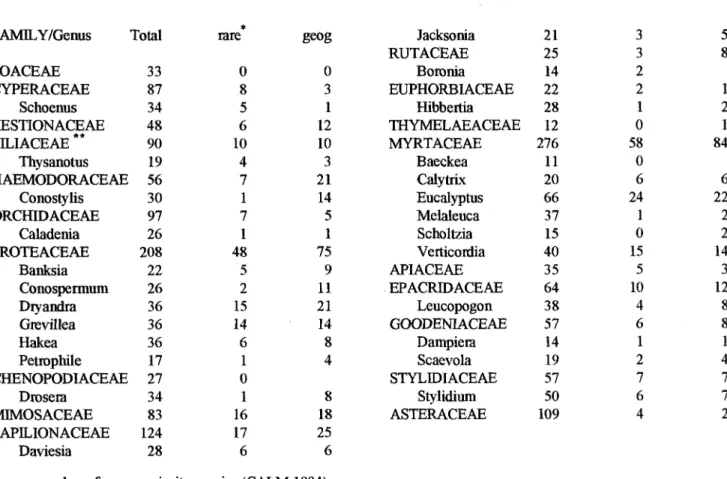
Rare and Geographically Restricted Taxa
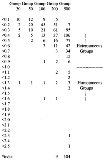
One purpose of this study was to demonstrate the degree of Group Group Group Group Group.
Classification of Stands
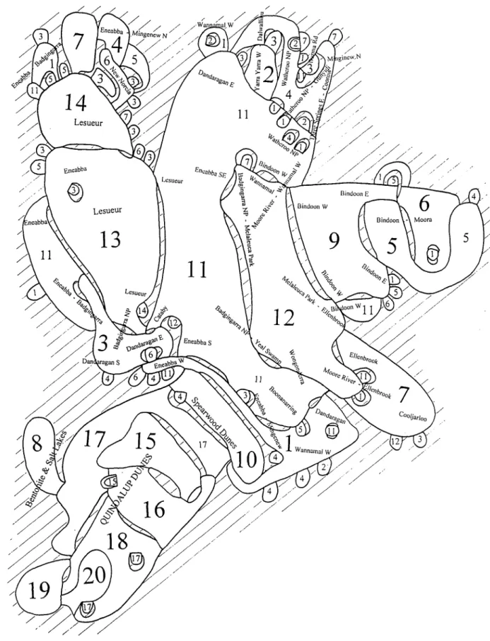
See Appendix 8 for more complete dendrogram fusion from 200 Group Level Adjacency between non-fusion groups does not imply high similarity. These show even at this very general level that while dunes and plains were represented in many of the 20 composition of the vegetation may be regionally influenced, groups, dunes or plains with calcareous soils were only in These regional patterns were more evident when the groups group 15 to 19. In this case landforms seemed to strongly influence the groups (appendix interpreted as regional patterns overriding both landform dix 9).
Most of the elements were the primary influence on all floristic groups of the landforms which were divided among a number of groups. All groups seem to do this. This suggests that land fomas are an important but not necessarily the result of combinations, with different emphasis, of these factors that most significantly influence the differences between the vegetation factors and perhaps others. The names on the figure indicate the locations where the sites (not shown) come from.
145 sites homotonity = 0.08 mostly plains and flats mostly shallow sand over gravel or gravelly sand or loamy gravel (all lateritic).
195 sites homotonicity = 0.03 mainly slopes including pediment and some uplands with brown clayey gravel (often lateritic, some shale or granitic) few species in common Neurachne alopecuroidea, Xanthorrhoea drummondii.
136 sites homotonicity = 0.00 depressions & valley flats gray or brown sand (or loamy sand) pre- . apparently on clay).
27 sites homogeneity = 0.00 bentonite playa lakes and depressions, some salty gray clay or sand over clay.
68 sites homotony = 0.25 high and low, gray and yellow sand over the Tamala Limestone at different depths.
142 sites homotony = 0.25 plains, flat depressions moderate to well drained, grey/yellow sand most common type. Banksia attenuata, Banksia menziesii, Petrophile linearis, Patersonia occidentalis, Bossiaea eriocarpa, Alexgeorgea nitens, Eremaea pauciflora ssp.
Veriore, Petrophile striata, Calothamnus torulosus, Goodenia caerulea, Haemodorum venosum, Schoenus brevifolia, Thyandra nivea, Baeckea grandiflora, Caustis dioica, Mesomelaena tetragona, Melaleuca trichophylla, Hakea. Amphipogon debdis, Dodonaea ericoides, Baeckea grandiflora, Melaleuca platycalyx, Hakea lissocarpha, Calothamnus sanguineus, Hakea longiflora, Opercularia vaginata, Jacksonia condensa Lesueur, Coornallo më të ngjashme me G20-13.
80 sites homotonicity = 0.20 dune & plain, well-drained, calcareous gray sand most common species Scaevola crassifitha, Olearia.
Associates A general summary of the most obvious combinations was: position is usually only obvious when large land fornis or soil types have a strong regional pattern. In this study, groups of coastal Holocene calcareous sands (groups 15-20, 15 to 20 were particularly clear in this regard as they were. It was the elucidation of this type of distribution of each of the 20 groups is presented on the border that justified including the data from outside the respective plots.
Presentation A certain amount of common features was observed in these samples. Figure 11 is an attempt to summarize them. This grouped the cities into 100 groups and only those types — We must not forget the preliminary nature of this analysis. A closer look at these data in this way is likely to have occurred in at least 20% of the areas in at least one of identify clearer patterns.
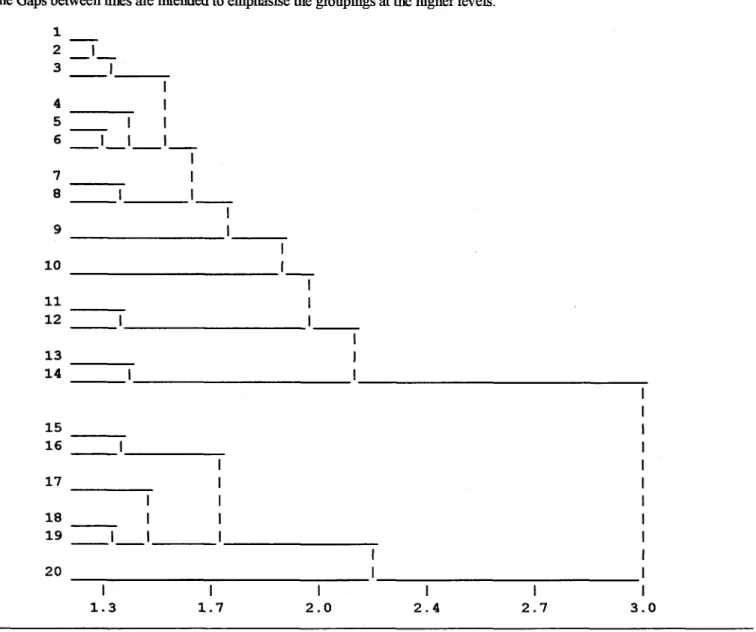
Finally, shared species among some of the 20 groups reflect the similarity between groups shown in the dendrogram (Figure 7) and the minimum spanning tree (Figure 8).
Regional Patterns
Database
DISCUSSION
Floristic Patterns
E A Griffin & Associates 63 Northern Sandplains (Perth - Geraldton) boundaries based on climate are unlikely to be as precise as correlated with the variation in the underlying Mesozoic sedi-one readily deduced from Beard's map.
A Lesueur Botanical District?
Conservation Significance
ACKNOWLEDGEMENTS
Griffin & Associates Gibson, NG, Keighery, BJ, Keighery, GJ 1980) West-Australië en Lyon, M (1994) Floristic Survey of the Southern soortenrijke kwongan (sclemphyllous shrubland) al-Swana Coastal Plain. Ongepubliceerd rapport voor bentonietrapport door WAIT-Aid voor Allied Eneabba Pty Ltd. 1992) Floristic Survey of Rest Vegetation in the Bindoon to Moora Area. Ongepubliceerd rapport aan Coastal Planning Branch, Department of Planning and Urban Development and the Heritage Council of WA 1982).
The short-term effects of brush harvesting on the Kwongan vegetation at Eneabba, Western Australia Dept of Fisheries and Wildlife Report 4 5 38pp. The Vegetation of the Darling - Irwin Botanical Districts and an Investigation into the Distribution of the Family Proteaceae in South Western Australia, unpublished PhD. Thesis, Botany Department, University of Western Australia, Perth. Wills, R.T., (1989) Management of the flora used by the European honey bee in kwongan of the Northern Sand Plains of Western Australia.
APPENDICES
Field sheet
List of species which, for various reasons, were deemed appropriate to combine for the analysis in PATN. The combination is reported in this study (& in the file NSP-MAST.dbf) under the last mentioned name.
Species List
MONOCOTYLEDONS
Name Changes for Previous Studies