People of the City
Observing but also being observed
Young Kyung (Kyle) Kim 1435060
Principal Supervisor: David Turner Associate Supervisor: Ainsley O’Connell
An Explanatory Document submitted in partial fulfilment of the requirements for the degree of Master of Architecture (Professional).
Unitec Institute of Technology, New Zealand 2022
Word Count: 11653
Abstract:
Public urban space has always been the essential element to consider in creating opportunities for socialising and allowing people to gather in cities. An architecture creating a place of public life through a design of a building and a public outdoor space will become evident through the development of this project. The project argues that education for the younger generation is needed. A place that can combine the functions of education and socialising is lacking in the centre of Henderson, as education will act as a crucial part of town growth in various ways. An educational space with a strong sense of historical identity and a connection with the outdoor space close to one of the town centre’s two streams was chosen for the project site. The building provides many different cultural functions to attract people with various interests to the building and its external spaces. Jan Gehl’s theory of public spaces from his study of “Life between Buildings”1 was identified as the source of ideas that, in the process of social life in an urban environment, people attract people into a city’s meeting arenas. The project’s intent is based on the sense of public life through architecture in the Henderson town centre.
A close analysis of the background of local history and businesses has been the cornerstone most useful for developing the proposed building's forms, internal organisation, and functions.
1 David Sim, Soft City Foreword by Jan Gehl. (Washington, DC.: Island Press, 2019), 3.
People are attracted to exhibitions and arts, and a place for these functions will be made visible within the building to ensure that these exhibition spaces advertise themselves to the people passing by.
Acknowledgement
I would like to thank my supervisor David Turner for your encouragement and support you have given me throughout the final project. I would also like to thank Ainsley O’Connell for your input and guidance.
To my friend Hasin, who I always could trust to receive motivation and positivity during challenging times, allowing me to push myself during the journey of my five years of studies.
Finally, to my family: Thank you Dad and Mum for your constant support from back home and thank you Jack for the support you have given me to focus on my final project.
Table of Contents
Abstract
3Acknowledgement
51.0 Introduction
Research Question 9 Title 11Introduction 11
Methodology 13
2.0 History of Henderson
Waitakere Ranges to Henderson 15Waitakere Kauri Mill and Timber Dam 17
Wineries and Vineyards 18
Brickworks 20
Great North Road 21
3.0 Henderson of Today
Henderson Library & Unitec Building 23Arts and Entertainments 24
Te Puna Market 26
Zeal & Waitakere Resource Centre 27
Westcity Waitakere & The Boundary Henderson 27
Henderson Train Station & Henderson Service Centre Building 28
4.0 Contextual Research
Site Surroundings 31Population Growth 32
Henderson Town Centre’s Activeness 33
Site Analysis 34
Walkway & Cycle-path 35
Car Parks 37
5.0 Urban Planning
Eke Panuku Development Auckland - Henderson, the Eco-centre of the
West 39
People-Centred City 40
Soft City (Dense-Low City) 41
Education a Part of Town Growth 43
The Renaissance in Florence (Education and Population) 44
Offline and Online - the Impact of Financial Status 45
A Place for Art 46
Streets and Buildings 46
Public Access and Circulation 48
Stream - Being the Edge of Attractions 49
Connection of Residential to the Town Centre 49
6.0 Precedent Review
Freyberg Place 51Santa Maria Novella - Brunelleschi, 1436 52
Mont de Marsan Médiathèque - archi5 - France 53
Auckland Art Gallery Toi o Tāmaki - FJMT + Archimedia Architects 55
Cheonggyecheon Stream - Seoul, South Korea (Clean Natural Stream) 56
7.0 Design Stage I
Concept Design 59Existing Building 59
Available Elements and Space 60
The Function of the Building 61
Space and Scale 61
Circulation within the Outdoor Space 63
Stream Consideration 63
Remembering the Past and Imagining the Future 63
8.0 Design Stage II
Developed Design (Revision of Previous Design) 65Circulation: Indoor Space 67
Material Decisions 68
Conclusion
71Final Design
73Bibliography
94List of Illustrations
96Research Question:
How can a sense of public life be enhanced
through architecture?
Title:
People of the City - Observing but also being observed
Introduction:
Selecting a site for this research project is a key decision for a study of the relationship between architecture and the design of spaces that can
enhance public life. Henderson City is one of the Auckland region’s four principal sub-centres. It has a long-established town centre formed around the original Great North Road connecting Auckland City to the north of New Zealand. There is no civic centre in Henderson where public outdoor space is available. A site was located at an early stage with the
characteristics of good links to the east side of the town, a north-facing open space that is under-used, and an edge that is defined by one of Henderson’s waterways (the Wai Horotiu stream). It connects to the main spine of the city – the shopping “main street” – via two footpath routes and the existing Trading Place Street at the southern end of the Great North Road, which provides vehicular access.
In the site's surrounding context, Waitakere Central Library, a satellite campus of the Unitec Institute of Technology, and Waitakere District Court are nearby. As these buildings will not be removed or change their function, they can be regarded as permanent features and will always contain staff, students and visitors. Therefore, the site is a place where people can meet, stay, and enjoy the outdoor space: it is a destination for many of Henderson’s public activities.
While the Project’s focus is on the intersection of architecture, public life and the richer social activity that can be generated by good design, other factors also contribute. On this site and in its context of a regional sub- centre that has been allowed to neglect its provision of public space, the natural environment plays an important part. The development of a design framework that responds to the site’s traditions in its local history and landscape conditions and recognises formal architectural elements is seen as the principal challenge.
Methodology:
A basic methodology for urban design and planning has four main
elements: general literature on the subject of urban space and its functions;
local history researched by local library collections; a physical survey of the site and its immediate context; and an analysis of the site’s
environment in terms of its potential for sustainable development. All other elements of urban planning fit into one of these categories. These include energy use and possibilities of solar energy sources, accessibility of public transport systems and servicing access, social priorities of the wider Henderson community, social customs and habits of that community, as well as architectural ideas about the material, scale, and the integration of natural environments as the urban landscape makes possible.
This research project will examine each of these elements to inform the design process. A more detailed survey of the site will be made after Henderson’s history is discussed and will include a short analysis of the physical context. The literature will be summarised in the methodology after the nature of the site and its sense of being a destination place have been established.
A closer examination was made of what is currently in the site
surroundings and what is missing, and as a result, several functions were listed to be used in the project building. Design of public outdoor space for
all the people from the town centre is needed to allow them to come out of their buildings and be part of the social life of Henderson in a civic centre.
The second use of the project is to create a co-working space for students from a young age to tertiary students of Unitec and adults who need a quiet place to focus on their work.
The use of brick as a dominant external wall material was an early decision: it was a local material of Henderson in the history and the neighbouring buildings of Waitakere Central Library and Unitec building were also constructed using brick. The intention of the architect of the building (Architectus) was the hope that the facilities would be the start of the development of Henderson town centre as a more attractive urban place with an identity built from its history. Therefore, continuing to express this identity with brick facings is an attempt to take those concepts further.
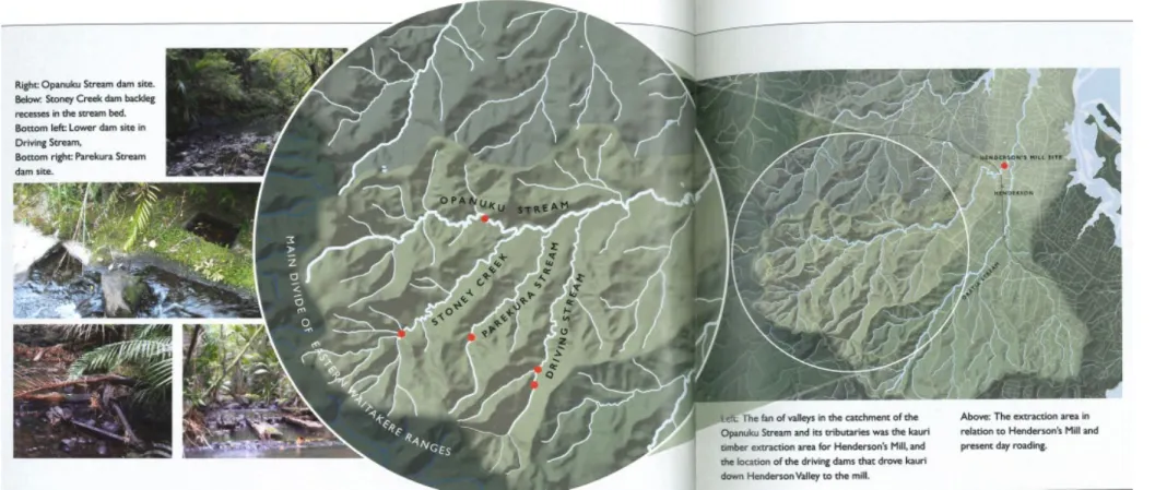
Figure 1. Waitakere Ranges dam sites.
2.0 History of Henderson
“People remember the past and imagine the future”2
What time is this Place? By Kevin Lynch History plays an important part in creating something new. As
environments change and cities transform, the past is often destroyed.
Kevin Lynch addresses in the text that his desirable image is to “celebrate and enlarge the present”3 whilst making connections with the past and future. The intention of researching the history of Henderson is to connect the past to the new development.
Waitakere Ranges to Henderson
The importance of the stream connecting the Waitakere Ranges to Henderson can be shown through the historical evidence of the kauri milling industry. As can be seen from many historical backgrounds, people settle in a location where food and water are closely available. The stream is one of the common locations for people to settle. In Henderson, the Opanuku Stream connects to Wai Horotiu (Oratia Stream), close to Te
2 Kevin Lynch, What Time is This Place? (Cambridge, Mass.: MIT Press, 1976), 3.
3 Lynch, What Time is This Place?, 1.
Kopua (Falls Park). Henderson Creek, the head of the tidal estuary, has been located as a landing place for the waka. Also, a small pa was built in the location until it was destroyed in the course of the development of Henderson.4
There is evidence from records in the nineteenth century showing how mainly pakeha social gatherings formed near streams: “stylish and elegant”
picnics in Oratia stream and Henderson Valley are illustrated in newspaper reports from the 1890s and from the old mill site in 1905.
Timber was used on streams to create dams to create swimming pools which attracted tea kiosks and eventually the construction of dance halls.
These recreational areas developed into Carey Park as we know it today.5 Henderson’s history is evidence of how streams were a necessity to provide food and fresh water but also provided places for people to gather to socialise around attractive natural environments.
4 Vivien Burgess, Gai Bishop, Grant Cole, Henderson Heart of the West, Edited by Paul Moon (Auckland, New Zealand: West Auckland Historical Society Inc, 2017), 33.
5 Burgess et al., Henderson Heart of the West, 112.
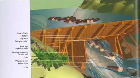
Waitakere Kauri Mill and Timber Dam
Local history seems not to be valued in a way that ensures memory; as Lynch notes, “desirable image is one that celebrates and enlarges the present while making connection with past and future”6 more people need to learn their local history to have their unique story told and their colour given expression. Henderson would not be complete without the story of the timber mill,7 starting from 1847, when the timber industry in
Henderson had started. With a small group sent to the forest to log kauri, the driving dam was an important feature of the process as it helped to float the timbers down to the headwaters of the creek from Waitakere Ranges to Henderson.8 Therefore, the site chosen for the project has a tragic history of the logging of the kauri forest but will be remembered through architecture to allow the new generations to learn about the history of the area. The history of mass kauri logging in Waitakere between 1849 to 1868 could be remembered within the project by prioritising the
environment and natural sustainability through architecture. This objective in urban development encourages ideas that lead to choosing a site which has easy access to the natural environment in the town centre to allow people to feel the nature inside a busy civic centre. Making use of local materials could also create an image of how the project has tried to use
6 Lynch, What Time is This Place?, 1.
7 Burgess et al., Henderson Heart of the West, 49.
8 Burgess et al., Henderson Heart of the West, 58.
sustainable resources and has tried to reduce unnecessary use of imported materials.
Figure 2. Diagram of timber dam.
Wineries and Vineyards
From the 1890s, commercial fruit growing industries emerged in the area, as 400-hectare blocks were purchased for fruit farming known as the Pomaria Estate. The list of fruits and vegetables was apples, strawberries, potatoes, cabbages, and carrots, but also grapes started to be grown in the area.9 The lands were previously all gum fields; a valuable resource sought after in the nineteenth century for the manufacture of furniture varnishes:
from all the gum digging, there were leftover holes as the industry of gum digging came to an end. Interesting fact from the Babich family, a local whanau like many others in West Auckland, originally from the Balkans in Europe, came to New Zealand not to make wine but to make a living through kauri gum digging. They did not decide on these lands for the quality, but the lands were originally quite cheap to purchase.10 After the demand for kauri gum declined in the first decade of the twentieth century;
the early settlers had to search for another way to make their income through another business, which was the start of orchards and vineyards.11 The local wine industry began with the Corban’s family and a few other winemakers nearby. Some are still prominent in the twenty-first century, including the Soliaks, Delegats, and Nobilo families.
9 Burgess et al., Henderson Heart of the West, 116-118.
10 Sophie Tomes, Wines in the West (Auckland, New Zealand: West Auckland Historical Society Inc, 2013,
11 Burgess et al., Henderson Heart of the West, 136.
Figure 3. History of Wineries in Henderson.
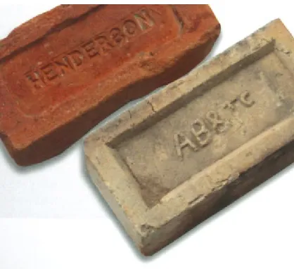
Brickworks
From 1884, brickworks were operating in Henderson, along the eastern side of the Te Atatu Peninsula, where it meets Whau River, where the Auckland Brick and Tile Company was operating.12 The use of brick was widely used in West Auckland as New Lynn also was very well known for bricklaying. Again, to memorialise the historical elements of Henderson, the surrounding building of Henderson Library and Waitakere Campus of Unitec Institute of Technology has mostly been built with brick. This small neighbourhood is now another branching development of the Henderson CBD13, and for new civic buildings, the use of similar or the same material will create a connection between buildings to produce a feeling where people feel as if they are inside the space, or they are entering it.14
12 Burgess et al., Henderson Heart of the West, 102.
13 “Henderson Library & Unitec Facilities,” Architectus, accessed April 13, 2022,
https://architectus.co.nz/work/waitakere-central-library-unitec-facilities/.
14 Gordon Cullen, Concise Townscape (London: Taylor & Francis Group, 1995), 7. ProQuest Ebook Central.
Figure 4. Henderson Brick & Tile and Henderson Brick & Tile.
Great North Road
As noted earlier the history of Great North Road has been the main route to the West and all destinations north of Auckland until the harbour crossing was completed in 1957.15 The Great North Road passes through the centre of Henderson which is very close to the site of the project where the road acts as an entry and exit through the town. As this road connects the Auckland CBD to Henderson and public transport passes along this road very often, it has the potential to attract people to visit the place easily by bus, cycle or private vehicles.
15 “Make Great North Road Great Again,” Bike Auckland, accessed April 14, 2022, https://www.bikeauckland.org.nz/make-great-north-road-great.
Figure 5. Architectus Education Project of Henderson Library and Unitec Building.
3.0 Henderson of Today
“Success in managing environmental change, and that the external physical environment plays a role in building and supporting that image of time”16
What Time is This Place, Kevin Lynch
Understanding the external context plays an important role before the design work on the project starts as it impacts on the decision of how the new building can be reciprocal to the surroundings. Close observation of surrounding buildings is needed to understand how their functions have been changed from the past and how a future plan is best made for them.
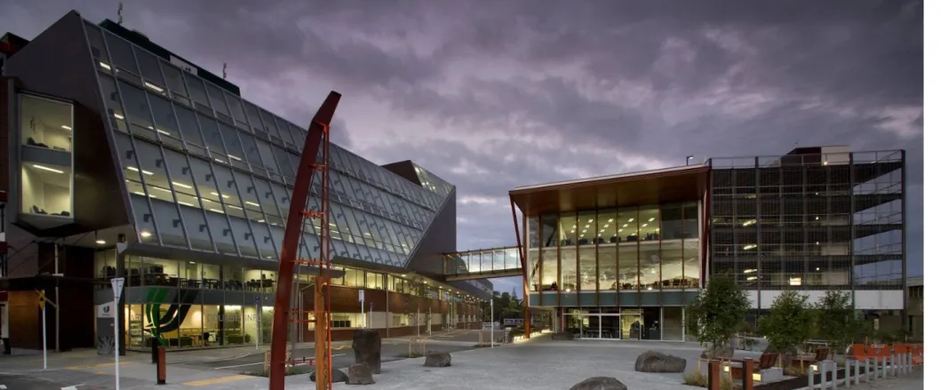
Henderson Library & Unitec Building
Important buildings which are closest to the project site are Henderson Library and the Unitec Building, which were designed by the well-known Auckland-based architects, Architectus. The function of these buildings is mainly educational, which also connects to the project's aim. As these buildings were part of a building programme which included the
16 Lynch, What Time is This Place?, 1.
Henderson Service Centre, a building group built for the Waitakere City Council on the other side of the Town Centre in 2004-2007, also designed by Architectus, they effectively started the redevelopment of Henderson.
Both buildings are about four or five stories or approximately 20 metres in height, both have extensive glazed elevations, and the other main external material of brick can be seen throughout the buildings and timber as their secondary material. This can be seen as a timber structure supporting the roof of the Henderson Library and the timber exterior cladding on top of the brick cladding on the Unitec campus.
The buildings also carefully use roof lights to allow natural light to enter and brighten the library without direct sunlight. The Henderson Service Centre focuses on energy efficiency by using integrated air-distribution floors to reduce heat gain through the building during the summer.17 These two buildings seem to be close to the heart of the town centre as the location is a short distance from retail shops surrounding the two buildings;
this means these buildings are very accessible from any direction and are close together, separated only by a narrow lane. The shorter the walking distance, the more people will be likely to visit the space or even use it to walk through to their destination.
17 “Henderson Service Centre & Transport Interchange,” Architectus, accessed April 14, 2022, https://architectus.co.nz/work/waitakere-civic- centre//.
Arts and Entertainments
An abundance of arts and entertainment are available around Henderson.
With a long history of the Corban family’s property in the central areas, the winery became a space for artists to gather and became an arts centre with various arts, such as paintings, sculptures and street arts. The location of the Arts Centre is framed by Opanuku Stream and is very close to Henderson Park. The main trunk rail line passes on the northern edge of the Arts Centre sites close to Henderson train station and Henderson Service Centre.
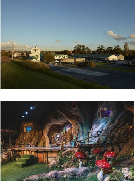
Further south of Corban Estate Art Centre and Henderson train station, Whoa Studio and The Grounds can be found. This complex is a popular destination for families consisting of a film studio, puppetry, miniatures, family eatery, and outdoor playgrounds: it is a place where any age group can enjoy or relax in the area, which is also a walkable distance from the train station.18
Extending the journey/tour of Henderson’s arts industry, another interesting destination of Auckland Film Studios can be found. The film studio is one of the largest studios in New Zealand and owns a large space
18 “Perfect For Families,” Whoa! Studio, accessed April 14, 2022, https://whoastudios.co.nz/.
in Henderson for filming and storage. The company will store a lot of movie properties - sets, backdrops, costumes and equipment - which they are planning to put on display to allow the public to visit.19
19 “Auckland Film Studios,” Auckland Film Studios, accessed April 14, 2022, http://www.aucklandfilmstudios.com/.
Figure 6. (Left) Corban Estate Arts Centre.
Figure 7. (Bottom) Stage set of Whoa! Studios.
Figure 8. (Top) Auckland Film Studios - Henderson.
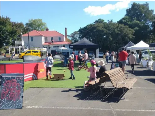
Te Puna Market
An open flea market occurring every Saturday opens in Falls carpark, consisting of different varieties of local fruits and vegetables, pastries, vintage clothes, second-hand bicycles, arts and live music. The market encourages sustainability through a community-based market and provides wholesale opportunities for direct trades between producers and
purchasers. The location of this market is around 100 metres from the selected site for the project.
Figure 9. Te Puna Market
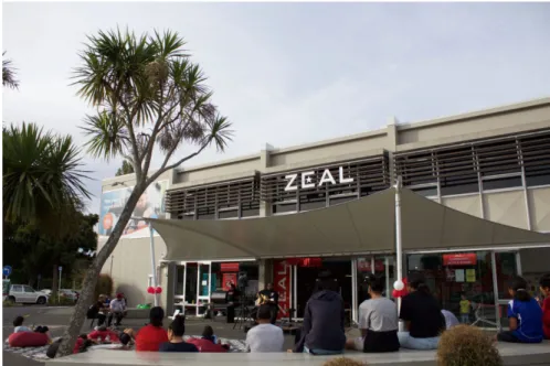
Zeal & Waitakere Resource Centre
A short walk from Te Puna market and across Waikumete Stream, a footpath connects to a local recreation centre consisting of an indoor swimming pool, basketball court, and a youth centre called Zeal. Zeal has a dancing space, recording studios, and a digital design lab.20 This space is for the Rangatahi (young people) who live in the West to give them the space and opportunity to learn new skills. Also, it focuses on entertainment and provides a place for young people to gather and enjoy their time together. The function of these buildings is very relevant to the project as this building focuses on educating the younger generations in various ways.
WestCity Waitakere & The Boundary Henderson
WestCity and The Boundary is the main shopping centre located in Henderson, with various shopping and food courts available inside the mall. It attracts many people inside it and is very close to the train station.
20 “Visit Zeal West Auckland,” Zeal, accessed April 16, 2022, https://zeal.nz/youth-spaces/westauckland/.
Figure 10. Zeal - Outdoor Space
Henderson Train Station & Henderson Service Centre Building
The primary public transport area with Henderson Service Centre, is connected to the train station. The building acts as a bridge to connect the western side of Henderson’s residential areas to the town centre. High- density residential housing is currently being built in this area in response to Henderson's increasing population, similar to other sub-regional centres at between 1 and 3 percent per annum.
Figure 11. Henderson Service Centre Building
Figure 12. Site Analysis of Henderson
4.0 Contextual Research
Site Surroundings
As the previous chapter addressed important buildings and sites near the project site, more research was done to understand the broader area. The list shows many art and music-related buildings in the town. However, this chapter will cover residential housing within a walkable distance of the town centre as the project aims to design a public building that attracts people into the newly developed space.
A housing development is currently ongoing on Edmonton Road, northeast of the project site, connecting Henderson to the North-western motorway.
The residential areas on the project's east side are mostly one or two-storey housing. However, they are currently being developed into high-density housing, reflecting that the town’s population is growing, and more
housing is needed. As more high-density housing is built, more people will recognise their lack of space within their compact properties: this may help to explain why public buildings or public outdoor areas are more needed to
“pull people out of private space into public areas”21 and allow them a space of socialisation.
21 Edward Glaeser, Triumph of the City (New York: Penguin Press, 2012), 124.
Population Growth
Population data of Henderson-Massey describes the population growth for each year and shows it has risen an average of between two and three percent annually.22 With the data showing a total of 118,422 residents in Henderson-Massey in 2018, it was a ten percent increase from 2013 which is similar to that of wider Auckland which is an eleven percent increase.
The increase of the population in Henderson-Massey indicates that it has been increasing at a steady rate.23
By looking at the age structure of the Henderson-Massey area, the data shows a significant increase in the 25-29 and 30-34 age group, but also a huge fall in the 15-19 age group. This data helps to understand what to develop in the town to maintain social and cultural facilities for the increase of the 25-29 and 30-34 age groups.
22 “Population Growth,” Infometrics, accessed April 21, 2022,
https://ecoprofile.infometrics.co.nz/Henderson-Massey/Population/Growth.
23 “Population Growth,” Auckland Council, accessed April 22, 2022, https://censusauckland.co.nz/files/Henderson-
Massey%20LB%202018%20Census%20info%20sheet.pdf.
Figure 13. Population Growth in Henderson-Massey Region (1997-2020)
Henderson Town Centre’s Activeness
An attempt to gather data on the town centre's activeness was made to understand the people’s purposes when visiting the town centre. However, it also showed which stores were not attracting people. Red highlighted buildings were closed or without any customers inside the building, yellow having very few customers, and green with more than five to ten
customers at a time. The data has guided which functions would be ideal to be included in the project and which should be avoided. Then from the town centre, the best location to develop the project was chosen by examining the number of users using each building and what could be demolished to construct a building that attracted higher levels of visitors.
The chosen building to redevelop contained a laundromat, a Salvation Army charity op-shop and automotive mechanics. The laundromat and the mechanics are the only active businesses in the block of obsolete buildings on the site. However, when these are all removed, it would not affect the local customers much as a new laundromat has been opened very close to the current location, and a car repair mechanic seems unnecessary in a town centre.
Figure 14. Activeness of Henderson Town Centre
Site Analysis
The best location for the development was considered through the data on building activity. However, the environmental context was also a critical factor in deciding the best site. A location with an abundant natural environment, close distance to educational facilities, and very close to the eastern entrance to the town centre justified the decision for the project's location. With the current site occupied with a car park and an existing building with only a few customers visiting the building, it was a good space to continue the expansion of the Henderson development, which began from the neighbouring buildings of Henderson Library and the Unitec Building.
As the town centre currently does not have an outdoor civic space for people to rest and relax, the project included creating an outdoor area within the design, expecting a broad range of age groups to enjoy the new cultural and social facilities inside the space.
Figure 15. Henderson Environmental Context
Project Site
Walkway & Cycle-path
Near the selected site for the project, a few walkways and cycleways are available for the public to use. Opanuku and Oratia Stream Path are the main two streams formed along the streamline and are mostly full of trees providing shelter from direct sunlight. The two streams join together to the north of the project site, but the Oratia Stream Path does not connect to the merging point. With the building site at the end of the Oratia Stream Path, the project's development could provide a connection that is currently absent and will encourage more people to use the walkways and cycleways.24 A new form of urbanism currently being used widely in Auckland is the “high-density low rise” model for housing, which offers reduced scale and allows residents to have a distinct identity for each home. Also known as “Dense-Low” housing which “celebrate(s) both individuality and community”25, this model recognises the need for individuality and sociability which are both desirable for every person.
24 “Opanuku Stream Path,” Auckland Council, accessed April 24, 2022, https://www.aucklandcouncil.govt.nz/parks-recreation/get-
outdoors/aklpaths/Pages/path-map.aspx?ItemId=95.
25 Sim, Soft City, 6.
Figure 16. Stream Path Near Henderson Town Centre
Car Parks
It seems there are enough car parking areas available in Henderson centre and this observation could change the use of the space to provide a better use. On the eastern side of the project site next to Edmonton Road, there is a long car parking space adjacent to the main east-side diversion road, which is usually empty. As this space is between the town centre and the residential areas, this space could be used for a better purpose, be more alive and welcoming, and link the residents to the town.
With the local history of brick in Henderson being very well-established, an idea of re-inventing the car parking space into a tennis court was made, as a clay tennis court uses crushed bricks for the final red top surface. This is a material many houses are made of; it can be made from recycled bricks from demolished buildings, and it could also help the environment as it will reduce the waste from demolition.26
26 “How to Make a Clay Tennis Court,” Dad Racket, accessed April 23, 2022. https://www.dadracket.com/how-to-make-a-clay-tennis-court/.
5.0 Urban Planning
“Having different activities coexisting is both useful and more sustainable.”
Soft City - David Sim27
Eke Panuku Development Auckland - Henderson, the Eco- centre of the West
Observations of the Eke Panuku plan for Henderson were reviewed to follow their development strategy for the town. A project name
“Unlocking Henderson”28 proposed by Eke Panuku shows a vision of Henderson to become an eco-centre, focusing on sustainability with a respect to the unique past, which includes the period from 1996 to 2010 when successive Waitakere City mayors adopted the concept that
identified the city as an eco-centred sub-centre of Auckland. The location benefits from a close distance to the Waitakere Ranges and the west coast beaches and is also relatively close to Auckland city centre and
27 Sim, Soft City, 214.
28 “Unlocking Henderson’s Potential,” Panuku Development Auckland, accessed April 28, 2022,
https://www.panuku.co.nz/downloads/assets/4605/1/unlock%20henderson
%20fact%20sheet.pdf.
Auckland’s other suburbs. The potential for increased growth is based on Henderson’s location with State Highway 16 and State Highway 20 linking into the city centre and Northshore, allowing easier access to this sub-centre from many directions around Auckland.
Vision concepts are for Henderson to become an “urban eco-centre” which can enhance the mauri (life essence of place and people) of the twin streams (Wai o Panuku and Wai Horotiu) flowing on and defining the edge of the town centre.29 With increased public transport, a “hybrid cycling”30 transportation system is encouraged through the development plan from Panuku.31 Hybrid cycling is also mentioned in David Sim’s Soft City, which proposes that a combination of cycling with public transport offers the possibility of local trips that are quick and efficient and which also connect to health and sustainability when reducing the use of private motor vehicles. With more movements and safe, economically viable transport options to encourage people to travel, the city will become more alive and attractive, creating chain effects for more people to use the city,
29 “Unlocking Henderson,” Panuku Development Auckland, accessed April 28, 2022,
https://www.panuku.co.nz/downloads/assets/4603/1/henderson%20high%
20level%20project%20plan%20(part%20one).pdf.
30 Sim, Soft City, 120.
31 “Unlocking Henderson,” Panuku Development Auckland, accessed April 28, 2022,
https://www.panuku.co.nz/downloads/assets/4604/1/henderson%20high%
20level%20project%20plan%20(part%20two).pdf.
all again relevant to the Eco-Centre theme. Eke Panuku also mentions the abundance of arts, recreational, educational facilities, and “Unlocking”, influencing further social events.32 This is anticipated to create future development opportunities.33 In principle, this policy will develop a city providing a wide range of activities for different age groups and allow the whole family to enjoy their time outside.
32 Panuku Development Auckland, “Unlocking Henderson.”.
33 Panuku Development Auckland, “Unlocking Henderson.”.
People-Centred City
“Bring people together and they create a collective surplus of enjoyment;
bring buildings together and collectively they can give visual pleasure which none can give separately.”
Concise Townscape, Gordon Cullen34
The “Unlocking” programme envisages a city full of social and
environmental harmony of connection between people and nature, people and place, but most importantly, a connection between people and
people.35 Where there are more people in a place, more unexpected events occur that fascinate and attract people from their repetitive daily life. To allow this to happen, an outdoor space acts as an important role of the city, where people interact with other people outside or in the streets. As cities become denser, property prices increase rapidly, forcing people into smaller offices and private houses. David Sim, writing with Jan Gehl emphasises that the “life between buildings” - in the city spaces that are public, well-designed, well located, and provide other facilities - are becoming more important in the city as depression and loneliness have become common experiences for city residents; Sim and Gehl argue that
34 Cullen, Concise Townscape, 7.
35 Sim, Soft City, 209.
these more accessible social interactions can help, and are therefore necessary for the health of the whole community.36
Several ways to encourage people into the public realm are suggested in Sim and Gehl’s study. A city needs to provide plenty of outdoor space for health benefits for individuals to exercise, get fresh air and have more social contacts.37 A local walkway dominated by the natural environment between the residential housing is desirable which also connects to the city centre, making it possible for people to walk or cycle to the town centre without using their private vehicles.
Applying these theories to the development of the Henderson project, it is noted that many of these align with Eke Panuku’s vision theme.
Henderson is a city with great potential to become a people-oriented city gifted with the twin streams flowing around the edge of the town, bringing people together and connecting to nature.
36 Sim, Soft City, 3.
37 Sim, Soft City, 100.
Soft City (Dense-Low City)
A trend of smart cities is expanding with new technologies boosting more opportunities to enhance a city with better environmental sustainability and energy efficiency. With modern cities creating visually cold and often spatially inflexible urban environments, new techniques were created to allow a softer image of the city. In Soft City, David Sim explains how a soft city and a smart city can be considered as a counterpoint or a complement to one another.38 While smart cities focus on new
technologies to create a highly complex city, a “soft city” describes a city that should look more into simple and smaller-scale urban developments.
A city with lower technology to reduce the running cost and a people- centred solution will soothe the urban atmosphere with lower carbon footprint. A place where people find it attractive and comfortable to be and will want to revisit the place. This is why Sim has argued that “softer may be smarter”39 and that a new method of urban development of “Dense- Low” has the main focus on human-centred designs.40 As an example of this approach, the streets in the Strøget in Copenhagen - a central shopping, entertainment and commercial district - have been pedestrianised. This has encouraged more social activity between visitors, residents and owners in which the public areas are more easily observed. Dense-Low allows us to
38 Sim, Soft City, 4.
39 Sim, Soft City, 4.
40 Sim, Soft City, 4.
celebrate both the important sense of individuality and, at the same time, enjoy a sense of community: whilst it seems the two are contradicting, a place for individuality and socialising is an important element for the city’s public spaces to provide.41
Only a few places can be described accurately as having a sense of privacy and an expression of individuality in an urban area. From what can be called a private area in the dense urban city, the first place will be their individual residential homes, where they are separated from the outdoors.
People can have their next individual time in their common areas, such as walkways and parks. This is because a person can decide whether to have their individual time while exercising in the walkway or to have their time to be in the company with other people.
This theory of Soft City has a parallel concept with the vision theme that Eke Panuku has on Henderson development, with an eco-city allowing more people to use more time outdoors and encouraging them to be an active part of the community.
41 Sim, Soft City, 5.
Figure 17. Skill Level in Henderson-Massey Region (2021)
Education a Part of Town Growth
Educational facilities can also act as important features that contribute to a town’s growth. Families with children will consider living in a house that is located close to a school for ease of transportation between their house and the school, to save time and reduce money spent on travel. A town with better quality educational facilities will also attract more people to that area as the perception exists that better facilities will result in an education that provides higher skill levels to the students.
To compare the skill level of Henderson-Massey to the rest of New Zealand, the table shows that the level of highly skilled and skilled workers is lower and that there are higher percentages in the semi-skilled and low-skilled area in Henderson-Massey region when compared to the rest of New Zealand.42 This disadvantages the area as the age composition in the population band up to 44 years old has higher numbers of people in the Henderson-Massey region than the rest of New Zealand. To prevent the flow of the younger age groups from migrating to another city, a constant improvement needs to be made to the educational facilities.
Henderson has a central educational concentration of good facilities, with Henderson Library and Unitec Institute of Technology having already existed for more than ten years. Development of the area could be made to
42 “Broad Skill Level,” Infometrics, accessed May 1, 2022, https://ecoprofile.infometrics.co.nz/Henderson-
Massey/Skills/BroadSkillLevel.
enhance the attraction of the younger age groups, from high school students to tertiary students. As New Zealand does not have many cities with tertiary schools, the relatively rare opportunity of the tertiary educational facilities in Henderson could be emphasised to attract more people into the area.
In the United States, it is usual practice in urban planning studies to calculate the percentage of the population that has completed their tertiary education to estimate the skill levels of each city. In the United States, between 1970 to 2000, counties with more than 10 percent of their population with tertiary education increased by 72 percent, while the population of places with less than 5 percent of the population with tertiary degrees increased only by 37 percent.43 This indicates that a correlation between education and population growth exists in urban communities, and it shows how population growth can differ by a large amount
depending on the adult population with tertiary education. Higher levels of education link to different income rates with data from the United States shown in Triumph of the City; over about one generation, for every extra year of schooling, the county's entire population increased 30 percent in per capita gross domestic product.44 Investment in educational facilities is for long-term benefits for both the people and the city, so the city needs to
43 Glaeser, Triumph of the City, 28.
44 Glaeser, Triumph of the City, 28.
build an easily accessible educational environment to encourage more younger generations to be well educated.
The Renaissance in Florence (Education and Population)
While it may be argued that the Renaissance period is defined by significant development in the studies of art, science or literature, an alternative compelling argument can be made that it is the introduction of the printed press that sets the Renaissance period apart from other historic periods.45 In the fourteenth century, the population of Florence was halved due to the Black Death plague, only recovering to its former size several centuries later. During this recovery period, only the highly educated elite classes had access to printed books as these were not only very rare but also expensive. With the assistance and money of the rich, more libraries began to be constructed in Florence, which in turn led to an increase in the number of books available. Initially, this desire for access to more books and places in which to store and read them was for the benefit of the rich;
however, this also made books more readily available to the general public
45 Jocelyn Hunt, The Renaissance (London: Taylor & Francis Group, 1999), 7. ProQuest Ebook Central.
which was of enormous benefit to the population at large, bringing great benefit to many, regardless of social class or wealth.46
As has been the case in many city histories, the experience of Florence in the fourteenth and fifteenth centuries illustrated the influence of education on the cultural development of the city’s population and their wealth: with the growth of interest in books and literature, the reputation of the city as a place to come to for access to other activities, particularly including commerce, expanded rapidly. Markets and trade grew alongside higher levels of literacy.
Offline and Online - the Impact of Financial Status
For Aucklanders in the twenty-first century, it has become hard to
socialise without spending money. Every time a person leaves their house, it will be necessary to have access to money, from travel costs to buying food and drinks or to enter a cinema or an exhibition hall. Most outdoor activities need money to be enjoyed. Also, it is difficult to find an outdoor area where people can bring their food to eat; people will most likely decide to find seating inside a shop, which again results in having money to spend.
46 Hunt, The Renaissance, 25.
As advanced technologies are created and more “higher-end entertainments”47 are featured, these became available only to the
wealthier and highly educated social groups. People who cannot afford to spend money will have no other options than to stay inside, as more time spent outside will eventually result in spending more money.
People that are not wealthy will be able to watch movies on their
televisions rather than going to the cinema; they will visit art exhibitions through their phones rather than physically attending museums or art exhibitions and listen to music through videos rather than going to music concerts. We can see the interrelation between people with fewer resources who will be spending more time in the “online” world while the wealthier people will be able to enjoy their public cultural activities by engaging in
“offline” time.
The focus of this project is to create a lively space for people to socialise, drawing people out of their compact houses and creating a place for lower- income families to also enjoy the outdoor space without worrying about spending much money. It is about creating a place to enjoy the natural environment and art exhibitions without the need for money to pay for entrance fees and local music festivals held for the community, a place people can visit without any concern of financial status.
47 Glaeser, Triumph of the City, 126.
A Place for Art
There is an abundance of arts in Henderson, with the potential to attract people into the town, offering a wide variety of artworks, cultural events, music events, and, for those looking for social venues, the numerous local wineries. The location for this project can be a place where artists can actively perform, display and express their works. As Glaeser suggests, more artists from the region will be attracted to affordable space and an art-based community will be formed. The city can flourish with arts and music, again creating more public events and exhibitions.
We can see this in other cities, such as Paris, which was also a city for artists to gather within. However, now only the wealthy can afford accommodation in the city.48
An art community forming in the city can be seen as a beginning of city growth and can then bring in its potential to be identified as a prominent satellite city for culture and art as an element of the city of Auckland.
48 Glaeser, Triumph of the City, 12.
Streets and Buildings
When a group of buildings are removed, a space between the remaining buildings naturally forms. Space inside the buildings is important when creating a townscape for their relationship through entrances and openings, internal visibility and functions. Paths on the public perimeter that connect entrances to the buildings are also “spaces” which can be formed and considered while designing a new complex.
Gordon Cullen describes the way in which a group of buildings creates external spaces between the buildings that have “a life of its own” - to feel as though a visitor is going “inside IT” or they are “entering IT”.49 To produce a space that conveys the sense of a person being “inside IT”, a group of buildings should be connected to each other and create a space of comfort, like an outdoor courtyard, a space where people feel protected, both physically and visually. A protected external enclosure creates a flexible “room” - which can be used for both temporary functions (“pop- up events”) or in different seasons of the year, and finally, a further
expansion to the building’s own internal space. Henderson is a city already with a programme of buildings waiting for expansion as there are some buildings already constructed but waiting for more development to occur through the city.
49 Cullen, Concise Townscape, 7.
David Sim also comments on the importance of grouping buildings, as he describes the way in which a group of buildings forms enclosures and controllable outdoor spaces that are also made with no additional cost.50 An urban environment needs to provide more protected space and sometimes a space that can provide a sense of privacy/quiet as these spaces allow more activities inside it.
These spaces develop into streets or squares, however to enhance the place with public life, it is necessary to create these public realms with
predictable conditions and make them comfortable to use.51
These physically and visually protected spaces in the public realm can be created by the group of buildings proposed in the design and will
eventually attract people and allow them to spend more time enjoying their public life.
50 Sim, Soft City, 18.
51 Sim, Soft City, 103.
Figure 18. Map Showing Street Access to the Site (By Author)
Figure 19. Contextual Map Showing Streets Connecting to North Shore and Auckland Isthmus (By Author)
Public Access and Circulation
Henderson town centre with Great North Road as the main road intersecting horizontally cuts the city in half. The city's southern half is mainly a shopping centre and small businesses on the main road. The upper half consists of again small businesses on the main road, but importantly, the Henderson Library, the Law Courts and the Unitec building take up most of the floor area. This area will be focused on developing, as in the previous chapter, the “group of buildings” that is already formed and is waiting for expansion. This space can be entered through Ratanui Street or Trading Place, which branch off from Great North Road, from which both pedestrian and motor vehicles can enter the space.
Public transport in Henderson links to the Auckland CBD through trains and buses. Henderson train station, which also has bus stops, is located west of the town centre. The train station acts as a bridge to connect the residential areas from the Henderson Valley Road and other western suburbs to the town centre, with a future higher density development in Auckland Council property which is currently a car parking area. Great North Road connects to Auckland CBD with both public transport and private vehicles, which is the entrance for the people from the direction of Auckland CBD.
Edmonton Road, northeast of the site, which links to Te Atatu Road, is access to the motorway that connects to the North-western motorway, which will be the main point of access for people from North Shore and Auckland isthmus to enter Henderson town centre. This is a locational benefit as Henderson has roads branching off to North Shore, New Lynn, and Auckland CBD, allowing easier connections between the areas.
Stream - Being the Edge of Attractions
The attractions of Henderson centre have an established natural environment, with parks and streams locating the edge of the city. Sim advocates a city plan that encourages people to walk.52 To highlight these existing features in Henderson, many walkways and cycle paths have been made along the streamlines, the main use of which is to allow more people to enjoy outdoor spaces and exercise, but these walkways also act as a path for people to arrive at Henderson centre through walking or cycling.
People need to cross over the streams to enter or leave the town centre, from perimeter car parks, allowing the interaction with the natural
environment. This allows the “in-between places” to be more enjoyable for people and feel the decision to walk is worthwhile. A walkway that has a
52 Sim, Soft City, 105.
“real value of everyday life” which can boost their lifestyle, through cycling time or a walk to the park.53
Connection of Residential to the Town Centre
Henderson town centre has two residential areas in the west and east of the city, which are within walkable distance. The west already connects to the town by Auckland Council’s bridge over the railway. The building creates connections between residential areas by shortening the city's walking distance and encouraging more people to decide on walking than using motor vehicles. The Auckland Council building has few functions to attract people, but currently, the east edge does not have a very attractive pathway to encourage people to walk into the city. The “in-between time and in-between places” are not yet “enjoyable and fulfilling”54 enough for people to enjoy their time walking in the city, so they will decide on using other transportation methods. Jan Gehl argues that the city must invite more people to use “green mobility”55, such as walking or cycling, to create a healthier and safer city for the whole community.
53 Sim, Soft City, 91.
54 Sim, Soft City, 91.
55 Jan Gehl, Cities for People (Washington DC: Island Press, 2010), 6.
ProQuest Ebook Central.
6.0 Precedent Review
Figure 20. Event in Freyberg Place
Freyberg Place
The small public square in Auckland CBD is favoured as a place to have lunchtime in an outdoor area. Freyberg place is a “breathing spot”56 from busy streets and can accommodate flexible functions such as live
performances, markets and different activities. With the benefit of north orientated space, the place allows sufficient natural daylight and is sheltered by the Ellen Melville Pioneer Women's Memorial Hall. With a slope across the site, the space became a more practical pedestrian space, with plenty of steps, allowing more people to sit and rest. To restrict the strong sunlight, pōhutukawa and nīkau palm trees were added to create a sheltered area protecting the steps. To reference the natural stream that had flowed near the site, a water feature was installed flowing through the steps, which also cools down Freyberg Place during the summer. The square and the adjacent building of Ellen Melville Centre have a wide- open screen allowing interaction from inside the building to the square, visually and physically. Freyberg Place shows how people inside the building can interact with people in the square and can create a connection in between the two indoor and outdoor spaces.
56 “One Hundred and Eighty-nine Steps. Freyberg Place,” Isthmus, accessed May 5, 2022,
https://isthmus.co.nz/project/freyberg-place/.
Figure 21. Public Outdoor Space of Santa Maria Novella
Santa Maria Novella - Brunelleschi, 1436
The fourteenth century cultural and commercial development of
Renaissance Florence in Italy was referred to earlier in this study as a city that benefited from its reputation as a centre of learning and education. In the nineteenth century Florence, alongside Rome, became one of the most visited cities in Europe, and now it functions as a memorable tourist destination. Its urban form and its grand and historic buildings attract architects and tourists from all over the world. Many of them see the Duomo cathedral of Santa Maria del Fiore, a short walk from the Firenze Santa Maria Novella train station. In front of the Duomo, an open square allows space for tourists to rest, a place enclosed by groups of buildings forming the square, giving comfort and security inside the space. People can enjoy the atmosphere while having a wonderful gothic facade of the Cathedral to admire. Young people dance in front of the church, some people use it as a thoroughfare, and some relax while enjoying the weather.
We can absorb some of these features from this plaza as this space creates a safe and open place for socialising and allows a safe and comfortable outdoor space where people gather or a thoroughfare that people will visit even if the walk is out of their route.
Figure 22. (Top) Mont-de-Marsan Mediatheque Lighting at Night Figure 23. (Bottom) Mont-de-Marsan Mediatheque Reflective Screen
Mont de Marsan Médiathèque - archi5 - France
A media library in Mont-de-Marsan, France, it has been designed with a fully transparent facade with a green roof. The building is built in the centre of a historic plaza. The facade's reflective screen reflects the surrounding environment and the people while allowing the people walking past to look inside the building. The plaza is also lit by the building throughout the night, acting as a lantern to the surroundings, providing a safe and welcoming environment even at night.57 The library has different functions of study areas allowing a wide range of age groups to use the building, having reading rooms, an open ground floor for study areas, and a private workspace.58
57 “Mont de Marsan Mediatheque / archi5,” Archdaily, accessed May 5, 2022, https://www.archdaily.com/478589/mont-de-marsan-mediatheque- archi5.
58 “Archi5 Shampes Reflective Mont de Marsan Médiathèque,”
Designboom, accessed May 5, 2022,
https://www.designboom.com/architecture/archi5-mont-de-marsan- mediatheque-marsan-media-library-05-02-2014/.
Figure 24. Auckland Art Gallery Entrance Showing Timber Canopies
Auckland Art Gallery Toi o Tāmaki - FJMT + Archimedia Architects
The Auckland Art Gallery invites people inside with an entrance with timber canopies with ceilings assembled with Kauri timber, sourced only from fallen forest stocks, to represent the finest timber found in the region while also avoiding the use of new kauri. These timbers were assembled to create canopies using the form of a geometric pattern based on traditional boat-building technology.59
This building was chosen as a precedent for this study because it uses a local recycled material as artwork in a building element. The choice of timber material exposes a warm welcoming at the gallery entrance.
59 “Auckland Art Gallery Toi o Tāmaki,” FJMT Studio, accessed May 5, 2022, https://fjmtstudio.com/projects/auckland-art/.
Cheonggyecheon Stream - Seoul, South Korea (Clean Natural Stream)
Cheonggyecheon stream runs through the centre of Seoul, flowing from west to east. The stream with six hundred years of history creates a main foundation of Seoul, bisecting the city into the north and south
meridians.60 Due to pollution, it was decided to cover the stream with roads and highways, starting from 1958 until 2003, when Seoul's mayor decided to remove them. The attempt to bring the natural environment back into the centre of the city successfully attracted 60,000 visitors a day after Cheonggyecheon was fully re-opened in 2005.61 People visit the stream for various reasons, from enjoying the walk or running along the stream, the length of almost 6km. People also enjoy the clean stream water, from kids enjoying the water to adults dipping their feet to cool them down.
There is also an annual lantern festival made up of Korean paper “Hanji”
during November, with a following Christmas light festival during
December. These festivals also attract a lot of families and friends into the area where they can enjoy the lights at night.
The restoration project allowed the Cheonggyecheon to restore its
60 “Downtown Revitalization: Cheonggyecheon Restoration Project,”
Kdevelopedia, accessed March 25, 2022,
https://www.kdevelopedia.org/Development-Topics/themes/--13.
61 “Seoul’s Cheonggyecheon Stream: History to Know, and Where to Go,”
Pinpoint Korea, accessed March 25, 2022,
https://www.moonbeartravel.com/cheonggyecheon-history-travel-guide/.
historical values (tradition), the culture (modernity), and nature (future) into the city.
Figure 25. (Left) People Sitting Along Cheonggyecheon Stream Figure 26. (Right) Light Festival in Cheonggyecheon Stream
Figure 27. Existing Building of Laundromat and Salvation Army Charity Op-shop (Photo by Author).
7.0 Design Stage I
Concept Design
Before any progress in design, a site had to be found and researched. A site that is waiting for development and has the potential to attract more people; is able to create a space for more socialising opportunities. As Cullen observes in Concise Townscape, there is an “art of relationship” to bring together all the elements that form an environment, such as buildings, trees, nature, water, and traffic, and weave them together in a way that drama is released.62 The main sub-centre of West Auckland, Henderson, has great potential in these “elements” but has no public open space where people can use outdoor areas.
62 Cullen, Concise Townscape, 7.
Existing Building
A new building will be constructed for the selected site. However, some of the existing buildings will have to be demolished. The selected site located in Trading Place currently has a single storey building with a laundromat, Salvation Army charity op-shop and automotive mechanics. As mentioned previously, removing these businesses will not affect the city or the customers using it, as there are very few visiting these shops. The
laundromat, the only shop many customers visit, can also be removed as a new laundromat has opened very close to the area at the intersection of Trading Place and Great North Road. A small outdoor area exists on the site, but it is designed as a car parking area, which can be removed as a car park building is available on the same street. Changing the car park area into a better public outdoor area will also be a key design point. It has a brilliant north-facing space that allows the best natural sunlight for both the outdoor area and the building. The outdoor space can have a walkway connecting the streams to the east side of Henderson, where medium density housing developments are currently being constructed, with more projects of housing in Alderman Carpark very close to the selected site in the future.63
63 “The Alderman Carpark” C40 Cities, accessed May 4, 2022,
https://www.c40reinventingcities.org/en/professionals/winning-projects/the- alderman-carpark-1305.html
Figure 28. North-facing Outdoor Space available on Project Site (Photo by Author)
Available Elements and Space
Before designing, the surrounding elements and buildings were observed.
With a north-facing outdoor space available on the route between the car park and the town centre, good natural light comes into the area and the building. This can be a good space for both summer and winter for people to socialise and stay to enjoy the sun. Henderson Library and the Unitec building enclose the west side of the site. With their common functions as educational facilities, the project will be an extension from these buildings, using the same materials to create a “group of buildings” with the material having a local history providing connections to the past.
On the east side, the edge of the town centre has a natural stream flowing from Waitakere Ranges, providing a natural environment as a barrier to the main distributor roads. This space could be developed for people to enjoy these outdoor areas while they are still in the city, for a time of socialising while being able to see the trees and the stream. Henderson has a significant benefit of having a very close natural environment to the native landscape. This attraction can create a city full of movement.
The Function of the Building
The new building will consist of various functions to attract wider age groups, with co-working space for any age group to use on the ground floor for easy access. There will be a cafeteria for socialising with an extra weather-dependent outdoor seating area. An exhibition space of local artworks will also be available on the ground level with seating areas to enjoy the artworks or the outdoor space. The building will include a digital learning space where people can use public computers or bring their own digital devices to study in the area. The building will also have a small open space, flexibly designed to hold different events such as small conferences or small exhibitions. This space can also allow local businesses to bring their products to open a small market.
Space and Scale
There is limited space inside a city, a city for new buildings while keeping as much space as possible outdoor areas. Henderson city centre could be enhanced into a lively place by creating more outdoor plazas creating places where people can enjoy their lunchtime or sit and relax taking time out from their busy daily life. A scale that relates to the surroundings could encourage bigger future developments in the city by private investors. The vertical height of new developments needs to consider the time and effort of accessibility for any age group to allow full use of the building. The height and the scale of the building are important factors to ensure they do not dominate or hide too much view of the natural environment.
A grid system was used to form the primary spacing of structural columns and sizes.
Figure 29. Circulation Around the Site (By Author)
Circulation within the Outdoor Space
There are two access points to the site, one from Trading Place and another by the bridge from Alderman car park. Trading Place having other educational facilities on the same road will allow students or other people to enjoy a visit to the site to view nature and get some fresh air. A bridge from the Alderman car park will be an access for the eastern residents of Henderson, entering the public plaza into Henderson city. A connection to the Henderson Library, Unitec Building, small businesses and public transport also needs to be considered as to how people will access the site and allow it to be a walkable distance.
Stream Consideration
The main essence of the project is the connection to the existing natural elements. The stream, connected to the history of Henderson, is currently hidden by car parks and buildings. Revealing the natural environment and merging this to the proposed development will interest more people to visit the site and enjoy their time in the newly created outdoor space. The natural curved forms of the stream will also be considered when designing
the project as it gives a sense of ease of movement to the circulation of people.
Remembering the Past and Imagining the Future
As cities develop, it becomes harder to preserve the past, from the local history or local businesses. The natural envi