Reproduction of all or part of this document is prohibited without the prior permission of Milestone (AUST) Pty Ltd.
Introduction
The Museum Discovery Centre
Overview
Government Cultural Policy Context
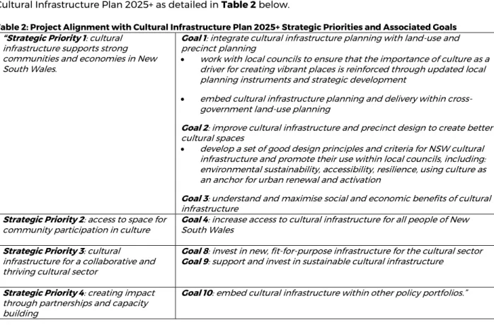
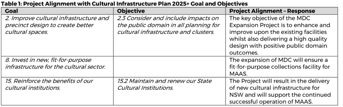
The Cultural Infrastructure Plan 2025+ sets out the NSW Government's strategic priorities and associated goals for the planning and delivery of cultural infrastructure across NSW. The proposal will support the achievement of the relevant strategic priorities and applicable objectives of the Cultural Infrastructure Plan 2025+, as described in Table 2 below.
Site Description
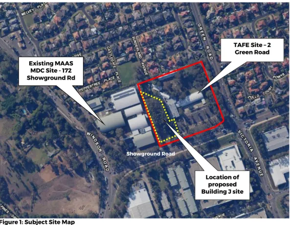
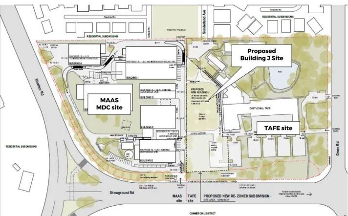
Building J location), from Building F on the MDC grounds. Photo 2: Northeast view of the site, from Building F on the MDC site. Building J, from TAFE's internal driveway Photo 6: View to the east looking at the site (trees in the background), Building F in the foreground.
Site Context
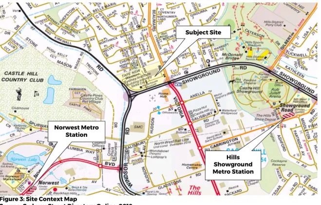
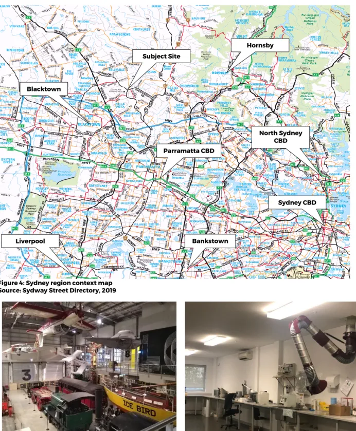
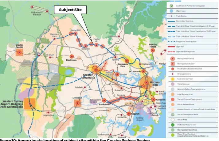
The site is located 1.1 km north-west of the Hills Showground Metro station and 1.45 km north-east of the Norwest Metro station (refer to Figure 3). The Westlink M7 motorway is located approximately 4km south of the site, accessible via Windsor Road.
History of the Museum Discovery Centre Site at Castle Hill
Site History
Photo 10: Large format retail site opposite the site to the south, view south from Showground Road and Green Road intersection. A still house with five kettles for the distillation of oil from the plantation leaves and a laboratory. Research on essential oils continued until 1979 when a report issued by the NSW Science and Technology Council recommended that the research undertaken by the Museum be transferred to the Department of Agriculture, as part of a wider rationalization of all research undertaken by NSW Government departments.
Ownership of the entire property (including the current MDC and TAFE sites) was originally held by the NSW Department of Education. The land title for the part of the site (on which the MDC now stands) was transferred to the museum on 27 April 1994, with the remainder of the site retained by the Ministry of Education.
Development of Collection Storage Facilities
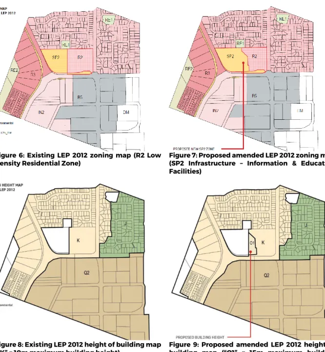
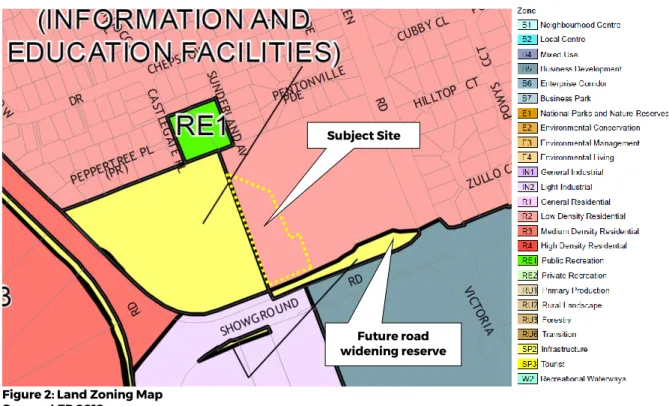
Support the growth and development of the arts and culture employment and skills sector in Western Sydney. Change the zone from R2 Low Density Residential Zone to SP2 Infrastructure (Information and Education Facilities) over part of the TAFE site. The existing zoning of the site is R2 Low Density Residential under the LEP 2012 as shown in Figure 2.
The existing use of the site is Castle Hill TAFE, which is banned in the R2 Low Density Residential Zone in LEP 2012, but benefits from existing use rights on the site. Nevertheless, it is noted that the use of the site as a TAFE facility is permitted under the provisions of the State Land Use (Educational Institutions and Childcare Facilities) 2017 Policy. In order to realize a new MDC building that will serve the purposes and proposed uses stated above, the rezoning of a portion of the TAFE site to SP2 infrastructure with the specific use listed on the amended zoning map as "Information and Education Facilities".
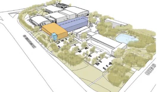
The intended outcome of this planning proposal is to enable the construction of a new permanent building for use by the MDC, required as a result of the development of the Powerhouse Museum at Parramatta by 2023, and to provide permanent additional collection, conservation and research facilities for the MDC on the site in a modern, purpose-built building.
Proposed Development
Public access to the proposed Building J will be limited to a pre-arranged booking basis for access to the collection for research purposes and small group visits. The existing publicly accessible areas on the MDC site will not be changed by the proposal.
Need for the Planning Proposal
Is the planning proposal a result of an endorsed local strategic planning statement, strategic
Is the Planning Proposal the best means of achieving the objectives or intended outcomes, or is
Relationship to Strategic Planning Framework
Will the planning proposal give effect to the objectives and actions of the applicable regional, or
Natural and cultural landscapes are protected. The proposed extension of the MDC contributes directly to the protection of the cultural landscape. The proposed building design will be informed by the setting and character of the existing buildings within the MDC and TAFE sites. The proposed new building J will be supported by new landscaping that will contribute positively to the appearance of the site.
The proposed development of the site will have an overall low impact on views obtained from the public. Opportunities for replanting within the "Green Grid Project Opportunities" will be explored during the development of the Tree Replacement Planting Strategy for the future DA for the site. The MDC and TAFE sites are located approximately 9.4 km east of the Western Sydney Parklands.
The Planning Proposal will provide enhanced facilities to support the continued operation of the MDC and the needs of the current and future population of the Hills Shire LGA. The Local Strategy adopted in 2008 is the Council's long-term strategy for the future of the Hills Shire community. To inform the drafting of the Local Environmental Plan and Development Control Plan for the Shire;
Is the Planning Proposal consistent with applicable State Environmental Planning Policies?
This Planning Proposal facilitates an extension to the existing site of the MDC, which is an important museum facility that contributes to the cultural character of the Hills Shire LGA. The purpose of the SEPP for State and Regional Development is to identify development that is of state importance. 52(4) A TAFE establishment (including any part of its premises and any premises thereof) may be used, with development consent, for the physical, social, cultural or intellectual development or welfare of the community, whether or not it is a commercial use of the establishment.
When drawing up an environmental planning instrument, a planning authority must not include in a particular zone (within the meaning of the instrument) any land specified in subsection a) the planning authority has considered whether the land is contaminated, and. Further assessment of the identified AEC and subsequent management/remediation of identified unacceptable soil contamination risks (if warranted) will be required to confirm the suitability of the land use (in relation to soil contamination) for the proposed redevelopment works." Furthermore, due to the nature of the construction, any residual soil will be covered with concrete, including the basement and ground floor, thus removing terrestrial ecological exposure pathways.
The proposed rezoning of the site to accommodate the future building J will be an acceptable use of the site and the planning proposal complies with the provisions of Article 6(1) of SEPP 55.
Is the Planning Proposal consistent with applicable Ministerial Directions (s.9.1 Directions)?
The site is not located in the North West Priority Growth Area and Direction 7.4 does not apply.
Environmental, Social and Economic Impacts
- Is there any likelihood that critical habitat or threatened species, populations or ecological
- Are there any other likely environmental effects as a result of the Planning Proposal and how are
- Has the planning proposal adequately addressed any social and economic effects?
- Other Environmental Effects
The proposed new building J, the subject of a future DA, will have the potential to impact the nearest residential sensitive receptors to the north of the site on Sunderland Avenue during construction and operation. To minimize noise impacts, the workshops will be located within building J at the southern end of the building, the farthest distance from the existing residential dwellings to the north of the site. The overall capital investment value of the redevelopment of the site is estimated at more than $30 million.
The site is currently underutilized and the proposal will utilize an undeveloped portion of the site without impacting on existing TAFE site operations and potential future expansion of the TAFE facility. The future DPA for the construction and use of the proposed Building J will be subject to the consent of TAFE as the landowner. Therefore, there is an existing development potential to expand TAFE to the north and northeast of the area to construct new buildings and facilities.
The proposed MDC extension therefore does not unacceptably restrict the possible future growth of the existing TAFE facilities on the site.
State and Commonwealth Interests
Is there adequate public infrastructure for the Planning Proposal?
Given the location of the site at the intersection of three main roads (Windsor Road, Showground Road and Green Road) the site enjoys a high level of both local and regional road accessibility, and access to public transport is available close to the site. Create Infrastructure recognizes the important educational function that TAFE serves to the community and the proposal has been developed in collaboration with input and approval from TAFE NSW as landowner and a key stakeholder. The proposal will not impede the ongoing operation nor will it affect any future potential for expansion of the TAFE site.
As a result of the proposed development of the new building, the TAFE site will have a total site area of approximately 30,480 m2, of which approximately 20,200 m2 will be landscaped/open space. The existing TAFE site is currently underutilized with approximately 5,300 m2 of total gross floor area for all buildings on the site, corresponding to an FSR of approximately 0.17:1. The south side of the TAFE site is also underutilized and could be developed with new buildings with parking in the basement levels or elsewhere on the site. F Block” (approved by the Council in 2007), the TAFE site has undergone limited expansion of existing educational facilities over the last 10 years and there is potential for expansion within the site which is not constrained by any FSR in LEP 2012, in particular pursuant to the provisions of Part 6 and Schedule 3 in the educational SEPP.
Opportunities for research, education, training and skills development synergies between the MDC and TAFE may be explored following the completion of Building J and further consultation between MAAS and TAFE NSW.
What are the views of the State and Commonwealth public authorities consulted in accordance
Community and public authority consultation will be undertaken in accordance with the statutory consultation provisions for rezoning and development applications. It is expected that a public exhibition period of 14 days will be required and will be detailed in the Gateway provision. It is essential that the new "Building J" be completed before the relocation of the Powerhouse Museum to Parramatta in 2023.
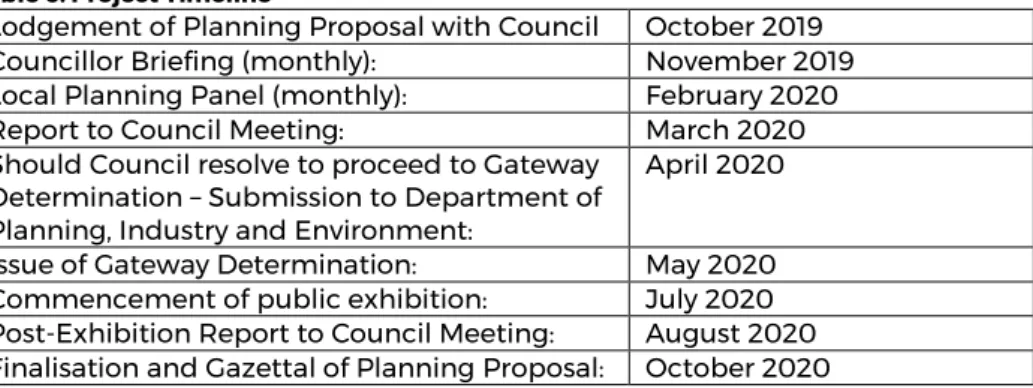
Planning Proposal to Council October October 2019 Councilor Briefing (Monthly): November 2019 Local Planning Panel (Monthly): February 2020 Gateway Designation EMSTIA: May 2020 Public Exhibition Commencement: July 2020 Post Exhibition Report to Council Meeting: August 2020 Planning Proposal Finalization and Gazetteer: October 2020.