REGIONAL RAIL LINK SECTION 2 NOISE IMPACTS AND MITIGATION
ADVISORY COMMITTEE REPORT
23 JANUARY 2012
REGIONAL RAIL LINK SECTION 2 NOISE IMPACTS AND MITIGATION
ADVISORY COMMITTEE REPORT
……….………
Jennifer A Moles, Chair
……….………
Colin Burns, Member
……….………
Doug Munro, Member
...
Robin Saunders, Member
23 January 2012
REGIONAL RAIL LINK SECTION 2: NOISE IMPACTS AND MITIGATION
Contents
1. SUMMARY ... 1
2. BACKGROUND ... 9
2.1 The Regional Rail Link Project ... 9
2.1.1 The project in detail ... 9
2.1.2 Operational detail ... 13
2.2 The route and surrounds ... 15
2.2.1 Land form ... 15
2.2.2 Land ownership ... 15
2.2.3 Current land use and zoning ... 15
2.2.4 Future land use and development ... 18
2.2.5 Biodiversity and Aboriginal cultural impact management ... 20
2.3 Referral of the project under the Environment Effects Act ... 23
2.4 Statutory processing of RRL2 ... 24
2.4.1 Panel comment ... 25
2.5 The Advisory Committee process ... 27
2.5.1 Appointment ... 27
2.5.2 Terms of Reference ... 27
2.5.3 Deferral of commencement of Advisory Committee process ... 28
2.5.4 Call for submissions ... 28
2.5.5 Written submissions ... 28
2.5.6 Issues raised in written submissions ... 29
2.5.7 Advisory Committee hearings ... 30
2.5.8 Inspections ... 32
2.5.9 Further information requested ... 33
2.5.10 Ministerial qualifications to Terms of Reference ... 33
2.5.11 The Advisory Committee report ... 35
3. THE PROJECT TO BE ASSESSED ... 36
3.1 The issue ... 36
3.2 Noise Impact Management Report ... 36
3.3 Evidence and submissions ... 37
3.4 Discussion ... 40
3.4.1 Proposed elements for regional passenger rail not included in initial construction ... 42
3.4.2 Possible elements not directly related to regional passenger rail ... 43
3.4.3 Possible project elements not envisaged at the time of the EES referral ... 45
3.5 Conclusions and recommendations ... 46
4. POLICY CONTEXT ... 47
4.1 Objectives of the Planning and Environment Act ... 47
4.2 State Planning Policy Framework ... 47
4.3 Transport Integration Act 2010 ... 50
4.4 Draft Government Policy Framework ... 52
4.5 Panel comment on policy context ... 54
5. CONSTRUCTION NOISE AND VIBRATION ... 56
5.1 What are the issues? ... 56
5.2 Construction noise ... 57
5.2.1 Standards ... 57
5.2.2 Impact assessment ... 60
5.2.3 Additional noise mitigation measures ... 65
5.2.4 Implementation ... 65
5.3 Construction vibration ... 69
5.3.1 Standards ... 69
5.3.2 Impact assessment ... 70
5.3.3 Additional mitigation measures ... 71
5.3.4 Implementation ... 71
5.4 Impacts of blasting ... 72
5.4.1 72 5.4.2 Impact assessment ... 75
5.4.3 Additional mitigation measures ... 77
5.4.4 Implementation ... 77
5.5 Operational vibration ... 79
5.5.1 Standards ... 79
5.5.2 Impact assessment ... 79
5.5.3 Additional mitigation measures ... 81
5.5.4 Implementation ... 81
5.6 Conclusions and recommendations ... 81
6. OPERATIONAL NOISE STANDARDS ... 85
6.1 What are the issues? ... 85
6.2 Noise Impact Management Report ... 85
6.2.1 Train operation ... 85
6.2.2 Railway infrastructure ... 86
6.2.3 Road traffic ... 86
6.2.4 Peer review ... 86
6.3 Evidence and submissions ... 87
6.3.1 Train operation ... 87
6.3.2 Railway infrastructure ... 94
6.3.3 Road traffic noise ... 95
6.4 Discussion ... 95
6.4.1 Peer review ... 95
6.4.2 Train operation ... 95
6.4.3 Railway infrastructure ... 101
6.4.4 Noise from road traffic ... 103
6.5 Conclusions and recommendations ... 104
7. ASSESSMENT OF OPERATIONAL NOISE IMPACTS ... 106
7.1 What are the issues? ... 106
7.2 Noise Impact Management Report ... 106
7.2.1 Train noise ... 106
7.2.2 Railway infrastructure ... 108
7.2.3 Peer review ... 108
7.3 Evidence and submissions ... 109
7.3.1 Train noise ... 109
7.3.2 Railway infrastructure ... 115
7.3.3 Road traffic noise ... 115
7.4 Discussion ... 117
7.4.1 Peer review ... 117
7.4.2 Adequacy of operational noise level predictions ... 117
7.4.3 Adequacy of operational noise impact assessment ... 128
7.4.4 Acceptability of residual operational noise ... 131
7.5 Conclusions and recommendations ... 131
8. MITIGATION OF OPERATIONAL NOISE IMPACTS ... 134
8.1 What are the issues? ... 134
8.2 Noise Impact Management Report ... 134
8.2.1 Available mitigation measures ... 134
8.2.2 Acoustic benefits and costs of measures ... 136
8.3 Evidence and submissions ... 136
8.3.1 Available mitigation measures ... 136
8.3.2 Acoustic benefits and costs of mitigation measures ... 142
8.4 Discussion ... 145
8.4.1 Available mitigation measures ... 145
REGIONAL RAIL LINK SECTION 2: NOISE IMPACTS AND MITIGATION
8.4.2 Acoustic benefits and costs of measures ... 151
8.5 Conclusions and recommendations ... 155
9. IMPLEMENTATION OF OPERATIONAL NOISE MITIGATION ... 157
9.1 What are the issues? ... 157
9.2 Who should pay for noise mitigation? ... 158
9.3 Train Noise ... 161
9.3.1 Selection of noise mitigation measures ... 161
9.3.2 Overall process to produce the FNMP and the DDO. ... 167
9.3.3 The process for identification of additional noise mitigation measures ... 168
9.4 Railway infrastructure ... 172
9.5 Road traffic noise ... 173
9.6 Performance monitoring ... 173
9.7 Responsibility for implementation of the FNMP ... 174
9.8 Noise mitigation at dwellings ... 178
9.8.1 The form of the DDO ... 180
9.8.2 Paying for architectural treatments ... 185
9.9 Conclusions and recommendations ... 186
10. GENERAL CONCLUSIONS AND RECOMMENDATIONS ... 191
10.1 Conclusions ... 191
10.2 Recommendations ... 193
10.3 Committee comment: ... 194
APPENDIX 1: MINISTER’S DECISION UNDER ENVIRONMENTAL EFFECTS ACT RE RRL2 ... 196
APPENDIX 2: INCORPORATED DOCUMENT AT CLAUSE 52.03 OF THE WYNDHAM PLANNING SCHEME ... 199
APPENDIX 3: ADVISORY COMMITTEE TERMS OF REFERENCE ... 203
APPENDIX 4: DRAFT POLICY FRAMEWORK FOR PASSENGER RAIL NOISE ... 208
APPENDIX 5: PUBLIC ADVERTISEMENT CALLING FOR SUBMISSIONS ... 214
APPENDIX 6: SUMMARY OF INDIVIDUAL WRITTEN SUBMISSIONS IN RESPONSE TO PUBLIC NOTICE ... 215
APPENDIX 7: ADVISORY COMMITTEE DIRECTIONS OF 30 SEPTEMBER 2011 .... 224
APPENDIX 8: EXHIBITS FROM ADVISORY COMMITTEE HEARING ... 231
APPENDIX 9: CORRESPONDENCE CONCERNING REPORT SUBMISSION DATE AND TERMS OF REFERENCE ... 238
Abbreviations
Exhibited Documents
DNMP
Noise Management Plan Rev G, 9 December 2010, KBR‐Arup (referred to by us as a draft plan to distinguish it from the final plan (FNMP) recommended)
NIMR Noise Impact Management Report Rev H, 10 December 2010, KBR‐
Arup Reference Documents
ANZECC Guidelines
Technical basis for guidelines to minimise annoyance due to blasting overpressure and ground vibration, September 1990, Australian and New Zealand Environment Conservation Council
AS 2187 Australian Standard 2187.2‐2000 Explosives – Storage, transport and use, Part 2 Use of Explosives, Standards Australia
AS 2377‐2002 Australian Standard AS 2377‐2002 Acoustics ‐ Methods for the measurement of railbound vehicle noise, Standards Australia DGPF Draft Government Policy Framework for Noise from Future Rail
Investment in Victoria, August 2011, Department of Transport IGANRIP
Interim Guideline for the Assessment of Noise from Rail
Infrastructure, 2007, NSW Department of Environment and Climate Change
NCG 1254 Noise Control Guidelines, Publication 1254, October 2008, EPA NSW CNS Construction Noise Strategy (Rail Projects) ‐ NSW Transport
Infrastructure Development Corporation
NSW ECRTN Environmental Criteria for Road Traffic Noise, May 1999, Environment Protection Authority NSW
NSW Rail Noise Data Base
Rail Noise Database: State 11 Noise Measurements and Analysis Report 00091 Version A, August 2000, Rail Access Corporation NSW
section 251B section 251B of the Transport (Compliance and Miscellaneous) Act 1983
SEPP N‐1 State Environment Protection Policy (Control of Noise from Commerce Industry and Trade) No. N‐1
SEPP N‐2 State Environment Protection Policy (Control of Music Noise from Public Premises) No. N‐2
REGIONAL RAIL LINK SECTION 2: NOISE IMPACTS AND MITIGATION
VicRoads
Noise Policy VicRoads Traffic Noise Reduction Policy, 2005, VicRoads
VicRoads DN06
VicRoads Road Design Note RDN 06‐01, Interpretation and Application of VicRoads Traffic Noise Reduction Policy, 2005,VicRoads
WHO Guidelines
Guidelines for Community Noise ‐ Beglund, B., Lindvall, T. and Schwela, D.H. (eds), 1999, World Health Organisation Other Documents
FNIMR Final Noise Impact Management Report FNMP Final Noise Management Plan
Victorian Government
AAV Aboriginal Affairs Victoria DoT Department of Transport
DPCD Department of Planning and Community Development DSE Department of Sustainability and Environment
EPA Environment Protection Authority Victoria GAA Growth Areas Authority
VCAT Victorian Civil and Administrative Tribunal VicTrack Victorian Rail Track Corporation
RRLA Regional Rail Link Authority Companies and Groups
KBR‐Arup KBR Arup Joint Venture MDA Marshall Day Acoustics
PTO Public Transport Ombudsman
Dennis Family The Dennis Family Corporation, Manor Commercial Company Pty Ltd & Manor Lakes (Werribee) Pty Ltd
Planning Scheme Terms
B3Z Business 3 Zone
ESO Environmental Significance Overlay
FZ Farming Zone
IN1Z Industrial 1 Zone
PAO Public Acquisition Overlay PPRZ Public Park and Recreation Zone PSP Precinct Structure Plan
PUZ Public Use Zone
R1Z Residential 1 Zone
RCZ Rural Conservation Zone
RDZ Road Zone
SPPF State Planning Policy Framework SUZ Special Use Zone
UFZ Urban Floodway Zone UGB Urban Growth Boundary UGZ Urban Growth Zone Other
CHMP Cultural Heritage Management Plan DMU Diesel Multiple Unit train e.g. VLocity EES Environment Effects Statement
EMU Electrical Multiple Unit train as used for metropolitan services RRL1 Regional Rail Link Section 1
RRL2 Regional Rail Link Section 2
SEPP State Environment Protection Policy
Continuous Apartments
A building or series of buildings (probably of two or more storeys) containing noise protected apartments or townhouses built on or immediately adjacent to the project area boundary, with external living areas located away from the project area and providing a complete barrier to railway noise for development further away from the railway.
Frontage Road
Development layout involving detached dwellings facing onto the project area and separated from it by a street with a landscaped area on the railway side and a conventional footpath and nature strip on the housing side, and with a 25m setback assumed between the project area and the front façade of dwellings
Rear Exposure
Development layout involving detached houses backing onto the project area, with external living areas at the rear, and 5‐6m clearance between the project area and the rear of dwellings
REGIONAL RAIL LINK SECTION 2: NOISE IMPACTS AND MITIGATION
Glossary
dB Abbreviation for ‘decibel’, which is a measure of sound pressure level, i.e. noise level
ʹAʹ weighting Method of frequency weighting of noise to simulate the way the
human ear responds to a range of acoustic frequencies
dB(A) ‘A’ weighted noise level commonly used for assessment of noise impacts on people
Façade
correction An adjustment of +2.5 dB(A) made to a noise reading at a site to
represent what the noise level would be with a building present.
Hz Hertz, the unit of frequency, in cycles per second
LAeqT The equivalent continuous (average) ‘A’ weighted noise level over time period T
LAeq15h(day)
The LAeq noise level for the period 7:00 to 22:00 hours,
commonly used for assessment of noise from railways during the ʹdayʹ
LAeq9h(night)
The LAeq noise level for the period 22:00 to 7:00 hours,
commonly used for assessment of noise from railways during the ʹnightʹ
LAeq16h(day) The LAeq noise level for the period 6:00 to 22:00 hours, used in the WHO Guidelines for assessment of noise during the ʹdayʹ LAeq8h(night) The LAeq noise level for the period 22:00 to 6:00 hours, used in
the WHO Guidelines for assessment of noise during the ʹnightʹ LAeq24h The LAeq noise level for a 24 hour period, used in some
jurisdictions for assessment of noise from railways
LAeq1h The LAeq noise level for a one hour period, used in New Zealand for assessment of noise from railways
LA90
The ‘A’ weighted sound pressure level that is exceeded for 90%
of a time period, specified in SEPP N‐1 for the measurement of background noise level
LA10 The ‘A’ weighted sound pressure level that is exceeded for 10%
of a time period
LA10,18h The LA10 for the period from 6:00 to 24:00, used by VicRoads for assessment of road traffic noise
PPV Peak amplitude of vibration (Peak Particle Velocity), usually in mm/s
RMS Average amplitude of vibration (Root Mean Square velocity), usually in mm/s
ʹLʹ weighting Linear weighting of noise, i.e. no frequency based adjustment
dB(L) ʹLʹ weighted sound pressure level commonly used for assessment of airblast overpressure from blasting
1. Summary
This Advisory Committee was appointed to assess the noise impacts and recommend required mitigation responses for Section 2 of the Regional Rail Link Project.
Regional Rail Link Section 2
What is proposed is a new railway of approximately 30 kilometres long that will run between west of Werribee and Deer Park, providing a north‐south connection between the Ballarat Rail Corridor and the Geelong Rail Corridor.
The new railway will enable the diversion of regional Geelong rail services away from the track now shared with metropolitan passenger services on the Werribee line and connect them into the Ballarat regional line at Deer Park.
The Regional Rail Link Project Section 1 (RRL1) will allow the trains to continue to Southern Cross Station along new dedicated regional rail tracks adjacent to the existing tracks which will continue to accommodate metropolitan passenger services.
The Regional Rail Link Project overall (Sections 1 and 2) will provide the benefits both of allowing regional trains faster access to central Melbourne as they will not be held up by stopping suburban trains and of freeing additional capacity on the suburban network.
Section 2 of the project will also offer local passenger service benefits to the developing suburbs along its route, such as Truganina, Tarneit and Wyndham Vale, with two stations proposed to service the growth areas in the short term and five in the longer term.
EES referral requirements
When Section 2 of the project was referred to the Minister for Planning for a decision as to whether an Environment Effects Statement (EES) was required to be prepared under the Environmental Effects Act 1978, the Minister determined that no EES was required subject to a number of requirements being met, most notably:
The proponent, the Department of Transport (now the proponent is in effect the Regional Rail Link Authority (RRLA)), was required to prepare a noise impact management report (NIMR), containing a noise management plan (DNMP) before the project works could begin.
The NIMR with its incorporated DNMP was later prepared for the RRLA by a consortium known as KBR Arup Joint Venture (KBR‐Arup).
An expert advisory committee was required to be appointed by the Minister to:
o consider the NIMR and public submissions in response o consult with submitters and relevant agencies and experts
o provide a report including recommendations to the Minister to inform the Minister’s decision on the endorsement of a final noise impact management plan.
This report is provided in compliance with those requirements and the terms of reference which were provided to the Committee.
Public submissions and hearings by the Advisory Committee
The Advisory Committee advertised for public submissions and 15 written submissions were received in response. Most submissions were from major landowners or developers with interests in future urban land along the route. We conducted a public hearing at which all but one of the submitters made presentations and many parties called expert acoustic evidence. The RRLA also made a presentation and called the author of the NIMR and DNMP to give expert evidence. We were also presented with views and information (some of this actively sought out by the Committee) from a number of government agencies.
This report
Our report is presented in a number of chapters:
Chapter 1 is this summary
Chapter 2 deals with background matters
Chapter 3 discusses the definition of the project
Chapter 4 provides the policy context for our considerations
Chapter 5 deals with construction noise, and vibration both during construction and the operational phase
Chapter 6 establishes recommended operational noise standards
Chapter 7 assesses the operational noise impacts
Chapter 8 discusses the operational noise mitigation options
Chapter 9 discusses and makes recommendations concerning further steps in noise mitigation implementation including the completion of the
‘Final Noise Management Plan’
Chapter 10 contains consolidated conclusions and recommendations.
Advisory Committee comment on its task
The urban areas of this State and in particular the metropolitan area are
place for well over a century. While railways create noise which can affect the amenity of adjoining residential areas, this has generally not created major problems. In part this is because the railways have been there as long as the housing and in part because rail noise is relatively low on the scale of noise annoyances for the community. It may also be because of the railways are accepted as important for moving people and goods. Importantly, the community response will be determined in large measure by the absolute level of the noise.
The operational noise which will be generated by this project is expected to be considerably higher than the noise generated by most other existing urban rail systems. This is due in the main to the fact that trains will be travelling much faster through the urban area than they do at present. Speeds up to 160km/h are expected. Trains on the lower speed, electrified metropolitan system generate considerably less noise. Also while diesel‐powered trains as will be used here (including those carrying freight) do already pass through the urban areas, they generally travel at much lower speeds than is proposed for RRL2.
This new railway is to be located in an area subject to rapid urbanisation.
While some existing housing abuts the project area for RRL2, it is proposed that, within a few decades, along perhaps half of its length, there will be thousands more nearby dwellings. We have established that much of this housing could be expected to experience unacceptable levels of train noise without mitigation measures beyond the very limited noise amelioration proposals by RRLA being put in place. The simultaneous development of the rail line and the housing has presented particular challenges in determining how best to deal with noise mitigation.
Despite the further problem presented to the Committee by inadequate information about several key aspects of the rail project, we have been able to make a number of findings and recommendations on how to deal with the noise issue.
Before setting out our key findings and recommendations, we would comment that there are only a limited number of broad policy responses which might be taken to the high levels of operational noise from this railway:
An objective might be set of containing all noise to the project area. To achieve this, a combination of quite deep cuttings, and bunds and barriers perhaps of 6m in height, would be required along much of the length of the project area boundary or alternatively substantial train speed reductions would have to be imposed. Cuttings for reasons of acoustic attenuation alone would be very costly; bunds and barriers of that height for such a distance are likely to be visually unattractive and incompatible
with urban design intents; substantial reductions in train speed to below 40km/h as would be required for large distances would be incompatible with the planned function of RRL2.
A satisfactory noise environment for dwellings might be achieved by nothing more than imposing a nominated separation distance between the housing and rail line. In the absence of any other mitigation measures, the buffer on each side of the railway would need to be some 200 m or more. Whether or not this land area of approximately six square kilometres would be publicly acquired, the developable land loss would be untenable. Also this arrangement would inappropriately reduce convenient access by households to the rail services offered by the line.
Alternatively, acoustic treatments of the dwellings themselves might be required. While, in the absence of any noise mitigation at source, quite extensive treatments may be needed to possibly many thousands of dwellings, this would or could achieve acceptable indoor noise levels.
There would be some internal amenity implications for these dwellings (such as requiring forced ventilation) and, more importantly, the even higher noise levels occurring outside at those properties would not be abated.
We believe that the appropriate approach is one that draws on aspects of the above broad approaches. Our recommendations are that noise mitigation should involve:
on‐site measures including a final vertical alignment for the railway optimised in response not only to engineering but also to noise considerations, as well as barriers and bunds of modest height and possibly some limited speed restrictions; and
planning responses including modest separation distances between the housing and the project area where the buffer can be usefully deployed for other land use purposes; housing arrangements whereby a closely built line of detached dwellings or an apartment building or terrace provides an acoustic barrier to dwellings further from the project area;
and acoustic treatments of dwellings where needed.
Deployment of various mitigation measures enables a designed response to be made to the different characteristics and circumstances along the length of the railway. The opportunity for an integrated approach to land use and transport is afforded as well as the achievement of the most cost‐effective outcome.
Key findings and recommendations
The following points summarise some of the principal findings and recommendations of the Advisory Committee.
The project addressed in the NIMR and presented to the Advisory Committee for assessment by RRLA is not the complete project included in the EES referral and considered by the Minister under the Environmental Effects Act. We recommend that a more comprehensive analysis of the project involving the assessment of all future train traffic and noise sources is required. Other adjustments to the projection assessment methodology are also required.
The noise projections by the proponent as reported in the NIMR (even for the limited project addressed) have not been translated into noise impacts to be addressed in the DNMP. There is no identification of the extent of outdoor and indoor amenity impacts for sensitive uses.
The NMIR and the DNMP fail to deal reasonably and rationally with the operational noise impacts anticipated. Minimal noise mitigation at source is proposed and off‐site noise levels well above acceptable residential acoustic targets will occur. The RRLA has indicated a preparedness to accept financial responsibility for mitigating noise for existing dwellings only.
To the extent that this was intended to result in adjoining landowners themselves having to assume responsibility for mitigation of the noise impacts for new dwellings, the RRLA approach appears to have overlooked the relevant legislative framework for compensation for disaffection. Under that legislative framework it would appear that the cost of mitigation will effectively have to be assumed by the project proponent/State even if the off‐site works were to be undertaken by the owners of the affected adjoining land.
To the extent that the proponent’s response has been led by the exemptions for operational train noise from nuisance actions and certain specified legislative obligations provided in section 251B of the Transport (Compliance and Miscellaneous) Act 1983, this is to overlook the Minister’s intent that unacceptable noise should be mitigated via a FNMP for the project. Common law actions in nuisance and the two specified Acts and their subordinate instruments may not apply to train noise, but section 251B does not preclude other management or enforcement arrangements being put in place to deal with operational train noise such as the FNMP.
That plan itself may include compliance obligations. If necessary, compliance could also be ensured via the Incorporated Document of the planning schemes.
We recommend that the following be set as the operational noise standards for this project:
External noise targets at dwellings:
Day Time (7:00-22:00) 60 dB LAeq15h(day)
Night Time (22:00-7:00) 55 dB LAeq9h(night)
24 Hours 80 dB LAmax Internal noise limits for dwellings:
Living areas
Day time (7:00-22:00) 45 dB LAeq15h(day) Night time (22:00-7:00) 45 dB LAeq9h(night) 24 hours 65 dB LAmax Bedrooms
Day time (7:00-22:00) 45 dB LAeq15h(day) Night time (22:00-7:00) 40 dB LAeq9h(night)
24 hours 65 dB LAmax
These standards have been developed:
o Following a review of rail noise standards adopted elsewhere and follow the guideline levels for external noise from new railways applying generally in New South Wales.
o Taking into account both internal and external amenity impacts for sensitive uses and allowing for consideration to be given to either external noise mitigation measures such as noise barriers or internal noise mitigation measures such as double glazing in particular locations as circumstances warrant.
We recommend that the noise standards apply to existing housing, lots for which subdivision approval has been granted, and for future dwellings in the Precinct Structure Plan areas adjacent to the railway.
Our recommendations have been developed taking into account the fact that the railway and the adjoining housing areas are being developed in the same time frame.
Some 1500 future dwellings are proposed to be located immediately adjacent to the project area with thousands of other future dwellings proposed close by. Without noise mitigation, operational noise impacts exceeding the recommended external noise targets can be expected at the closest dwellings to the project area as well as many of the others.
Despite the adoption of a noise standard for the project, we have not been able to recommend the detailed content of the FNMP as it relates to the specific noise mitigation measures to be applied along sections of the project area. Rather we have made recommendations as to a further process to move towards the choice of mitigation measures and the required content of the final plan.
The alignment available for our assessment was a ‘reference design’ only.
We understand there have been recent changes to that alignment by the construction contractor, based on additional engineering considerations.
We believe that there is a need to further review the vertical alignment to
This revised vertical alignment will then be used as an input to remodelling of revised operational noise predictions and acoustic impacts. The recalculation of predictions and impacts also needs to take into account improved source train noise inputs, the volumes and types of all reasonably‐foreseeable future traffic on the project area, other elements of the acoustic environment not yet modelled such as horns and railway infrastructure noise, as well as planned and committed abutting land use.
The objective of the review should be to more accurately identify the noise impacts of the project. It will then allow the identification of the most cost effective on‐site acoustic mitigation measures for sections of the project area within the framework set by the recommended external acoustic targets for dwellings.
Practicability considerations relating to on‐site mitigation are expected to result in some residual noise impacts outside the project area. These will need to be managed through planning approaches involving the GAA and municipalities. These would include land use arrangements in new housing areas along the track whereby less sensitive uses would occupy the areas closest to the project area for some sections of its length, and the first housing to be developed in a subdivision or development area would be that closest to the track so as to acoustically shield housing further away. Architectural treatments (sound insulation and special ventilation arrangements as necessary) will also be required in some places to address the residual noise impacts at dwellings.
A Design and Development Overlay is recommended as the appropriate planning mechanism.
We have included an analysis of the costs and acoustic effectiveness of different types of acoustic measures to assist in the choice of measures and we have also suggested an approach to assist in identifying where mitigation on the project area is or is not practicable.
We nevertheless endorse the attenuation of noise at source as the most efficient and effective means to ameliorate operational noise problems for nearby sensitive uses via the use of cuts, low barriers and bunds.
Careful on‐going track and wheel maintenance are elements of the required operational noise management regime, and speed restrictions may also play a part.
We also recommend that a noise monitoring and auditing system needs to be put in place.
We are satisfied that for the most part construction noise and vibration as well as operational vibration either do not present problems for nearby sensitive land uses or can be adequately managed under arrangements specified in the FNMP.
The FMNP also needs to manage noise from railway infrastructure by setting limits for that additional noise.
Adoption of our key recommendation that further work needs to be undertaken before the final NIMR and final NMP are approved will necessarily delay approval of these key documents relating to noise management. Given the requirement in the Minister’s decision on the EES referral that the approval of the FNMP must precede commencement of works, this has implications for the commencement of construction of the railway.
The Advisory Committee is aware that a contract for construction of RRL2 has now been entered into. The further work we recommend is expected to result in further changes to the vertical alignment of the railway1. These, together with the inclusion of additional noise mitigation works within the project area, will likely necessitate construction contract variations.
While immediate progress on the project’s implementation may be constrained, we believe that the recommended further work can be done expeditiously within the framework of implementation we have suggested.
We believe that the further work recommended is critical to achieving a project outcome which fairly deals with the noise impacts, will be less costly in the long run, and will provide a better living environment for the thousands of future residents along the railway.
2. Background
This is the report of the ’Noise Impacts of Regional Rail Link Section 2 ‐ West of Werribee to Deer Park Advisory Committee’ appointed by the Minister for Planning. Throughout this report, the simpler term of ‘Advisory Committee’
or ‘Committee’ is used.
The report deals with the noise impacts and mitigation responses associated with the approved alignment for Regional Rail Link Section 2 ‐ West of Werribee to Deer Park (RRL2).
2.1 The Regional Rail Link Project
RRL2 is a new railway of approximately 30 kilometres long that will run between west of Werribee and Deer Park, providing a north‐south
connection between the Ballarat Rail Corridor and the Geelong Rail Corridor.
The new railway will enable the diversion of regional Geelong rail services away from the track now shared with metropolitan passenger services on the Werribee line and connect them into the Ballarat regional line at Deer Park.
The Regional Rail Link Project Section 1 (RRL1) will allow the trains to continue to Southern Cross Station along new dedicated regional rail tracks adjacent to the existing tracks which will continue to accommodate metropolitan passenger services.
The Regional Rail Link Project overall (Sections 1 and 2) is said to provide the benefits both of allowing regional trains faster access to central Melbourne as they will not be held up by stopping suburban trains and of freeing additional capacity on the suburban network.
Section 2 of the project will also offer local passenger service benefits to the developing suburbs along its route, such as Truganina, Tarneit and Wyndham Vale, with two stations proposed to service the growth areas in the short term and five in the longer term.
2.1.1 The project in detail
The project was referred by the Director of Public Transport to the former Minister for Planning on 17 June 2009 for a decision on the need for assessment under the Environment Effects Act 1978 (EES referral) 2.
2 Referral document is entitled: ‘Referral of a project for a decision on the need for assessment under the Environmental Effects Act 1978’, 2 June 2009
The summary description of the project given in the EES referral is:
· A two track railway with the potential in the longer term for expansion to a four track railway for most of the route
· Stations and associated infrastructure such as car parking
· Grade separations at road intersections
· Train stabling yards.
The EES referral also describes the major components of the project in greater detail.
The project area
The EES referral describes the approximately 30 km long corridor that is being acquired as generally of 60m in width but wider at a number of locations to accommodate grade separated road bridges, waterway crossings, stations including car parking and bus stations, and train stabling. It includes that through Wyndham Vale it will share an existing 75m transport corridor with the proposed parallel four lane Armstrong Road.
The built infrastructure
The track arrangement is described as initially having two tracks to carry regional passenger trains. These two tracks would provide a connection between the two track railway in the Ballarat Rail Corridor just west of Deer Park station and the two track Geelong Rail Corridor to the west of Werribee station. It is indicated that, depending on surrounding urban development, two further tracks would be built in stages between near Middle Road, Ravenhall, to north of the Werribee River in Tarneit3. These additional tracks will allow so called short starter services to run between Southern Cross and Wyndham Vale stations. We understand that this will allow some express services and increase the capacity of RRL2 to accommodate growing demand from this developing urban area.
Initially stations will be provided at Tarneit and Wyndham Vale. Exhibits provided to the Advisory Committee at its hearing of the proposed layout of these two stations show them being designed for an initial two tracks with associated transport interchanges and car parking and with provision for two further tracks. The EES referral notes that land is provided in the reservation for future stations, identified to the Advisory Committee as Truganina, Davis Road and Sayers Road that can be built in response to urban growth in the surrounding areas.
The EES referral indicates that bridges will be built to grade separate the railway from existing or future arterial roads. The Advisory Committee understands that, consistent with Government policy there are to be no rail/road level crossings.
Watercourse crossings are described as being needed at several locations, but particularly over the Werribee River, Laverton Creek4, Skeleton Creek, Davis Creek, Lollypop Creek and their tributaries. The railway is variously described as crossing 36 or 19 waterways (both named and unnamed) and dams within the catchments of the above streams. These waterway crossings will necessarily be elevated to avoid flood levels and so as to not adversely affect the hydrology of those waterways.
The document states that most of RRL2 will be constructed at or near natural surface level but that the vertical alignment will be subject to detailed design.
It refers to the railway line being located in cuttings passing under the Western Freeway Deer Park Bypass at Ravenhall and through Wyndham Vale. The vertical alignment of the track, which has a major influence on noise predictions, has in recent months been reconsidered (though apparently not in relation to noise consequences) under the tendering process by construction companies.
The EES referral describes the probable construction at a later stage than the initial development, and depending on patronage, of a stabling area for regional (V/Line) trains between Greens and Black Forest Roads in Wyndham Vale. It is said that this facility would accommodate five 8 carriage trains for the short starter services mentioned earlier and would provide stabling, basic cleaning and depot facilities.
The possibility of eventual freight use is mentioned and provision is made for two freight tracks between the junction with the Ballarat Rail Corridor at Deer Park and Truganina (about 4–5 km to the south) for access to a possible intermodal freight terminal.
Lastly the EES referral advises of provision for the possible extension of the electrified metropolitan train service that at present terminates at Werribee.
The proposal is that the existing Werribee train service would be extended further along the Geelong rail corridor for a distance of about 4 km to then branch northward to run in parallel with the two RRL2 tracks at the eastern side of the same corridor. A railway station, Wyndham Vale South, served only by the metropolitan trains, would also be constructed near Black Forest Road. This service would extend to Wyndham Vale station which would therefore then be served by both metropolitan and regional trains.
4 We believe this is has been confused with Dohertys Creek.
This extension to metropolitan services would ultimately require train stabling, cleaning and depot facilities. An area to the north of Ballan Road within the project area has been nominated for this. It has a capacity of thirty 6 carriage electric trains. It is aid that this extension would create a four5 track railway between Ballan Road and about 2 km south of Black Forest Road.
Other project elements
The EES referral also lists a number of further elements that may be part of the project6. Some of these have or potentially have noise implications. They include:
The implementation of a Construction Environment Management Plan
‘Investigate, during detailed design, design outcomes of the railway that can reduce potential noise impacts, eg. putting the rail below natural surface level where it does not compromise the operational or drainage performance of the railway’ (our emphasis)
Encouraging appropriate future urban land uses to buffer noise impacts
and ensuring development of sensitive uses near the project contain adequate noise attenuation measures
Implementation of an urban design program that links in with the detailed design of the rail corridor to deal with visual amenity impacts and physical barriers at key locations where road and/or rail bridges impact on private or public spaces – especially at activity centres, heritage sites and dwellings
Advisory Committee comment
The major and other elements of the project above drawn from the EES referral have the following relationship to noise emissions:
The chosen corridor to a large extent fixes the horizontal alignment of RRL2 ‐ a basic element in determining noise outcomes for present and prospective nearby sensitive land uses
The noise generated by the use of railway infrastructure is subject to separate legislative requirements from that applying to rail operations
Particular noise management issues arise from the road overpasses provided in accordance with government policy. Elevation of the road traffic will increase its noise impact relative to that which would occur if the road was at grade.
The installation and effectiveness of required noise mitigation works within the project area at or near waterway crossings present
5 Actually six tracks.
considerable design difficulties, and if implemented are anticipated to be costly
The vertical alignment of the track is a major influence on noise emissions and depressing the rail alignment can have major acoustic benefits
Particular regulatory issues around the noise of stabling yard activities were drawn to the attention of the Committee
The noise consequences of possible freight traffic on RRL2 received only scant attention
Land use buffers, including the contribution to setbacks to housing by the shared pathway along the track and the use of noise mitigation works to dwellings are mentioned.
The Advisory Committee would observe that the EES referral says little on noise, but does recognise that there will be an increase in noise for residents close to the railway line from construction and operation, and from vibration during construction. Acknowledging that this is a new rail corridor which has therefore not previously experienced rail noise, the referral document indicates a preparedness to contemplate noise mitigation measures.
2.1.2 Operational detail
The EES referral contains no information about the proposed use of the line – the proposed engine types, train lengths, frequency of service, timetabling, etc. These are critical to assessment of the noise impacts of the railway and form part of the NIMR and DNMP required by the Minister’s decision on the referral.
To understand what is proposed in terms of railway operations, the Committee has drawn upon the material in the NIMR prepared on behalf of the proponent.
Train types
V/Line, the operator of passenger rail services expected to use the corridor, utilises a number of train types, but two will predominate:
The greatest number of passenger services will utilise VLocity diesel multiple units (DMUs). Units are generally powered by an underfloor diesel motor and can be coupled to form a multiple carriage train.
VLocities typically operate as 3 or 6 car units but can comprise up to 8 cars. These are new rail vehicles of which V/Line now has about 130. They are approved to run on much of the fast regional rail system at up to 160 km/h.
Trains comprising locomotive‐hauled passenger carriages ‐ hauled by N class diesel‐electric locomotives. These typically have 4 or more carriages.
This class of locomotives was commissioned in about 1985. These trains are permitted to run at speeds of up to 115 km/h.
Other passenger train types that might operate in the corridor are Sprinter DMUs with a maximum permitted speed of 130 km/h; and trains hauled by P class locomotives with a maximum permitted speed of 100 km/h or A class locomotives.
The noise predictions for 2014 assume the use of VLocity and Sprinter DMUs and trains hauled by N and P class locomotives. For 2030 the predictions are premised on locomotive‐hauled trains having been phased out and the service being operated by VLocities and Sprinters. Trains up to a maximum length of eight cars are anticipated to use the route.
Train numbers
The NIMP draws on the Regional Rail Link Rail Capacity Upgrade Phases report and for modelling purposes presents the number of trains per hour during the day and night for 2014 and 2030.
About 55 trains each way each weekday (about 45 during the day and 10 at night) between Southern Cross Station and Geelong on RRL2 are indicated for 2014 compared with 30 trains currently using the Werribee to Geelong line.
For 2030 the number of services between Southern Cross Station and Geelong remains unaltered but ‘short starters’ are planned to be introduced in during Phase 3 in 2022 and increase in the period to 2030 (Phase 4). The number of trains each way each week day between Southern Cross Station and Wyndham Vale Station is expected double between 2014 and 2030.
There are uncertainties around these numbers. The Regional Rail Link Rail Capacity Upgrade Phases report comments at page 7 that:
… forecasts for 2021 and 2031 indicate that growth on the Tarneit corridor could be as much as 12% per annum for that period as high density residential areas develop around the railway.
and that:
In the event that growth on the Tarneit corridor is quicker than anticipated the implementation of…short starters could be brought forward to Phase 1…
2.2 The route and surrounds
2.2.1 Land form
The land along the project area route is typical of Melbourne’s western suburbs: it is generally flat and incised by drainage lines. Soils are not deep, and overlay basalt which often occurs within a metre or two of the surface.
The land rises about 40m from the southern end of the route to the northern end, a distance of about 30km.
The principal water courses that cross the project area are Dohertys Creek, Skeleton Creek, Davis Creek and one tributary, Werribee River and one tributary, Lollypop Creek and two tributaries, and Cherry Creek.
2.2.2 Land ownership
The northern end of the project area abuts the Boral Quarries at Ravenhall to the west, and the Dame Phyllis Frost Centre (Women’s Prison) and the Metropolitan Remand Centre to the east. South of Middle Road the land is generally privately owned, with 15 to 20 quite large landholdings and some smaller land holdings. The Gasnet Brooklyn‐Ballarat Gas Pipeline runs alongside Middle Road. Riverland Stockfeeds has a mill west of Hobbs Road.
Where the railway would pass through residential areas (between Manor Lakes Road and Black Forest Road) there are a large number of residential lots in individual ownership.
2.2.3 Current land use and zoning Zoning
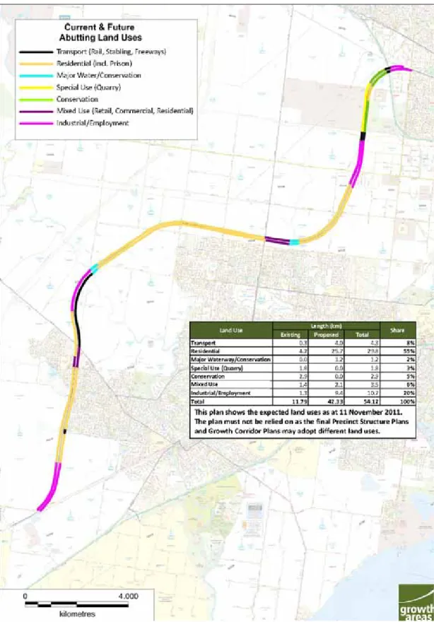
The zoning of the land within and abutting the project area is shown on Figure 1.
Figures 1A (previous page) and 1B: The project area and surrounds (Source: Provided by RRLA upon request by Committee and based on Exhibit RRL1)
The northern end of the project area lies within the Shire of Melton. Under the Melton Planning Scheme it is variously included in the Farming Zone (FZ), Business 3 Zone (B3Z), Special Use Zone (Schedules 1 and 2) (SUZ1 and SUZ2), Industrial 1 Zone (IN1Z), Public Use Zone 7 (PUZ7) and the Urban Growth Zone (UGZ). A Public Acquisition Overlay (PAO3) running east‐
west just south of Middle Road makes provision for a future freeway reservation between the Deer Park Bypass and the proposed Outer Metropolitan Ring Road.
South of Boundary Road the project area runs through the City of Wyndham.
Under the Wyndham Planning Scheme, land within and abutting the corridor is mainly zoned as UGZ. The project area skirts small areas of Public Park and Recreation Zone (PPRZ) – the Truganina Progress Association Sports Ground ‐ and Public Use Zone (PUZ5) – the Old Truganina Cemetery on Woods Road.
Derrimut Road and Ballan Road in a Road Zone 1 (RDZ1) and Tarneit Road in a Road Zone 2 (RDZ2) cross the project area.
South of Ballan Road the project area passes through the Residential 1 Zone (R1Z), with a small area of Business 1 Zone (B1Z) to the east at Wyndham Vale Square Activity Centre. South of Greens Road the project area has R1Z to the east and UGZ to the west. South of Black Forest Road it traverses UGZ until a short length of FZ at the end.
Overlays
A Development Plan Overlay (DPO) covers the Manor Lakes area on both sides of the project area from Ballan Road in the north, south to Greens Road.
It extends south of Greens Road on the eastern side of the project area with predominantly residential development at Wyndham Vale until Black Forest Road. At the southern end of the project area, an arc of PAO6 to the east provides for the future connection for electrified metropolitan passenger trains back to Werribee on the Melbourne‐Geelong rail line.
In both municipalities the project area crosses small areas of Urban Floodway Zone (UFZ) at rivers and creeks and Rural Conservation Zone (RCZ) in the immediate environs of some waterways. The Environmental Significance Overlay (Schedule 1) (ESO1) occurs at Werribee River combined with Environmental Significance Overlay (Schedule 2) (ESO2), and ESO1 applies alone at Lollypop Creek.
2.2.4 Future land use and development
The Growth Areas Authority (GAA) has responsibility for facilitating the coordination of planning and developing Melbourne’s growth areas.
Working with local Councils, developers and Government, the GAA implements urban development using corridor wide strategic land use and transport plans, and Precinct Structure Plans (PSPs) for individual suburbs of typically 10,000 to 30,000 residents.
The West Growth Corridor Plan (Exhibit GAA34 at the Committee hearing) establishes the strategic transport network, broad land use categorisation and the location of major activity centres at Tarneit, Tarneit West and Wyndham Vale. A more detailed plan of the Draft Wyndham Vale PSP Layouts (subject to change) was submitted by GAA (Exhibit GAA24(b)) which illustrated interactions between draft PSPs between the Werribee River and the Melbourne‐Geelong railway.
This more detailed plan was prepared for discussion purposes, and includes PSPs 93 (Mambourin East), 43 (Alfred Road), 42.2 South (Black Forest Road), 42.1 North (Black Forest Road), 41 (Manor Lakes) 40 (Ballan Road) and 92 (Westbrook). With the exception of PSP 43, all these PSPs directly abut the project area.
North of the Werribee River, PSPs 1091 (Riverdale), 1088 (Oakbank), 1089 (Tarneit North), 1090 (Truganina), 1087 (Derrimut Fields), and 1084 (Ravenhall (Quarry Site)) have not progressed as far as those south of the river, except for PSPs 29 (Robinsons Road Employment Area North) and 37 (Robinsons Road Employment Area South) which have been completed and approved.
GAA expects the broad land uses within the urban areas abutting the project area to comprise about 70 per cent residential, 10 per cent business and industrial, 8 per cent farming and conservation and the remaining 12 per cent other miscellaneous uses such as urban floodway (GAA24, p.4). GAA estimates that residential development will extend along the project area for around 27km, with 1500‐2000 new residences immediately abutting the project area and about 4,000 to 6,000 new residences within 100m of it. GAA explained that the 70 per cent residential land use would include not only housing but also shops, open space and other uses such as schools.
GAA provided a plan showing ‘Draft Indicative Abuttal (subject to change)’
(see page 5 of Exhibit GAA 24). An updated and more detailed plan was submitted by GAA in supplementary information (GAA 53). The updated plan is reproduced as Figure 2 below, and shows the expected land uses along the project area (as planned at 11 November 2011). Compared with the estimates in GAA 24, the residential component has reduced by about 10 per cent (55 per cent residential and 6 per cent mixed use) with a corresponding increase in the area for industrial and employment.
Figure 2: Future abutting land use types (Source: GAA based on Exhibit GAA 53).
2.2.5 Biodiversity and Aboriginal cultural impact management
While biodiversity and Aboriginal cultural impacts are matters which have separate project approval processes, the Committee was keen to ensure that any recommendations we might make concerning mitigation works would