The design approach was a rigorous multidisciplinary process with constant reflection on the purpose of the structural design and improving project outcomes. When considering the development of subdivision applications, due consideration should be given to the structural plan. The higher order road network within the development plan area shall be provided generally in accordance with the development plan.
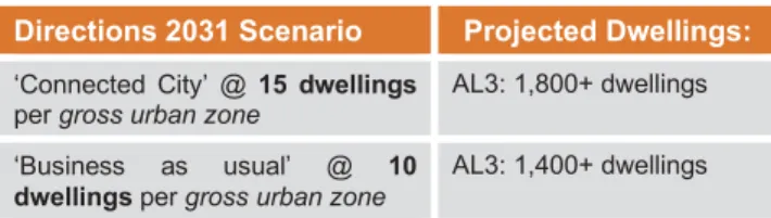
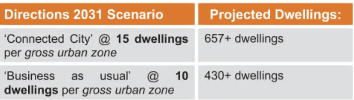
The density target for 'gross urban area' is 15 dwellings per hectare across the Structure Plan area; and. The Structure Plan defines residential boundaries that apply to specific areas within the Structure Plan. The approved Density Plan will then form part of the Structure Plan and will be used to determine future development applications.
The structure plan area will be subject to a development contribution plan (DCP) in accordance with a local planning scheme no. The structure plan area is located in the municipality of Swan and in the locality of Bennett Springs (Figure 1 refers). Whiteman Park, reserved for 'Parks and Recreation' under the Metropolitan Region Scheme (MRS), is located to the northwest of the structure plan area.
Portions of the Marshall and Coast Road reservations directly border or intersect the master plan area.
Metropolitan Region Scheme
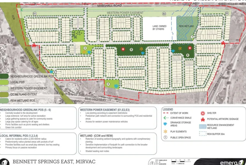
The purpose of the Bennett Springs Structure Plan Report is to provide for an orderly and proper subdivision and development of the Structure Plan area for "urban" purposes. The information in this section provides rationale and support for the comprehensive and coordinated design response provided to the Structure Plan. The structure plan area is generally bounded by Reid Highway to the south, Lord Street to the east, Marshall Road to the north and Bennett Brook to the west.
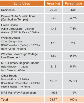
The structure plan area is located approximately 14.5 km northeast of the Perth CBD and approximately 5.5 km northwest of the Midland Strategic Metropolitan Centre. Area, land use and ownership The structural plan area comprises ~58,771 ha and has historically been used for semi-rural activities, namely cattle and sheep grazing, although there are pockets of naturally degraded vegetation and a resource enhancing wetland (REW). Houses and associated semi-rural outbuildings can be found at intervals throughout the structure plan area and a Cambodian temple (Lot 42 Coast Road) will be retained and incorporated into the future residential development.
The Structure Plan boundary covers 58,771ha, but this figure includes land reserved as 'Primary Regional Roads' and 'Railways'.
City of Swan Local Planning Scheme No.17
Directions 2031 and Beyond
Draft Outer Metropolitan Perth & Peel Sub-Regional Strategy
Perth and Peel @3.5 Million
Draft Perth and Peel Green Growth Plan For 3.5 Million
Swan Urban Growth Corridor Sub-Regional Structure Plan
Urban Housing Strategy
Urban Growth Policy The Structure Plan Area is within the West Swan growth area identified within the Policy. The strategy will inform the planning, delivery and landscape of the POS within the Structure Plan area. Most of the Structure Plan area consists of Bassendean Sands of varying thicknesses, overlying the Guildford Formations.
The majority of the structure plan area has "no known risk of acid sulfate soils (ASS) within 3 m of the natural soil surface (or deeper)". The central water feature in the structure plan area is Bennett Brook, which crosses the western boundary. Bennett Brook drains a total catchment of 69 km2, of which the structure plan area is ~2.5% of the total catchment (TME, 2011).
The Structure Plan Area includes one Resource Enhancement Wetland (REW) and an interface to a Conservation Category Wetland (CCW) according to the DEC dataset/mapping. A search of the Heritage Council database did not show any matches for European Heritage within the Structural Plan area. The building plan area is located ~520 m south of the poultry farm as its closest point.
A search in the DER's database of contaminated sites in July 2015 did not identify any contaminated sites within the Structure Plan area. It is a two-lane, undivided two-way road with a 12m carriageway close to the Structure Plan area. Lord Street, east of the Structure Plan area was previously earmarked as the southern leg of the future Perth-Darwin Highway.
Marshall Road forms the northern boundary of the Structure Plan area with existing volumes of approximately 9,900 vehicles per day (GTA, 2015). The Structure Plan area currently has access to the following bus services, all of which pass past the northern boundary of the site - Marshall Road. Whiteman Park, immediately northwest of the Structure Plan area, provides regional open space serving a regional catchment.
Located within the 'North East Sub-region', the Structure Plan area is identified as part of a wider. The Structure Plan area itself covers 58,771ha or approximately one third of the wider West-Swan-West cell.
Neighbourhood connectors
Access Streets
Also of interest is the role it will play in entering the structure plan area at both the Lord Street and Marshall Road/Dulwich Street entrances. Maintenance of the Western Power easement should be considered, recognizing that over 15 acres of land is non-deserving open space and a gateway to the structure plan area. While a general refurbishment of the easement is expected, any landscaping work and ongoing maintenance of the area will reflect the easement's land use; this is generally much lower than the designated and deserving POS areas proposed within the structure plan area (Figure 19 refers).
Development of the West Swan Urban Cell as defined in the Swan Urban Growth Corridor Sub-Regional Structure Plan (SUGCSSP) will take place in two phases; generally be. To complement the retail areas and the wider Tree Street Masterplan for the Structure Plan area, a built form, footpath and treeline strategy will guide each subdivision application. As part of the broader sustainability goals for the master plan area, it is recommended that a street tree be provided for each residential lot.
The Swan Urban Growth Corridor Sub-Regional Structure Plan (SUGCSRSP) identifies a number of proposed primary schools and one secondary school in the vicinity of the structure plan area, namely in the Dayton and Brabham Urban Cells. The nearest elementary school and likely long-term catchment area for Bennett Springs East Structure Plan residents is earmarked north of Marshall Road in the northern portion of the West Swan West Urban Cell. The master plan area does not provide any activity center or employment facilities in its boundary.
All scattered vegetation in the area of the structural plan will have to be removed prior to the start of felling operations. The structure plan area will have to undergo cut-to-fill operations to meet the all-lot requirement;. The structure plan area will be served by the existing gravity sewer located in Lombardy Crescent.
The Structure Plan area is sufficiently supplied by expanding facilities from nearby residential developments. This will be extended south west to Lord Street to serve the whole site. The structure plan area will be subject to a Development Contribution Plan (DCP) under Local Planning Schedule No.
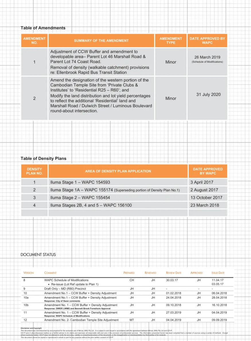
The development of the Structure Plan area will be implemented in several phases (refer Figure 21). The Structure Plan (Plan 1) referred to in the specialist consultant reports under Part 4 – Technical Studies generally corresponds to the Structure Plan (Plan 1) of the Planning Report approved by the WAPC; this.