This structure plan is prepared in accordance with the provisions of the City of Swan Local Planning Scheme No. The structure plan has been submitted to the City of Swan for consideration and approval by the Western Australian Planning Commission.
Structure Plan Map
This Structure Plan comes into force on the day it is approved by the Planning Commission of Western Australia. The building plan must be duly taken into account when considering applications for construction and subdivision.
Land Use Permissibility
The staging plan is indicative, as the timing, location and composition of the future stages will depend on market demand. A detailed program will be prepared for this as part of the ongoing detailed planning and projecting of service infrastructure.
Hazards and Separation Areas
The staging will start in the north west part of the site, with access from Chittering Road and developed for Display Village, Sales Office and 'first release'. The provision of technical infrastructure and the primary internal road network will also need to be phased at an early stage to meet development demand and/or suitable access.
Major Infrastructure
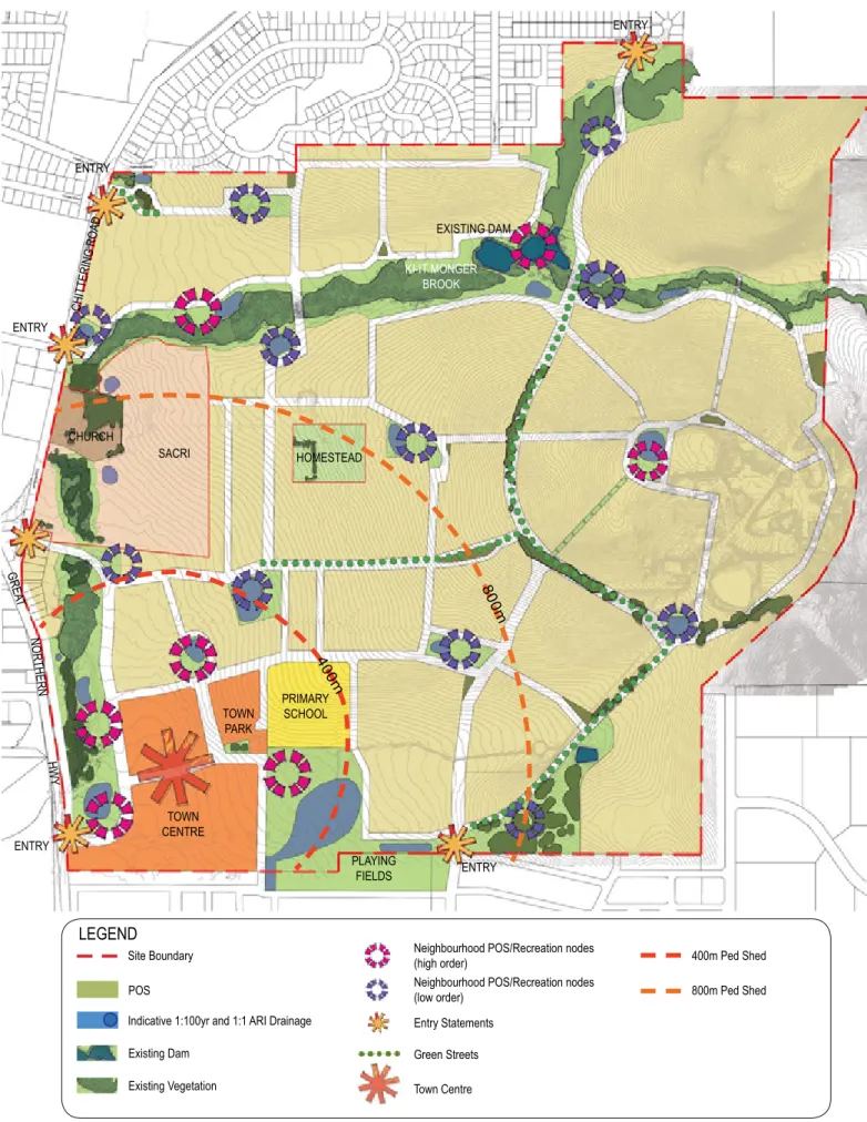
Public Open Space
Residential Density Targets
Notwithstanding the achievement of the relevant minimum and average floor area per dwelling, the criteria shall apply to: .. a) plots which are generally within, but not exclusively, within 100 meters walking distance of public open space and key distribution roads; or Notwithstanding the achievement of the relevant minimum and average floor area per dwelling, the criteria shall apply to: .. f) plots which are generally within, but not exclusively, within 100 meters walking distance of public open space and key distribution roads; .. g) plots generally within, but not exclusively, 400m walking distance of key hubs and public transport routes, schools and commercial hubs; or .. ii. designated places for a group or multi-apartment settlement.
Density Plans
R60 Located in general proximity to public open space, major distributor roads, bus routes and commercial hubs.
Prescribed Requirements
City of Swan Local Planning Policy POL-LP-11 Variation to Deemed to Comply Requirements
Notifications on Title
Development Contributions
Purpose
Land Description
Location
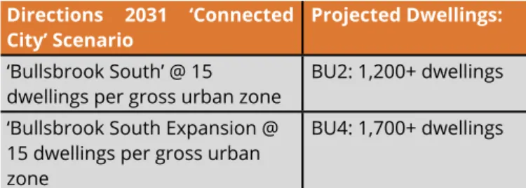
Area, Land Use and Ownership
Planning Framework
- Zoning & Reservations
- Metropolitan Region Scheme
- City of Swan Local Planning Scheme No.17
- Regional & Sub Regional Structure Plans and Strategies
- Directions 2031 and Beyond
- Draft Outer Metropolitan Perth & Peel Sub-Regional Strategy
- Draft Perth and Peel @3.5 Million
- Draft Perth and peel Green Growth Plan for 3.5 Million
- Significant Planning Strategies
- City of Swan Urban Housing Strategy
- City of Swan Bullsbrook Townsite Landuse Masterplan
- Relevant Local Government Planning Policies & Strategies
- Relevant State Planning Policies
- State Planning Policy 2.4 – Basic Raw Materials
Located within the 'North-East Sub-Region', the Structure Plan area is identified as an 'underdeveloped urban outpost'. The Structure Plan Area is identified as a mix of "Urban Push" and "Urban Expansion" under the draft North-Eastern Sub-Regional Planning Framework (Figure 5 refers). The Greenfields Strategy identifies the Structure Plan area as a mix of "Undeveloped Urban Backyard Area" and "Urban Expansion Area".
Biodiversity and Natural Area Assets
- Vegetation
- Regional Vegetation
- Threatened Ecological Communities
- Remnant Vegetation
- Flora
- Bush Forever
- Fauna
The Structure Plan Area is in close proximity on its northern site boundary (within Lot 857) to Bush Forever Site No. Potential habitat remaining within the structure plan area includes intermittent remnants of natural vegetation along Ki-it Monger Brook. As a result, the majority of the limited existing habitat within the structure plan area will be retained through the retention of vegetation in Ki-it Monger Brook.
Landform and Soils
Topography
Based on historical land use, mapped vegetation units and condition, this species is considered likely to occur within the Bush Forever No.86 area, but not within the Structure Plan area. Potential habitat within the Structure Plan area for the black cockatoo species consists of Eucalyptus rudis trees of poor food quality within the stream line and occasional mari trees. Fauna habitat outside the Structure Plan area (Bush Forever Site No. 86) includes more intact vegetation structure and potentially provides fauna habitat for Carnaby's Black-Cockatoo (Calyptorhynchus latirostris) and Baudin's Black Cockatoo (Calyptorynchus baudinii).
Regional Geomorphology
The Structure Plan area exhibits a high level of disturbance due to historical clearing of native vegetation and consists mostly of cleared agricultural camps. The proposed management and use of the Ki-it Monger Creek and on-site water features (dams) will replicate pre-development conditions related to both surface and groundwater availability to the existing vegetation. These trees will be preserved in the Ki-it Monger Brook and the location of the road stream crossings will be chosen to minimize the impact on the existing mature trees.
Acid Sulphate Soils
A literature review identified an endangered flora taxon, Acacia anomala, previously recorded in Bush Forever No. The Bush Forever site is around 43 ha of bushland associated with regionally significant vegetation and fauna habitat, including black cockatoo foraging and roosting. The stream line also allows for the movement of natural fauna from the western part of the site to areas with greater residual vegetation to the east.
Groundwater and Surface Water
- Groundwater
- Regional Groundwater Levels
- Site Groundwater Levels
- Groundwater Quality
- Surface Water
- Wetlands and Waterways
- Monitoring
Due to the significant depth of groundwater over most of the site, continuation of a pre-development groundwater monitoring program is not considered necessary. A pre-development surface water monitoring program has commenced and will continue through to the Urban Water Management Plan (UWMP) stage of the development. It is proposed that the post-development surface water quality monitoring program will involve biannual sampling of the main dam as well as opportunistic sampling (if the creek is flowing) from the Ki-it Monger Creek upstream of the main dam and downstream of the dam upstream of the Ki -it Monger creek leaves the site.
Heritage
Bushfire
Context and Other Land Use Constraints and Opportunities
Noise
- Nursery
- Great Northern Highway & Chittering Road
Potential Contamination
Landfill Site
Existing Movement Networks
Great Northern Highway
Chittering Road
Existing Pedestrian and Cyclist Networks
Existing Public Transport
Land Use
- Education
- District and Regional Open Space
- Activity Centres and Employment
- Community Facilities
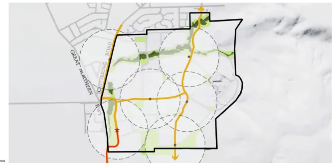
The locality of Bullsbrook is currently well maintained with community facilities including community halls, a library, sports club, childcare, youth facilities, skate park, BMX track, hard courts, tennis courts, riding trails and a golf club near the Structure Plan area. Additional community amenities will be needed as the population of the Town of Bullsbrook grows and will be included in the development contribution plans for the area. Some future community facilities can be accommodated in the future Neighborhood Center in the Structural Plan Area.
External Design Influences
Acoustics & Noise Targets
- Pearce RAAF Base
- Great Northern Highway
- Chittering Road
Bush Fire Management
Design Philosophy
Opportunities and Constraints
Landform
A significant portion of the area can be categorized as moderately steep to slopes of 5% or more. As only a small proportion of the site has slopes greater than 10%, development on steeper land will need to be designed and provided sensitively. These aspects are taken into consideration where possible as part of the structure plan design.
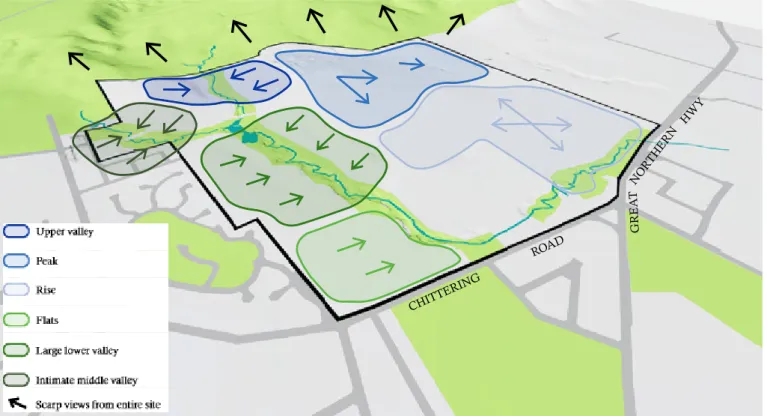
Views and Landscape
The landform of the area and its surroundings is unique and consists of a series of valleys and hilltops, peaking at a high point of RL 114m to the east and falling to a low point of RL 46m to the southwest. On steeper areas in general, there will be a need for a combination of civil, landscape and built-up solutions to take character and functional considerations into account.
Place Vision
Place Design Principles
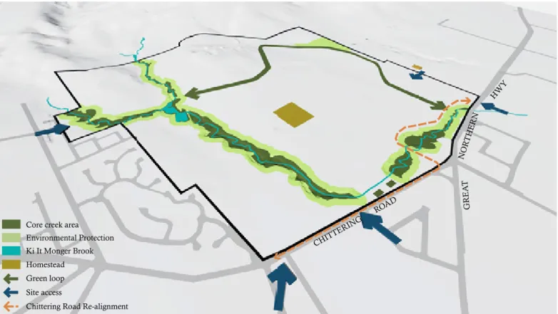
- Immersed in the Landscape
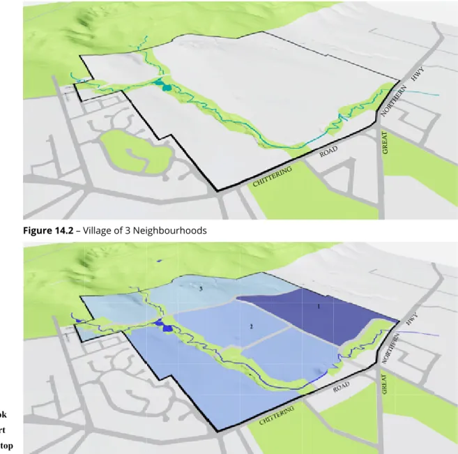
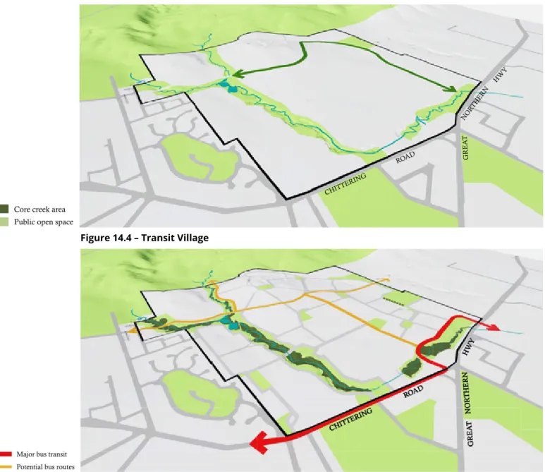
- Village of 3 Neighbourhoods
- Brook
- Heart
- Hill-top
- Connected by Nature
- Transit Village
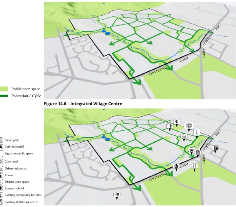
- Integrated Village Centre Heart
- Connected Open Space Network
A bus station terminal is proposed to be located adjacent to the village center in accordance with the Land Use Master Plan. Very identifiable within the landscape will be the open public space to the southeast, formed around a large layer of trees held in a pit. It is effectively a focal point for lining a series of roads that provide visual and physical links to other open spaces, including other high points, existing Bullsbrook community facilities and the Village Centre.
Variations from the BTLUMP
District Open Space
Rapid Transit Activity Corridor and Chittering Road
In accordance with the BTLUMP, a primary school is proposed within the southern part of the Structure Plan Area. Located within the 'North East Sub-region', the Structure Plan area encompasses the entirety of the land identified as 'urban deferred zoned undeveloped' known as BU2 'Bullsbrook South' and is also part of a wider 'urban extension area known as 'BU4 Bullsbrook South Extension'. A description of each of the proposed internal roads included in the Structure Plan area is provided herein.
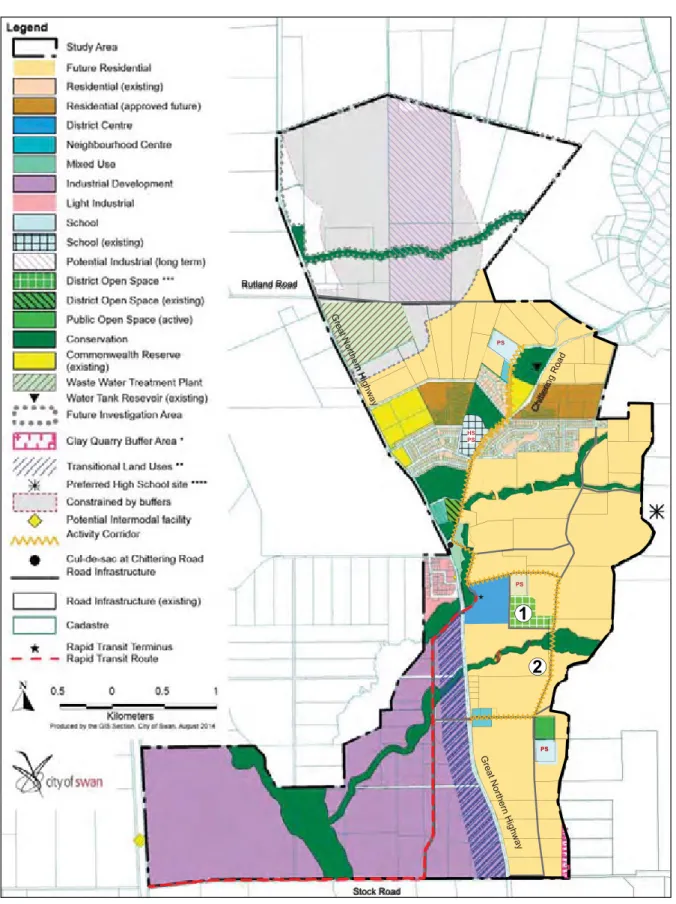
Primary School
Land Composition
The land use composition provides a range of residential densities amongst a diverse amenity mix, including Ki-It Monger Brook and the existing CCW, DAC and future primary school site, as well as District Open Space. The purpose of the land use mix is to facilitate a diverse and interactive community that supports high levels of amenity and allows a vibrant and robust economy to develop truly reflecting the status of the district.
Primary School Site
Dwelling Forecasts
Projected Dwellings
Directions 2031 Forecasts
Liveable Neighbourhoods Forecasts
Residential Density Coding
- Residential R5 - R20 Precinct
- Residential R10 – R30 Precinct
- Residential R20 – R50 Precinct
- Residential R50 - 60 Precinct
Located near the District Center (services and facilities), primary school, nature facilities, future public transport and on flatter grounds. A number of terrace typologies on small lots are envisaged in the immediate vicinity of the district centre. Frontage to two intersecting roads will impose higher density development generally located on the 'book ends' of residential cells.
Local Development Plans
Prescribed Requirements
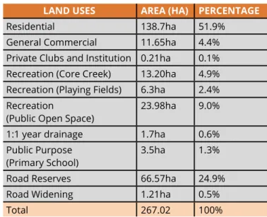
The road hierarchy focuses on the provision of two key north-south roads through the west and east of the Structure Plan area. Situated north-west of the Structure Plan area on Chittering Road is Bullsbrook College, a Nursery – Year 12 state school. A service report (Appendix 11 refers) has been prepared in support of the Structure Plan and is summarized herein.
Other Built Form and Streetscape Provisions
District Activity Centre
Overview
Vision
The District Activity Center strives to represent closeness to the local community, with its focus on the "edge of town", and has elements of a relaxed (medium-sized) country high street. This suggests smaller-scale buildings around (only a few) streets of varying widths, hierarchy and character, with a built form that allows for a certain eclecticism and artistry, as if the (traditional or familiar idea of a) rural town had undergone these changes from its original state, due to the attraction of the semi-rural lifestyle being rediscovered/reinvented by former inner-city or suburban dwellers.
Built Form
- Guiding Principles
- Urban Elements
- Design Principles
- Landscape Principles
- Design Intent
- Objectives
- Materials & Colour
- Design Intent
- Objectives
The building typology can afford to be mixed, with both parapet and exposed roof forms, with a scale suitable for a wider street, but not always 'two storeys'. To develop a built form character specific to the Bullsbrook Center through a consistent palette of materials and colors that allows for variety and innovative architectural responses.
Movement Networks
- Primary External Road Network
- Site Access
- Proposed Internal Road Network Configuration and Hierarchy
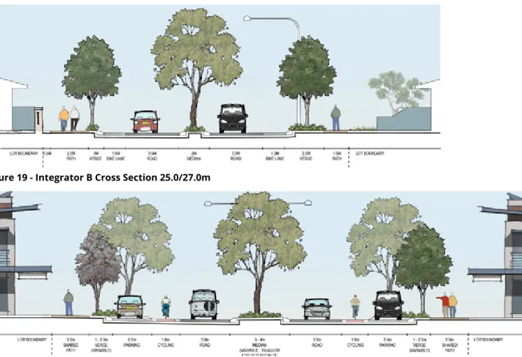
- Integrator B
- Neighbourhood Connectors
- Neighbourhood Connector A
- Neighbhourhood Connector B
- Access Streets
- Public Transport
- Pedestrian and Cycle Infrastructure
- Integration with the Surrounding Area
A mixture of neighborhood link A and B roads is proposed throughout the structure plan area and primarily facilitates central east-west connections. Neighborhood Connector A also includes a 4.1m curb (which can be reduced if parking is incorporated) and a 2.0m median. The structure plan design allows for bus connections on all of the proposed Neighborhood Connector and Integrator B roads, which is a suitable standard to accommodate bus services.
Public Open Space
- Local Amenity
- Linear Open Space Network
- Living Streams
- Ki-it Monger Brook
- District Open Space (Playing Fields)
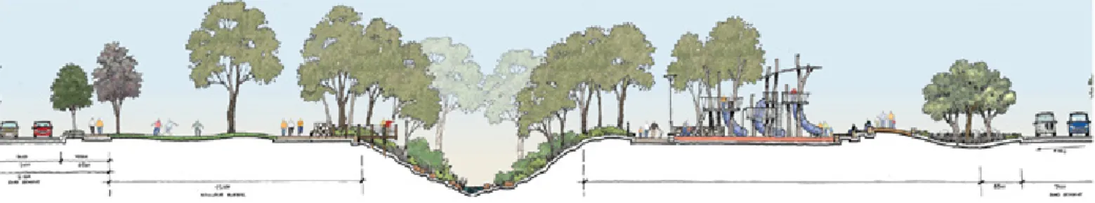
SUBJECT LAND EXISTING PLOT BORDER URBAN RECREATION RECREATION (CORE CREEK AREA) RECREATION (PLAYING FIELD) WATER RECREATION (REFERENCE NO.) Figure 21 - Public space. LIMITED USE PUBLIC SPACE TERRAIN Drainage filtration area between 1:1 and 1:5 years. is part of neighborhood and neighborhood parks) 0.78 ha. It is proposed to house part of the Neighborhood Open Space on the adjacent landholding to the south.
Street Trees and Retention
Urban Water Management
Planning will be zoned according to irrigation requirements, with full irrigation according to requirements for the informal playing field area. Design plans to be zoned according to irrigation requirements, with full irrigation according to requirements for formal field sports grounds. Planning design to be zoned according to irrigation requirements, with full irrigation according to requirements to informal playing areas on the ground.
Education Facilities
WC had completed the planning study for the provision of additional water services to the Bullsbrook area. WC advised that the supply to the structure plan area would be via a new DN200 distribution line between Hurd Road and Parkland Parade installed to the west of the site along Chittering Road. Additional infrastructure may be required to provide the necessary power to the rest of the site.
Infrastructure Coordination, Servicing and Staging
Ground Conditions
Sewage
Water Supply
Power Supply
Telecommunications
Gas
Roads
The Structure Plan (Plan 1) referred to in the specialist consultants' reports under Part 4 – Technical Studies generally corresponds to the Structure Plan (Plan 1) of the Planning Report approved by the WAPC; knowing that consultant reports were generally prepared to guide the final Bullsbrook Central Structure Plan Planning report and Plan 1 within. Where minor differences are identified in Plan 1 between the Planning Report and the Consultant's Reports under Part 4 – Technical Studies, the Planning Report (Plan 1) shall prevail.
Stormwater Management & Drainage
Development Contributions Arrangements
Other Requirements
Staging