1 TO ROSEHILL WATERS STRUCTURE PLAN APPROVED BY RESOLUTION OF THE WESTERN AUSTRALIA PLANNING COMMISSION DATED: 4 JULY 2022. The Rosehill Waters Structure Plan (the Structure Plan) relates to the former Rosehill Golf Course and Country Club located at South Guildford in the City from Swan.

Structure Plan Area
Structure Plan Objectives
Structure Plan Content
Operation
Staging
Subdivision and Development Requirements
- Land Use and Development
- Precinct Requirements
- Residential Density
- Public Open Space
- Local Development Plans
- Additional Information
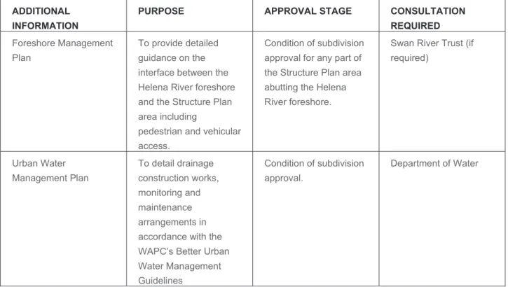
PA-951 ROSEHILL WATERS STRUCTURE PLAN_V2 ENVIRONMENTAL ASSESSMENT REPORT 15th Town of Swan for approval for all land directly adjacent to an existing residential development. A condition of subdivision approval for any part of the buildable plan area adjacent to the foreshore of the Helena River.
Introduction and Purpose
Land Description
- Regional Context
- Local Context
- Population & Demographics
- Site Details
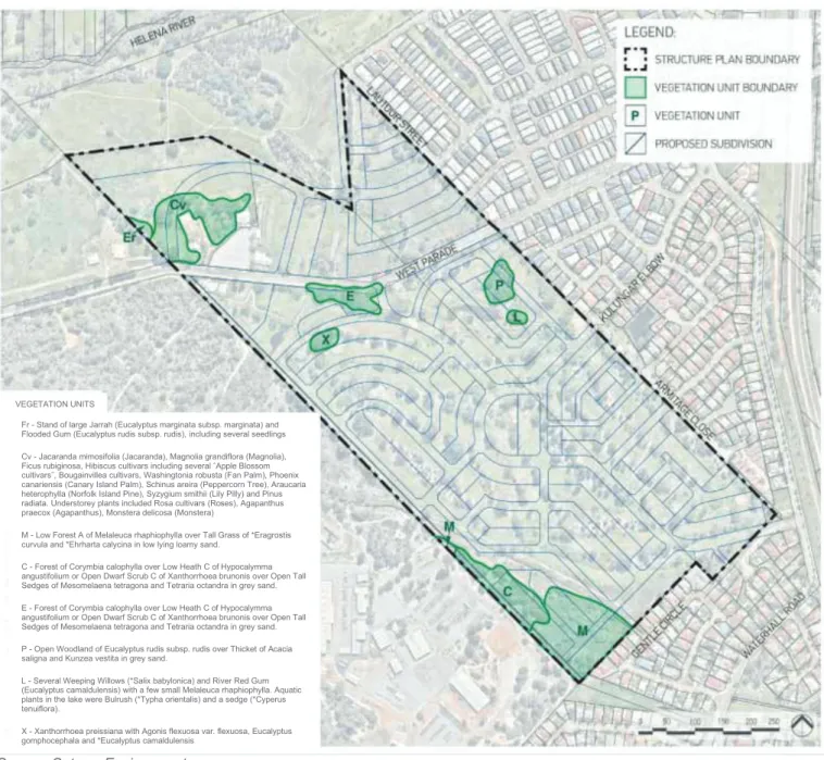
The site is mostly vacant land with most of the land previously occupied by a private golf course. There is little vegetation remaining within the site, with most trees having been planted as part of previous land use activity.

Planning Framework
Zonings & Reserves
- Metropolitan Region Scheme
- City of Swan Local Planning Scheme No. 17 (LPS17)
Planning Strategies & Policies
- State Planning Strategy
- North-East Sub-Regional Planning Framework
- State Planning Policy No.3: Urban Growth and Settlement
- State Planning Policy No.5.1 – Land Use Planning in the Vicinity of the
- State Planning Policy No.3.7 – Planning in Bushfire Prone Areas
- City of Swan Urban Housing Strategy
- Other Policies and Guidelines
The North East Sub-Regional Planning Framework forms part of the Perth and [email protected] Million strategic series of planning documents. State Planning Policy No.5.1 – Land Use Planning in the Precinct of Perth Airport of Perth Airport.
Other Approvals and Decisions
- Metropolitan Region Scheme Amendment No.1266/57
- Local Planning Scheme No.17 – Amendment No.194
This section of the Structure Plan has been directly informed by the Local Water Management Strategy (LWMS) prepared by Coterra (refer Appendix B). Due to the existing topography of the Structure Plan, significant earthworks will be required to prepare the site for residential development.
Site Conditions & Contraints
Biodiversity and Natural Area Assets
- Flora & Vegetation
- Fauna
- Waterways
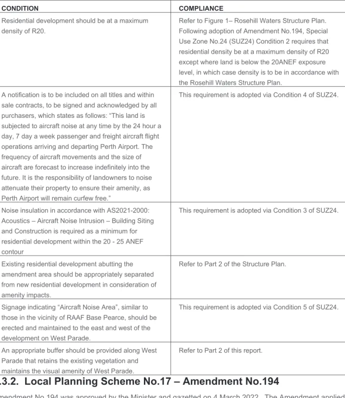
There are no Bush Forever sites located within the Structure Plan, but there is Bush Forever site No.311 located directly adjacent to the west of the Structure Plan (refer Figure 8). A second ecological linkage was identified as marginally intersecting the northernmost portion of the Structure Plan. Original vegetation complexes found across the site include the Swan Complex (towards the northern part of the site), the Guildford Complex (towards the north-west corner) and the Southern River Complex towards the rest of the site.
The two tributaries of the Helena River that flow through the area form key environmental features of the structural plan.
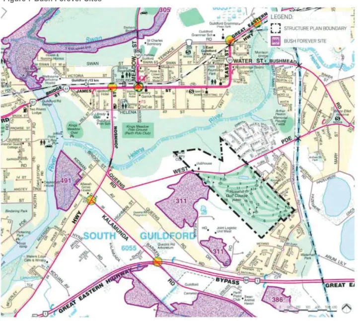
Landform & Soils
- Topography
- Soils & Geology
- Acid Sulfate Soils
The depth of sand above the clay layer is less along the two tributaries and closer to the Helena River. Most of the area has been designated by the Department of Environmental Regulation (DER) as a Moderate to low risk that acid sulfate soils occur within 3 meters of the soil surface.
It has been identified that a small area in the southern part of the area has been designated with a low to zero risk.
Groundwater and Surface Water
- Groundwater
- Surface Water
- Floodways & Floodplains
- Wetlands
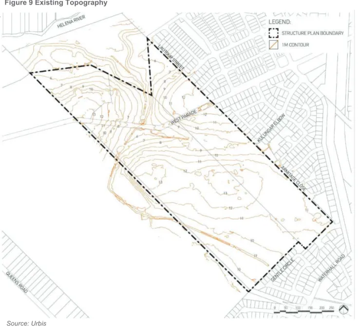
Floodways and floodplains have been defined by the Department of Water and their implications for the site are shown in Figure 10. The northern part of the site along the drainage channel downstream of West Parade is slightly affected by the 100 year ARI flood margin. Much of the area is shown as a Multiple Use Wetland (MUW) in DEC's Swan Coastal Plain Geomorphic Wetlands dataset.
The 1992 (Swan Coastal Lowland Lakes) Environmental Policy (EPP) map does not show any wetlands located within or immediately adjacent to the site.
Bushfire Hazard
Aboriginal Heritage
Amergin Consulting conducted an ethnographic and archaeological field survey (see Appendix H) to assist in the preparation of the structural plan and to assist in determining the most appropriate planning response for future subdivision and development within the existing cultural value. During the consultation, concerns were raised about the diversion of the watercourse/drainage with the advantage of returning the drainage to its former, natural course. Redevelopment of the drain along with its conversion into a 'living stream' with associated public open space and native planting was a popular option.
However, the Department of Aboriginal Affairs (DAA) has confirmed that the part of the altered stream that extends into the structure plan is outside the area reported to have heritage values.
European Heritage
Key findings from the ethnographic study highlighted the importance of the Helena River, including human movement, camping, ritual uses, hunting, fishing, bush gathering and medicine. Similarly, the significance associated with the altered watercourse/drainage extending into the area and forming part of the registered area was highlighted. This will result in an integrated water management system that is sensitive to existing cultural values and aligned with the principles of Water Sensitive Urban Design (WSUD).
Other Land Use Conditions and Constraints
- Existing Road Network
- Contaminated Sites
- Aircraft Noise
- Infrastructure & Utilities
Design Philiosphy, Land Use & Subdivision/Development
Design Vision
Sustainable Responsive Design
Community Consultation
Design features within each home to assist in achieving optimal energy efficiency and installing smart meters. Installation of sufficient solar photovoltaic (PV) generation to cover the typical annual energy consumption of a single residence. 50 percent reduction of potable water through efficient hydraulic fittings and options for rainwater tanks.
Conservation and restoration of existing improvements to the site including the Rosehill Lodge, Padbury Stables and existing gardens.

Land Use
- Residential
- Private Clubs and Institutions
Local Reserves
- Public Purposes
- Public Open Space
Open Space
- Open Space Distribution and Calculation
- Tree Protection Zone
- Public Open Space (POS) Form & Function
The park is located along the central spine of the estate and offers beautiful views that can extend to the Helena River. Nullagine Park follows the living stream located southwest of the structural plan to create a passive space for informal gatherings. The extent of the upgrade will be assessed in collaboration with the City of Swan and.
Kulungar Park is not part of any credited open space as it falls outside the Structure Plan.

Landscape Design
- Irrigation Strategy
- Landscape Management
A cross-section of this POS has not been provided as it is outside the structural plan and will be subject to further consideration and detailed design. Lot 1 is owned by the water company and as such the overall management of this corridor will remain the responsibility of the authority. The POS areas will blend seamlessly with the lot and the streetscape interface will vary from level to landscape integration.
Civic and Community Facilities
Potential for civic and community facilities within the existing improvements and within the remaining area set aside for 'Private clubs and institutions'. Space has been made available for community festivals, events and community gardens, encouraging interaction and community life.
Future MRS Amendment
Future Village Centre
According to the submitted structure plan, the rear components of the shopping center will be covered by rear-loaded residential development (lots are located within the 20-25 ANEF contours).
Management of Interfaces
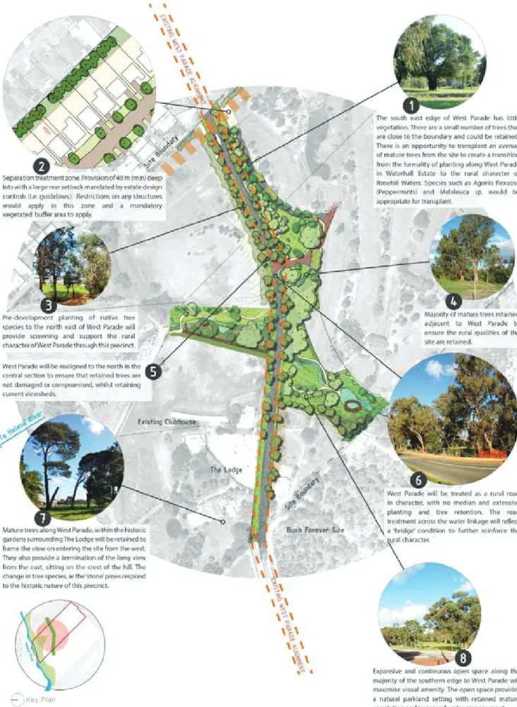
Deeper plots (i.e. 40 meter deep plots) will be provided to those plots immediately adjacent to existing residential development (refer Figure 20). These setback areas will be planted out (by the proponent) as part of the build-out, with the exact type and nature of planting to be determined through consultation with the community. The exact nature of these treatments will be determined in consultation with the City of Swan and the local community.
The above together with the details in Figure 20 show how the conditions of MRS 1266/57 have been considered in the preparation of the structural plan and how they will be delivered at the detailed design stage.
Movement
- Existing Access & Movement
- Movement Network Hierarchy
- Street Types
- Upgrades to Great Eastern Highway/Queens Road Intersection
- Pedestrian and Cycle Network
- Public Transport
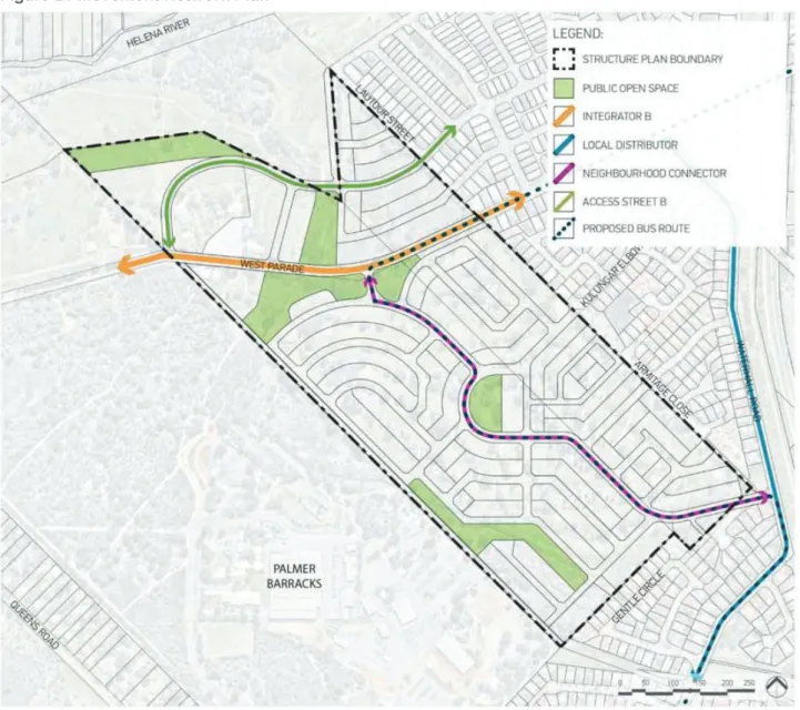
The embankment – The road connection from the structure plan to the embankment to the northeast corner of the site is located outside the structure plan boundary and located within land reserved for. The pedestrian and cyclist network will provide a high level of accessibility and connectivity for pedestrians and cyclists within the Structure Plan to the surrounding neighbourhoods. The hierarchy for pedestrian and cyclist facilities within the Structure Plan corresponds to Livable Neighborhoods and is demonstrated in Figure 24.
The nearest bus stop from the Structure Plan is approximately 400 meters away which is a comfortable 5 minute walking distance.
Water Management
- Water Conservation
- Stormwater Management
- Living Streams
- Groundwater Management
- Flood Management
Stormwater from this area will be infiltrated into this section of the site via underground infiltration cells. The live streams will be designed to transport runoff from the proposed urban areas as well as runoff from upstream catchments. Due to the change in land use, a significant improvement in the quality of ground water will be experienced.
The City of Swan will be required to refer the application to the Department of Water for their advice on finished floor levels.
Bushfire Management
In accordance with the City of Swan LPS17, development within a flood prone area will be required to obtain planning approval.
Noise Management
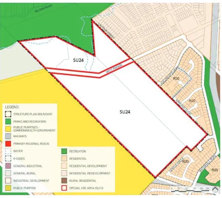
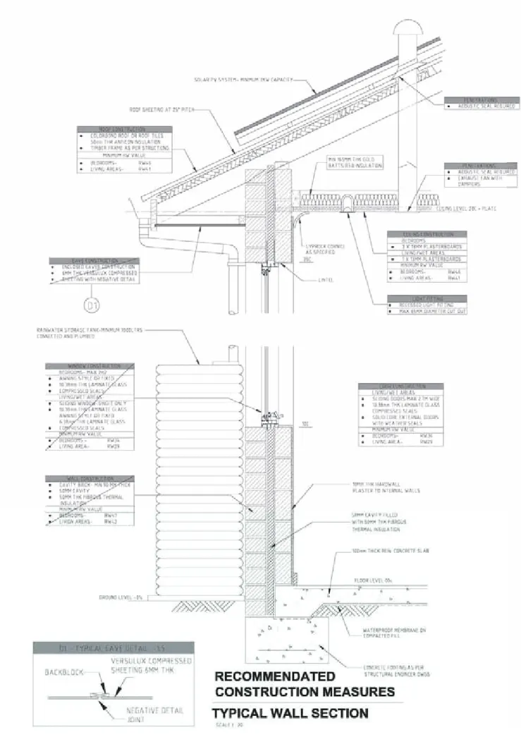
Residential development will not encroach within the 25+ ANEF outline as set out under the conditions of the proposed "Special Use" zone. Within the area unaffected by aircraft noise, limited density development to R30 in two locations is permitted under the Structure Plan (Figure 1). All residential development within the Structural Plan area will include noise insulation in accordance with AS2021-2015.
Various noise mitigation methods will be incorporated into the built form in relation to finishes and materials for roofs and ceilings, walls, windows and doors (refer to Figure 26).
Servicing & Infrastructure
- Power
- Sewer
- Water
- Gas
- Telecommunications
- Earthworks
Specific easements may be required which will be considered in the detailed planning phase. The site will be dug with the intention of minimizing input fill requirements with the aim of achieving a cut-to-fill balance across the site, in line with the EnviroDevelopment strategy. Small areas will need to be cleared to remove existing trees where they could not be preserved in public open space or reserves and have been identified as having a low retention value.
Construction of retaining walls will be required to ensure level building sites, with specific planning and engineering techniques implemented to minimize walls of significant height.
Built Form Delivery
The construction management plan, which is required as part of the subsequent detailed design phase, will outline the proponent's intent and scope for organizing waste collection during the various construction phases. Due to the density limitation within the building plan, the possibility of ensuring diversity in the built form is limited. Regardless, it is recognized that Rosehill Waters will encompass a wide demographic, with a mix of households requiring equally diverse housing choices.
Design guidelines will be prepared and managed by the proponent which will help achieve the objectives of the built form.