i
ESTIMATION OF BIOMASS AND LITTER LEAVES
PRODUCTIVITY OF MANGROVE FOR MANAGEMENT IN
ENGGANO ISLAND, BENGKULU, SUMATRA, INDONESIA
MOHAMMED SADEQ MOHAMMED AWN
GRADUATE SCHOOL
BOGOR AGRICULTURAL UNIVERSITY
BOGOR
DECLARATION OF ORIGINALITY
I hereby declare that this thesis titled “Estimation of Biomass and Litter Leaves Productivity of Mangrove for Management in Enggano Island, Bengkulu, Sumatra, Indonesia” and the work reported herein were composed by and originated entirely from me under the supervision of my supervisory committee. I therefore declare that; this is a true copy of my thesis as approved by my supervisory committee and has not been submitted for a higher degree to any other University or Institution. Information derived from the published and unpublished work of others has been duly acknowledged in the text as well as references given in the list of sources.
Bogor, March 2017
Mohammed Sadeq Mohammed Awn
ii
RINGKASAN
MOHAMMED SADEQ MOHAMMED AWN. Estimasi Biomassa dan Produktivitas Seresah Daun Mangrove untuk Pengelolaan di Pulau Enggano, Bengkulu, Sumatera, Indonesia. Dibimbing oleh FREDINAN YULIANDA dan YONVITNER.
Estimasi terhadap biomassa dan produktivitas seresah daun di hutan mangrove memegang peranan sangat penting dalam siklus nutrisi dan potensinya dalam menyerap karbon. Produktivitas mangrove sering ditentukan dengan rata-rata seresah daun. Oleh karena itu, tujuan dari penelitian ini adalah untuk mengidentifikasi spesies, menganalisa karakteristik dan memperkirakan biomassa mangrove dan produktivitas seresah daun mangrove di Pulau Enggano. Pengambilan data mangrove menggunakan metode transek kuadrat (10 m x 10 m) secara acak dengan tujuh stasiun, dianalisa tegak lurus terhadap garis pantai. Enam belas perangkap seresah daun dipasang di bawah pohon mangrove untuk mengumpulkan seresah dari pohon-pohon dengan mengukur ukuran diameter dengan tinggi dada (DBH) dan diameter lebih besar dari 4cm, hasil seresah daun dibawa, diukur berat kering di laboratorium. Kepadatan relative mangrove jenis
Rhizophora apiculata, Bruguiera gymnorrhiza, Sonneratia alba, dan Xylocarpus granatum, masing-masing adalah 63%, 27%, 6% dan 5%. Rhizophora apiculata
memiliki nilai tertinggi dan Xylocarpus granatum yang terendah. terdapat hubungan linier antara biomassa dan tutupan batang mangrove dengan hasil korelasi R2 = 0.95. Estimasi tutupan batang mangrove dan biomassa Bruguiera gymnorrhiza memiliki nilai tertinggi adalah 95 m2/ha dan 139 ton/ha, sedangkan yang terkecil adalah Xylocarpus granatum 13 m2/ha dan 21 ton/ha terendah. Rata-rata diameter dan produktivitas masing-masing empat spesies adalah: Rhizophora apiculata 28.8 cm, 2,6 g DW m-2 hari-1, Bruguiera gymnorrhiza 57 cm, 2,9 g DW m-2 hari-1, Sonneratia alba 23.7 cm, 2,5 g DW m-2 hari-1, dan Xylocarpus granatum
38,3 cm, 2,7 g DW m-2 hari-1.
Peningkatan diameter tertinggi pohon mangrove memberi pengaruh peningkatan produktivitas seresah daun pada setiap individu, spesies Bruguiera gymnorrhiza menunjukkan produktifitas yang lebih tinggi dibandingkan dengan spesies lain. Produktivitas berat kering serasah daun dihubungkan dengan diameter batang (DBH) menunjukkan koefisien korelasi yang signifikan dan koefisien korelasi dari semua spesies individu. Spesies Sonneratia alba adalah yang ber-korelasi tertinggi dan yang paling rendah ber-korelasinya adalah spesies Xylocarpus granatum. Dari temuan itu, digambarkan bahwa ada dampak tak langsung dari perubahan karakteristik hutan mangrove ditambah dengan perambahan manusia yang menurunkan populasi Xylocarpus granatum dan Sonneratia alba, serta rendahnya kepadatan semai dan anakan karena berkurangnya ukuran sedimen di kawasan mangrove karena reklamasi lahan di pulau dan aktivitas pembangunan. Karena itu diperlukan mitigasi lingkungan untuk melestarikan ekosistem. ini adalah penelitian yang pertama memberikan informasi tentang biomassa dan produktivitas daun sampah bakau di Pulau Enggano.
SUMMARY
MOHAMMED SADEQ MOHAMMED AWN. Estimation of Biomass and Litter Leaves Productivity of Mangrove for Management in Enggano Island, Bengkulu, Sumatra, Indonesia. Supervised by FREDINAN YULIANDA and YONVITNER.
Estimation of mangrove biomass and productivity litter leaves is an important issue because it plays a vital role relevant to nutrient turnover and potential carbon sink. Mangrove productivity is often determined by average litter leaves. Therefore, the aim of this study was to identify species, characterization and estimation of aboveground biomass and productivity litter leaves of mangrove vegetation in Enggano Island, Sumatra, Indonesia. The data was collected randomly at 10 m x10 m by quadrat transect sampling points along with seven stations laid perpendicular to the shoreline. Sixteen litter traps were installed under the mangrove trees individual to collect leave litter by recording the size diameter at breast height (DBH) at random locations and was taken for dry weight in laboratory. The relative density of species that were founded were Rhizophora apiculata,
Bruguiera gymnorrhiza, Sonneratia alba, and Xylocarpus granatum, 63%, 27%, 6% and 5% respectively. Rhizophora apiculata showed the maximum values and
Xylocarpus granatum showed the lowest. There was strong a correlation between aboveground biomass and the stand basal area in mangrove which is explained by R2 = 0.955. Estimation for the stand BA and biomass, Bruguiera gymnorrhiza
present the highest quantity at 95 m2/ha, 139 ton/ha and Xylocarpus granatum
showed the minimum values for stand BA and biomass 13 m2/ha, 21 ton/ha respectively. The average DBH and productivity of dry weight litter leaves individual for each specie, Rhizophora apiculata 28.75 cm and 2.6 g DW m-2 day -1, Bruguiera gymnorrhiza 57 cm and 2.9 g DW m-2 day-1, Sonneratia alba 23.75 cm and 2.5 g DW m-2 day-1, Xylocarpus granatum 38.3 cm and 2.7 g DW m-2 day -1 respectively,
The analysis showed that increased the DBH of mangrove trees cause increased in productivity of litter leaves in relation to significant correlation coefficient. Bruguiera gymnorrhiza showed the highest productivity of dry weight litter leaves as compared to the other species. The specie Sonneratia alba had the highest value for correlation and the lowest correlation was shown by Xylocarpus granatum. The findings illustrate there was indirect impact of change in character of mangrove trees due to human encroachment evidence by the reduction in
Xylocarpus granatum and Sonneratia alba species population, as well the decrease in density of both the seedlings and sapling because of the high sedimentation in the mangrove areas due to land reclamation and acts of development. Therefore urgent need for environmental mitigations to preserve the ecosystem. This is the first result of research that could provide information about biomass and productivity of mangrove litter leaves on Enggano Island.
iv
© Copyright, owned by IPB, 2017
All rights reserved
No part of this document may be reproduced or transmitted in any form or by any means, electronic, mechanical, photocopying, recording, or otherwise, without prior written permission from Bogor Agricultural University (IPB)
1 A Thesis
Submitted in partial fulfillment of the requirements for the degree of Master of Science
In
Coastal and Marine Resources Management
ESTIMATION OF BIOMASS AND LITTER LEAVES
PRODUCTIVITY OF MANGROVE FOR MANAGEMENT IN
ENGGANO ISLAND, BENGKULU, SUMATRA, INDONESIA
GRADUATE SCHOOL
BOGOR AGRICULTURAL UNIVERSITY
BOGOR
2017
2
4
ACKNOWLEDGEMENT
First and foremost I praise and acknowledge Allah, the most beneficent and the most merciful. Secondly, my humblest gratitude to the Holy Prophet Muhammad (Peace be upon him) whose way of life has been a continuous guidance for me. I would like to express my deepest gratitude to my advisors, Dr Ir Fredinan Yulianda and Dr Yonvitner as well as Dr Ir Achmad Fahrudin as an external examiner whose invaluable supervisions, guidance, support, enthusiasm and more importantly, constructive criticisms have perfected and providing me with an excellent ambience for doing research.
I also wish to acknowledge the Government of Indonesia through the Ministry of Education and Culture (DIKTI) and KNB for the grant of scholarship to pursue my master’s degree. I also wish to thank the all staff Program study Coastal and Marine Resources Management, Department of Living Aquatic Resources Management, Faculty of Fisheries and Marine Science, Bogor Agricultural University (IPB) are much appreciated.
I further wish to thank all colleagues in the Bogor Agricultural University (IPB), staff and colleagues in the university of Bengkulu, who gave their contributions and help in diverse ways.
Furthermore, I would like to express my profound love and special thanks to my loving parents; Mr. Sadeq Mohammed Awn and Mrs. Ulouf Taha for their constant pieces of advice, guidance and prayers. Supports and persistent encouragements from my siblings, especially to my brothers Mr. Mr. Belal Sadeq and Mr Basam Sadeq and all friends during this study are as well deeply appreciated.
Finally, I appreciate each and every person that directly and/or indirectly contributed to the completion of this work piece. Indeed, you all have played significant roles to this work and may Allah shower his bless upon all of you.
Bogor, March 2017
TABLE OF CONTENTS
Estimation Aboveground Biomass and Stand Basal Area of Mangrove Species 20
Correlation between Stand Basal Area and Aboveground Biomass of Mangrove 22
Estimation Productivity Litter Leaves of Mangrove in Enggano Island 23
Correlation between Productivity Litter Leaves and Diameter Breast Height of Mangrove in Enggano Island 25
4 CONCLUSION AND RECOMMENDATION 27
Conclusion 27
Recommendation 28
APPENDIX 35
BIOGRAPHY 30
LIST OF TABLES
1 Important value index of Mangrove species for all station in Enggano Island 132 Coverage area of classified Mangrove density year 2015 in Enggano Island 17
3 Estimation Aboveground Biomass (AGB, ton/ha) stand Basal Area (Stand BA m2/ha) of Mangrove for all station in Enggano Island 22
14 Average productivity litter leaves individual of Mangrove in Enggano Island 24
15 Correlation between Productivity litter leaves and DBH of Mangrove species individuals in Enggano Island 26
6 Average productivity litter leaves individual of mangrove and diameter breast height 37
7 Average of Stand BA, ABG of mangrove species for all station in Enggano Island 37
8 Location Coordinates of Research 38
9 Environmental parameters 38
1 INTRODUCTION
Background
Mangrove is a coastal ecosystem found in tropical and subtropical regions around the world, which are characterized by usually timbered vegetation which is connected to other components of flora and fauna well acclimatized to limiting conditions of salinity, uncombined substrate, little oxygen and a habitat repeatedly submerged by the tides (Maia and Coutinho 2012). Generally Inhabiting in wet soils baggy of brackish to saline estuaries and shorelines in the tropics and sub-tropics (Joshi and Ghose 2003).
As well as support for the environmental and marine system, especially and the preservation of fish stocks and biodiversity as it provides food, a shelter for species. As well as establishing an important source of organic material to support marine system. This exported material, reinforced with fungi and bacteria, produces the basis of the food web in the ecosystem (Maia and Coutinho 2012). Globally, they are known to be generality the most productive and unparalleled coastal ecosystems that support an extensive range of goods and services and other marine systems (Aheto et al. 2011). The above ground biomass (AGB) is the amount of standing organic material per unit area at a given time, which is correlated to a position of productivity system, an age of trees standing and organ allocation. The estimation of above ground biomass provides increasingly valuable means for making rapprochement among ecosystems and appraisement worldwide productivity styles, provide knowledge is very important as a result of the evaluation study of the technical aspects of forests such as primary productivity of mangroves, nutrient cycling and energy flow. Consequently, biomass data are important in order to comprehend forest ecosystem characteristics to establish the appropriate management system based upon the sustainable yield principle according to (Kusmana et al. 1992).
(Donato et al. 2012). It has been estimated that the loss of the mangroves may reach 60% by 2030 (Satyanarayana et al. 2011).
Enggano Island is one of the outer Islands of Indonesia, located in the Indian Ocean, approximately 100 km South West of the mainland Sumatra Island, it is separated from Sumatra Island by marine basin with a depth of 2 000 m. Biologically, it has high endemicity and a wealth of biodiversity. Based on Enggano island expedition on 2015 there were many animal species that were found (Astuti et al. 2016). Enggano Island as an area of small islands has major potential in the form of the biological resources of coastal and marine ecosystems such as mangroves, coral reefs, seagrass communities, seaweed biological resources and biological resources fishery. The potential of coastal and marine resources. The potential value of mangrove has been well known. In addition to its function and the barrier against abrasion, a windbreaker, and protector against tsunami, habitat for shrimp larvae and fisheries, mangrove is also important as the provider of biological resources. It produces wood, bioactive compounds etc. The natural condition of small islands is good for such species that are adaptable to the sandy substrates and low the input of organic sediments.
Enggano Island have varieties of ecosystems including mangrove forests, coral reefs, seagrass, sandy coasts, which is main supporting people's livelihoods has been exploited for a long time, and show the higher intensity from time to time, that acceleration in the development of the island must be based on the environment by taking into account capacity support of the island Pressure on the resource potential of coastal and marine biodiversity in the region Enggano future will be higher with the opening of accessibility to Enggano island increasingly easy, according to the airport development plan and roads now being implemented. Meanwhile, the government expects that the potential of biological resources of small islands in Indonesia can be one of the foundations of economic development in each region. according to (Sobari et al. 2006), that the potential of natural resources and marine coastal areas in Indonesia such huge need good management, so that utilization can take place on an ongoing basis, in accordance with the concept of sustainable development is the basis of the concept of national development. Enggano island has an area of about 40 060 hectares. Around 14 377.35 hectares (35.89%) is forest area, while the remaining 25 682 hectares (64.11%) is land for other uses such as residential, agricultural land, and etc. The area of mangrove forest ecosystems in Enggano is ± 1 414.78 ha (Nashsyah et al.
2011).
Problem Statement
loss is conversion to shrimp and fish aquaculture in which coastal mangrove forests are cleared for ponds, and land reclamation. Aquaculture pollutes local water with effluents, they are destroyed by land-filling and cleared for the construction of shrimp ponds. In coastal areas where human population is increasing rapidly, mangroves are cutting for firewood and for construction. Their productivity, and their reproductive capacity, as well as environmental conditions, such as temperature and salinity, and other influencing factors are near the upper limits for mangrove existence, which makes them very sensitive to disturbance and can hinder their ability to recover. Mangroves are prone to degradation and removal from a multitude of as well as industrial activities developmental and exploitative activities. Maybe it’s because the lack of knowledge of the ecological state of the mangrove and the collection and preservation of data that serves the work of conservation and management. It is necessary for study to determine the potential and the existing condition of the mangrove ecosystem and provide recommendations necessary policy directives in the sustainable management of mangrove ecosystems.
Research Objectives
1. To identify the mangroves species located in Enggano island.
2. To analyse character of mangrove forest , relative density, relative frequency, relative dominance, and importance value index.
3. To estimate the above ground biomass of the trees of mangrove and relationship with basal (stand BA) and AGB for mangrove forest communities in Enggano Island in relation to the mangrove tree species composition.
4. To estimate productivity litter leaves of mangrove. 5. To determine the level of mangrove damage.
6. To make the recommendation for mangrove management and conservation.
Significance of Research
1. Demonstrate the importance of mangroves for estimating the biomass and productivity of mangrove trees to support ecosystem and maritime. 2. Can be used as the source of methodology approach for study evaluation
and as a source of information for other research for further investigation to identify the determinants of degradation of mangrove forest.
3. To determine the status of mangrove damage rate and recommend the mangrove ecosystem management strategies sustainable in coastal Enggano Island.
4. The outcomes of the analysis to use in form of policy making as well as in designing appropriate decision-making, and for assessing the effectiveness of on-going policies and strategies for the reduction of loss of mangrove.
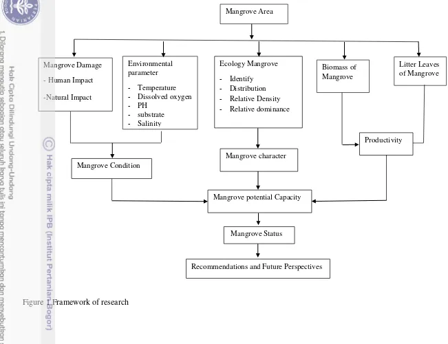
Framework of Research
5
5 Mangrove Area
Biomass of Mangrove Environmental
parameter - Temperature - Dissolved oxygen - PH
- substrate - Salinity
Litter Leaves of Mangrove Ecology Mangrove
- Identify - Distribution - Relative Density - Relative dominance Mangrove Damage
- Human Impact -Natural Impact
Productivity
Mangrove Condition
Mangrove potential Capacity
Recommendations and Future Perspectives MangroveStatus
Mangrove character
6
2 RESEARCH METHODOLOGY
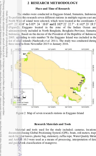
Place and Time of Research
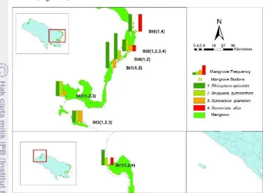
The studies were conducted in Enggano Island, Sumatera, Indonesia. To perform this research seven different stations in multiple regions east and North West of island were selected, which were located at the coordinates S 05⁰: 25ʾ 43.0” to S 05⁰: 24 ʾ 10.0” and E 102⁰ 22ʾ 22.7” - E 102⁰23ʾ 19.5” (Figure2). Enggano located in the zone of the Indian Ocean and administratively included in North Bengkulu, Bengkulu Province, Sumatra, Indonesia. Based on the decree of the President of the Republic of Indonesia 2005, according to rule number 78 the Enggano Island was included in the list of small islands (Nashsyah et al. 2011). The study was conducted during three months from November 2015 to January 2016.
Research Materials and Tools
Material and tools used for the study included; cameras, locations documented using Global Positioning System (GPS), boats, roll meters, traps mesh for litter leaves, plastic bag, stationery, raffia rope, Water Quality Meter and ArcGIS 10.3 were used as a means of processing, interpretation of data and guidebook classification of mangrove.
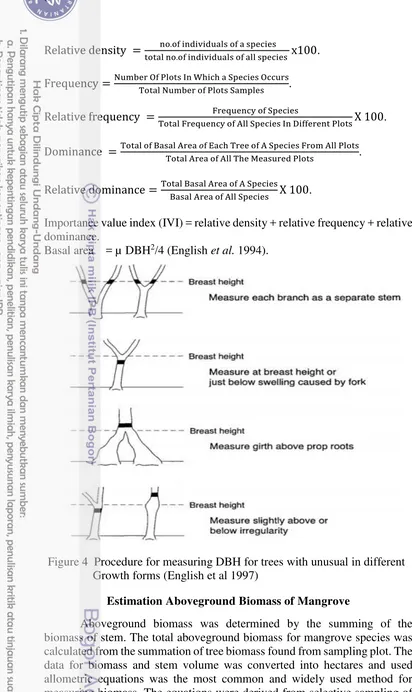
Method of Data Collection and Analysis Character of Mangrove
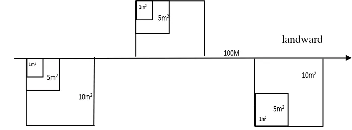
Mangrove species identification, in the work beginning in the field, it has been classified as mangrove species which found within the study areas by guidebook (Noor et al. 2006) and characters of mangrove ecosystems, consisting of population density, relative density, importance value index, frequency, relative frequency, dominance, relative dominance, and stand basal area (English et al. 1994).The methods used in this study range from ecological fieldwork to implementation, the quadrant transect method was applied (English et al. 1994). The data was collected at 100 m2 quadrat at random sampling points. Made seven stations laid perpendicular to the shoreline (Figure 3). In order to cover all conditions of the research sites on each transect, the random sampling points were taken using a 10 m×10 m quadrat for each plot.
Plots were laid at seven stations to take samples. Plots were set up at representative areas in mangrove forest, line transects were used from seaward to landward (perpendicular to the coastline along the mangrove forest zoning) in the intertidal area. In addition to made the plot size of 10 m x 10 m for an adult tree, 1 x 1 m (English et al. 1994), the seedling and 5 x 5 m for the sapling (Bengen 2002) to assess the condition of mangrove, the determination of vegetation of mangrove for each specie was counted the number of individuals and density of each type and size of each circle mangrove trunk at breast height about 1.3 m for the trees mangrove adult diameter > 4 cm (Figure 4). The method used was single plot random repetition, where the technique to make sub-plot followed the growth stage (English et al. 1994).
Variables observed, calculated, and analyzed in the study were: (1) Identification of mangrove species used by the guidebook (Nor et al. 2006), (2) Character of mangrove ecosystems, the data gathered was analyzed using the parameters: population density, relative density, importance value index, frequency, relative frequency, dominance, relative dominance and basal area.
landward
Relative density = . . x .
Frequency = I W .
Relative frequency = y y I X .
Dominance = � .
Relative dominance = X .
Importance value index (IVI) = relative density + relative frequency + relative dominance.
Basal area = µ DBH2/4 (English et al. 1994).
Estimation Aboveground Biomass of Mangrove
mangrove trees that are representative of the size-classes in the forest to estimate the partial weight of trees relative to tree metrics, such as diameter breast height (DBH) and tree height (Suzuki and Tagawa 1983).
� = � ∗ ��� ∗ � �, were Y = biomass value is a dependent
variable, DBH = Trunk Diameter (diameter at breast height). Where a and b are regression constant = (Rhizhophora = 0,101; Bruguiera = 0.150; and others = 0.145), H = Height of tree, a = coefficient (Rhizhophora = 0.931; Bruguiera = 0.784 and others = 0.827) D = Density (ind/ha), (Suzuki and Tagawa 1983).
Estimation of Productivity Litter Leaves of Mangrove
Litter traps were constructed taking into consideration the mesh size (Brown, 1984). The litter trap must not retain moist but must be dry as any presence of moisture will enhance the process of decomposition which may reduce the weight of the litter (Mohit and Appadoo 2009). The trap was made from nylon fabric a mesh size of 1 mm × 1 mm of the trap was suitable enough to prevent any loss of litter materials caused by the constant bouncing out of the litter traps to the mangrove trees as a result of strong winds. The litter traps had a Square frame of one meter which made up of raffia rope. Square frames of raffia ropes were constructed to facilitate the handling of the litter baskets and also for them to be easily fitted among the mangrove trees. Traps were placed in different stations. Each litter trap was attached tightly to the trunk of the mangrove trees above the high-tide more than mark 0.5 m (Cunha
et al. 2006). The litter traps were emptied during the two-week period starting at the first December 2015, the litter leaves were collected in plastic bags from sixteen traps of different stations and were taken to the laboratory, were dried at 70°C for 3 days and then calculate and analyze weights According to the following equations:
Dry Weight of litter g DW
Area Traps m = g DW m−
The dry weight of litter (g DW) for each litter trap is calculated in a surface area of 1 m2.
Dry Weight of litter g DW m−
Number of Days Between Each Collection Date = g DW m− day −
The rate of litter fall is then calculated by dividing the dry weight of litter (g DW m− ) by the number of days between each collection date(Abib and Appadoo 2012).
Environmental Parameters
forests sampled, and to find out similarities in all samples stations for analysis of the environmental situation. Sediment samples at each mangrove site were determined for substrate (sand, silt, and mud) to identify the type of substrates in the mangrove areas in transect quadrats.
3 RESULTS AND DISCUSSION
Character of Mangrove Vegetation
The characterization of the plant structures of mangrove was based on the methodology proposed by (English et al. 1994), which recommended that the use of multiple squares, the replication of samples in order to be more representative and to allow for more robust statistical analysis. In each location, seven station were chosen and each area was marked by transects of 3 quadrats measuring 100 m2 for each plot. An observation of the characteristics of mangrove vegetation in this study concerned on the seven observations of differnt locations as the focus for the relative frequency, importance value index, estimate the above ground biomass and their relationship with a basal area of the mangrove trees and identification of the species within the study areas. Frequency is the number of sampling units in percent in which a particular specie occurs as the probability of finding the any specie in plot and only be compared between plots of equal size, importance value index, estimate the above ground biomass and their relationship with a basal area of the mangrove trees andidentification of the species within the study areas (English et al. 1994).
Relative Frequency
The frequency is the number of plots on which species occurs divided by the total number of plots sampled. Frequency data was used to detect changes in plant abundance and distribution on a range site over time or to identify differences inspecies responses to varying management practices. Selection of the proper plot size is extremely important for estimation of frequency, and more than one plot size may be needed for varying plant species and plant distribution. Frequency data was easily obtained, but numerous sample plots must often be evaluated before reliable estimation can be derived. Most species in mixed mangrove forest give frequency above 0.05. This indicates that all plot samples have mangrove species. Most of the plots were dominate with Rhizophora apiculata because this species showed the highest total of frequency 0.85. Rhizophora apiculata indicated the highest total of the important values compared to the other three mangrove species which was derived from the total relative density, relative dominance and relative frequency. If the species showed a higher important value indicated that species was in abundance and can be founded diversely in the study areas as pioneer species (kasawani et al. 2007).
station 1, Bruguiera gymnorrhiza 43% in station 2, Sonneratia alba 50% in station 6 and Xylocarpus granatum 33.3% in station 3 and It was observed that the relative values of Rhizophora apiculata type was the highest in all stations (Figure 5).
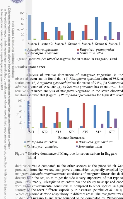
Relative Density
The highest existed density was for Rhizophora apiculata trees because it has high ability of adaptation in different environmental conditions. This specie was founded in the intermediate estuarine zone in the mid-intertidal region. This specie tolerates a maximum salinity of 65 ppt and a salinity of optimal growth of 8 to 15 ppt (Robertson and Alongi 1992). It is hard and fast-growing specie. This specie can grow upto 30 m. Based on the performed observation and analysis of mangrove ecosystem in the seven stations (Figure 6), relative density was calculated by percentage founded in every observed mangrove vegetation the highest percentage of the species density from all stations (1) Rhizophora apiculata 95 %, (2) Bruguiera gymnorrhiza 57 %, (3) Sonneratia alba 29 %, and (4) Xylocarpus granatum
17 % Figure 6. Relative density analysis shows that the Rhizophora apiculata
is the most dominant mangrove specie in all study stations. The notable volume of Rhizophora apiculata shows that it is the most adapted species in Enggano Island. The fruit of Rhizophora apiculata has good adaptations in terms of dispersal and establishment. It can almost grow and thrive on its own. Therefore, Rhizophora apiculata can be considered as the best option in the efforts of mangrove reforestation.
Relative Dominance
Analysis of relative dominance of mangrove vegetation in the observed seven station found that: (1) Rhizophora apiculata value of 98% in station one, (2) Bruguiera gymnorrhiza has the value of 91%, (3) Sonneratia alba has a value of 35%, and (4) Xylocarpus granatum has value 22%. This relative dominance analysis of mangrove vegetation in the seven observed locations showed that (Figure 7)Rhizophora apiculata has the highest relative
dominance value compared to the other species at the place which was protected from the waves, mangrove communities especially excelled by mangrove Rhizophora apiculata and conditions of mangrove forests that deal directly with the sea, so as to get the tide is very supportive of that type to grow. Presumably, Rhizophora apiculata has the ability to adapt and cope with larger environmental conditions as compared to other species in high salinity or the level different especially in estuaries (Sambu et al. 2014).
Which explained its wide adaptability in different areas. The mangrove trees
studied in Enggano Island were founded to be dominated by Rhizophora
Station 1 station 2 Station 3 Station 4 Station 5 Station 6 Station 7
Rhizophora apiculata Bruguiera gymnorrhiza
Xylocarpus granatum Sonneratia alba
%
Figure 6 Relative density of Mangrove for all station in Enggano Island
0
apiculata, presenting reduced structural development and low density for
Sonneratia alba and Xylocarpus granatum.
Presumably, Rhizophora apiculata has the ability to adapt and cope with larger environmental conditions as compared to other species in high salinity or the different levels especially in estuaries (Sambu et al. 2014). Importance Value Index
Importance value index of mangrove vegetation ranges from 0 to 300 (Sambu et al. 2014). This IVI will become an overview about the influence or role of a plant in the community within vegetation ecosystem. To find out the IVI was calculated and analyzed for both relative density, relative dominance, relative frequency, analysis of IVI of mangrove vegetation details refers (Table 1), (1) Rhizophora apiculata reaches 267.57 highest importance value index in the first Station and lowest was in station five. (2) Bruguiera gymnorrhiza 181 highest IVI value in station five and showed the less valuable in station seven are value 74 in terms of dominance. (3) Xylocarpus granatum the highest IVI value was 73 in station three, Lowest IVI value 22. (4) Sonneratia alba 89 station seven and lowest was 22 in station five. The Zero values in some stations is non-existence for a type. The findings showed that specie Rhizophora apiculata has the most dominant influence in the four type’s mangrove ecosystems. Based on the observed and analysis of importance value index of mangrove vegetation, the composition of vegetation in the observed seven locations has heterogeneous, as it is shown by the observation and analysis of the four-species mentioned, but it has low-level heterogeneity. In fact, one of the indicators that mangrove ecosystem is healthy when it has high heterogeneity or when the ecosystem has high biodiversity.
Table 1 Important value index of Mangrove species for all station in Enggano Island
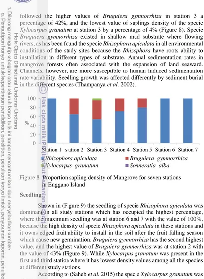
Saplings
Sapling category was founded in the study sites includes three species
followed the higher values of Bruguiera gymnorrhiza in station 3 a percentage of 42%, and the lowest value of saplings density of the specie
Xylocarpus granatum at station 3 by a percentage of 4% (Figure 8). Specie
Bruguiera gymnorrhiza existed in shallow mud substrate where flowing rivers, as has been found the specie Rhizophora apiculata in all environmental conditions of the study sites because the Rhizophora have roots ability to installation in different types of substrate. Annual sedimentation rates in mangrove forests often associated with the expansion of land seaward. Channels, however, are more susceptible to human induced sedimentation rate variability. Seedling growth was affected differently by sediment burial in the different species (Thampanya et al. 2002).
Seedling
Shown in (Figure 9) the seedling of specie Rhizophora apiculata was dominant in all study stations which has occupied the highest percentage, where the maximum seedling was at station 6 and 7 with the value of 100%, because the high density of specie Rhizophora apiculata in these stations and it owns edged fruit ability to install in the soil after the fruit falling season which cause new germination. Bruguiera gymnorrhiza has the second highest value, and the highest value of Bruguiera gymnorrhiza was at station 2 with the value of 43% (Figure 9). While Xylocarpus granatum was present in the first and third station where it has lowest density values among all the species at different study stations.
According to (Saheb et al. 2015) the specie Xylocarpus granatum was highly sensitive to high water level and very low water levels, especially at early development stage, the favorable water levels range for seed germination at 3 cm to 2 cm from the soil. Example in the position of seed, radical should be connected with soil. Wilted nature of primary roots, position of seeds in the soil may be a difficult situation for establishment of Xylocarpus granatum. Photosynthetic performance of plants reflects seed germination pattern. Thus, artificial breeding and culture should be adopted to ensure a higher survival rate of Xylocarpus granatum seedlings. Due to these difficulties, seedling establishment at botanical garden of ANU took up 3 to 4 months. The above studies are a step towards understanding the
Station 1 station 2 Station 3 Station 4 Station 5 Station 6 Station 7
Rhizophora apiculata Bruguiera gymnorrhiza Xylocarpus granatum Sonneratia alba
%
distributional and propagation difficulties of an important mangrove plants. As well the mangroves seedling occur in tropical habitats where they are exposed to high light intensities. The intense light can damage the mangrove seeds and drop the photosynthetic rate (Cheeseman 1994). Rhizophora
seedlings were not significantly affected by the burial levels. Seedling impaired if they are covered by sediment, tropical rivers carry massive amounts of sediments during the rainy season (Milliman and Meade 1983) which are discharged into coastal waters, frequently as sudden high-sedimentation events. Such events can cause extensive burial of the mangrove aerial roots, inhibit root aeration, and consequently, lead to widespread mortality (Ellison 1999).
Mangrove Condition in Enggano Island
The mangrove system is very dynamic, where changes take place regularly, and within the range of mangrove habitats, most major species grow within a given set of conditions. Mangroves are salt-tolerant forest ecosystems of tropical and subtropical intertidal regions. They occur in sheltered coastline areas such as small bays, estuaries, lagoons, creeks and sea channels separating islands and certain locations where the soil conditions are favorable such as mud flats and swamps. Mangroves are highly productive intertidal ecosystems in tropical and subtropical regions. Despite the established importance of mangroves to the coastal environment (Chellamani
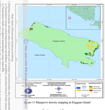
et al. 2014), But the mangroves are among the most degraded ecosystems in the World (Peter 2013). Degradation of this system continues mainly due to anthropogenic pressure (Chellamani et al. 2014). Human activities and natural disaster may bring affect for mangrove existing and its density. Solid waste and sediment as in some stations 5, 6 in the study area is one of problems leading to the decrease of mangrove forest area in kaya apo village. In order to assess mangrove distribution, the mangrove density changes should be monitored through mapping.
In this research, mangrove density was divided into 3 classes build upon histogram of NDVI transform which adjusted in Landsat images. Mangrove density classes were divided as sparse, moderate and dense based
0
Station 1 station 2 Station 3 Station 4 Station 5 Station 6 Station 7
Rhizophora apiculata Bruguiera gymnorrhiza
Xylocarpus granatum Sonneratia alba
%
on NDVI range in images. The coverage area of mangrove density classes is shown by (Table 2). Types of mangrove dominated in Enggano Island were
Rhizopora apiculata, Bruguiera gymnorrhiza, Sonneratia alba, and Xylocarpus granatum. Image processing from Landsat 8 divided mangrove density into 3 classes based on NDVI range from Ministry of Forestry therefore, the mangrove ecosystem could be visually observed in good status (based on Decree of the Minister of Environment No.201/2004 – Criteria and Guidelines for Determining Mangrove Damage). Density classes are spares (NDVI range: -1 to 0.33; equal with < 1 000 Trees/Ha), moderate (NDVI range: 0.33 to 0.42; equal with ≥ 1 000 to < 1 500 Trees/Ha), and dense (NDVI range: 0.42 to 1; equal with ≥ 1 500 Trees/Ha).
Dense Vegetation: Dense mangrove shows good health status of mangroves which indicates tall trees, fine distribution, diversity extent and excellent local habitat for the mangrove growth. Mangrove covers the area of about 661.2 ha area coverage 55.5% (was taken as dense mangrove vegetation. Mangrove in Enggano island are dominated by Rhizopora apiculata, Bruguiera gymnorrhiza, Sonneratia alba, Xylocarpus granatum. Overall, in this study mangrove community in Enggano island has good density for Rhizopora apiculata 63%, Bruguiera gymnorrhiza 27%. It was shown by dense mangrove coverage area.
Relative density of the mangrove species in all stations based on the identification and analysis, mangrove ecosystem for each species found is given as (1) Rhizopora apiculata 63%, (2) Bruguiera gymnorrhiza 27% (3)
Sonneratia alba 6%, and (4) Xylocarpus granatum 5%. Relative density analysis shows (Figure 10). Shows that Rhizopora apiculata was the most dominant specie. Presumably, it has not only vastly zonation but also have fast growth rate compared to other vegetation types.
Moderate Vegetation: The canopy covers the area of about 467.3 ha with percentage 39.2% which is taken as moderate vegetation of mangrove forest, the dominant variety in the entire mangrove forest of the Enggano Island.
It highlights the moderate health of the forest. It will probably be species
Sonneratia alba, with moderate density , as evidenced by the results of the 63%
27%
5%6%
Rhizophora apiculata Bruguiera gymnorrhiza
Xylocarpus granatum Sonneratia alba
analysis in the field study stations that showed the presence of a weak density 6% and lack of presence in some stations, but was seen have more density out side the stations.
Degraded Vegetation: The degraded forest denotes the loss of canopy cover, lower-stand density and degrading forest habitat due to changes in environmental conditions and natural factors such as storms in around mangrove (Kuenzer et al. 2011). The canopy cover indicates the mangroves condition. Both the salt tolerant and riverine mangroves was present in this vegetation type and cover around 62.3 ha with percentage 5.2% (Table 2), in the areas of Enggano Island, which shows the maximum percentage of degradation of mangroves in study stations where Xylocarpus granatum
presence was about 5% (Figure 6). Which represents the lowest percentage of species of mangrove located within the field study. The factors affecting the mangrove environment in Enggano Island were sediment, due of the land reclamation and development work. Sediments are material of varying size of mineral and organic origin. The process of deposition of sediment from a state of suspension or solution in a fluid is called sedimentation.
Table 2 Coverage area of classified Mangrove density year 2015 in Enggano Island
Natural sources of sediments transported to the sea include erosion of bedrock, soil and decomposition of plants and animals (GEMS and Programmes 2006). Natural sediment mobilization is an important process in the development and maintenance of coastal habitats, including mangroves, dunes and sand barriers. However, anthropogenic activities or those which are carried out by man, often change the processes of erosion and sedimentation as well as modifying the flow of rivers and the amount of sediments that it can carry. The effects of changes to sedimentation patterns depend on whether the change results in an increase or decrease in sediment availability. Both effects have various physical and chemical consequences for water quality and aquatic ecosystem health. Increased sedimentation in the study area through the Rivers has smoothen marine communities and in severe cases it will burial leading to suffocation of corals, mangrove stands and sea grass beds. It has also caused intrusion of many toxic organic chemicals, heavy metals and nutrients which were physically and/or chemically absorbed by sediments (Peter 2013).
Environmental Parameters
Spatial agglomerative hierarchical clustering (AHC) was carried out for all stations sampling sites in the waters of area mangrove in the coastal Enggano Island. AHC generated a dendrogram grouping the sampling sites into 3 clusters (Fig 12). This step was carried out to find out if there are similarities between the water qualities of the Enggano Island.
The First group: were similar environmental conditions somewhat in stations 2, 3, 5 and 7. Where the tree mangrove Rhizophora apiculata in terms of density and the dominance and also the dominant was Bruguiera gymnorrhiza in the station 2 and 5 due to this it has possession of large trunk which located in the mouth of the river with a silty substrate. At station 3 water was supply from river, especially in the direction of the land and the type substrate muddy sand, Rhizophora apiculata found in front area toward Sea characterized by the presence of shrubs and sapling where a low tidal amplitude prevails and protected from the waves because of the marine tongues, And represented dominance the adult trees of the species Bruguiera
gymnorrhiza concentrated toward the mainland in some stations. At seventh station the substrate muddy sand within the mouth of the river, the mangrove trees specie available was Rhizophora apiculata, followed by Sonneratia alba, which was accounted for a higher presence within the study in this station, the station environmental conditions were similar to mentioned stations somewhat in both standards as dissolved oxygen, salinity, pH, temperature and substrate.
A second group: It was the dissolved oxygen value higher than other stations, in the first station because this area direct contact with estuary it has dissimilar with the other stations almost environmental parameters of the amount of dissolved oxygen when sampling. Where focused mangrove specie
Rhizophora apiculata near of the estuary and the little presence of Xylocarpus granatum trees in the land direction.
The third group : In the fourth and sixth station found also similar environmental conditions in accordance with the parameters pH, salinity, dissolved oxygen, and the substrate in station 4 was muddy sand and in the sixth station substrate sandy Concentrated on the mainland direction and the specie Rhizophora apiculata Predominant in this region. Average water quality status for disturbed and undisturbed mangrove in the stations study, where was the range average for water quality parameters in the stations temperature was 28.8˚C ± 31.5˚C and the pH 7.2 ± 8.5, salinity 32.4 ± 24.7 where not exceed more than 35 ppt and dissolved oxygen 6.9 ± 1.2 mg/l. Thus the water tides and other factors give impact to the water quality parameters fluctuation (Pawar 2013). These temperature values were within the acceptable levels for survival, metabolism and physiology of aquatic organisms. According to present research results temperature has some positive and negative effects on plant growth. The most suitable water temperature for plant growth is 20°C to 35°C, Temperature over 30°C can cause regression in growth and decay in plants (Lawson 2011).
Results showed that the pH value of water may increase due to the mixing of estuaries water generally average pH of 7.0 to 7.5 with sea water that have pH mainly in range of 8.1 to 8.3 (Edzwald and Haarhoff 2011). Dissolved oxygen is vital to aquatic life, as it is needed to keep organisms alive. Coastal water typically require a minimum of 4.0 mg/l and also do better with 5.0 mg/l of oxygen to provide for optimum ecosystem function and highest carrying capacity (UNESCO/WHO 1978). Example if sewage and other wastes (e.g. from food processing) as trees rubbish with high Biological Oxygen Demand (BOD) are discharged into the sea (Clark 1996). It observed at stations 2, 3, 4, 5 and 6, decreased dissolved oxygen value when sampling was to high number of litter fall and organic matter in the water bodies (Patnaik 2005).
be typical for mangrove ecosystems where it assures an essential import of nutrients.
Mangroves function physically as sediment sinks where suspended solids are filtered out of the water resulting in a positive effect on the associated coral reefs and sea grass beds laying off shore. High siltation negative effects on plant performance occur when suspended solids accumulated too fast in the mangrove ecosystem. Moderate sedimentation rates can be positive for mangroves leading to enhanced growth of the trees (Ellis et al. 2004). In particular, the enhanced phosphorus availability would be helpful for the growth of mangrove trees (Nye and Tinker 1977). On the other hand, high sedimentation rates which exceed 1 cm/ year would increase death ratio within the mangrove forests (Ellison et al. 1998). Mangrove plants are shown lower growth under high siltation rate (Vaiphasa et al. 2007). Number of recent studies indicate that the loss of 100 ha of mangrove ecosystems by the deposit of dredged-up sediment originating from the Mokowe Sea Jet construction in Kenya (Aheto et al. 2001). High siltation not only influenced mature trees, but also their seedlings encounter many trouble and die due to siltation. High siltation perturb the life cycle of mangrove trees which leads to a faster decline of the forests and makes growth of plants more difficult.
Estimation Aboveground Biomass and Stand Basal Area of Mangrove Species
Mangrove plays a significant role in climate change mitigation particularly in carbon absorption and minimizing the detrimental impacts of sea level rise, salt-water intrusion and tidal surges. (Camacho et al. 2011), and serve as both sources and sinks of atmospheric CO2. They can be managed to sequester CO2 and store carbon in biomass and soil. Further, mangroves perform protective roles against detrimental climatic impacts.
3 5 2 7 1 4 6
(Gevana et al. 2008). Total plant biomass for mangrove trees (ton/ha) was determined by summing the aboveground biomass (AGB) and belowground biomass (BGB). Vegetative carbon (tonC/ha) was calculated from total plant biomass, assuming 50% of carbon in vegetative biomass. (MacDicken 1997). Estimates of stand biomass provisions provides indication of carbon allocation to plant tissues, which is a vital information with regard to local as well as regional carbon accounting or sequestration (Kairo et al. 2008).
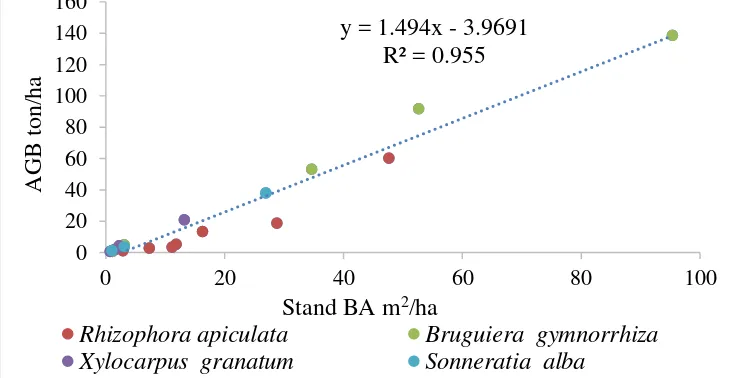
The total aboveground biomass of mangroves was best estimated by linear equations in the components of the mangrove species using DBH, Height and (DBH*H) as the independent variables. However, the combined form of the DBH and Height (DBH*H) gave the best coefficient of correlation and hence was used in the estimation of the standing biomass of mangrove according to (Suzuki 1999). And also, the basal area, it was calculated according to the equation (English et al. 1994). The highest values of stand basal area and above ground biomass for each specie as follow: Bruguiera gymnorrhiza with 95 m2/ha, 139 ton/ha in station 5, due to the existence of long-lived trees with trunks large in the land direction, also be the dominance species in this study followed by 48 m2/ha, 60 ton/ha Rhizophora apiculata in station 7 which existed within the estuary, 27 m2/ha, 38 ton/ha Sonneratia alba in station 7. While the finally dominance recorded by Xylocarpus granatum 13 m2/h, 21 ton/ha in station 3 (Table 3), respectively. Where
Rhizophora apiculata gave the highest value in the estuarine area which a substrate muddy-sand or silty was maximum at station which was located close to the mouth of the estuary seafront and fewer value toward the direction of the land. Bruguiera gymnorrhiza species it has founded away from the shoreline also within the estuary and has the high value in some stations because it owns a large basal area, which existed in the sand and mud substrate. Furthered explained that the above ground biomass tends to be relatively low in stands near the sea and increases inland.
The amount of standing aboveground biomass stored in a forest is a function of the system’s productivity, age and organic matter allocation and exportation strategies. The total aboveground biomass for mixed mangrove forest in Enggano Island was 139 ton/ha Bruguiera gymnorrhiza recorded the highest total aboveground biomass in station 5 because of a wide range of diameter and height. Total aboveground biomass for Rhizophora apiculata
trees was 60 ton/ha. A different total of aboveground biomass influenced by trees diameter. Most of the individual’s trees in Rhizophora apiculata and
Bruguiera gymnorrhiza forest type have a wide range of diameter.
The results of this research were comparable to the findings on the study in Sarawak, Malaysia of amount mangrove above ground biomass of
Rhizophora apiculata were 116.79 ton/ha. (Arianto et al. 2011), again according (Komiyama et al. 1988) to the findings the biomass ranged from 436.4 ton/ha in tall Rhizophora apiculata forests in Indonesia. And
species in Enggano Island this might have been attributed by human activity, environmental and climate changes. From the findings, it was depicted that there was a significant indirect effect of a change of characteristic of mangrove forest due to human encroachment evidence by the reduction in
Xylocarpus granatum and Sonneratia alba species population. Therefore, there is need for environmental mitigations to preserve the ecosystem.
Table 3 Estimation Aboveground Biomass (AGB, ton/ha) stand Basal Area (Stand BA m2/ha) of Mangrove for all station in Enggano island
Correlation between Stand Basal Area and Aboveground Biomass of Mangrove
Over the past decades, allometric equations have been developed for various tree species and forest types including mangroves. The main parameter that is usually used for defining the relationship was biomass weight and diameter at breast height (DBH). Sometimes, tree height (H) is included but to obtain accurate height data is difficult, especially when canopy and tree density are high. In this study, obtained both DBH and height. Where the basal area depended on the trunk DBH and aboveground biomass relied on DBH, Height (DBH*H) as the independent variables and consideration the density of each species. (Suzuki and Tagawa 1983).
biomass of mangrove in seven station was 145 ton/ha. Following in the Seventh station the total values reached both aboveground biomass 103 ton/ha and stand basal area 78 m2/ha. From the data analysis showed linearly increased with an increase of basal area, aboveground biomass was strongly related to the basal area in mangrove forests as results of correlation R2 = 0.955 (Figure 13). When stand BA increase 1 m2/ha, the biomass increased by 1.494 ton/ha. It appears that fourth station was least value of the presence of aboveground biomass per unit area, the fact that this station does not contain large trees, but trees with small trunk centered near the coast line and lack of river water flow from the direction of the land. Plots with higher biomass were generally located closer to the border with the Transitional forest, while high-biomass plots were farthest from the coast. This gradient of decreasing biomass with distance from the coast within the mangrove area, may be a widespread pattern watershed, if not more generally. For example, in station five along a transect direction to land the mangrove trees were have large trunks and high which existed in mud soil predominantly. It has been shown to the value to increase the basal area gave increased aboveground biomass values.
Estimation Productivity Litter Leaves of Mangrove in Enggano Island Importance of mangroves to sustain productivity in estuarine and coastal ecosystems depends on both the transport and utilization of organic matter from mangroves. Based on mass balances, some mangrove-estuarine ecosystems transport substantial amounts of organic material to estuarine and coastal waters. Also, mangroves may benefit several fisheries by providing habitat during certain stages of their life cycle rather than serving only as a source of food. Several excellent analysis of trophic food webs in mangrove ecosystems, such as that by (Odum and Heald 1972), have demonstrated that mangroves are utilized for food and habitat. Evidence from stable isotope
studies suggest that the utilization of mangrove detritus may vary depending on its quantity relative to other sources of food (Macko and Zieman 1983), There is some indication that nutrient resorption can vary within a mangrove species in different environments. The mass/nutrient ratio of nitrogen in leaf litter relative to nitrogen return to the forest floor via litterfall is an index of nutrient-use efficiency. High efficiencies of Rhizophora occur in trees located in either riverine or fringe forests (Twilley 1988). In riverine and fringe mangrove forests where leaf exportation is high, higher nutrient recycling efficiency in leaves prior to leaf fall is an advantage to increasing nutrient conservation. Increases in nitrogen concentration of leaf litter during decomposition may immobilize nitrogen in basin mangrove forests, effecting within system nutrient conservation (Brinson 1977; Vitousek 1984).
Nitrogen enrichment of leaf litter includes absorption and adsorption processes by bacterial and fungal populations (Rice 1982), as well as nitrogen fixation (Zuberer and Silver 1978; Gotto et al. 1981). These inputs of nitrogen results in an absolute increase of nitrogen in decomposing litter, and particularly for Rhizophora leaf litter, recycling of nitrogen on the forest floor (Twilley et al. 1986). Island mangrove forests have higher decomposition and mineralization rates of leaf litter and along with infrequent tides, have lower rates of detritus export. Thus high litter turnover may increase the availability of nutrients for reabsorption by roots and prevent the loss of nitrogen from the system. This study interested on leaves litter due the leaves litter form the largest portion of the total litterfall and hence constitutes a significant input of organic matter, Leaf litter comprised the largest portion 77% to 84% of the total annual litterfall. Non-leaf plants of mangrove litter account only for 2-10% of the total litterfall in these mangrove ecosystems. (Amarasinghe and Balasubramaniam 1992).
The results analysis showed that the values of litter leaf production of mangrove individuals in Enggano Island for the four species of mangrove daily averages of dry weight litter leaves dry weight (gDW m-2 day-1) was summarized in the (Figure 14). Values for Bruguiera gymnorrhiza was 2.9 gDW m-2 day-1, followed by Xylocarpus granatum 2.7 gDW m-2 day-1 ,
Rhizophora apiculata was 2.6 gDW m-2 day-1 and Sonneratia alba 2.5 gDW m-2 day-1. Where the highest productivity of mangrove species was in the
0.0
stations as follow Rhizophora apiculata in station 1 and 3, Xylocarpus granatum in station 3, Bruguiera gymnorrhiza in station 2 and 5, Sonneratia alba in station 6.
The results of this research were compared with previous studies conducted in Australia Missionary Bay, where the result of productivity of leaves litter for mangrove species, Bruguiera gymnorrhiza litter leaves 1.37 gDW m-2 day-1, Sonneratia alba 1.06 gDW m-2 day-1, and average for all sites and seasons Rhizophora apiculata 1.56 gDW m-2 day-1 (Duke et al. 1981). It confirmed the productivity of litter leaves of mangrove in Enggano Island was a higher than in result of the study above mentioned. The productivity differences of mangrove trees depending on the spatial and temporal and other factors such as the wind etc. Leaves, generally, made up the most important component of all litter materials (Duke et al. 1981). Although wood fall appears to be unimportant, it may not be the reality as dead trunk fall has not been taken into account according to (Amarasinghe and Balasubramaniam1992).
In the present study, leaf litter productivity of mangrove was little different among all species, the total leaf litter at both stations was more or less the same compared to different stations. This could be due to variation in different environmental parameters such as growth condition, a height of the tree, salinity, temperature, evaporation, wind speed and nutrient input etc., which regulate the production rate (Heald 1971; Lugo and Snedaker; 1974; Juman 2005). Tree height (growth condition) has been particularly considered as one of the major controlling factors in litter production by (Woodroffe et al. 1988). And it was proposed by (Farooqui et al. 2012) that wind speed is a more dominant factor than tree height in controlling the litter production in area. according to (Twilley and Day 1999) Litterfall values for mangrove forests worldwide range from 2 to 16 t ha-1 per year, and the results in this research are compatible with the previously stated when converting the productivity values g.m-2.day-1 to ton.ha-1.year-1 an annual yield gives the highest value of the average individual productivity of litter leaves was
Bruguiera gymnorrhiza 10.5 to DW ha year-1, Xylocarpus granatum 9.7 to DW ha year-1, Rhizophora apiculata 9.3 to DW ha year-1 and 9.1 to DW ha year-1for S. alba which was the lowest value.
Correlation between Productivity Litter Leaves and Diameter Breast Height of Mangrove in Enggano Island
Mangrove leaves are shed continuously and the dominant component of litterfall throughout the year, with rates varying from habitat to habitat. Accordingly, mangroves are thought to be significant contributors to estuarine and inshore productivity via litterfall according by (Day et al. 1987). In this study, the analysis showed productivity and their relationship with diameter breast height (DBH) of mangrove in Enggano Island, has found four species. Through the calculated for the productivity per meter square per day and diameter breast height from the circumference of mangrove trees represented in correlation as in (Figure 15) showed the highest values of leaves litter individuals for each species and diameter breast height(DBH),
gDW m-2 day-1, 45 cm, Bruguiera gymnorrhiza 2.9 gDW m-2 day-1, 62 cm,
Sonneratia alba 2.6 gDW m-2 day-1, 30 cm, respectively.
From the data analysis showed linearly increased with an increase of diameter breast height (DBH), productivity (dry weigh of litter leaves) was strongly related to the (DBH) in mangrove forests as results of correlation for each species to show relationship of the productivity and diameter breast height (DBH) of samples individuals for mangrove species, Illustrated by the results of the analysis as shown in (Figure 15). Sonneratia alba R2= 0.978,
Rhizophora apiculata R2= 0.9007, Bruguiera gymnorrhiza R2=0.889 and
Xylocarpus granatum R2= 0.777, where was the stronger correlation coefficient for Sonneratia alba than other species. Proved that the relations between diameter breast height and the litter leaves productivity of mangrove trees was correlation strong particularly for specie S. alba was the highest correlation and the lowest in specie Xylocarpus granatum. Rate of litter production is generally affected by geographical location, type of forest and sediments, water stress during hot and dry periods, high winds and storms and fresh water drainage and also there was a role for the trees height (Cox and Allen 1999). These factors contribute to variable litter productivity among forests consisting of different species and among same species located at
4 CONCLUSION AND RECOMMENDATION
Conclusion
Based on the field study and results of data analysis, it’s concluded that for the four species of mangrove vegetation indicates that vegetation level was heterogenetic and it is dominated by specie Rhizophora apiculata in both of the relative density, relative frequency, and Important Value Index and were the highest values for Rhizophora apiculata and Bruguiera gymnorrhiza. Analysis showed above ground biomass and basal area, it has been shown to the value to increase the basal area gave increased aboveground biomass values. It has been proven that linearly increased with an increase of basal area, aboveground biomass was strongly related to the basal area in mangrove forests as results of correlation coefficient R2 = 0.955. When basal area increase 1 m2/ha the biomass increased by 1.49 ton/ha. From the findings, it’s depicted that there is a significant indirect effect of a change of character of mangrove forest due to human encroachment evidence by the reduction in Xylocarpus granatum and Sonneratia alba species population. As well the low density presence of the both seedlings and sapling because of the high of the sediment settled in the mangrove areas due to land reclamation on the island and acts of development. According to the classification of the density as described above, therefore, there is the need to mitigation environmental pressures for preserve the ecosystem. It also concluded through analysis that the increase in the diameter breast highest of mangrove trees gives increased productivity of litter leaves in individuals, the species
Recommendations and Future Perspectives
1. Continuing research on the productivity of the mangrove trees in different seasons and their relationship to fish stock.
2. Rapid implementation measures that will stop the arrival of sediments across streams and rivers to the mangrove areas.
3. Establishment of administrative office regarding to the implementation of administrative tasks and follow-up continuing coordination with other administrative authorities.
4. Preparation and implement plans aim at conservation and preservation mangrove as well management practices of community participation in the rehabilitation of mangrove trees and conservation to ensure the survival of natural resources and also the restoration of degraded species. 5. Implementation of training programs concerning the conservation and rehabilitation of mangrove forests for community. For instance, train the community about the planting techniques, organization management and community forest laws and constitution. The training will help to bring awareness to the community about the importance of managing mangrove forests sustainably.
6. Dividing the mangrove forests into four zones. The first zone is protected zone. It indicates the “No Touch” reserve areas of pristine forests for biodiversity maintenance, scientific research and education, fisheries support, and coastal protection. The second zone is productive forest which specifies the sustainable yield of forestry and fisheries products. Next is the reforestation zone. It indicates the degraded areas of ecological importance including Areas affected by natural factors such as storms and others, as well as areas affected by sediment brought by rivers. Which need to be rehabilitated. The last zone is conversion zone (Figure 16). It is the allowable area to convert mangrove forests to aquaculture or agriculture but not exceeding 20 per cent of total mangrove area, (according suggested by Primavera 1993), preferably in marginal and previously altered sites.