INDONESIA’S INABILITY TO MANAGE AIR TRAFFIC CONTROL SYSTEM ABOVE RIAU AND NATUNA ISLANDS
UNDERGRADUATE THESIS
Arranged By
MUHAMMAD FATAHILLAH
20110510075
DEPARTMENT OF INTERNATIONAL RELATIONS
FACULTY OF SOCIAL AND POLITICAL SCIENCE
UNIVERSITAS MUHAMMADIYAH YOGYAKARTA
PAGE TITLE
INDONESIA’S INABILITY TO MANAGE AIR TRAFFIC CONTROL
SYSTEM ABOVE RIAU AND NATUNA ISLANDS
Presented as partial fulfilment of the requirement for the degree of Sarjana Ilmu Politik (S.IP.)
In the Department of International Relations, Faculty of Social and Political Science
Universitas Muhammadiyah Yogyakarta
Arranged by
Muhammad Fatahillah
20110510075
Advisor: Sugeng Riyanto, S.IP, M.Si.
INTERNATIONAL PROGRAM
INTERNATIONAL RELATIONS DEPARTMENT
FACULTY OF SOCIAL AND POLITICAL SCIENCES
UNIVERSITAS MUHAMMADIYAH YOGYAKARTA
ENDORSEMENT PAGE
INDONESIA’S INABILITY TO MANAGE AIR TRAFFIC CONTROL SYSTEM
ABOVE RIAU AND NATUNA ISLANDS
Arranged by :
Muhammad Fatahillah
20110510075
This Undergraduate Thesis has been examined and endorsed by the Board of Examiners from the Department of International Relations, Faculty of Social and Political Sciences,
Universitas Muhammadiyah Yogyakarta Day/Date : Tuesday, December 20th 2016 Time : 08.00 WIB
Place : Lecturer Office (HI.B) Acknowledged by
Advisor and Chief of Examiner
Sugeng Riyanto, S.IP, M.Si 19700323199409 163 030
Examiner I
Ali Muhammad, M.A., Ph.D 1971073120055 011 001
Examiner II
STATEMENT OF ORIGINALITY
This to certify that to the best of my knowledge, the content of this thesis is my own work. This thesis has not been submitted for any degrees or other purpose.
I certify that the intellectual content of this thesis is the product of my own work and that al the assistance I received in preparing this thesis and sources have been acknowledged.
Yogyakarta, December 20th 2016
DEDICATION
For the most inspiring parents,
(Alm) H. Muhammad Nawawi and Hj. Inganah
ACKNOWLEDGEMENT
Bismillahirrohmanirrohim.
By saying Alhamdulillahirabbil’alamin, all praise be to Allah SWT for His
mercy and blessing so I could finish my undergraduate thesis. Shalawat and salaam for the Prophet Muhammad SAW, the most noble person and the greatest example for all humankind in this world.
I realize without help and advise from people who supported me, I would not finish my undergraduate thesis. Thus, I would like to express my gratitude and full of appreciation to those who helped me and supported me during the writing of this undergraduate thesis to:
1. Prof. Dr. Bambang Cipto, M.A as a Rector of Universitas Muhammadiyah Yogyakarta
2. Dr, Nur Azizah as a Head of International Relations Department Universitas Muhammadiyah Yogyakarta
3. Dian Azmawati, S.IP., M.A. as a Director of International Program of International Relations Universitas Muhammadiyah Yogyakarta
4. Sugeng Riyanto, S.IP., M.Si. as my undergraduate thesis advisor. With his favour and advise, I could finish my undergraduate thesis
5. Ali Muhammad, M.A., Ph. D as an examiner. Thank you for any suggestion and revision to my undergraduate thesis
7. My beloved parents, Bapak (Alm) H, Muhammad Nawawi and Ibu Hj. Inganah, and all my family who always supported and prayed for me. 8. All lecturers in International Relations Department Universitas
Muhammadiyah Yogyakarta. Thank you for your knowledge you gave to me.
9. Roofi Indah Lestari, Ibu Titin and family. Thank you for all your support, your prayer and everything. I hope Allah SWT will give you reward for your favour to me.
10.All my friends who I cannot mention you one by one. Thank you for your support to me. Chi Trova Un Amico, Trova Un Tessoro.
11.All parties that helped me arranged this thesis that I cannot mention.
I realize that this research is far from perfect. Thus, any comment and suggestion is needed to make this undergraduate thesis more perfect. At last, I hope this undergraduate thesis can give advantage for whoever needs this. Amin.
Yogyakarta, December, 26th 2016
ABSTRACT
Territory is very important for every state in this world. All states will defend their territory even one inch for not losing their territory. Territory, in real, commonly is divided into three parts; Sea, Air, and Land. Indonesia, as one of the state in the world, gives a very serious attention to this issue. Unfortunately, there are some airspace areas that belong to Indonesia but Indonesia cannot get full authorization there. Those areas are above Riau and Natuna Islands. Indonesia has to give Air Traffic Control management above these area to Singapore although juristically those areas belong to Indonesia This writing tries to examine what reasons that become obstacle for Indonesia to fully authorize on those areas. The research method for this writing uses library research and similar research. The research shows some basic reasons why Indonesia is not given full Air Traffic Control management from ICAO as the main institution that takes care about civil aviation like historical reason, technology reason, and institution reason.
TABLE OF CONTENTS
C. Indonesian Air Defense Identification Zone ...26
CHAPTER III SINGAPORE INFORMATION ...29
A. The History of Singapore ...29
B. Singaporean Government and Foreign Policy ...34
C. Singapore’s Military System ...39
CHAPTER IV THE REASONS SINGAPORE TAKING OVER AIR TRAFFIC CONTROL ABOVE RIAU AND NATUNA ISLANDS FROM INDONESIA ...44
A. History and Geographical Factor ...44
B. Institutional Factor ...46
C. Technological Factor ...50
TABLE OF FIGURE
Figure 2. 1 Airnav Airspace Division...19
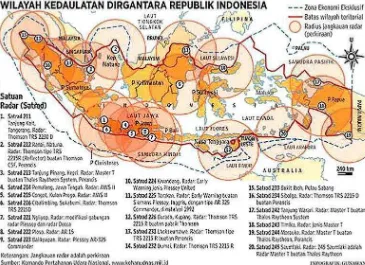
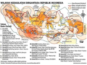
Figure 2. 2 Military Radar in Indonesia ...21
Figure 2. 3 Indonesian Archipelagic Sea Lanes ...23
Figure 3. 1 . Singapore Economic Growth ...37
Figure 3. 2 Singapore GDP in last decade ...38
Figure 4. 1. . The Area of Flight Information Region between Indonesia and Singapore ...48
Figure 4. 2 . The Area of Flight Information Region between Indonesia and Singapore ...49
Figure 4. 3. The Area of Flight Information Region between Indonesia and Singapore ...52
CHAPTER I
INTRODUCTION
A. BACKGROUND
Every state in this world has a right to rule its own territory, whether it is in land, sea, or airspace. It is supported by UN Charter which states the principle of sovereign equality among its member. It means that every UN member has a right to enforce its authority through all its territory. Based on the premises above, Indonesia certainly has a right to authorize its own territory fully without intervention from any party.
Unfortunately, in a part of Indonesia, there is an area which belongs to Indonesia but controlled by other state. An airspace area which lies along Natuna and Riau Islands is controlled by Singapore. It has become the control of Singapore since 1946.
In international aviation terminology, there is an agreement called Flight Information Region (FIR). Flight Information Region is an airspace region which provides flight information and Alerting Service (ALRS). Every airspace in this world is controlled by certain FIR. Some small states or neighbor state are controlled in one FIR. FIR itself is agreed by two neighbor states and acknowledged by International Civil Aviation Organization.
regulated under British occupation. Indonesia agreed to give away Riau and Natuna Islands air control to Singapore under British occupation.
This FIR itself was re-negotiated under the new independent government of Singapore and Indonesia in 19731. Singapore was afraid of black flight above that area could threat the security of Singapore. Thus, Singapore had an intention to control that area to prevent black flights go to its area.
Indonesia agreed with that agreement because at that time sea among Riau and Natuna islands still as international seas. But after UNCLOS 1982 it became a problem. As the archipelagic state concept was accepted by UN, sea among Riau and Natuna islands became Indonesia territory. Of course it was a good chance for Indonesia getting the sea among that area. However, it became a bad decision letting other state rule inside Indonesia territory.
Some negotiations about FIR were conducted after UNCLOS 1982. But again, lack of radar technology and the unavailability of independent air traffic control institution became the main reason letting Singapore to control that area. Through some RANs2, Indonesia tried to take over airspace control over Riau and Natuna Islands to integrate the authority of Indonesia. Unfortunately, Indonesia always failed to take over that area to Indonesia’s control by RAN or ICAO3 negotiation.
In brief, Indonesia has territory in Riau and Natuna Islands but never control it. Indonesia has an authorization on this area but never authorizing in this area. Airplane which want to
1
MiftachunNiam, Muh; Flight Information region (FIR) Diatas Kepulauan Riau;Solo;Universitas Slame tRiyadi; 2011.
2
Regional Air Navigation.
3
take off from airport around Riau and Natuna Islands has to wait the clearance from ATC in Singapore. It makes bureaucracy become longer in transportation governance.
Although according to ICAO, FIR is not breaking the authorization of a state, but
Indonesia still can feel the ‘indirect’ effect of FIR itself. There are so many black flights fly
in this area. Even the losing of MH370 could not be tracked by Indonesian radar although it passed over Indonesian sky. It was because MH 30 passed over the area which were controlled by Singapore ATC. Indonesia could not speak too much although some Air Force officers claimed that Indonesian radar caught the flight path of MH 370. It was because Indonesia did not have the authorization to control that area.
The condition goes worse since, in South East Asia, the nationality in each state is strong. Unlike, European people who claim that they are European citizens, the nationality in South East Asia is based on nation, not region. If it is noticed by Indonesian citizens, they will demand to get back the border to Indonesia.
Although, the government claimed that they already re-claimed this area to Indonesia’s authority, it needs 10 years to get this region back to Indonesian authority.
B. Research Question
Based on those backgrounds and problems that are found above, thus to ease solving the problems and as a guide for advance discussion, it can be concluded the research question as it follows:
Why Indonesia cannot take over Air Traffic Control in Riau and Natuna Islands from Singapore?
C. Theoretical Framework
For answering the question above, this thesis tries to use concept as a theoretical framework. The concepts will be used to answer the question above are Security concept in realism perspective and asymmetric warfare concept.
National Power
In international relations, there is a very popular concept, it is power. Power gives very big impact to a subject of international relations. Power can control over a mind and action to other men. It is undeniable that men always look for a power to achieve the goal. The source of power itself is various. There are some sources of power which can determine the result of power and those are tangible.
Unfortunately, if talking about nation, it is impossible to measure the power of a nation. Nation is non-empiric thing, nation is intangible, abstract. Nation cannot be observed directly. The only thing that can be done is by observing every person inside the nation itself. Nation uses human to do the activity.
become a bargaining power in international affairs. In his book, Politic Among Nations, Morgenthau made an analogy to describe the nation behavior. He said that every state action is like human action. Nation needs power to achieve its goal. Thus, Morgenthau developed some sources of power of a state that can measure the power activity of a nation. Those are geography, natural resources, industrial ability, military, population, national character, diplomacy quality, and government quality4.
In this case, this undergraduate thesis will use diplomacy quality factor and military factor. Diplomacy was derived from ancient Greek word diploun means to fold. It was called
diploun because at that time, the diplomats folded their official letter into two. In sum,
diplomacy is an activity which has an obligation to conduct a negotiation with other states and results to an arrangement or agreement. In this undergraduate thesis, diplomacy means any foreign political activity which is done from any level of governance, from the lowest level of government until the highest level of government.
Of course, diplomacy needs a good quality and good skills of negotiation to achieve the goal of a state. The process of negotiation itself also needs some bargaining power which gives the diplomat an opportunity to achieve the goal. The bargaining power itself is various. Military, technology, industry, economy, natural resources, population are some examples of aspects that can become bargaining power of a state.
Ligitan case. Thus, the quality of diplomacy become one of the main factors of national power.
While, military aspect itself is very important to a state. Military is a reflection of power of a state. A state needs military to defend and to sustain the existence. Military protects a state from any intervention whether symmetric or asymmetric, like terrorism. In certain condition, military is needed to keep the peace in this world.
In the term of national power, military can be divided into three main aspect. The first is technology. It is undeniable that military needs advanced technology, more advance technology that military of a state has, more powerful the military itself. Technology can be used in various aspects in military, like weaponry system, military aircraft, missile, weapon, tank, ship, battleship, and how those weaponry system can be integrated. In armament aspect, as example, how far the range of a military radar.
The second aspect is the quality of leadership in military. As example is the quality of military leadership of Napoleon Bonaparte. It is well-known that Napoleon Bonaparte was a good leader. How Napoleon managed his personnel, how Napoleon created strategy in a war, how he motivated his personnel.
The third aspect is the quantity and quality of military armament. Big amount of military personnel is also very important in a war. However, the big amount of military personnel itself does not give a guarantee, as example, in civil war in Somalia in 1992 when US Army ambushed the Bakara Market, about 70 personnel of US Army had to face 1000 Somalian rebellion. In the end of the ambush, about 20 personnel of US Army was KIA5 and more than
5
400 Somalian was dead. Another case is when 2012 Sukhoi SU-27 Indonesian Air Force defeated F-18 belong Australian RAF6 in a joint training. It gives the example how the quality of military armament, especially personnel and weaponry system, gives massive impact.
In this topic, the quality of diplomacy and military will be integrated to answer the research. Military, from those aspects mentioned above, can become a good bargaining power for diplomacy or international negotiation. Better military force can implicitly affect other state to be afraid. As example, technology in military can become a justification to take over other area. More specific example, state A can take over the control of an area in state B because of the reason of limited radar coverage.
National Interest
National interest is one of the most popular concept in international relations. Moregenthau said that the concept of interest is relating to power. A state always tries to chase power in inter-state interactions. It is undeniable that in inter-state relations, unintentionally, makes a state to use the power to control or at least influence other state to get its goal or needs. The needs of a state can be to defend the exoistence of the state itself, to gain the national power, and/or to broader the national power itslef.
Jack C Plano and Ray Olton stated that national interest is ―the fundamental objective and utimate determinant that guides the decision makers of a state in making foreign policy. The interest is typically a highly generalized conception of those elements that constitute the
state’s most vital needs. These include self preservation, independence, territorial integrity,
military, security, and economic well-being.”7
From those points that are mentioned above, it is said that independence and territorial integrity are important to maintain the national interest of a state. Independence is a condition
6
Royal Air Force
7
where a state is free from any form of control that is done by other state. If a state has its independence, the sovereignty will come along. As example, Indonesia finally got the independence in 1945 and after that, Indonesia was free to decide which way to go by its own way. It is proven by the foreign policy that has been done by Indonesia.
Next important aspect of national interest, according to Jack C. Plano is territorial integrity. Territory is one of the main requirement of a state in international politics to become a state. It is obvious that there are air, land, and sea territory, although some states do not have sea within their territory and it is important to integrate those territories to make them secure. To integrate the terriroty, of course good military is needed which secure all the territory of a state. As example, TNI tries to secure every inch of Indonesian territory from air, land, and sea and integrate them into one single command.
This territorial integrity faces a very serious obstacle. Above Riau and Natuna Islands, there is an area which is controlled by Singapore. This area belongs to Indonesia but is controlled by Singapore. In civil aviation, it is called FIR. FIR allows Singapore to control civil flights which pass through that area, although the flight is Indonesian domestic flight. Singapore also has a right to conduct military training over that area. This agreement was called MTA Agreement8 and was conducted during Soeharto' regime.
For Singapore, FIR and MTA Agreement are very important. Singapore realizes the limited space that it has. Different condition happens in economy. Singapore, as one of the richest state in the world has big income to spend in its national income and expenditure. In military, Singapore has various military equipment, including aircraft. Unfortunately, due to
8
the limited space, Singapore cannot use these military equipment in maximum condition. Thus, Singapore needs FIR and MTA to use its military equipment.
The next aspect is security. It is obvious that all states need security. Security, which derives from word secures means free from threat. The term threat itself is changing from traditional meaning, which only emphasizes on war and tangible conflict, to conventional meaning. Security, in general, is not seen as a condition of no war anymore but more than a condition where threat is not detected or in a simple word is a situation withouth any risk. The term and shape of risk is also developing. Threat can come from any aspect; from internal or external aspect, not only tangible object but also intangible object. What it seems not dangerous can be dangerous, what it seem powerless can become powerful.
Unfortunately, nowadays, security is a complex term. What it seems not dangerous can be dangerous as the development of technology. Few years ago, it was impossible to jam a radar and it was impossible to manipulate any data in flight information. Yet, it is easy to manipulate radar or flight data. As the example; the amount of stealth aircrafts are many in recent years. Those aircraft can be used to intelligent mission. This is a very serious threat to other state.
D. Hypothesis
Based on the background and analysis with theoretical framework above, we can make a hypothesis on the reason why Indonesia cannot take over the Air Traffic Control above Riau and Natuna Islands because first is historical and geographical factor. Second is because institution factor. Third is technological factor. And fourth is military factor
E. Research Method
Research method is to guide the researcher about how this research is done. This research is done by using qualitative method. While, the type of this research is analysis, which is to collect, analyze, and predict the phenomena regarding to the case. Of course the predictions are based on evidences and data that are collected.
Data collection of this research uses library research and secondary source which are coming from books, newspaper, journal, etc. The sources are relevant with the topic above and support each other.
F. Range of Research
Range of research is used to border the research in hope that the research will be specific focusing on certain points and minimize the useless point related to topic above. Range of research in this research focuses on the reason why Indonesia cannot take over the Air Traffic Control over Riau and Natuna Islands from Singapore since 1949.
G. Writing System
This writing will be divided into 5 (five) chapters, where each chapter will discuss detail things that are related to this topic to make the readers understand easily, which as it follows:
Chapter II will explain the Indonesian aviation. It will discuss the history of Indonesian aviation. This chapter will also explain about the process of identifying a threat in airspace by KOHANUDNAS, the process of intercepting and forcing down a black flight by TNI AU.
Chapter III will explain the general information of Singapore. The history of Singapore, the government of Singapore, how is the decision making process in Singapore, the dilemma of Singapore living in Malay Peninsula but being dominated by Chinese, the economy of Singapore, and the Singapore’s military and defense system. This chapter will lead the instruments that Singapore has to control this area.
Chapter IV will analyze the reason why Indonesia cannot overtake the ATC over Riau and Natuna Islands from Singapore. This chapter will seek for the problem from the previous chapters. There must be any security reason why former KASAU (Chief of Indonesia National Airforce), Air Chief Marshall (ret) Ida Bagus Putu Dunia and Air Chief Marshall (ret) Chappy Hakim put this issue on a surface.
CHAPTER II
INDONESIAN AVIATION
This chapter is going to discuss about aviation in Indonesia. From the history of Indonesian aviation from the beginning until recent day. This chapter will also discuss how KOHANUDNAS identify the flights that pass Indonesia, how KOHANUDNAS distinguish where is the allowed flight and black flight and if there is a black flight, how is the process of intercepting this flight by TNI AU, and the reasons why TNI AU places its fighters aircraft in Pekanbaru, Pontianak, Madiun, and Makassar.
A. Indonesian Aviation History
Talking about flying in the air, Indonesia has very long history of it. Even before Wright Brothers made their plane in 1903, Indonesian people already had a dream that people could be flying in the air. There are so many folktales that describe people can fly in Indonesia from Gatotkaca, the story of Ramayana, and other folktales. The other prove is the existence of Kraton Palace seal which is wings. This shows that Indonesian people already dreamt that people can fly long time ago.
The history of Indonesian aviation can be found in pre-independence era. Indonesia started it since it was occupied by Netherland in 1904, about one year after Wright Brother made their flight experiment in 1903. A Dutch engineer named Ir. Onnen made a plane from bamboo. Then he continued his experiment by making glider with the design of Octave Chanute.1
1
Next, in February, 19 1913, a Dutch pilot named J.W.E.R Hilger successfully piloted a Fokker in an exhibition in Surabaya. This was the first flight that occurred in Indonesia. The plane crashed but luckily the pilot survived2.
A year after the flying test in Surabaya, in May, 30 1914, Dutch government established an institution which had a job to test an European plane to be able to fly in tropic condition. This institution had an authority also to change the specification of a plane to be suitably used in Asia to strengthen the Dutch Airforce in Asia. As the time went by, this institution grew into an aero sport club for glider in Solo, Madiun, Bandung, and Palembang.
In 1923, Dutch government established an institution named Technische Dienst Luchtvaart Afdeling in Bandung. This was the first airplane manufacture in Indonesia. This institution was moved to Husein Sastranegara Airport (the previous name was Andir Airport) in 1924 to facilitate the research and make bomber airplanes to counter the Japanese Bomber plane. This facility also used native Indonesian as its employee.
In Bandung also, the first training plane was built. PW1 was the first single-engine plane that was made by Akhmad Taslim and Tosin with the assistance of Ir. M. V. Pattist and L. W. Walraven. PW 1 first flight was on September 1933. Next year, they built two more planes named PW2 and PW3. PW2 firstly flew in January 1934. PW2 was registered as PK-KKH. This airplane was the first Indonesian made double-engine airplane which could fly to Netherland although it was not piloted by Indonesian3.
In struggle to defend Indonesia’s Independence, airplanes were used to attack some Dutch Depot. In November 1945, Agustinus Adisutjipto established air force academy in Yogyakarta. Using ex Japanese airplane, this academy taught Indonesian pilots. Using ex
2
Ibid
3
Japanese planes also, Indonesian pilots tried to defend Indonesia Independence. Unfortunately, Adisutjipto with Abdurrachman Saleh were killed in Bantul, Yogyakarta after their plane was shot by Dutch when they brought medicines from India.
After Independence, Indonesia tried to establish a bigger airplane industry. In 1946, three Indonesian Air Force officers, wiwiek Soepono, Nurtanio Pringgoadisurjo, and, Sumarsono established an airplane workshop in Madiun. In this airplane workshop, they made a glider airplane named NWG-1. This airplane was meant to attract Indonesian people to join air force and as a preparation before going to India for training. They also made a plane called WEL-1 and registered as RI-X.4
Nurtanio was really a hero in airplane manufacture. As am Air Force officer, he invented so many planes during his era. In April 1954, he invented Si Kumbang, the first full-metal airplane in Indonesia. Four years later, he led a research group and made Belalang as the first training plane in Indonesia. Nurtanio also invented airplane industry in Indonesia, the bureau he led became IPTN (Now PT.DI). Unfortunately, Nurtanio died on a plane crash5.
During that era also, Indonesia still could not supervise the airspace area that Indonesia had. As a newly developing state, Indonesia still had a problem with infrastructure. It was been worse when there were so many rebellions in Indonesia. Indonesian government was busy to fight against those rebellions. The government, at that time, thought that it was not necessary yet
to buy a radar. There were so many infrastructures that became government’s attentions.
Whereas, the location of Indonesia is quite strategic.
4
Ibid
5
British colonial in Singapore, at that time wanted to control this area since Indonesia could not control this area. Indonesian Air Force was born on April 9 1946. Indonesian Air Force also only used the former Japanese armament. There was no radar that was left by Japan6.
Singapore has taken control of ATC above Riau and Natuna Islands since 1946. At that time, the air traffic in that area was quite massive. Unfortunately, Indonesia was not ready yet to control area above Indonesia itself. It became worse since the territory of Indonesia was changing due to some negotiation with Dutch. At that time, ICAO, as the international flight regulator commanded that that area was needed to be controlled. ICAO conducted the
negotiation between Indonesia’s representation and Singapore’s representation which was
represented by British Colony. This negotiation was meant to talk about which state had the authority to control this area. Unfortunately, Indonesia could not come due to defending the independence. Finally, this area was controlled by Singapore.
Riau and Natuna Islands was clear to be a part of Indonesia after 4 December 1949. At
the final negotiation in Netherland, it was clear that Indonesia’s territory was all territory ex
Dutch occupation. Since that time, Riau and Natuna Islands belonged to Indonesia.
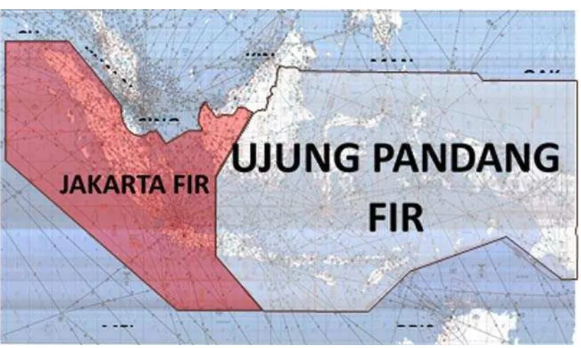
those airspaces. Air navigation was controlled by Transport Department. After 1964, air navigation was given to PT. Angkasa Pura. Unfortunately, At the first time it was established, PT. Angkasa Pura was not meant to control air navigation. Angkasa Pura was established to control the airports in Indonesia, not the navigation. Automatically, there was different SOP between Angkasa Pura in Jakarta as the central ATC in western side of Indonesia and Angkasa Pura in Makassar as the central ATC in eastern side of Indonesia. Indonesia established an independent ATC institution called LPPNPI9 or commonly known as Airnav Indonesia that was just established in 2013.
Airnav divided Indonesian airspace into two FIR sections. Jakarta FIR and Ujung Pandang FIR, continuing what Angkasa Pura did before. Jakarta FIR serves western Indonesia and Ujung Pandang FIR serves eastern Indonesia. Airnav Surabaya sector becomes the border between Jakarta FIR and Ujung Pandang FIR.
Figure 2. 1 Airnav Airspace Division
9
Source: http://www.airnavindonesia.co.id/id/page/about/type/airspace
B. Indonesian Airspace Defense
In airspace defense, Indonesia, especially TNI AU, counts on KOHANUDNAS to watch over Indonesian airspace. KOHANUDNAS was established in 1962. KOHANUDNAS has a duty to enforce the law and authority over Indonesian airspace. Using radar, KOHANUDNAS tries to watch every flight in Indonesia and try to prevent black flights come to Indonesia. About 80% work of TNI AU is held by KOHANUDNAS.
To ease the work of KOHANUDNAS, KOHANUDNAS divides Indonesian area into 4 sectors. The command sectors of KOHANUDNAS are located in Jakarta, Makassar, Medan, and Biak, while the acting command sector is located in Jakarta, near Halim Perdana Kusuma.
military radar in TNI AU cannot work for 24 hours. Military radars belong to KOHANUDNAS in each sector can only work for 18 hours a day. In 2017, TNI AU will upgrade those radars to be able to work 24 hours a day. While, Australia, which has smaller area, has satellite to watch all over Australia.
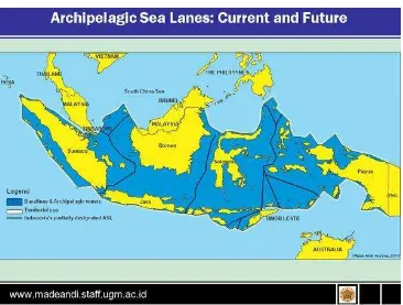
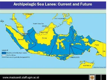
In fact, spectrum of threat that faces by KOHANUDNAS can come from various aspects. Some of them are satellite, solid matter in airspace, UAV,10 airborne, laser, missile or ICBM, black flight, low speed black flight, and one of the most dangerous is AWACS11 plane from another country like Boeing E-3 Sentry. AWACS plane is known to be able to jam radar on land. Actually, Indonesian airspace defense is so hard to be defended. Not only in lack of military radar, TNI AU must be aware any threat that comes from ALKI.12 As in UNCLOS 1982, that rules about archipelagic state, archipelagic states have an opportunity to determine the border from the most outside sea shore. As the biggest archipelagic state in the world, Indonesia needs to determine ALKI which will be assumed as international water. As in international water, any ship or plane which passes through ALKI does not need to ask permission to Indonesia.
This is the consequence that Indonesia has to face as the biggest archipelagic state. As people know that Indonesia is located between Asia and Australia continent. Any ship or plane that flies from Asia to Australia and vice versa has to passes through Indonesia. To ease the permission in Indonesia bureaucracy, any international ship or plane which flies from Asia to Australia or vice versa does not to ask permission to Indonesian government as long as it passes ALKI and it is not allowed to land or close in Indonesian seashore unless in a force majeur condition.
There are three slots of ALKIs all over Indonesia to connect Asian continent and Australia continent. The first ALKI lies along South China Sea, Sunda Strait, until Indian Ocean. The second ALKI lies along North of Sulawesi Sea until Indian Ocean. The third ALKI lies along North Maluku, Arafuru Sea, until Indian Ocean.
It is different with what happen in navy, KOHANUDNAS is the only institution which protects and watch over Indonesian airspace. If in navy or sea protection, there are at least 12 institutions which has the duty to watch over sea lane. Some examples of the institutions are Ministry of Sea and Fishery, Air and Water Police (POLAIRUD), TNI AL/Indonesian Navy, and Custom. It can be imagined how hard the work of KOHANUDNAS in watching Indonesian airspace with limited sources.
Based on the record and seeing the news, KOHANUDNAS recorded black flights pass through from the ALKI. The most shocking moment occurred in 2001 in Bawean Gulf, near the second ALKI. When US Navy held a military training above that area. It was disturbing that so many domestic flights that passed there. It was reported by civil pilots who passed there and was confirmed by ATC in Surabaya. There were 5 F/A-18 Hornets US Navy conducted military training there. US Navy claimed that they were in International Sea. Indeed, the carrier was in International Sea, but their fighters were above Bawean Gulf, whereas Bawean Gulf belongs to Indonesia and the term of condition of ALKI says that ALKI cannot become a military training area by any state.
KOHANUDNAS also made some notable identification and interception in defending Indonesian airspace. KOHANUDNAS forced down Pakistani civil airplane on 2012 in Makassar.
The process of aircraft identification in KOHANUDNAS is also very complex. If an unidentified aircraft is detected in military radar in one of KOHANUDNAS radar sector, the aircraft will be labeled as LASA U13. After that, the LASA U is reported to KOHANUDNAS main base by each sector. KOHANUDNAS main base has to check the report to Transportation Department whether Transport Department issued a clearance or not. After that,
13
KOHANUDNAS has to check to Foreign Affairs Ministry to check whether it is a diplomatic mission aircraft or not. After that, KOHANUDNAS will check the intelligent data whether it is dangerous or not. If there is no clearance which was issued by those institutions,
Actually, there are still so many lack that KOHANUDNAS has. Beside in military radar source, KOHANUDNAS still has problem with limited weapon sources. KOHANUDNAS also does not have its own interceptor squadron. KOHANUDNAS still asks the other fighter squadron to intercept any black flight which passes through Indonesian airspace territory. It is necessary that KOHANUDNAS needs its own interceptor squadron that can work fully 24 hours. KOHANUDNAS usually asks for help to the nearest squadron where the black flight happens. The TNI AU fighter squadrons are located in Pekanbaru, Madiun, and Makassar. KOHANUDNAS only relies on air to ground missile which are QW missile and Smart Hunter missile that is operated by PASKHAS AU.
which are very old. They are the early radar of KOHANUDNAS and can display the object in two dimension. While Master-T is very high technology radar which can display the object in three dimension and effective watch over 100.000 feet. Master-T is placed mostly at eastern side of Indonesia and in Riau.
C. Indonesian Air Defense Identification Zone
Air Defense Identification Zone or ADIZ is an airspace over a state in which the identification and control of civil aircraft is performed by the state to maintain national security. ADIZ may extend beyond a state territory to give a state some time to respond to hostile aircraft or possibly hostile aircraft. Although it extends beyond a state territory, ADIZ is not meant to broaden the state territory. ADIZ is also not ruled or written in ICAO or Chicago Convention, it is an initiative of a state to establish the imaginary line over airspace as a fence of a state against threat. ADIZ is the application of customary international law. In certain case, ADIZ in some states are overlapping each other. As example is ADIZ in East China Sea. There are several ADIZs in East China Sea belong to Japan, China, and South Korea. Although, it is not obligatory that every state have ADIZ.
ADIZ itself is different with Flight Information Region or FIR. If FIR is an agreement between two states and have a right to control the air traffic, ADIZ is not an agreement. ADIZ is a state policy to establish an imaginary identification line over its territory. As its name, an imaginary identification line, if there is a plane enter ADIZ, it is necessary that plane to be identified. So, ADIZ is used only for identifying of a plane, not for controlling the air traffic.
One thing that must be understood from ADIZ is that although the purpose of ADIZ is to
protect the state’s airspace area and it should extend over the border, the Air Force is not allowed
ADIZ. As example, there is a plane enters US ADIZ, US Air Force is not allowed to intercept the plane before it reaches the US borders. US Air Force is allowed to identify only and to seek for information whether the plane is dangerous for US or under terrorist control from any resources.
Indonesia also has ADIZ in the territory, beside limited airspace zone and restricted airspace zone. Unfortunately, Indonesian ADIZ is very small. As TNI AU and government have decided, ADIZ in Indonesia is determined only around Jawa Island until Lampung, and Bali Strait, not cover all Indonesian airspace. While, limited airspace zone is determined around Jakarta and restricted airspace zone is determined around Presidential Palace, Central Jakarta.
This is not a proportional ADIZ for Indonesia. As its name, ADIZ is determined to protect the airspace area of a state and it is acceptable that ADIZ is determined extending beyond the
state’s border as a preparation for intercept support, and in fact, states with ADIZ are usually
extend the state’s border. It means that if Indonesian area is placed from Sabang to Merauke, it is
necessary that ADIZ should have been determined extending some miles over Sabang and in Merauke by Indonesian government, especially by the Ministry of Defense.
CHAPTER III
SINGAPORE INFORMATION
This chapter will be discussing about Singapore. The general description about Singapore is; geography, demography, economy, government, economy, and military. Those aspects will lead to Singaporean decision-making process. This chapter will also discuss about agreements between Indonesia and Singapore in this case.
A. The History of Singapore
Long years ago, there was no man dreamed that this little state at the point of Malay peninsula would be very rich. This very small island, with less than 800 km2 in total area and fewer natural resources, no one would imagine that this state would be one of the richest states in the world, today. Long years ago, in 600 AD, Singapore Island just became the sea guard post and meeting point for traders under Sriwijaya Empire.
Jean E. Abshire in his book The History of Singapore even calls that Singapore was a poverty-stricken country with many people living together in a slum area along a river that doubles as a sewer.1 It reflects how poor Singapore at the beginning. Many people living that Jean E Abshire wrote refers to so many nations that lives in Singapore. From Chinese, Malay, Indian, and Arab.
Before belong to Sriwijayan Empire, Temasek, the previous name of Singapore, was known as the dangerous place for ships. There were so many orang laut, Malay word for sea people, sometimes attacked the ships. Orang laut was local people who lived among this area.
Orang laut usually attacked the trading ship by surrounding the ship with some numbers of small
1
boats. Sometimes, the trading ship could escape from orang laut by using winds, if the winds were favorable. By using the winds, the trading ship, which had bigger shape than the orang laut’s ship
could easily break through the small boats. In fact, most of them were caught by orang laut2. The king of Sriwijaya, made a cooperation with them and used them as the sea guard. This made sailing through this region was preferable for the maritime trade. This made this region was officially belonged to Sriwijaya. By controlling this region, the king of Sriwijaya forced the trading ships which across this area to stop in Sriwijayan Port. By stopping the ships to Sriwijayan Port, the ships were forced to pay some duties as an exchange to cross over the sea lane safely. These duties made income for Sriwijaya. There was no other way than passing this area since Sriwijaya controlled this sea lane from the north side of Malay Peninsula by using orang laut3.
Sriwijaya monopolized this trading route and became prosperous until Sriwijayan leader was kidnapped by Chinese Empire. It was assumed that Sriwijayan leader died in captivity. And for the next century, Tamil trading company from southern India dominated this region although the domination of Tamil trading company was still weaker than Sriwijayan Empire’s control. However, it was the turn back of Sriwijayan control under this region.
After 1000 AD, the influence of Sriwijayan Empire was slowly gone and it turned into the Ancient Singapore from 1200 AD. According to The History of Singapore, there was a prince named Sang Nila Utama, the Rajah Palembang tried to find a new occupation. First he went to Bintan, an island which is located southeast of Singapore. Sang Nila Utama made the new city in Bintan. One day, he landed on Temasek to go hunting. He was disappointed because there were only few animals in this island. Suddenly, he saw a very big animal appeared then disappeared. His minister said that the animal had similarity appearance of an ancient lion. Sang Nila Utama
2
E. Abshire, Jean. The History of Singapore. Santa Barbara: Greenwood,2011.
3
was interested to make a new colony in this island and called this island Singapura, the lion town. This was the story how Singapore got its name. Then, Sang Nila Utama built his new kingdom here, in a place that today is known as Fort Canning Hill4.
It is noted that there were several kingdoms that rules Singapore after Sang Nila Utama’s empire. After the Ancient Singapore was conquered by second invasion of Majapahit, there was a new empire just about north of Singapura, Kingdom Malaka, from about 1398 until 1511. Although, it is said before that Majapahit conquered this region, but the distance between this region and the capital kingdom made Majapahit hardly controlled this region. This situation was used by Kingdom of Malaka to establish a new colony in Singapore. After Kingdom of Malaka, there was Kingdom of Johor ruled this region from 1511 until 1699. After this kingdom, there was Kingdom of Johor-Riau and Bugis from 1699 until 1818. This kingdom was the successor of Kingdom of Johor. It is also noted that from these two kingdoms era, Europeans started to come to this region as an expansion effort. Although there were so many kingdoms that ever ruled Singapore, those kingdoms had one similarity, those kingdoms used Singapore as a port5.
After those kingdoms, there was a colonialization era. British used Singapore as its colony and made this region a port to control East India Company (EIC) trade. British placed its fleets in
Singapore to protect the trading ship from pirates as EIC’s trading ship tried to sail from Indonesia
to Calcutta in India as the main base of EIC. EIC trading ship was in Indonesia to get spices and to sell it in Europe. It was a trend that a kingdom, like British, made a colonialization overseas.
Before British colonialization made Singapore as a colony, British colonialization that was led by Sir Thomas Stamford Raffles already occupied Bengkulu. Bengkulu was chosen by Raffles
4
Ibid
5
because Bengkulu was near to spices plantation and quite far from Jakarta (Batavia) as the central Dutch colonialization. He thought that Bengkulu was quite safe from Dutch6.
Unfortunately, Bengkulu also quite far from the main trading route also. Then, Raffles thought of making new colonialization. He saw that making a new colonialization in Penang had a good opportunity. He tried to secure the trading route with China. He believed if peace could be made with Aceh Empire, across Penang, this trading route would be very secure and strategic. Unfortunately, he suddenly thought that Penang was located too north from the critical main route that was located at the point of Malaka Peninsula. Then, he tried to get Singapore as a new colonialization, the most strategic place in the region7.
As the time went by, Singapore became very important port for EIC. At the beginning, Singapore was under control of EIC colony in Bengkulu. Knowing that this region was very strategic for EIC, it shifted the status of Singapore from under control of EIC in Bengkulu to under control of main base EIC in Calcutta. EIC took this action because EIC realized that this region was very important to protect trading route between EIC and Chinese trader. And as the time went by, EIC united three EIC colonies, Penang, Melaka, and Singapore, into one administrative unit, with the headquarters in Penang. Again, the status shifted to strait settlement.
suppresses political opposition. While, in economy, Singapore tried to become an industrialization state. Singapore tried to produce and replace some goods that were imported before like textiles8.
B. Singaporean Government and Foreign Policy
Singapore is a republic parliament state. Singapore head of state is president and the head of government is led by Prime Minister. Prime Minister is appointed by the president from majority party. While, the cabinet is elected by the president on the advice of Prime Minister. The parliament consists of 84 elected member.
In foreign policy, Singapore is very unique state. It has small area but very rich. The power of money gives Singapore ability to develop its national power. The economy of Singapore is very stable also that what makes Singapore have unlimited budget. It is also supported that Singapore is one of the commonwealth states that makes Singapore can get help from other commonwealth states. In short, the national power of Singapore reaches beyond its area.
Singapore’s major party People Action Party (PAP), dominates political hegemony in Singapore. PAP as the government party needs to maintain political hegemony in this state. How strong PAP in Singapore can be seen from the assumption that the government of Singapore is the reflection of PAP and vice versa. Everything that PAP states is the reflection of the government of Singapore, the policy from government is the policy of PAP. This was acknowledge in PAP’s journal Petir in 1982
The PAP is, of course, a registered political association. But it is more than that. It is not concerned just with winning elections. It is not concerned with political posturing and playing to the gallery. It is concerned with our nation, with our people, with our future and our survival…
The PAP is the vital nerve center of the entire nation… Without the PAP, there will be no
8
Singapore as we know it today, as the Secretary General Comrade Lee Kuan Yew has stated, ‘I
make no apologies that the PAP is the government and the government is the PAP.9
The government makes the citizens of Singapore think that PAP has very vital role in establishing and developing Singapore. As Minister of Information and the Arts George Yeo said to PAP activist in 1993, Without PAP, we would not have been able to complete the last lap. Without PAP, we will not be able to run the next lap.10 it reflects the important role of PAP.
The interesting topic talking about PAP’s hegemony is how PAP maintain its ideological
hegemony in Singapore. This action is facilitated by the state control of information and knowledge dissemination channels such as media and education system. There is no media which can easily criticize the government. The potential of foreign newspapers and journal publication which criticize the condition of Singapore or the government is restrained by the government. This action is legalized by the amendment of Newspaper and Printing Presses Act in 1986 which states that the government has a right to renew the annual license of Newspapers and Press under the stringent condition. Based on that act, there is no way for oppositions to criticize the government or to publicize their views.
In school, consent is controlled through moral education by creating curriculum which
suitable with ‘Asian values’ to student. The ‘Asian values’ is influenced by Confucian orientation.
The values include the unquestioning reverence for higher authorities, and respect for scholars and the state. This makes the Singaporeans are easy to be ruled by the government.
PAP relies on the majority status of Chinese in Singapore. Some policies were made to increase the numerical majority status of Chinese. Lee Kuan Yew stated that the decreasing of
9
Petir, Editorial, Deccember 1982: 3 as quoted in Rahim, Lily Zubaidah. "The Singapore dilemma: The
political and economic marginality of the Malay community." (1998) p. 30.
10
Chinese birth rate was becoming one of the three main national problems. In 1989, there were already 4,707 families that emigrated from Hong Kong to Singapore.11
PAP believes that Malay are very lazy, indiscipline, lack of motivation, and apathy. Malay tends to blame the state about their life and rely on state subsidy. It is not reflecting the ‘Asian
values’ which is applied by the government. The government promotes that every person is
responsible for his/her own life and every Singaporean has to be competitive. Lee Kuan Yew said that the egalitarian society which empathizes on state subsidy would not make the economic grow well. 12
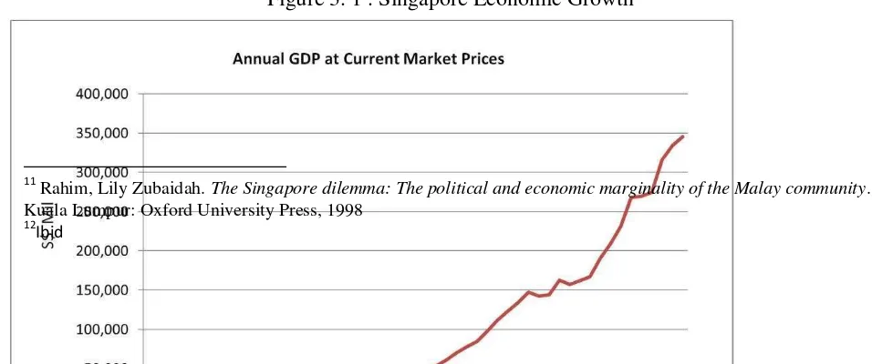
Those unfair policies are justified by the massive economic growth of Singapore. The economic growth of Singapore is very impressive. Singapore is considered as the developed states from the economic growth.
Figure 3. 1 . Singapore Economic Growth
11
Rahim, Lily Zubaidah. The Singapore dilemma: The political and economic marginality of the Malay community. Kuala Lumpur: Oxford University Press, 1998
12
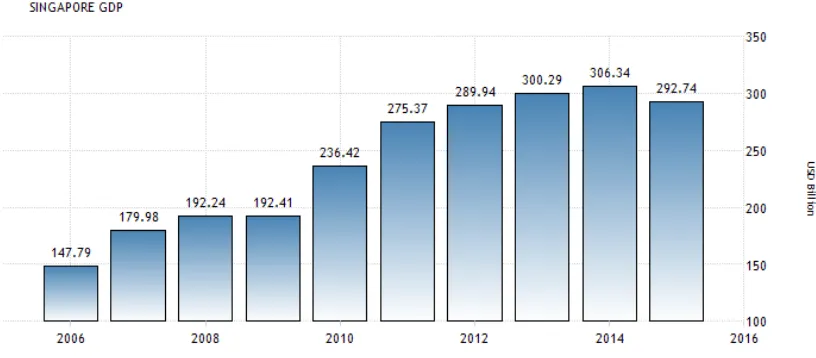
Figure 3. 2 Singapore GDP in last decade
In foreign policy, Singapore tries to maintain regional stability to develop the economics. Singapore realizes that security is the main aspects to maintain the economic growth. In other hand, Singapore keeps aware with its neighbor like Malaysia and Indonesia. The government gives more attention to the military. This action is shown when the government spends the National Budget and Expenditure to buy the latest military equipment.
For a quarter of century, the relations between Indonesia and Singapore were conducted in a relative stable situation because of the close relations between former President of Indonesia Soeharto and former Prime Minister of Singapore Lee Kuan Yew. During President Soeharto era, there were some of important agreements between Indonesia and Singapore. Unfortunately, this stable condition was not long because of the downfall of Soeharto in May 1998. His successor, president Habibie did not have a close relations with Singapore. Even president Habibie had a personal grudge against Prime Minister Lee Kuan Yew for casting doubt on the credential of vice-presidential office when president Habibie was a vice-president. Fortunately, this situation did not last long, President Habibie only lasted for a year. The next president of Indonesia, Abdurrahman
Wahid acknowledged the important of Singapore’s role in Indonesia during economic recovery
after monetary crisis and offered a close friendship to Singapore.
C. Singapore’s Military System
Singapore is considered as one of the strongest state in military aspects in Southeast Asia region. This is because Singapore spends a lot of money to buy the latest military equipment. Singapore spends overall 4% of National Budget and Expenditure to Military aspects, and in 2015, it increased to 5,7% of National Budget. Singapore also requires the citizens to join national military service for two years either in Singapore Armed Force (SAF), Singapore Police National Force (SPNF), or Singapore Civil Defense Force (SCDF). The Singaporean will be selected to join one of them based on physical and medical fitness. This policy is applied by the government since the population of Singapore is not quite big.13
13
SAF is led by Chief of Army who has rank as Major General who is responsible under Chief of Defense Force as the highest position in Singapore Army. SAF is reinforced by 72.000 active frontline personnel and more than 900,000 reserve personnel who are divided into three task force, HQ Island Defense, HQ Joint Task Force, and HQ Special Operations Task Force; and six division. The personnel of SAF is also divided with various specialty like infantry, guards, command, armor, artillery, combat engineers, signals and command system, army intelligence, army medical, maintenance and engineering support, transport, supply, and military police. SAF is also equipped with so many latest weapon which support the soldiers to do their duty. SAF is supported by various kinds of tanks from main battle tank like Leopard-2A4, Bionix II in infantry fighting vehicle, M113A2 Ultra IFV in armored personnel carrier, SM-1 Launched Bridge to ease the movement of units of soldiers, until Firefinder mobile radar.14
In navy, there is Royal Singapore Navy (RSN) which is led by Rear-Admiral, to secure the naval area of Singapore. As informed in its official website, RSN is equipped with the latest technology in region. RSN has frigate class ship, victory-class missile corvette to prevent airstrike and submarine, patrol vessel, Minecountermeasure vessel to sweep the sea mines, Large Ships Tank to move or transport the tanks and helicopters, submarine support vessel to assist the submarine, and Littoral Mission Vessel as warship. Based on the official website of RSN, it is stated that the frigate class ship of RSN is equipped with stealth mode which means it cannot be detected by other ship radar. RSN also has Challenger-Class submarine and Archer-Class submarine, missiles like harpoon missile, torpedo, and cannon. RSN also has UAV, maritime patrol aircraft and naval helicopter with torpedo to attack submarine.15
14
https://www.mindef.gov.sg/army
15
In Airforce, Singapore is one of the strongest Airforce in region. In its official website, RSAF, which is led by Major Geneal, has fighter aircrafts, F-16D Block 52+ and F-15 SG from US. Those kinds of fighters are multirole fighter which means can be operated to intercept other aircraft and to give air support for ground personnel. Although Singapore does not have Air Superiority Aircraft and Air-To-Ground Aircraft like Indonesia with its Sukhoi Su-30 Mk and EMB-314 Super Tucano, but F-16D and F-15 SG are enough to protect Singapore completely. Singapore also has AH-64D Apache Longbow Helicopter to give ground support. Singapore is also known as the operator of KC-135 Stratotanker, an Air-Refuel Aircraft to support the aircraft. This KC-135 Stratotanker is very useful in combat area. This allows RSAF to take off with fully loaded of weapon, cruise to combat area, and do dogfight or give ground support without landing to the nearest airbase.16
With its strong armaments, RSAF faces a very serious problem. Singapore does not have a sufficient area for its Airforce. The fighters will face the border before it reaches the minimum altitude. As example, from Tengah Airbase, F-16 will face the border less than 5 minutes after taking off. The area of Singapore also does not meet the requirement to conduct an Airforce exercise. From Tengah Airbase, F-16D only needs less than two minutes from take off to the border. It means that F-16D will reach the border before it reaches the minimum altitude to conduct military exercise. If it reaches the minimum altitude, the pilot faces another problem because the pilot needs to turn avoiding the border also. RSAF also has a problem where RSAF can test its weaponry system like SAM and AIM-9 Sidewinder.
The Singaporean Army, SAF, RSN, RSAF, also conducts some joint military exercise with its neighbor and its ally. As the impact of FPDA, Singapore joins in joint military training
16
annually with other FPDA members. Singapore also conducts a joint military training with Indonesia. The latest joint military training with Indonesia was held in 2015. This gives benefit to Singapore since Singapore does not have a wide area to conduct military exercise with a big scale. Big scale means Singapore cannot test all of its military equipment together in same time. As example, Singapore needs a swamp area or big river to test its SM-1 Launched Bridge.
Beside the Joint Military Exercises, Singapore’s Army also takes a part in some of military
operation and humanitarian operation that was conducted by UN and FPDA. SAF took a part in Peacekeeping Force in East Timor and Iraq. The army also took a part aiding some catastrophe victims like in Sumatera earthquake in 2005. It is important as a member of UN to take a part in any UN mission.
In relations with Indonesia, Singapore has an agreement with the government of Indonesia to use some of its area to conduct military exercise. The first agreement was called Military Training Area in 1995. Indonesia and Singapore had agreed that RSAF had a right to conduct military exercise upon Indonesia area. This agreement was expired in 2001. Then, in 2007, Indonesia and Singapore made a defense agreement called Defense Cooperation Agreement. This agreement, beside renewed the MTA, also explained in which area RSAF could conduct a military exercise and in which area RSN could test the weaponry system. Those agreements will be discussed in chapter IV.
CHAPTER IV
THE REASONS SINGAPORE TAKING OVER AIR TRAFFIC CONTROL
ABOVE RIAU AND NATUNA ISLANDS FROM INDONESIA
This chapter will be discussing the reason why Indonesia cannot take over the ATC in Riau and Natuna Islands from Singapore. The analyses will consist of geography factor, technology factor, military factor, and other factor that are relating each other.
A. History and Geographical Factor
As the impact of the broad area of Indonesia, Indonesia needed a very good technology to cover all of the space in Indonesia. Unfortunately, due to the lack fund post-independence era, Indonesia could not have it. Indonesia thought that there were other important problems than that. At the first meeting that was held by International Civil Aviation Organization (ICAO) in 1946. ICAO thought that it would be necessary to conduct a professional ATC in Malay strait due to the numbers of flight that passed through Malay strait. ICAO invited Indonesia to join the meeting with British colonial in Singapore. Unfortunately, Indonesia could not send a representative because Indonesia still struggled for its independence. Thus, ICAO gave the ATC in Malay strait to Singapura or officially to British colonial.
unstable. Even Sumatera, an islands where this dispute happens, did not include as Indonesian border because of Renville Agreement.
Post- independence, Indonesia tried to secure its archipelago whether in sea or on air. Indonesia made some agreements with Malaysia and Singapore. Singapore tried to make a proposal to Indonesia to secure the ATC around Mlalay strait. Through Regional Air Service I (RAN I), Singapore proposed it to Indonesia. Indonesia agreed so Indonesia did not have to spend more efforts to secure this area. Indonesia still got advantage on Regional Air Service Charge (RANS Charge), a price for airlines for passing this area.
Indonesia also made an agreement with Malaysia called Hukum Rejim Negara
Nusantara in early 1982. This agreement allowed Malaysia to connect Western Malaysia and
Eastern Malaysia over Natuna Islands without any charge. And in return, Malaysia acknowledged this region to Indonesia.
In late 1982, UNCLOS about archipelagic state was signed by UN. This allowed all archipelagic states to secure their naval territory. This gave an advantage to Indonesia because Indonesian border was determined from the most outside Indonesian sea shores. All sea inside the border was considered as Indonesian area although the sea was located more than 12 mile from beach. Indonesia also did not have to make any agreement with neighbor state to secure its area.
qualification to conduct FIR over Riau and Natuna Islands. Indonesia did not have any sufficient technology and independent institution.
The conflict between Indonesia and Singapore about FIR continued for many years. Indonesia proposed a working paper on flight plan over Natuna Islands to ICAO. Unfortunately, Singapore also proposed a counter paper to ICAO. Later, ICAO gave this problem to be solved by Indonesia and Singapore. At the end, Indonesia and Singapore made an agreement called RAN II that will be discussed in institutional factor.
B. Institutional Factor
At that time, Indonesia did not have an independent institution to control and maintain its ATC. Indonesian government still relied on Angkasa Pura, an institution which responsible for airport management in Indonesia as explained in Chapter II. Angkasa Pura did not have qualification for managing ATC in Indonesia. Also, Angkasa Pura had so many task to manage the Indonesian airports. As the result, Indonesian Air Traffic System management was not reliable to control the Malay strait. It became worse, the diplomatic position of Indonesia became worse since Indonesia did not have a good civil radar in Soekarno Hatta airport to control Air Traffic System in Malay strait. Thus, Indonesia had to give the Air Traffic Control in ABC sector or above Riau and Natuna Islands to Singapore.
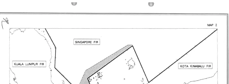
need to spend more money to build a sufficient infrastructure to manage this area. Indonesia even got more money because of Regional Air Service (RANS Charge). RANS Charge is a charge that an airline has to pay as a return for using and passing through a state territory, in this case is Indonesian territory. RANS Charge over ABC area was collected by CAAS1 and later will be given to Indonesian government through Department of Transportation of Indonesia.
1
Figure 4. 1. . The Area of Flight Information Region between Indonesia and Singapore
Source: Agreement Between The Government of Indonesia and The Government Of Singapore on The
Realignment of Singapore Flight Information Region and Jakarta Flight Information Region 1995.
Source: Agreement Between The Government of Indonesia and The Government Of Singapore on The
Realignment of Singapore Flight Information Region and Jakarta Flight Information Region 1995
The taking over of ATC from Indonesia to Singapura continued for over 50 years. Indonesia delegated Singapore to conduct the Air Traffic Control management to Singapore. This allowed Singapore to control all flights which pass this ATC. Every flight from Batam and Riau needs to ask permission to take off to Changi Air Traffic Control.
C. Technological Factor
solve this problem yet and continued to delegate the management of ATC in ABC sector to Singapore.
Technology became problem of Indonesia for some years. Civilian and military radars in Indonesia were left behind compared to other states in South-East Asia. Radar in Soekarno-Hatta International Airport, as the main gate for entering Indonesian territory, in some occasion was off due to the lack of electricity supply. In fact, the radar in Soekarno-Hatta International Airport had to guide so many planes that cross over the western sector of ATC in Indonesia in cruise mode. Based on the data, it was noted since 2010 there were seven accidents of power failure that made the radar in Soekarno-Hatta International Airport stopped working. The latest of power failure that happened in Soekarno-Hatta International Airport was in 2012. Same problems also happened in military radars. As explained in chapter II, it is obvious that military radar cannot oversee Indonesia fully 24 hours a day.
D. Military Factor
The ATC control of Singapore in Indonesia also makes Singapore get an ‘extra
territory’. As a small state, Singapore’s area is only 719,1 km2
. This limited area makes it is very hard to fly a fighter jet as explained in chapter III. Singapore, based on the agreement, has a right to control the air traffic until Natuna Islands near South China Sea.
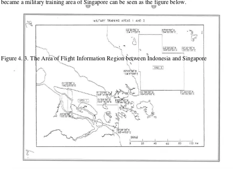
allowed Singapore to conduct its military exercise in Indonesian area. The area that usually became a military training area of Singapore can be seen as the figure below.
Figure 4. 3. The Area of Flight Information Region between Indonesia and Singapore
Source : Agreement Between The Government Of The Republic Of Indonesia And The Government of
The Republic of Singapore On Military Training In Areas 1 And 2 1995
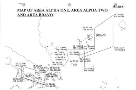
Figure 4. 4. Map of Area Alpha One, Alpha Two, and Bravo Area
Source: Agreement Between The Government of The Republic of Indonesia And The Government of