Remote Sensing Application and Spatial Database Design for
Sustainable Management of Coral Reefs in
Banda Island, South Maluku, Indonesia
Mr. Jose Mari Balines Gonzales
P36500004/MIT
Graduate Program
Bogor Agricultural University
Indonesia
ABSTRACT
Spatial databases are essential tools for preserving potential marine genetic resources. Banda Island, the study area for this project, is rich with marine biodiversity that can be easily exploited. A spatial database was designed for Banda Island in order to locate existing selected marine species among its rich coral reefs.
Two LANDSAT-7 ETM satellite images of the study area were processed to apply the Bottom Feature Index and perform ISOclass unsupe~ised classification. The images were then mosaicked to create a classified image showing the entire archipelago of Banda Island. The result was a raster image with classified features deviating relatively less from actual measurements of area in Banda Island.
A vector data of the study area was created from a topographic map and was used to create a geographic information system (GIs). The GIs was capable of helping users locate existing coral, algae and seagrass species on Banda Island's coral reefs and specifying area measurements. Using a software extension, the Banda ~slands GIs was made available through local network. A Web site was also created containing pertinent information on the marine ecosystem, socio-economic, climatic conditions and geography of Banda Island.
DECLARATION LETTER
I, Mr. Jose Mari Balines Gonzales, hereby declare that the thesis title:
Remote Sensing Application and Spatial Database Design for Sustainable Management of Coral Reefs in
Banda Island, South Maluku, Indonesia
contains correct results from my own work, and that it have not been published ever before. All data sources and information used factual and clear methods in this project, and has been examined for its factualness.
Remote Sensing Application and Spatial Database Design for
Sustainable Management of Coral Reefs in
Banda Island, South Maluku, Indonesia
B y :
Mr. Jose Mari Balines Gonzales
P36500004MT
A Thesis Submitted to the
Graduate School of Bogor Agricultural University, Indonesia In fulfillment of the requirements for the degree of
Master of Science in Information Technology for Natural Resources Management
Graduate Program
Thesis Title Remote Sensing Application and Spatial Database Design For Sustainable Management of Coral Reefs in Banda Island, South Maluku, Indonesia
Student Name Mr. Jose Mari Bdines Gonzales
Student ID P36500004
Study Program Master of Science in Information Technology for Natural Resources Management
This thesis proposal is approved by the Advisory Board
Dr. Ir. Vincentius P. Siregar Supervisor
Dr. Ir. ~uda'ng B. Seminar Co-supervisor
Head of the Study Program
q&..-
Dr. Ir. Handoko, M.Sc
AUTOBIOGRAPHY
The author, Mr. Jose Mari Balines Gonzales, was born on June 7, 1970 in
Sampaloc, Metro Manila, Philippines. He is the first of four children of Mr. Alfredo A.
Gonzales (deceased, February 2000) and Mrs. Vilma Balines Fountain (currently married to Mr. Quentain Dale Fountain).
His early five years of childhood were spent in Guam, USA- an American island
in the Polynesia. It would be the marine environment in Guam that would spark his
interest in Biology and the beaches. However, his basic education and college degree
were taken and earned hack in Manila. He was an active participant in public speaking
and drawing competitions during elementary, earning him his first set of awards,
including the school's institutional award Mananalzimpati ng Taon (Public Speaker of the Year) in 1982 at Julian Felipe Elementary School, Cavite City, Cavite.
In highschool, San Sebastian College-Recolletos (an exclusive school for boys),
he ranked among the class' top ten until in second year he was permanently disqualified
for voluntarily taking the responsibility for a supposed misconduct that another member
of the class did. His action not only saved the entire class from a gross penalty, but also
gained their respect. At this time, he was a good friend and an avid reader and viewer of
science-oriented books and TV programs. It would be through this exposure that he
would decide to be a Filipino Geneticist.
He took up and earned a degree of Bachelor of Science in Biology at De La Salle
University - Dasmariiias, Dasmariiias, Cavite. He was an active managing editor, later,
science editor, of the university's newspaper, Heruldo Filipino. It was during his first year when he founded, together with close friends, the science organization FEDISFRON
in the university and became its first elected president. Liiter, he was also elected as
president for the entire graduating class of the university. The school awarded him the
institutional award for science, Science Awardee, for 1990.
At the age of 20, he was invited to be a full-time faculty in the Department of
Natural Sciences in his ulma matter until 1993. He then resigned, and devoted three years of his life as a full time minister of Jehovah's Witnesses- a voluntary work helping
De La Salle University-Manila, and taught Genetics, Ecology and General Biology until
2000. Eventually, he qualified for a SEAMEO-BIOTROP scholarship for the MSc in IT
for Natural Resources Management programme hosted by the Institut Pertanian Bogor
This project would not have been possible if not through the kind assistance and technical support of several individuals and organizations. I would, therefore, like to take this opportunity to extend my sincerest appreciation to the following:
Foremost, I would like to thank the Sovereign God, Jehovah, through whom I have dedicated my life to, for constantly guiding me through the opportunities that opens to me. I can never repay the underserved-kindness He had shown me throughout my stay here in Indonesia, and will never be capable of doing so. However, I can only show my extreme gratitude by living up to my dedication to Him.
I am indebted to my supervisor, Dr. Ir. Vincentius P. Siregar, and co-supervisor, Dr. IT. Kudang B. Seminar, for sharing their valuable expertise and scrupulous guidance to complete this project. Time had truly been a constraint on this work, yet through their supervision this project had turned out to be more than satisfactory. They have shown me remarkable patience and understanding worthy of mentors!
This project is an offshoot from a major project currently being worked on by the Coastal Regions and Small Islands Unit under the Regional Office for Science and Technology for Southeast Asia of UNESCO. It is through the initiative and support of Dr. Stefano Fazi, former head of the unit (2001), and guidance of Ms. Ina Punvadi that I was able to gather and process the data essential to the completion of the Banda Island spatial database. Thank you very much, Dr. Fazi and Ina.
The opportunity to pursue and complete this MSc. in Information Technology for Natural Resource Management (MIT) program was opened to me by Dr. Florencia Claveria (Biology Department, De La Salle University-Manila). I am very grateful for her underserved-kindness and assistance, and for setting a very remarkable example of what a true La Sallian scientist and teacher should be- always in pursuit of excellence!
I am also grateful to SEAMEO-BIOTROP for the financial assistance that has been extended to me throughout the course of my study here in Indonesia, and for the accommodations and facilities.
Heartfelt appreciation is also extended to Dr. Ir. Handoko, Director of the MIT program, for accepting me in this program and for providing technical and academic assistance through Mrs. Wahyu Sri Harini, program secretary, and Ms. Dedek Fanny Siregar, assistant to the program secretary.
My sincerest thanks to all my professors and lecturers, especially, Mr. Muhammad Helmi and Mr. Eddi Nugroho who both never failed to extend a helping hand to all the technical help and guidance I needed in satellite image processing.
I would also like to thank H. Iding Bahrudin (Alm.) and Hj. Djuarsih for bringing into this world the greatest Indonesian brother I could ever have, Mas Erlan Suherlan. I can never express my sincerest gratitude to Erlan for showing me how great the food, music, culture and the people of Indonesia are- the Sundanese way! I am now 10% Sundanese. I truly appreciate the time he had given me to relieve me of homesickness, and for his family who took me in as its eleventh child. I will always cherish the PAD1 rock band, even though the Sundanese song
I would not only l i k e to thank my mom, Mrs. Vilma Balines Fountain, for her uncompromising love, sacrifice and support she had given me throughout my thirty-two years of life and stay here Indonesia, but would like to dedicate this accomplishment to her, too. Thank you for keeping the Vil~na Balines Foundation open to me. The same goes to my brother, James, and sisters, Jannete and Diane, who all kept the family barfire ablaze.
Lastly, I would like to thank my classmates, Mr. I. Hashim (Malaysia), Mr. P. Doydee (Thailand) and Ms. M. Aung (Myanmar), for the two years of companionship and friendly "quarrels" we had; to my former seniors who helped me out with my first year in the program, Dewi, Agung, Halili, Palm, Tint Khaing and Nani; and the MIT program personnel for the hilarious company, security and technical assistance, Pak Harry, Pak Iwan, Pak Arman, Pak Hasan, Pak Zein, Mas Andri, Mas Mulyadi and Pak Zaenudin.
CONTENTS
Page
Abstract
...
.i. .
Declaration Letter..
...
.11...
Approval Sheet
...
111Autobiography..
...
ivAcknowledgement..
...
.vi...
Contents..
...
.v111List of Figures..
...
xList of Tables..
...
xi ..
List of Appendices.....
.XII1. INTRODUCTION
1.1 Background of The Problem..
...
11.2 Problem Conclusion..
...
31.3 Framework for Solving the Problem
...
4...
1.4 Objectives of the Study and Benefits.. ..5
2. REVIEW OF RELATED LITERATURE
2.1 Introduction..
...
.7. .
...
2.2 Genetic Diversity 7
...
2.3 Employing Remote Sensing and Geographic Information System (GIs). 13
2.4 The Concept of A Database..
...
162.5 Database Design..
...
172.6 Steps in Database Design..
...
173. MATERIALS AND METHODOLOGY
3.1 Study Area
...
193.2 Research Materials and Tools
...
22 3.3 Methodology...
233.3.1 Image Processing
...
263.3.2 Database Design
...
283.3.3 Highlighting Coral Reefs
...
333.3.4 Integrating the Two Images (B 107-result.ers and B 108 - result.ers).
...
353.3.5 Creating the Vector Data
...
353.3.6 Field Checking
...
363.3.7 Designing the GIs for Banda Island
...
363.3.8 Publishing in the Web
...
374
.
RESULTS AND DISCUSSION...
4.1 Image Processing 39
...
4.2 Database Design Output 44
...
4.3 Field Data Collection 51
...
4.4 Application of the Bottom Feature Index 51
...
4.5 Classification 54
4.6 Integrating the Images
...
58...
4.7 Creating the Vector Data 59
...
4.8 A GIs for Banda Island 60
...
4.9 Putting the GIs on the Internet 63
...
4.10 Publishing in the Web 64
...
4.1 1 Implication of the Spatial Database 65
5
.
CONCLUSION AND RECOMMENDATIONS...
5.1 Conclusion 66
...
5.2 Recommendations 66
List of Figures
Page 2.1 Integration of GIs with a database management system
...
153.1 The Study Area, Banda Island
...
203.2 The Study Area, six major islands
...
213.3 The approach of creating the spatial database system
...
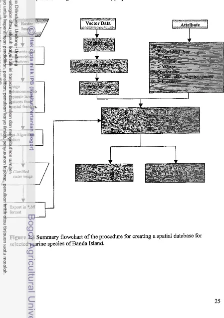
243.4 Summarized Flow-chart of Procedures
...
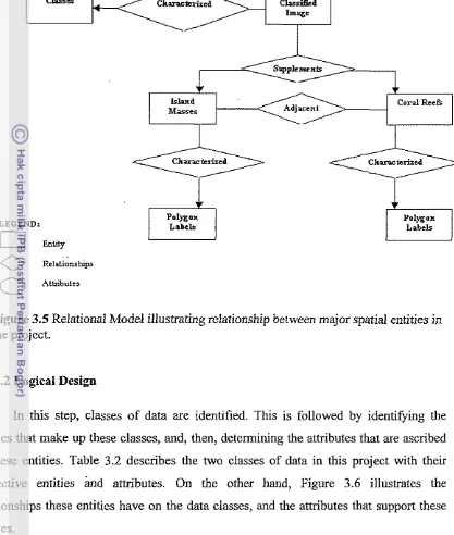
253.5 Conceptual Design, relational model
...
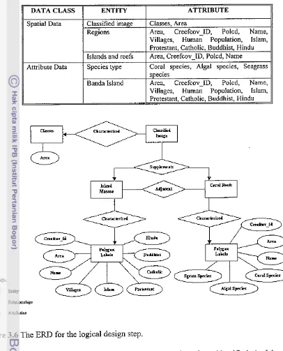
303.6 ERD for Logical Design
...
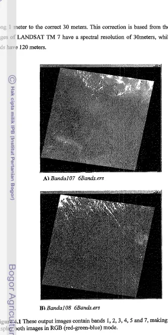
314.1 Output images from RGB processing
...
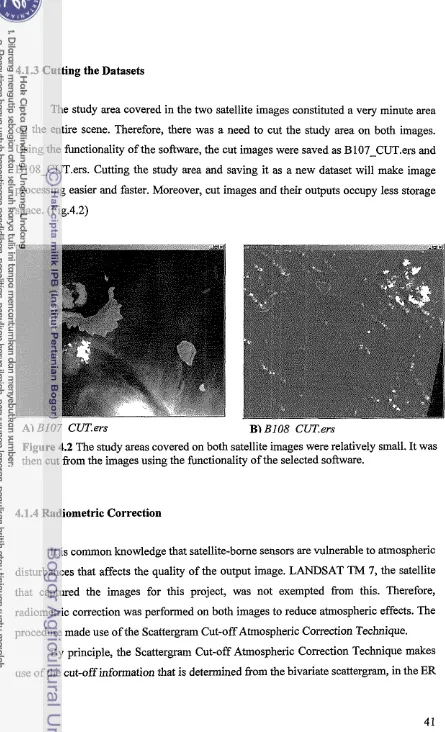
404.2 Cropped images
...
414.3 Histogram adjustments
...
424.4 Setting of 35 GCPs
...
444.5 Two classes of data in the spatial database
...
454.6 The fourth hypothetical "normalized" table
...
47...
4.7 Product design from preconceived database design 49
4.8 Potential uses of the spatial database
...
504.9 Two composite images for Bandal08
...
53. .
...
4.10 Lyzenga applied images 53
...
4.1 1 Final output for unsupervised classification of Bandal07 55
...
4.12 Re-classification of Bandal07 image 56
...
4.13 Re-classification of Bandal08 image 57
...
4.14 Map lay-out of the Mosaicked Banda Island satellite images 58
4.15 Vector data
...
604.16 The GIs set-up for Banda Island
...
614.17 The Classified Banda island view ... 62
...
List of
Tables
3.1 Conceptual Design
...
293.2 Logical Design
...
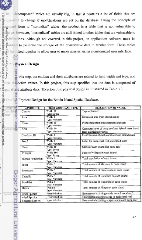
313.3 Physical Design
...
324.1 Three Tabular Forms
...
46List
of Appendices
App
.
A.
Correcting the Information of the Images...
71App
.
B.
Cropping the Images...
72App
.
C.
The Scattergram Cut-off Atmospheric Correction Technique...
73App
.
D.
Geometric Correction on the Images...
75App
.
E.
Procedure for Coral Reef Mapping Using ER Mapper 5.5...
76...
App
.
F.
Ground Control Points and RMS Error Report 82App
.
G.
Collected Data from Banda Island...
84App
.
H.
Data for Determining the kitkj Values...
86App
.
I.
Vector Metadata of Coverages...
88...
App
.
J.
Tables Supporting the Banda Island GIs 90App
.
K.
Available Data for Area...
103...
1. Introduction
1.1 Background of the Problem
Indonesia is relatively rich with species that are widely distributed, and occupy a
range of different habitats that often involve adaptation to local conditions resulting to
genetic diversity between various populations. Genetic variation is important because it
provides the basic resource needed for the creation of new industrial natural products and
high-yielding agricultural varieties of crops in order to meet the ever growing demand of
a rapidly increasing human population. These resources, known as genetic resources, yield potentially valuable products, such as chemicals, enzymes, and genes; and include
terrestrial and marine microbes, plants insects, venomous animals and marine organisms
(Putterman, 2000). The small archipelago of Banda Island, located in the province of
South Maluku, is one of several places in Indonesia that is endowed with rich marine
organisms- namely, corals and algae- that have' potential value as genetic resources. If
these marine organisms are not identified and preserved by the Indonesian government
foreign biological companies involved in commerce could exploit them through illegal
bio-prospecting. Eventually, Indonesia may loose the right to utilize these genetic
resources through legal patenting.
Already, Indonesia had taken steps to conserve genetic diversity by
conceptualizing strategies to preserve its overall biodiversity (Indonesian Biodiversity
Country Study Standing Committee, 1992). To pursue a perpetual course towards
conservation of biodiversity richness, the government had established 376 protected areas
that include national parks, nature reserves, game reserves and marine reserves. In
addition, the Biodiversity Action Plan for Indonesia (BAPI) was formulated in 1991 that
sets out the strategy for action on both in situ and ex situ conservation (Indonesian Institute of Sciences, 1999). To meet problems concerning policies, technologies and
expenses, the government had collaborated with various international agencies, where the
governments of Japan and the United States of America had jointly aided in setting up the
However, Indonesian biodiversity, which includes genetic resources, are
continually threatened. Banda Island is not spared from this environmental problem
because of the presence of human communities.
In an action plan developed by the World Resources Institute (1991) for
Indonesia, the strategy suggested coastal and marine conservation. Together with three
other concerns [in situ conservation in terrestrial parks and protected areas, in situ conservation outside the protected area network @reduction forests, wetlands,
agricultural lands), and ex situ conservation], the plan involved "outlining immediate and attainable priorities for conservation action", suggesting the seriousness of the threats
imposed on the marine ecosystem and urgency to create strategies that will preserve
them. Endangering coastal ecosystems results to severe impacts on marine biodiversity.
For example, marine genetic resources in Indonesia would likely diminish without even
being documented if no proper strategies are made to manage them effectively, and
would mean loss of potential source of income and gradual degradation of the ecological
communities.
Sustainable management entails meeting the current needs without compromising
the ability of future generations to meet their own needs. In Programme Element 1,
Sustainable Management and Use of Natural Resources, .posted in the Internet by the United Nations Environmental Programme (UNEP) committee (1997), one suggested
strategy to care for coastal and marine environments is to "develop tools and guidelines
for sustainable management and use of freshwater and coastal resources." These tools
and guidelines should be able to help local decision-makers to effectively manage coastal
resources, including marine genetic resources that would lead to economic benefits to the
local stakeholders and conservation of the coastal environment.
A spatial database developed for a coastal environment, with or without human
communities, is a likely tool that can help local decision-makers in their assessment,
auditing, formulation of strategies and guidelines for the identification, conservation and
sustainable use of local marine genetic resources. Spatial databases contain georeferenced
data with significant biophysical information of a study area, such as confirmed species
present in the area. It is often interactive so that users may be able to retrieve pertinent
If a spatial database specifying genetic resources were available to coastal managers, then
decision-making, or any kind of analysis involving georeferenced information, would be
relatively easier. The database approach allows data sharing to be more effective by
developing new applications that will facilitate data sharing with others using other
application systems.
It is then highly significant to consider developing spatial databases for
institutions or organizations (involved in the conservation biodiversity) that handle a
great deal of data that can be shared and are vital for various analyses. Such an approach
would reduce the length of time and effort needed for planning, decision-making, and reinforcement of policies. It also makes analyses and processing more efficient since the
system is computer-based.
Among the challenges facing Indonesia concerning coastal environmental
management are: (1) to create a national cross-sectoral coordinating agency; (2) develop
provincial management capabilities; and (3) to foster community and private sector
participation (Meltzer Research and Consulting, 1993). Therefore, an effective and
accessible spatial database would highly contribute in meeting some of these challenges.
1.2 Problem Conclusion
In order to conserve Banda's marine genetic diversity, conservation must begin at
the species level. To cover in situ and ex situ methods of conservation, a wide range of technologies would be needed. Technologies can be classified into: (a) 'soft' technologies
(training, management, behavioural patterns, etc.); (b) 'hard' technologies (aerial survey,
laboratory equipment, gene banks, etc.); and (c) 'high' technologies (DNA hybridization,
allozyme analysis, etc.) (Indonesian Biodiversity Country Study Standing Committee,
1993). Although the hard technologies for conservation are generally widely available,
Indonesia faces the issue of technology transfer and development.
To achieve successful technology transfer, there must be an availability of skilled
staff, clear responsibility for activities and the establishment of information systems. Indonesia had already established the Centre for Training on Conservation Management,
in Indonesia. Through this action, human resource development was expected to occur.
However, because of the large areas of conservation to be covered and the lack of focus
in efforts, the results have yet to be seen. This focus is closely linked with the need to
have an effective information system.
The Indonesian Biodiversity Country Study Standing Committee, in their 1993
report, added that in the field of biodiversity information management, there was an
existing set of proposal by the Ministry of State for Population and Environment (KLH)
and the Indonesian Institute of Sciences (LIPI) in association with The Nature
Conservancy (TNC) and several donor agencies to establish a database on environmental
resources to accommodate several of the needs mentioned above. That database required
georeferenced and map information. Therefore, the database needed to interface
effectively with the national Geographic Information System (GIs) component at the
National Coordinating Body for Survey and Mapping (BAKOSURTANAL).
1.3 Framework for Solving the Problem
If Indonesia wants to manage marine genetic resources sustainably, especially in
Banda Island, effective tools and guidelines must be developed and formulated at the
species level. This will help coastal managers and decision-makers to audit existing
marine species in the coastal area, evaluate their conditions, and formulate a strategy to
utilize them without overexploiting these resources. Developing a spatial database that
stores the name of the species- bearers of the genetic resources- and their distribution
within the coastal area, will aid in whatever task a coastal manager or any decision-maker
may be faced with.
In order to arrive at an effective plan to conserve and manage these potential
genetic resources in Banda Island, a spatial database needs to be developed to help locate
the diverse species of the small archipelago and map significant geographical features
that are seen to have direct or indirect effects to the intended management sites.
Spatial analysis is essential in planning methods of coastal conservation and
neighboring tributaries that have effect on the condition of the coastline there is difficulty
in estimating the degree of effectiveness of management over the coastal area.
Planners and decision-makers are also in need of available data coming from a
single source because the element of time is a major constraint in planning. This is where
a database will come as a solution to such problem. With significant information on the
coastal resources of Banda Island stored in a database, less time and effort is spent on
gathering and synthesizing data. A precursor database also prevents storing digital
information, collected by other researchers, in different formats that often prevent others
from integrating such formats with their data.
1.4 Objectives of the Study and Benefits
1.4.1 Objectives
The study aims to show the potential of Banda Island to protect and sustainably
manage the marine genetic resources it has. In so doing, the study involves:
1. Preparation of the spatial data by processing two LANDSAT TM7 satellite
images of Banda Island, and performing unsupervised classification on the
images.
2. Developing a spatial database for Banda Island that will show the location of all
coral, seagrass and algal species distributed among the islands of the small Banda
archipelago.
3. Creation of a digital map of the study area from an existing topographic map.
1.4.2 Benefits
Marine genetic resources are of value because of the various significant uses they
have in research and development (R&D). And since a wide range of commercial
industry have applied numerous biological technology as a means to produce and market
organisms as potential genetic resources- sources of diverse chemicals, enzymes and
genes.
Although conservation and management of coastal resources have been reinforced
because of debates over issues of ecological balance and consideration of the
stakeholders' welfare, this newly identified economic and R&D role of marine organisms
further strengthens the cause of coastal zone conservation and management. The
development of marine genetic resources into new commercial products can be a
powerful tool for conservation and economic development, and as such, marine genetic
resources ought to be incorporated into integrated coastal zone management (ICZM)
planning (Putterman, 2000).
Solid understanding of the environmental conditions of the coastal resources
within a set management site and factors that affect the state of these resources are
essential elements vital in protecting coastal resources, or improving them if degraded.
Therefore, there is a need to identify the geographical features of the coastal management
site and its surrounding attributes in order to specify the location of the marine resources,
and its distribution, and to map significant georeferenced attributes that are potential
2.
Review
of
Related Literature
2.1 IntroductionBiodiversity is a popular way of describing the diversity of life on earth: it
includes all life forms and the ecosystems of which they are a part. It forms the
foundation for sustainable development, constitutes the basis for the health of our planet,
and is the source of economic and ecological security for future generations. In the
developing world, biodiversity provides the assurance of food, many raw materials such
as fiber for clothing, materials for shelter, fertilizer, fuel and medicines, as well as a
source of work energy in the form of animal traction. The rural poor depend upon
biological resources for an estimated 90% of their needs. In the industrialized world,
access to diverse biological resources is necessary to support a vast variety of industrial
products. In the continuing drive to develop efficient and sustainable agriculture for many
different conditions, these resources provide raw material for plant and animal breeding
as well as the new biotechnologies. In addition, biodiversity maintains the ecological
balance necessary for planetary and human survival (Kumar, 1999).
2.2 Genetic Diversity
Although there is no one "correct" level at which to measure and analyze
biodiversity, because different scientific issues and practical problems find their focus at
different levels, the various levels of biodiversity can be understood in a hierarchical
fashion- genetic diversity, species diversity, and ecosystem and biome diversity (Meffe et
al, 1997). Each of these levels characterizes the main units of variation, namely genes
(genetic diversity), species (species diversity) and ecosystems (ecosystem and biome
diversity) (United Nations Environment Programme, 1995). However, genetic vari&ility
is considered to be the ultimate source of biodiversity at all levels.
Recent advances in molecular biology have provided tools needed to measure the
amount of genetic variation present in organisms. Measurements of variability within
local populations are important for testing theories about the nature and forces acting on
genetic variation that are responsible for evolutionary change. Such knowledge has
rare species so as to reduce deleterious effects of inbreeding, or determine the best
sources of individuals for reestablishing populations in areas from which they have been
exterminated. Measurements of the amount of genetic difference among species are
important for estimating rates of evolution and for establishing phylogenetic relationships
among organisms. These are significant concerns for biological consewation (Meffe et al,
1997).
2.2.1 Marine Genetic Resources
Biodiversity that is of interest to industry for its potential to provide diverse
chemicals, enzymes and genes is known as genetic resources (Putterman, 2000). These
may come from terrestrial and marine microbes, plants, insects, venomous animals and
marine organisms.
Because of rapid technological changes, the economic value of genetic resources
as a whole had increased. Moreover, as the potential use of material has expanded
considerably, e.g., increased salinity andlor cold tolerance of freshwater species through
selective breedinglselection it brings about an extension on the use of and geographic
distribution of the species. Not only are genetic resources highly significant to agriculture
and livestock, these are also important contributors to the pharmaceutical and health
industries.
In agriculture and livestock, genetic resources are used for selecting certain
species or populations for domestication and cultivation. In addition, it is also used for
genetically improving economically important species. Pharmaceutical companies are
becoming increasingly interested in the potential biochemical properties of tropical
species and varieties for developing new drugs.
In effect, biotechnology have not only found ways and means to relieve the
growing demands of the human population forecasted to double in size by the need of
this new century, it had also generated a significant amount of income. The aggregate
direct use value of biological resources and genetic material as "raw materials" in
agriculture is approximated by the potential returns on investments in research and
development of biotechnologies that may generate animal and crop breeds of potential
amounted to $100 million, and earned an estimated return of $190 million (UNEP, 1995).
Pharmaceutical prospecting of biological resources from Costa Rica is around $4.8
million per new drug developed.
Marine genetic resources have similar economic value in terms of its biochemical
properties for nutritional, pharmaceutical and industrial purposes. This potential is as
great as that of genetic resources from terrestrial plants and animals. However, unlike
terrestrial plants and animals, only a few marine species have been domesticated and the
major portion of production comes from wild organisms. The marine microalgae, for
example, represents a potentially new and largely untapped natural resource. They are
rich sources of natural products such as pigments, enzymes, fats, proteins, amino acids
and vitamins, and at present there is a great demand for microalgae as health foods for
human consumption. Microalgae are also widely used as biofertilizers and as feed
supplements due to their high content of fats and oils, the chemical composition of which
is very similar to vegetable oil. In fact, there is the potential application of these algal fats
and oils as substitutes of commercial vegetables in the future. Microalgae have also
become a target of research for bioactive compounds with neurotoxic, antitumor, or
antibiotic activity. Although other marine species have potential uses for a variety of
purposes, most are not yet known andor tapped. Therefore, there is a need to preserve
these marine species until their significant use for a rapidly growing human population is
discovered.
2.2.2 Conserving Marine Genetic Resources
The need to preserve marine genetic resources comes from our awareness that
biological products from the coding genes of various species are essential in ecological
interactions (between species, between populations of different species, between species
and its environment). It is an element, in the molecular level, that is important and vital
for maintaining a healthy and efficiently functioning environment. Moreover, preserving
genetic diversity allows for more possible combinations of traits essential in the process
of evolution.
At a human standpoint, the need to preserve marine genetic resources comes from
medicine, and industry. However, not all of it are hlly known and/or tapped. One of
several reasons is because of its degradation and eventual loss.
Genetic resources are lost either through the extinction of a species or through the
extinction of individual populations of the species (genetic impoverishment) (Salm and
Clark, 1984). The first process is final and irreversible. The second is a matter of degree
and is to some extent reversible (FAOIUNEP, 1981). In the sea, where endemism (the
restricted distribution of a species to a relatively small geographic area) is low compared
to that of land, the problem is less one of species extinction than of genetic
impoverishment. For example, no significant or detectable increase in extinction rates of
fish species has been observed in the ocean, but populations have been extinguished by
overfishing, pollution, and habitat destruction. Organisms occupying disappearing
habitats will likely never again reach their present level of genetic diversity (Salm and
Clark, 1984).
It is also important to recognize the difference between biological diversity,
reflected by the number of species, and genetic diversity, reflected by the variation within
a species. Note, for example, that land has more species than the sea, and hence greater
biological diversity. Marine organisms, however, tend to exhibit more genetic variability
(Nevo, 1978); thus, they have greater genetic diversity. Both types of diversity are
important and of use to people.
Broadly speaking, there are three ways to preserve marine genetic resources
against human-caused losses. One is establishing gene banks, "storehouses" that maintain
genes for future use (more widely used for terrestrial genetic resources). A second means
is preventing the overexploitation of species by managing the harvest, or by
supplementing the harvest of wild stocks with cultivated products, or by prohibiting the
harvest and trade of depleted and endangered species. A third means is creating protected
areas for habitats, since a major threat to the survival of some populations of species is
the destruction of critical elements of their habitat. Such coastal and marine protected
areas function as in situ gene banks, preserving genetic material within an ecosystem rather than a special "storehouse" (Prescott-Allen and Prescott-Allen, 1984).
Coastal and marine protected areas can help maintain in situ gene banks in a
or species known or likely to be of value as genetic resources (e.g., the wild relatives of farmed species or other wild species useful to people) Local extinctions and depletions of
stocks have resulted in part from habitat destruction and in part from the high demand of
such species, for example, whales, turtles, dugongs, and certain mollusks and corals
(Salm and Clark, 1984).
2.2:3 Sustainable Management of Marine Genetic Resources
Many people who live in coastal regions have small cash incomes and subsist on
local resources. The lives and destinies of these people are linked to the sustainability of
their resources. With or without conservation they will continue to turn to these
resources. Although many can manage for themselves, they still need help.
Conservation aims to satisfy short-term needs in a way that ensures the survival of
resources in long-terms. Protected areas help channel development to avoid sacrificing
one resource by harvesting another or by modifying habitats. The World Conservation
Strategy (1984) defined roles for living resource conservation for sustainable
development as its goals, which are:
1. To maintain essential ecological processes and life support systems, on which
human survival and development depend.
2. To preserve genetic diversity, on which depend the functioning of many processes
and life support systems; the breeding programmes necessary for the protection
and improvement of cultivated plants, domesticated animals, and microorganisms;
much scientific and medical advance and technical innovation; and the security of
many industries that use living resources.
3. To ensure the sustainable utilization of species and ecosystems, which support
millions of rural communities as well as major industries.
Sustainable exploitation implies that wise use (development) and careful
management (conservation) of individual species and communities together with the
habitats and ecosystems on which they depend, so that their current or potential
usefulness to people is not impaired directly or indirectly by these people. Resources
jeopardized. Such management maintains biological potential and enhances the long-term
economic potential of renewable natural marine resources.
Conservation of biodiversity in Indonesia has been a concern since the Dutch
occupation, yet limited in terms of initiative. Although mandates and regulations exist,
these overlap between the central and regional governments, among sectors, and between
public and exclusive society in certain places. Moreover, the effort of the Indonesian
government to practice conservation has not been fully linked to its utilization.
Institutions have no comprehension on the benefits of conservation, especially on long-
term benefits, and certain strategies had been ineffective (Indonesian State Ministry of
Environment, 1995).
In utilizing the Indonesian biodiversity, the government, general public and
private sectors are not always in agreement. There are conflicts of interests among sectors
in conservation areas, especially when important minerals are found (Indonesian State
Ministry of Environment, 1995). Direct harvesting of plants and animals from their
natural habitats has not been fully based on their reproductive capacity resulting to
decrease in population size and increase on limited distribution. Alteration of habitats had
caused species depletion without even documenting these species.
Information on Indonesian biodiversity, obtained from surveys and researches, is
scattered among various institutions in charge of the activities. Many have not even been
published, although a significant number had been presented as papers in national
scientific meetings. To retrieve such information, much time and energy are consumed.
Development of a database on biodiversity is an absolute need for scientific community
and planners.
Concept on sustainable utilization of the Indonesian biodiversity has not been
developed based on scientific basis. Researches on biodiversity cover a vast area but the
planning has not been integrated, so that the benefit is inadequate for making national
policy (Indonesian State Ministry of Environment, 1995).
2.2.4 Sustainable Management Strategies of Marine Genetic Resources
environment and the local communities relying on these marine resources for social and
economic purposes.
His efficiency lies, among others, on how much he knows the protected area and
the site management plan and its stated objectives, zones, and management decisions that
can readily recognize situations or activities that are not in accord with these. He must
also have sufficient knowledge of the area (both in and out of water) that he can relate the
management plan to actual field locations- identifying important animal and plant species
(Salm and Clark, 1984).
Among the resource management tools that one must have on hand are maps and
overlays to relate pertinent data with specific locations (Salm and Clark, 1984). These are
means by which biological resources become more recognizable. Conservation plans
need to be built upon our understanding of spatial distribution of biological resources,
which is generally inadequate. However, recent developments in the areas of Geographic
Information Systems (GIs) and Remote Sensing (RS) techniques have brought within
reach new ways to develop, analyze and monitor the spatial distribution patterns of
biological resources. These tools have greatly speeded up the efficiency with which the
biological resources can be mapped (Kumar, 1999).
2.3 Employing Remote Sensing and Geographic Information System (GIS)
Sustainable management of marine genetic resources is brought about by changes
in the environment caused by man and natural phenomena in the immediate surrounding.
To understand the significance of environmental changes one must view it in an
integrated perspective. Environmental problems rarely respect conventional subject
boundaries, and their solution requires both an understanding of the physical and
ecological aspects of environmental systems and the way in which they interact with
economic, social and political factors (Haines-Young, Green and Cousins, 1994).
In the 80s analytical tools for ecological studies, such as conservation of
biodiversity, did not match the scale of questions that faced ecologists and alike. At the
regional scale consistent data about the Earth's surface and its cover were difficult, time
consuming, and expensive to collect. There was difficulty in processing complex data
data. With the availability of computer-based systems for handling geographical or
spatial data, now popularly known as "geographic information systems" (GIs), many of
these difficulties had been overcome (Haines-Young, Green and Cousins, 1994).
What makes a GIs significant to biodiversity conservation and natural resources
management is its capacity to handle many layers of map information relating to an area.
Each layer describes a different aspect of its geography. One layer might hold data on,
say, sea surface temperature, another on specific location of coral species. Others might
include other pertinent data, such as, socio-economic characteristics of the human
population, distribution of other species within the same site, etc. By combining'these
layers problems that cannot be answered by using only one layer can now be solved.
Moreover, as problems change, the data can be processed in different ways to address
different issues in a highly flexible way. A GIs can also hold non-spatial attribute
information that can be associated with the various map features in a database
management system of some kind. These data can also be used to access the map
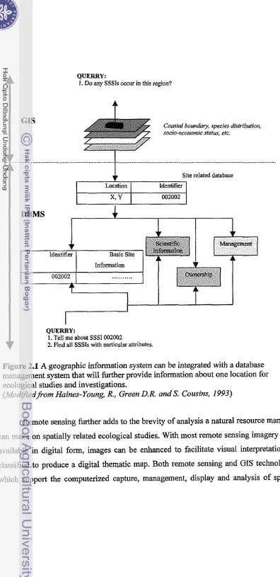
information. Ln figure 2.1 a query about the location of sites of special scientific interest
(SSSI) might be made starting either from the location on one of the map layers or by
means of text data relating to management status of the site.
Using GIs to provide spatially explicit input to ecological simulation models and
to spatially analyze the output has been a powerful method to investigate ecological
problems (Coleman at al, 1994). It is with this objective, for example, that EcoVision was
developed. EcoVision is a graphical user interface (GUI) that automates the connection
between GIs data and ecological simulation models. Through a series of menus the user
is guided through the process of selecting GIs data, connecting these data to the
ecological simulation model, conducting model simulations and viewing the results. This
shows how GIs, together with ecological tools for analysis, can increase the rate and
breadth of ecological investigations. Applied with the conservation of marine genetic
resources the result would show the same potential efficiency that can be used by a
QUERRY:
I. Do any SSSls occur in this region?
Coastal boundary, species disfributiort, socio-ecortonric status, ctc.
Site related database
Location Identifier
002002
QUERRY:
1. Tell me about SSSI 002W2
[image:164.576.51.447.17.832.2]r 2. Find all SSSls with Mlticular attributes
Figure 2.1 A geographic information system can be integrated with a database management system that will further provide information about one location for ecological studies and investigations.
(Mod9edfrom Haines-Young, R., Green D.R. and
S.
Cousins, 1993)Remote sensing further adds to the brevity of analysis a natural resource manager
can make on spatially related ecological studies. With most remote sensing imagery now
available in digital form, images can be enhanced to facilitate visual interpretation or
classified to produce a digital thematic map. Both remote sensing and GIs technology,
data have heightened monitoring and management of natural resources, including marine
genetic resources.
However, although many view GIs as a panacea solving data volume and
management problems, more important problems still underlie GIs, including the lack of
adequate "database management systems" (DBMS) software to manage scientific data
effectively and the lack of sophisticated statistical software and other analytical tools
within the GIs environment (Stafford et al, 1994).
2.4 The Concept of Database Design
Database had been defined as an integrated collection of computer data that is
organized and stored in a way that facilitates easy retrieval for the intended user.
(McLeod Jr, 1998) In order to achieve this, there must be a direct access storage device.
In principle, the database concept observes two objectives, that is, to minimize (if not
eliminate) data redundancy and to achieve data independence. This means, a database
must have data that is not stored in multiple files and that when changes are made in the
data structure it would not affect the programs that process the data. Moreover, to achieve
data independence, data specifications are placed in tables and dictionaries that are
physically separate from the programs. The programs are the ones that reference the
tables in order to access the data. Following this principle, changes to data structure are
made only once, and that is in the tables.
A database consist of tabulated data that is related to each other by data
specifications, such as a given code or ID on the item, or data element. It observes the
principle of normalization whereby the process identifies "stable" attribute groupings,
with high interdependency and affinity (Information Systems and Technology Hand-out,
2001). In the relational model, there are several standard forms of normalized tables.
These are: First Normal Form (1-NF), Second Normal Form (2-NF), Third Normal Form
(3-NF), Fourth Normal Form (4-NF), Fifth Normal Form (5-NF) and the BoyceICodd
Normal Form (BCNF). To simplify, each of these standard forms normalize tables
through specific requirements that reduce redundancy and undesirable update anomalies
attribute groupings is to go through the entire existing table and decompose it to several
tables as prescribed by the standard forms.
2.5 Database Design
Database design provides a comprehensive framework for the database. With
such a working blueprint the database can be viewed in its entirety so that interaction
between elements can be evaluated. For example, potential problems and design
alternatives can be identified. Data can be further scrutinized; if found irrelevant it can be
removed from the database system. This working framework can also show whether data
have update potential or none.
Database design allows the designer to see all the involved components of the
database and set the appropriate representation to the entities involved. It also allows
through this that one sees which parts of the database cannot be integrated and cannot be
supported by an application. In terms of future revision that may be intended on the
database, the "comprehensive firnewor!? can give a relative estimate of costs that would
be needed.
It is also recognized that database design is the most crucial step in developing
any database application. (Ashenfelter, 1999) In order to help web database designers it
was suggested that databases be developed around metaphors. Some metaphors provide
better ways of modeling certain kinds of data; others are more efficient from a storage or
access point of view. Three common types of metaphors used for designing web
databases were identified: flat files, relational databases, and object-oriented databases.
(Ashenfelter, 1999)
2.6 Steps in Database Design
Three steps in database design are known: conceptual, logical and physical.
(SDBM Lecture, 2001)
3 Conceptual Design - in this phase all entities and spatial objects are described and defined. It tells how entities will be represented in the database. This phase
represented. For example, when evaluating spatial objects, the designer might
choose among points, lines, areas or even raster cells to represent a feature. Of
course, the selection is based on the processing that will be done over these
objects. For instance, a building could either be represented as an area or a point.
The entities involved in this initial stage are both hardware and software
independent.
3 Logical Design - in this phase, the components involved are hardware independent but software specific. The logical design is usually determined by the
database management system, and gives the details about how entities are related
to each other. It is also at this phase where the type of database design, type of
data and width or range of the data is determined.
3 Pl~ysical Design - this phase is related to issues of file structure, memoly size and access requirements. The components involved in this stage are both
hardware and software specific.
Database design has nothing to do with using computers. It has everything to do
with research and planning. The design process should be completely independent of
sofhvare choices. The basic elements of the design process are: (Ashenfelter, 1999)
1. Defining the problem or objective.
2. Researching the current database.
3. Designing the data structures.
4. Constructing relationships.
5. Implementing rules and constraints.
3. Materials and Methodology
3.1 Study Area
The Banda Islands are at the heart of an area characterized by high marine
biodiversity and fascinating geological processes. They are important historical and
cultural sites (TERANGI, 2001). Lying isolated between the Sunda Shelf and Sahul
Shelf- east of the Wallacea region- the small archipelago of Banda and the Banda Sea is
approximately 140 km from the nearest landmass at the heart of the Indonesian through
flow.
The reefs around Banda Islands are considered to be among the most diverse in
the world. Its rich marine diversity is attributed to the small island's isolated condition,
complex geology and oceanography, and its unusual geographic position. Several coral
genera not reported from the Great Banier Reef have been found in Indonesian waters:
Oulastrea, Nemenzophyllia, Boninastrea, Zoopilus, Physophyllia and Indophyllia. However, the highest coral diversity in the world is still found in the waters of North
Sulawesi, Indonesia, with 80 genera.
Moreover, marine macro algae, or seaweed, and seagrasses, in very good
condition- as reported by Sutarna (1990) and by Yusron and Edward (1999) (cited in
TERANGI, 2001)- were found on reef flats. Three seagrass species were reported by
Yusron and Edward in 1999, while fifty species of macro algae were reported in 1993 by
the same researchers.
With such marine diversity of corals, seaweeds and seagrasses in Banda Islands, it
is essential that coastal managers designated on this site develop an appropriate strategy
to sustainably manage them while the entire eccjsystem remains unexploited by tourism,
commercial industry and growing local communities along the coastline. As already
recognized, these marine organisms are potentially valuable genetic resources that can be
preserved to allow natural means of variation to occur over time, and from which the
local communities may derive economic support later on when biological products from
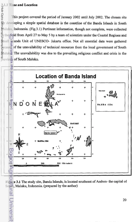
3.1.1 Time and Location
This project covered the period of January 2002 until July 2002. The chosen site
for developing a simple spatial database is the coastline of the Banda Islands in South
Maluku, Indonesia. (Fig.3.1) Pertinent information, though not complete, were collected
in the field from April 27 to May 5 by a team of scientists under the Coastal Regions and
Small Islands Unit of UNESCO- Jakarta office. Not all essential data were gathered
because of the unavailability of technical resources from the local government of South
Maluku. The unavailability was due to the prevailing religious conflict and crisis in the
province of South Maluku.
[image:169.582.51.493.92.834.2]600 Kilometers
Figure 3.1 The study site, Banda Islands, is located southeast of Ambon- the capital of South, Maluku, Indonesia. (prepared by the author)
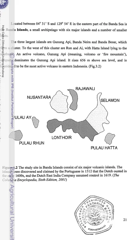
Located between 04" 31' S and 129' 54' E in the eastern part of the Banda Sea is
the Banda Islands, a small archipelago with six major islands and a number of smaller
islets.
The three largest islands are Gunung Api, Banda Neira and Banda Besar, which
form a cluster. To the west of this cluster are Run and Ai, with Hatta Island lying to the
southeast. An active volcano, Gunung Api (meaning, volcano or 'fire mountain'),
uniquely dominates the Gunung Api island. It rises 656 m above sea level, and is
considered to be the most active volcano in eastern Indonesia. (Fig.3.2)
PULAU
NUSANTARA
-'/PULAU RHUN
[image:170.573.48.470.29.826.2]PULAU HATTA
3.2 Ma