ANALYSIS OF THE SUITABILITY AND CARRYING
CAPACITY OF CORAL REEFS ECOSYSTEM TO DEVELOP
MARINE TOURISMS
IN
TUAPEJAT
THE REGENCY OF MENTAWAI ISLANDS
Z U L F I K A R
POSTGRADUATE SCHOOL
BOGOR AGRICULTURE UNIVERSITY
BOGOR
STATEMENT LETTER
I state that this thesis, where its title is: "Analysis of the suitability and carrying
capacity of coral reefs ecosystem to develop marine tourisms in Tuapejat, the
Regency of Mentawai Islands ", is result of my writing and it is not ever used by other student at university. All of these data and information sources that used to
support this thesis have been already stated clearly and they can be examined to
be true
Regency of Mentawai Islands, SWOT analysis (Strength, Weakness, Opportunity, Threat) was used, namely by identifling various factors systematically to formulate the strategy.
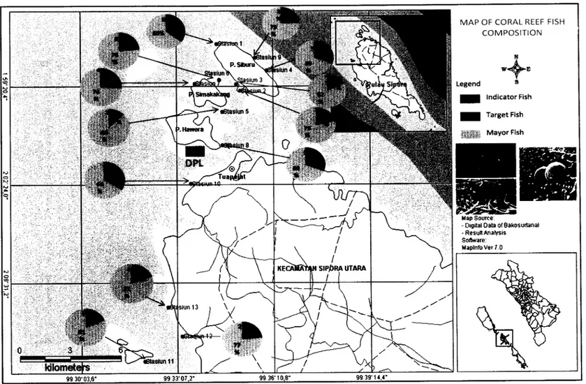
The area of coral reef ecosystem that exists in North Sipora (Tuapejat) reaches 55.0716 krn2, which consists of 30.7747 km2fi.inging reef and 24.2969 km2 shoal reefs. From the observation of the coral reef condition using LIT method in 13 permanent transect stations it can be seen that there were 6 stations that belong to coral reefs of good category, and 7 stations that belong to coral reefs of sufficientlaverage category. The category division refers to: 0
-
24.9% belonging to bad condition; 25-
49.9% belonging to average condition, 50-
74.9% belonging to good condition; and 75100% belonging to very good condition( Gomes and Yap, 1989). The percentage of life form coral reefs cover in general was dominated by hard coral Non Acropora. Coral of the genus Acropora is only dominant in station 12 and station 13. The other locations were dominated by Non Acropora from the genus Porites, Pocillopora, and Heliopora.The results of UVC that was carried out in 13 stations show that there are 198 species of coral reef fish which belong to 33 groups. The coral reef fish species can be found mostly in station 9, in which there were 97 species, while the lowest type was found in station 10, in which there were 53 species of fish. The highest number was found in station 9, in which there were 2,322 individual fish, whereas the lowest in station 10, in which there were 608 individual coral reef fish.
The results of the marine tourism suitability analysis show that all the 13 research locations can fulfill the requirements for diving tourism (4 locations very suitable and 4 locations suitable). The locations that can fulfill the requirements for snorkeling tourism were 5 locations (2 location very suitable and 2 locations suitable). The areal carrying capacity to accept tourists vary according to the areal of the coral reefs. The area that has suitable category level is utilized only half of the time utilized by the very suitable category level in a day.
The SBE analysis towards 39 pictures/photos (3 photos in each station) showed that 58.97% respondents have high interest level, 28.21% have average interest level, and 12.82% have low interest level. Thus in general tourists are quite interested in the beauty (landscape) of the coral reef ecosystem in Tuapejat.
For the sustainability of marine tourism development of diving and snorkeling categories, some strategies resulting from SWOT analysis are recommended, namely: zoning the area of coral reef ecosystem according to the level of its suitability and its purpose, socializing the regulations concerning coral reefs management and layout, establishing regulations concerning permit and management of marine tourism area of conservation basis, improving human resource development and management facilities and its infia-structure, increasing the involvement of local people in management, increasing the promotion of snorkeling and diving tourisms working together with the management of maritime tourism, and increasing the facilities and infra-structure of coral reef ecosystem resource management
Copyright
0
IPB, 2009
Copyright reserved by Law
Forbidden to quote part or all of these writings or without including the source, quotation is only for educational purposes, research, writing papers, drafting reports, writing criticism, or review an issue, and citing it does not harm the interests of fair IPB
ANALYSIS OF THE SUITABILITY AND CARRYING
CAPACITY OF CORAL REEFS ECOSYSTEM TO DEVELOP
MARINE TOURISMS IN TUAPEJAT
THE REGENCY OF MENTAWAI ISLANDS
Z U L F I K A R
T h e s i s
As one of the requirements for Master of Science degree In Coastal and Marine Resources Management
POSTGRADUATE SCHOOL
BOGOR AGRICULTURE UNIVERSITY
BOGOR
Thesis title : Analysis of the suitability and carrying capacity of coral reefs ecos
Name : Zulfikar
Registration Number : C 252070234
Approved by
Advisory Board
Co-Supervisor
Acknowledged by
&Head of Marine and Coastal Dean of Post Graduate School
Resources Management Program
P
Prof. Dr. Ir. Mennofatria Boer, D
PREFACE
Thank to Allah SWT for God's mercy that given to Author who has
already finished writing this thesis. Title of this thesis is "Analysis of the
suitability and carrying capacity of coral reefs ecosystem to develop marine
tourisms in Tuapejat, the Regency of Mentawai Islands
",
that has been carried out from May until June 2009. This thesis includes three main studies, the potentialand the condition of coral reef ecosystems, suitability and carrying capacity of
coral reef ecosystems for marine tourism, and development plans of coral reef
ecosystems sustainably.
In connection with it has already finished this thesis, Author would like to
thank to :
1. Mr. Dr. Ir. Yusli Wardiatno, M.Sc and Mr. Dr. Ir. Isdradjad Setyobudiandi,
M.Sc, for your helps in guiding Author to finished this thesis
2. Mr. Prof. Dr. Ir. Mennofatria Boer, DEA, as head of Study Program and all
lecture and all staff in Study Program of Marine and Coastal Resources
Management
3. Director of PMO COREMAP I1 of General Directory of Marine, Coastal and
Small Islands, Ministry of Marine Affair and Fisheries for scholarships given
to Author.
4. Mr. Edison Saleleubaja (Regent of Mentawai islands Regency) which has
been given the task of studying the author to continue this studies
.
5. To my father (Zulkifli MS, alm) and Hj.Nurbaida mother's love and affection
for the infinite and all the brothers who always give a prayer and blessing to
the author.
6. Author special tanks to Author's wife, Sari Dewi SH, for her love and
support, and also Author's children, Muhammad Raihan Fikar and Najla
Khairunnisa Fikar, who has given love and affection, patience, sacrifice and
prayers for success in studying and completing this study in IPB.
Bogor, November 2009
BIOGRAPHY
The author was born on February 1 1, 1974 in Padang City, West Sumatera
Province as third children of five children from Zulkifli (alm) and Hj. Nurbaida.
Elementary school until Senior high school, Author finished in Padang City. In
1993, Author studied at Department of Aquaculture, Fishery Faculty, Riau
University in Pekanbaru, Riau Province and graduated in 1998. In November
2007, Author studied at Marine and Coastal Resources Management, Postgraduate
School of Bogor Agriculture University (IPB), on Master of Science degree (S-2)
of Sandwich Program, which is a joint program of Ministry of Marine Affair and
Fisheries with Bogor Agriculture University (IPB), which is funded
(scholarships) of the Coral Reef Rehabilitation and Management Program
(COREMAP) Asian Development Bank (ADB). Lectures are conducted
Sandwich Program cooperation Bogor Agriculture University (IPB) with Xiamen
University, Fujian Province of China. First and second semester in Bogor
Agriculture University (IPB), while the 3rd semester at Xiamen University
.
Introductory language of courses in English.Currently, The Author working as a staff of Marine and Fisheries Office
of Mentawai Islands Regency, West Sumatra Province. Earlier in the year 2007,
the author has served as Head of Coastal and Small Islands Management in
LIST OF CONTENTS
Pages
...
...
LIST OF TABLES xi11
...
LIST OF IGURES xv
...
LIST OF APPENDIXES xvi
1 FOREWORD
...
11 1 Background
.
...
11.2 Problem Formulation
...
31.3 Frame of Thought
...
31.4 Research Objectives
...
51.5 Scope of Study
...
52 LITERARY REVIEW
...
72.1 Marine Ecotourism
...
7...
2.2 Ecosystem of Coral Reefs 10...
2.3 Potentialities of Marine Tourism of Coral Reef Ecosystem 12...
2.4 The purpose of marine tourism development 13 2.5 Areas Suitability and Carrying Capacity of Coral Reef Ecosystem..
16...
2.6 SWOT Analysis 19
...
3 RESEARCH METHODOLOGY...
3.1 Time and Place
...
3.2 Materials And Methods Of Data Collection...
3.3 Data Analysis
...
3.3.1 Ecological Data Analysis
3.3.2 Analysis of Suitability Matrix for Snorkeling, Diving and Indedex of Tourism Suitability
...
3.3.3 Analysis of the Area Carrying Capacity and the Utilizationcarrying Capacity
...
3.3.4 Analysis of Coral Reef Area Zonation
...
3.3.5 Analysis of Landscape Quality of Coral Reef Ecosystem...
...
3.3.6 Analysis of Management Strategies
...
4 RESULTS AND DISCUSSION 36
...
4.1 General Condition of the Region 36
...
4.1.1 Geographical Condition 36
...
4.1.2 Population 38
...
4.1.3 Prosperity 39
...
...
4.2 Potential and Condition of Coral Reef Ecosystem
4.2.1 Coral Reefs
...
4.2.2 Coral Reef Fish...
4.2.3 Mega Benthos...
...
4.3 Waters Quality
4.3.1 Current Speed
...
4.3.2 Depth and brightness...
4.4 Suitability of Areas for Developing Snorkeling and Diving Tourism...
objects
4.4.1 Suitability for Snorkeling Tourism
...
4.4.2 Suitability for Diving Tourism...
4.5 Carrying Capacity of Coral Reef Ecosystem to Develop MarineTourism
...
...
4.6 Zonation Planning to Develop of Diving and Snorkeling Tourism...
4.7 Evaluation of Visual Aspects of Coral Reef Ecosystem
...
4.8 Policy for Developing a Marine Tourism Area
...
5 CONCLUSION AND RECOMMENDATION
5.1 Conclusion
...
5.2 Recommendation...
REFERENCES
...
APPENDIXS
...
LIST OF TABLES
Pages Locations, positions and diving depth in the research stations in Tuapejat
Village, North Sipora District of Mentawai Islands Regency
...
Suitability Matrix for the Area of maritime Tourism of Snorkeling...
Category.
Suitability Matrix for Area of Maritime Tourism of Diving Category.
...
Ecological potential of visitors (K) and area of activities (Lt)....
Prediction of time needed for each tourism activity...
Composition of Tuapejat Village population who work according to main fields of job and sex in 2007.....
Composition of Tuapejat Village residents aged 6 years or more according to their highest educational level that they have pursued and
...
sex, in 2007..
Average income per month of the people's households in Tuapejat Village according to types of employment, in 2007..
...
The percentage of life coral cover and life form coral community in the research stations using the LIT method in Tuapejat Waters, the Regency
...
of Mentawai Islands..
The number of fish individual and species per research location based on the calculation using the Underwater Visual Census (UVC) method
..
Abundantly of Mega Benthos in each research station with calculating results using the Reef Check Benthos method...
The average current speed in each research location that was measured
...
during the research
Depth and brightness of waters in each research station
...
Analyzing results of suitability matrix for maritime tourism of snorkeling category...
Analyzing results of suitability Matrix for maritime tourism of diving category...
Allotment of the area based on types of tourism according to areal
. . .
suitability.....
Supportingltypical factors and limiting factors for developing tourism of diving and snorkeling categories in Tuapejat
...
Carrying capacities of the area (CCA) based on level of suitability (STI) with time allotment for snorkeling tourism
...
Carrying capacities of the area (DDK) based on level of suitability (STI)...
with time allotment for diving tourism
...
The estimation of SBE scores
SBE scores of each landscape' photo and each research station
...
The classification of SBE scores is based on the highest. average and...
low categories
SBE scores on each characteristic of the coral reef ecosystem
...
Internal Factor Evaluation (IFE) matrix for developing maritime tourismof diving and snorkeling categories in Tuapejat
...
External Factor Evaluation (EFE) matrix for developing maritime tourism of diving and snorkeling categories in Tuapejat...
Strategies for Developing Maritime Tourism of Diving and Snorkeling...
Categories in the SWOT Matrix ModelEstablishing Strategic ranks . SWOT analyzing strategies
...
Determining the strategy priorities of developing maritime tourism (diving and snorkeling) in Tuapejat...
xiv
LIST OF FIGURES
Pages The flow diagram of Analytical Frame of Thought of Coral Reef
Management in order to develop Marine Tourism in Tuapejat
...
The Map of Research Location in Tuapejat, Mentawai Islands...
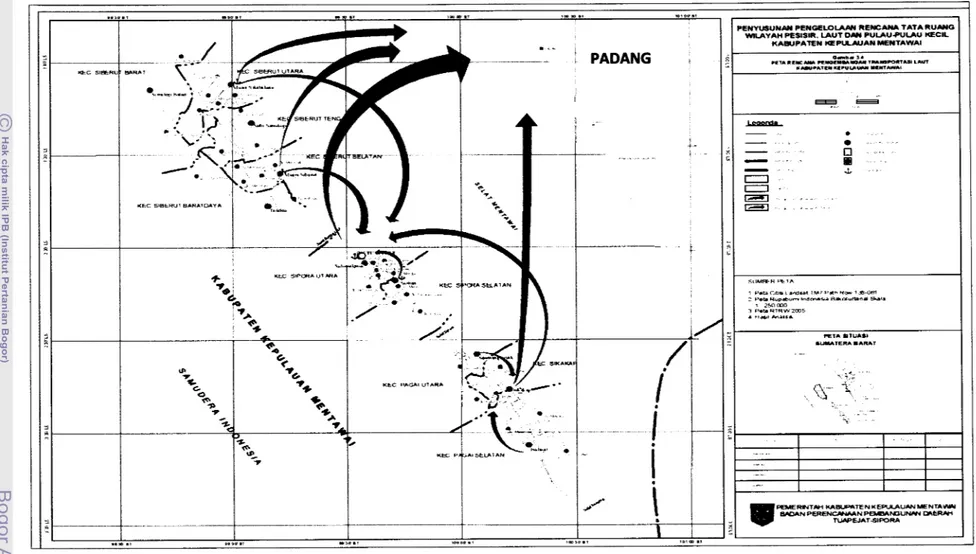
The Map of Marine Transportation Line to Mentawai Islands From Padang City, Sumatera Province. . .
. . . .. . .
.
.
.
. .
.
.
. ...
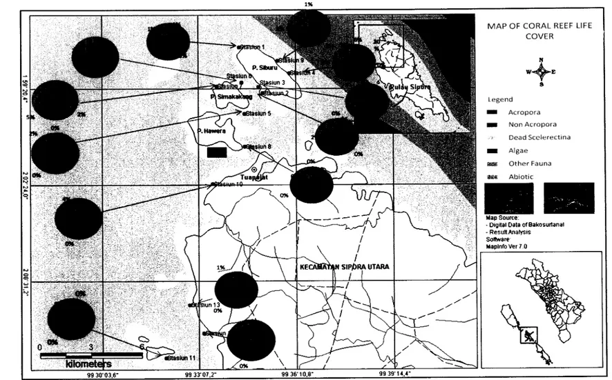
The map of the percentage of life form coral reefs in each research station. .
.
. . .
.
.
.
. .
. .
. . .
. .
.
. . . .
.
. . .
.
.
.
. . .
. .
.
.
.
. . .
.
. . .
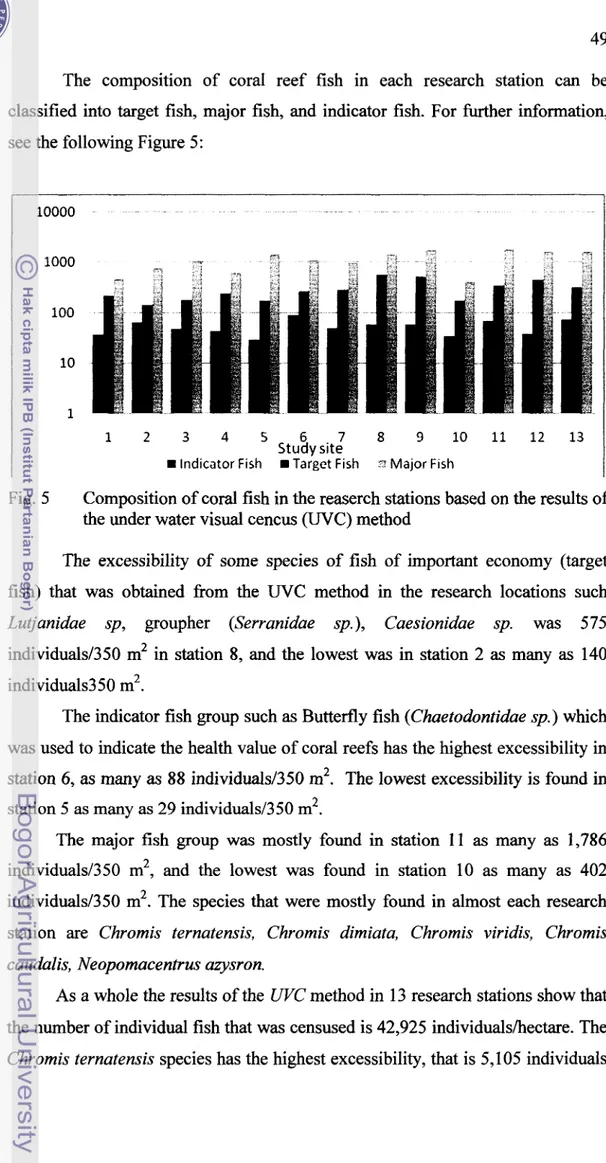
Composition of coral fish in the research stations based on the results of the under water visual census (UVC) method. . . .
.
. . . ...
The map of abundant of fish composition in each study site. . .
Abundantly of Mega Benthos in each research station with calculating results using the Reef Check Benthos method. . . ...
The average level of sea surface waters (MSL) in the waters of West Sumatera. . .
.
. . .
.
. .
.
. . .
. .
.
. . .
.
. . .
.
. .
.
.
. .
.
. .
.
. . .
.
. . . .
Map of zonation of conservation area in Sipora Island. . .. . .. .
..
.
. .
. .. .
...
The map of suitability area for marine tourism for diving and snorkeling category in Siburu Island... . .
.
. . .
. .
.
. . .
..
The map of suitability area for marine tourism for diving and snorkeling category in Simakakang Island... .
. . .
...
The map of suitability area for marine tourism for diving and snorkeling category in Pitotogat Island.
. . .
.
.
. . .
.
. . .
.
. . . .
.
. .
. . .
.
. .
...
The map of suitability area for marine tourism for diving and snorkeling category in coastal of Tuapejat.
.
...
. . .
. .
.
.
.
. . . ...
The map of suitability area for marine tourism for diving and snorkeling category in Pitojat Besar Island... . .
...
The map of zonation plan to develop of marine tourism for diving and snorkeling category.. .
.
.
. . .
.
. . .
.
. . .
. . .
.
. . .
.
.
. . .
.
...
Distribution of SBE scores from landscape photos of coral reef ecosystem that have been evaluated. . .
. . .
.
.
. . .
. .
. . .
.
.
..
Composition of SBE Score respondents' interest to Coral Reef
LIST OF APPENDIXES
Analysis Result of Coral Reef Benthic Life Form in Study Site with LIT Method
...
Analysis Result of Coral Reef Fish in Study Site with UVC Method...
Measurement Result of Water Quality in Study Site
Analysis Result of Marine Tourism Suitability Matrix for Snorkeling
...
Category in Study Site
Analysis Result of Marine Tourism Suitability Matrix for Diving
...
Category in Study Site..
Coordinate of Geographic Position of Area Zoning for diving and
...
snorkeling to measure of the area wide..
Questioner model to consider of respondent attracting to object in coral reef ecosystem to take The SBE (Scenic Beauty Estimation) Method.
...
Analysis Result of Scenic Beauty Estimate (SBE) to object landscape
...
of Study Site
Landscape (Figure) to Analysis of Scenic Beauty Estimation (SBE).
..
Pages
105
1 FOREWORD
1.1 Background
The regency of Mentawai Islands is the only region in West Sumatera
which is an archipelago. Geographically its location is separated from other
regenciesltowns in West Sumatera because it is separated with a sea. Located in
West Sumatera in the Indian Ocean, it is a group of islands whose formation is a
kind of tectonic islands.
As an archipelago, fishery and marine resources become the reliable basic
capital of developing the region. Mentawai Archipelago has a potential fishery
and marine tourism development, whose coastal area is surrounded by sea, and
some small islands which have natural forest charm and specific cultural tradition.
Mentawai Islands Regency has a coastal line as long as 2,054 km and
consists of a group of 4 big islands (Siberut Island, Sipora Island, North Pagai
Island and South Pagai Island) and 94 small islands. This area as a whole is
surrounded by sea, and it has a potential coral reef ecosystem. The coral reef
ecosystem as one of the main ecosystem in the coastal area specifically plays an
important role to protect the beach and from tides. Ecologically it functions as a
habitat of various marine biota, such as a shelter, a place for searching food, for
spawning, and as a nursery ground.
Furthermore, the beauty of the coral reefs can become an interesting
marine tourism object. Utillization of coral reefs as one utilization of the
environmental services in the form of marine toursim such as diving and
snorkeling. Diving and snorkeling are a form of marine tourism that is favored by
coral reefs. If this can be managed well it can support the regional income and it
can give an opportunity for the local people's economy to grow.
Coral reef ecosystem is an ecosystem that is subject to environmental
changes due to natural disturbance as well as human disturbance. When
developing the coral reef ecosystem area as a marine tourism area which is
sustainable, it is important to apply ecotourism concepts, namely a tourism
and conservation, and can improve the quality of inter human relationship, the
quality of the local people and also can keep the quality of the environment. To
sustain the coral reef ecosystem as a utilization of marine tourism, it is necessary
to use an ecotourism concept.
Conceptually, ecotourism can be said as a concept of developing
sustainable tourism in order to support the efforts of conserving both the natural
environment and culture, and to increase people's participation in management, so
that it can give benefits to local people. From the management point of view,
ecotourism can be said as a responsible tourism activity in a natural environment
or an area that is made based on natural norms, and economically can be sustained
to support the environmental conservation and to improve the local people's
welfare. Integrated marine ecosystem management, promising investment
planning, good layout utilization, and the local people's orientation can improve
the quality of human beings that very much depend on marine resources. Besides,
the natural environment is also well sustained. Ecotourism whose area is relatively
limited usually has a specific nature, so it is necessary to consider the carrying
capacities for its utilization. The carrying capacity here means how to arrange the
number of visitors and to determine the location for each related activity.
Tuapejat is the capital regency of Mentawai Islands, which is the main
gate to this Islands. In the Regional Tourism Development Chief Planning
(Rencana Induk Pengembangan Pariwisata Daerah
-
RIPDA), Tuapejat belongsto a developing area of marine tourism. The coral reef ecosystem area in Tuapejat
is planned to be an area of conservation. Nowadays, three out of seven islands in
Tuapejat have been managed by investors as marine tourism areas. The existence
of data about potentiality and carrying capacities of coral reef ecosystem in the
coastal areas and small islands will be useful to build the sustainable marine
tourism for the regional development. At this time data of the research results or
studies are still very limited to support potentiality, suitability and ecosystem
carrying capacities for coral reef ecosystem in the coastal areas and small islands
in Tuapejat waters for the development of the marine tourism.
For the needs of developing marine tourism in the areas of coral reef
Good management needs data and information about coral reefs. As an initial step
to manage and develop coral reef ecosystem for marine tourism, data and
information about its condition must be available.
1.2 Problem Formulation
From the problems mentioned in the background, the problems that
underline this research can be formulated as follows:
a. Lack of data of coral reef ecosystem resource potentialities in Tuapejat.
b. The absence of studies on the suitability and carrying capacities of coral
reef ecosystem for the development of marine tourism in Tuapejat.
c. The absence of management of coral reef ecosystem area for the marine
tourism activities.
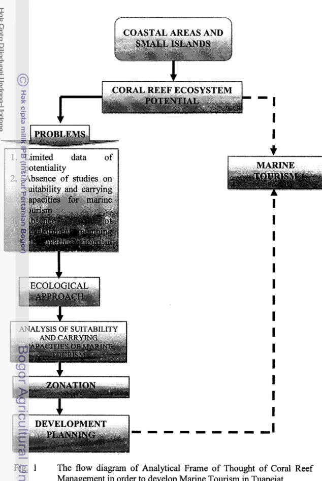
To identify the problems more easily, look at the following diagram of
problem approach in Figure 1 below.
1.3 Frame of Thought
The frame of thought that underlines this research is the importance of a
study of suitability and carrying capacities or coral reef ecosystem in order to
develop marine tourism in Tuapejat, the Regency of Mentawai Islands, so that
data of potentialities and environmental carrying capacities for the development of
ecologically-based marine tourism.
The coral reef ecosystem that is available in the coastal areas and small
islands gives a number of benefits to the people in the coastal areas. Besides, it is
a habitat of a number of marine biota, and a place for the people to earn a living
and to develop the region. It also contains an esthetics that can be developed as a
tourism object that can become a source of the income of the region and the
stakeholders involved in it. The meeting of various interests in the coastal areas
unavoidably can create conflict of interest from the utilization of various parties
that are involved in it. On the one hand, the limited ecosystem resources of coral
1. Limited data
potentiality
I
I
ANALYSIS OF SUITABILITYI
On the other hand, the sustainability of the existing resources needs to be
managed and conserved well. The conflict of interests in the end will put
ecological importance as an object that will be sacrificed, whereas its ability as an
ecosystem to recover the condition like the original will be too late. Slowly and
surely the condition of the coral reef ecosystem will be destroyed and it is not
possible that one day it will extinct.
Being aware of the importance of the existence of coral reef ecosystem in
the coastal areas and small islands in Tuapejat which is related to the concept of
environmental balance which has so far been adopted, and also considering the
efforts to conserve the nuclei plasma resources (to maintain the existence of bio-
diversity), it is necessary to carry out a study on suitability and carrying capacities
for sustainable development and utilization of marine tourism.
1.4 Research Objectives
The objectives of this research are as follows:
1. To identify the potentialities of coral reef ecosystem resources in the
coastal areas and small islands in Tuapejat.
2. To carry out a study of suitability and carrying capacities of coral reef
ecosystem in order to develop marine tourism in the coastal areas and
small islands in Tuapejat.
3. To make a strategy of managing the marine tourism in the coastal areas
and small islands in Tuapejat based on the types of marine tourism that can
be developed.
1.5 Scope of Study
The scope of the research includes the following :
1 . Collectng ecological data of coral reef ecosystem and socio-economical
data that are related and that support the research results.
2. Analyzing the suitability and carrying capacities of coral reef ecosystem
in order to develop marine tourism and the importance of conserving the
coral reef ecosystem in the coastal areas and small islands in Tuapejat, the
3. Zoning and planning the management of the coral reef ecosystem areas to
support the development of tourism activities and to sustain the
conservation of coral reef ecosystem.
4. To make a strategy of planning for developing the marine tourism of
2 LITERARY REVIEW
2.1 Marine Ecotourism
Tourism activities not only produce beautiful or ideal things, but also
produce negative things in their surrounding and the local community because too
intensive and simultaneous activities will not be well managed, and finally they
will destroy the resources that have made them available. Therefore, developing
ecotourism must be carried out sustainably, meaning it must pay attention to the
. .
environment, the community, and the economic movements happening before and
during the on-going ecotourism.
The International Ecotourism Community (IES) gives a definition of
ecotourism as follows, namely a form of responsible journey to natural areas
whose environment is protected and it can enhance the local sociaty's prosperity.
In theory and practice ecotourism grows from the criticism on mass-tourism,
which is considered to destroy its basic resources, that is environment and culture.
This criticism produces many new terms, such as an alternative tourism,
a responsible tourism, a community-based tourism, and an ecotourism (Aoyama
2000). A general reason for adopting this concept is because it can reflect tourism,
including that of big or mass -scope, folowing the sustainable principles and it
can tighten the relatonship among nations.
Ecotourism must be able to lift up the dignity of local people who in
general have the position of relatively low-bargaining. During the development
Aoyama (2000) said that some standard criteria about how an ecotourism sho-uld
be accepted in general are as follows:
-
Environmentally conserved. If an ecotourism is not an instrument of conservation, then it will degrade the existing resources.-
Economically beneficial. If an ecotourism is not beneficial, then the capital that has been spent will not return for the conservation, and there will not beany insentive for the utilization of alternative resources.
Choosing ecotourism as a concept of developing coastal tourism is based
on some major elements, namely (1) ecotourism very much depends on the quality
of natural resources, historical and cultural remains, (2) ecotourism involves
socity, (3) ecotourism can improve awareness and appreciation on nature, values
of historical and cultural remains, (4) it will encourage the growth of ecotourism
in national as well as international level, (5) ecotourism can be used as a means of
sustainable economy. In other words, maritime tourism offers a concept of low
invest - high value for the coastal resources and environment, and thus makes it a
powerful means of the people's participation since all the production assets use
and belong to the local people (Dirawan 2003).
The concept of maritime tourism is based on the view, natural uniqueness,
ecosystem characteristics, typical cultural arts and characteristics of the people as
a foundation force that is owned by each area. Wight (1993) is of the opinion that
maritime tourism is a special market for the people who are aware of environment
and interested in watching nature. Steele (1993) expresses the ecotourism
activities as a process of economy that markets an interesting and unique
ecosystem. Low Choy and Heillbronn (in Nurisyah 1998) formulate five basic
factors of definition when determining the major principles of ecotorusim,
namely:
1. Environment; ecotourism relying on natural and cultural environment that
is relatively unpolluted or undisturbed.
2. Community; ecotourism must give direct benefits ecologically, socially,
and economically to the people.
3. Education and experience; with their own experience, ecotourism must be
able to improve their understanding of natural and cultural environment.
4. Sustainability; ecotourism can give positive contribution for the
sustainability of ecology of the environment, in the short term as well as
long term.
5. Management; ecotourism must be managed well and can ensure the
sustainability of the nature and culture with the purpose of improving the
Natural ecoutourim activities can give positive as well as negative impacts
on its surrounding, both on the tourism areas and on the local socio-culture.
Negative impacts on the nature generally happen as a result of unadequate
planning and management; for example, tourism planning development does not
comply with the carrying capacity, and the people lack in awareness and
knowledge of environmental conservation (Dahuri 1993).
A region that is to be developed as a tourism area needs good ,
comprehensive and integrated planning so that it can reach the objectivities as
expected, and can minimalize the negative impacts, from the ecological,
economical, socio-cultural as well as legal point of view. Tourism development
planning is determined in order to make balance the potentiality of resources and
services that are owned and demand or interest of the visitors. Offer components
consist of : attractions (natural and cultural beauty potentialities and tourism
activities), transportation (accessibilities), information and accommodation
services and so on. Demand components, on the other hand, consist of tourism
market and visitors; motivation (Gunn in Yahya 1999).
Basically elements of life environment can be developed as a tourism
object as long as these elements can be prepared well through human ability with
their technological touch, and as long as they can fulfill the tourists' needs.
Tourism development needs integrity and thorough study and planning so that it
will not fall into developing infi-a-structure and tourism by sacrificing its own
resources and tourism object. Tourism development needs to pay attention to
demand of the tourists, but is not oriented merely on market. Tourism
development needs integrity in planning and formulating objectives (Joyosuharto
2001).
Challenges in developing tourism are making use of the existing coral reefs
continuously without causing adverse effects. This is important because marine
tourism activities basically combine two systems, namely human actitivies and
marine ecosystem of the coral reefs. The presence of maritime tourism activities
very much depend on natural resources, among others coral reefs. If there is a
destruction on the coral reefs it will make less the attractiveness of tourism in
In line with that there are a number of requirements that must be fulfilled
to sustain tourism, namely: (1) tourists must consume the product and service of
tourism selectively, meaning that the product is not obtained by over-exploiting
the resources, (2) tourism products must be environmentally-based and tolerant to
local culture, (3) local community must be involved in planning, implementing
and monitoring the tourism development, (4) the local community must also gain
benefits fairly from the tourism activities, (5) the bargaining position of the local
community should increase (Darnanik dan Weber 2006).
2.2 Ecosystem of Coral Reefs
Coral reefs are formed frm massive sediment of calcium carbonate
(CaC03), which is produced by coral organisms (hermatypical coral) fiom filum
Cnidaria, Ordo Scleractinia which lives symbiotically with single-celled algae
Zooxanthellae, and there is a little calcified algae and other organisms that secrete
calcium carbonate (Nybakken 1992). In the small islands, there is a lot of coral of
different types that can be found in the fringing reef, whereas in East Indonesia
there is a lot of ring coral called atoll (Bengen 2006).
The coral reef ecosystem is a part of a coastal natural resource which is
considered to "crital habitat". It is because the environmental condition is an
integration of mangrove ecosystem and sea grass. Ecologically, the coral reef
ecosystem is very sensitive towards environmental changes such as temperature
change, turbidity and salinity. Distribution of coral reefs is also influenced by
thoses factors. If the parameter condition of the waters is different, such as
temperature, salinity, and waves, the species and diversity of coral reefs will also
be different (Veron 1986).
Environmental parameter that can determine the coral reef life very much
(Nybakken 1992), are anlong others:
k
Temperature, coral reefs can grow optimally in the temperature betweenP Depth. Most coral reefs live in the depth of up to 25 m or less, but they
cannot develop in the waters depper than 50 -70 meters. Depth is closely
related to sun rays that can get into the waters.
P Light. This parameter is a limiting factor of coral reef life because it needs
zooxanthella to phosynthesis. Zooxanthella is a kind of plant that
associates in the body of coral animals. Besides, zooxanthella can give
beautiful colors to coral reefs, and this makes it attractive as a tourism
object for diving and snorkeling.
P Salinity. Coral can only live in the noral salinity of sea water, namely in
the range of 32
-
35 '%. Out of the range, coral growth can be disturbed and can result in death of the coral animals.P Sediment. The existence of sediment will cover and block the structure of
feeding coral, and thus hinder the sun rays into the waters.
P Waves. The absence of waves and current will make it possible to create
sediment on the coral reefs; furthermore, plankton supply and fresh water
which is rich in oxygen will diminish.
Coral reefs can adapt themselves and on the other hand can modify their
physical environment. Therefore, physical factors of coral reefs have a number of
differences according to their areas. Temperature gradient and salinity are the
major limiting factors for spreading and growing coral reefs (Jones dan Endean
1973)
Coral reef ecosystem is an ecosystem which is subject to disturbances made
by human, and its recovery will take a long time. There are some opinions which
say the opposite. Coral reef ecosystem is an ecosystem that is dynamic, unsettled,
and able to improve itself fi-om natural disturbances (Dahuri 2003).
In general degradation of coral reef ecosystem happens due to two major
factors, namely human activities (anthrophogenic causes) and natural causes.
Hman activities that can cause degradation of coral reefs, are among others: (1)
coral mining and coral removal, (2) fishing using destructive equipment or
methods, (3) overfishing, (4) water pollution, (5) coastal area establishment
activities, and ( 6 ) upstream area establishment activities. Meanwhile,
global warming, natural disasters such as storms, tectonic earthquake, floods and
tsunami, and other natural disasters such as El-Nino and La-Nina (Westmacott et
al. 2000).
Coral reef threat due to coastal area establishment is analyzed based on the
distance to the centre of the residential area, the vastness of the residential area,
the rate of population growth, and the distance to the airport, to the mining, to
tourism facilities, and to diving central facilities. The results of the analysis show
that 25% of coral reefs in this area are threatened by coastal establishment. Forest
logging, change of land-use, and agricultural malpractice, all cause increasing
sedimentation and access of soil nutrients into the water catchment area. Sediment
in the water column will affect coral growth, or even cause coral extinction. High
content of soil nutrients in the river flow can enhance the growth of poisonous
algae. This condition will enhance other algae growth that will undoubtedly not
only make use of the sun energy but also impede colonization of coral larvae by
attaching itself on the substrate that becomes a place for coral larvae to grow
(Tomaschic et al. 2002).
2.3 Potentialities of Marine Tourism of Coral Reef Ecosystem
The area of coastal and small islands are a very great asset of marine tourism
that is supported by geological potential and characteristics which are closely
related to coral reefs, especially hard corals. Besides, the condition of these small
islands that are not populated, logically will give a qualified beauty and originality
of its own bio-diversity. Typologically these small islands especially those that are
very small and of tropical type land are closely associated with coral reefs
(Bengen and Retraubun 2006).
Benefits that can be given by coral reefs are very significant and diverse.
These benefits can be identified into two types, namely direct benefits, that is as a
habitat for fish resources (a place for feeding, breeding, and nursing), coral stones,
tourism, research entity, and other water biota benefits; indirect benefits, that is
coral reefs function as a coastal abrasion restrain, bio-diversity, and so on
Coral reefs can be used as a source of foreign exchange that is obtained
from divers and other maritime tourism activities. Nowadays, various types of
biotas that live on the coral reef ecosystem can in fact contain bioactive
compounds that are useful as medicinal, food and cosmetic materials.
Furthermore, coral reefs also have their own attractiveness and become a source
of attention for experts, students, pharmaceutical industries as an object of
research (Dahuri 2004).
Based on rating carried out by international tourism agencies, some areas in
Indonesia with their own resources have the highest rating if they are observed
from marine tourism attraction compared to other areas in the world. Some
successful marine tourism areas in the world are, among others, the Great Barrier
Reef, areas in the Carribean countries, such as the Bahamans, the Pasific areas
such as Hawaii, and the Mediterranean areas. Learning a lesson from those areas,
we know that actually those countries are small islands states, except the Great
Barrier Reef and the Mediterranean.
Diving and snorkeling are activities related to tourism activities and they are
also related to coral reefs. On the other hand, coral reef areas are also useful for
coastal tourisms, cruising, fishing and other water sports (Westrnacott et al. 2003).
Marine tourism development on corals and its impacts on the areas around
the corals have become a sirous problem. Some tourism activities that can destroy
coral reefs such as construction~infrastructure for tourism, hotels and resorts,
wastes from tourism activities, release of anchor, diving activities, ship's
propeller, coral walking, and coral collecting (Tomaschik et al. 1997).
2.4 The purpose of marine tourism development
Management of integrated coastal areas often involves many stakeholders
and various interests which sometimes create conflicts. Therefore, it is necessary
to have a medium of layouting the areas to comply with various interests. Thus,
the existence of coral reef areas as an ecosystem can also be protected. One of the
approaches that are known is environmental zoning. In general the environmental
zones: (1) preservation zone; (2) conservation zone: (3) development zone (Baker
and Kaeoniam 1 986).
Zonation that can be carried out separatedly according to time and place
can be divided into three, namely: 1) Nuclei zone; 2) Protection zone; and 3)
Supporting zone (Salm and Clark 1991). Basically there are no methods of zoning
that specifically define for coral reefs, whereas zone determination pattern is
mainly made by the needs to protect the purpose of developing an area
(Kenchington dan Hudson 1988).
One of the important problems that are often ignored when zoning the
coastal areas is determining ecological boundaries and its relation to designing
conservation areas. So far most conservation areas including coral reef areas are
based on political interest or cost consideration. In general there are only a few
that base its conservation area on ecological reasons. Failure in determining and
using ecological approaches can cause serious destruction to the areas that are
considered as conservation areas. .
There are two basic concepts that can determine ecological boundaries in
orer to protect coral reef areas, namely: 1). Habitat that must be included into
conservation areas; 2) the area that must be protected. Habitat that must be
included into protection areas are those that are closely related, namely: sea grass,
and sand plain, coral reef, sand pile, mangrove, and coast (Clark dan Salm 1989).
The problem that often appears in developing an area is an overlapping of
land-use and or development that does not comply with the regulations of land-
use that have been determined. Some items that must be considered when laying
out an island are as follows:
1. The local government must make and determine a lay-out of an island
through a aconsultative process with stakeholders
2. Lay-out of an area must be based on collaboration results between
inputs from stakeholders and the areal planner
3. Lay-out of an area must consider environmental aspects, including
conservation of natural resources and sensitivity of ecosystem and the
In line with the definition of area on small islands, there are two different
conditions in implementation, namely:
1. The whole island is considered as a tourism area
2. Some of the island is considered as a tourism area.
If an entire island is considered as a tourism area, it is necessary to
determine an area for conservation. Layout of an area will very much influence
the planning of tourism area that is the main purpose of the whole tourism
development plan. One i-mportant aspect in planning a tourism area is to
determine the areal zoning.
Zonation means dividing an area into several zones that are in accordance
with land-use. Determining zonation in a tourism area in small islands must
consider the following:
a) Sensitivity to ecosystem and biodiversity values on land and sea;
b) Geographical, socio-economical, socio-cultural relations within an island
and inter islands;
c) Status of the area;
d) The government regulations about lay-out;
e) Historical values and characteristics of the area;
f) Accessibility;
g) Safety, needs and comfort of visitors;
h) Optimalization of available attraction potentialities;
i) Room access for the people to the areas that are used for public interest
such as fresh water, coast, and fish catchment areas;
j) Natural disasters.
Types of zonation that are generally used in developing a tourism area are:
1. Intensive zone, meaning an area that is designed to get visitors with
high intensity activities by giving large areas for the activities and the
visitors' comfort. In this zone physical facilities and infrastructure to
give tourism services are in general not more than 60% of the intensive
zonation area, and carrying capacity must also be considered.
2. Extensive zone, meaning an area that is designed to get visitors with
characteristics. In this zone the visitors7 activities must be controlled
and the facilities and infrastructure are limited for visitor' activities
such as paths, resting areas, viewer's area, and direction and
information board.
3. Protection zone, meaning an area that is not designed for visitors and
tourim activities. This area is usually an area that becomes water source
for the whole island, or has a high sensistivity of biodiversity.
2.5 Areas Suitability and Carrying Capacity of Coral Reef Ecosystem
Conformity of marine tourism ecology is a criterion of resource an
environment that must be fullfiled for the development of marine ecotourism. In
developing an ecotourism based on bio resource potential of an area it is
necessary to have an ecological conformity. Marine tourism such as diving and
snorkeling tourism is very much supported by the conformity of healthy coral
reef ecosystem, and this must be in a good condition so that it will become an
interesting object that will be searched for by tourists.
Carrying capacity means the maximum condition of an ecosystem to
accommodate biotic components (living organisms) that it contains, which also
consider environmental factors and other factors that play important roles in
nature. There are no absolute measurements that can show ecosystem carrying
capacity in accommodating all human activities due to various determining
variables. How big the ecosystem carrying capacity is varies, and it very much
depends on the level of utilization carried out by human beings.
The carrying capacity of each area varies so that the tourism planning in
the coastal areas and small islands spartially will be meaningful and important.
In general the variety of carrying capacity of tourism in small islands includes
the following (Yulianda 2007):
1. Ecological carrying capacity; which is the maximum level of island
utilization.
2. Physical carrying capacity; which is the maximum number of utilization or
activities that can be coordinated without causing destruction or quality
3. Social carrying capacity; which is the maximum limit in the number and
level of utilization that can cause degradation in the quality of the visitors'
experience or satisfaction in the small islands.
Developing tourism in the coastal areas and small islands must be planned
and developed in an environmentally-fnendly way by not using up or destroying
the natural and social resources, but it must be maintained for sustainable
utilization. Identifying the critical ecosystem and determining the carrying
capacity in coastal areas and small islands is very important in planning and
developing tourism which uses environtmental approach and sustainable
development.
Functioning as a tourism medium, coastal ecosystem, and especially coral
reef ecosystem, has certain capacities to maintain its function continuously. With
relation to its non-extractive utilization, in this case tourism, efforts to sustain
the existing coral reef ecosystem will only give expected results if the tourism
development that is carried out can be controlled well, and the plan for land-use.
is also formulated well and correctly. Monitoring and controlling over negative
impacts that might arise is solved according to laws, and it is carried out in a
guided way and consistently.
The conformity of coral reef ecosystem condition for maritime tourism
activities includes conformity of diving and snorkeling tourism. The criteria used
for diving turism are: waters cleanliness, life community cover, life form, variety
of coral fish, current speed and depth of coral reefs (Arifin 2008).
From the point of view of ecology, socio-economy, and esthetics, the
maritime tourism carrying capacity, in this case the total number of divers and
snorkelers that can be accommodated, are directly related with the available
diving location of high quality, this is an area whose species diversity is very high
and the number of coral stones, fish, and other organisms is plenty and with very
little human impacts. Due to the limited number of areas, those that are destroyed
and those that are often visited, the attention will focus on the rest of the areas that
are still of high quality. In this case, the importance of maintaining the areas in
Analysis of ecological carrying capacity is aimed to analyze the maximum
number of visitors that are allowed to carry out maritime tourism activities in an
area. In this case, the coral reef ecosystem, without disturbing the balance of the
ecosystem. Disturbance on the balance is caused by direct and indirect biophisacal
destructio, such destruction by contamination. Based on the ecosystem
disturbance, the approach that might be used is an ecosystem approach that is
sensitive to direct destruction and a maximum waste-burden approach (Orams
1999).
Coral reefs as natural ecosystem have intrinsic level for sustainable
utilization, for fishery, tourism and other various activities, as marine ecosystem
that can have its own resistance and recovery. On the other hand, on the surface
there is often a disadvantageous change. The carrying capacity concept was
introduced in the middle of 1980s (Salm 1986).
Some research is about visitors and diving impacts on coral reefs which
focus on SCUBA divers in the Red Sea /Egypt, Caribean Sea and Great Barrier
Reef /Australia (Davis and Tisdell 1995; Hawkins and Robert 1997; Jameson et
al. 1999). From the research results it has been found out that the carrying
capacity for maritime tourism in the coral reef areas depends not only on the
number of divers, but also on the types of divers, their trainings and education,
types of coral growth, and structure of coral community. The results of this
research concludes that coral can be destroyed by environmental destruction, by
amateur divers, and some cases of infiatructure development associated with
marine tourism can cause more destruction rather than the diving itself.
Various diving and snorkeling activities can be destructive, such as touching
the coral using some equipment such as a tube, fin and camera, also the diver's
movement such as paddling fin that can mix the sediment near the coral (Zakai
and Chadwick-Furman 2002).
Hawkins and Roberts (1997) recommended a number of 5,000 - 6,000
divers per site per year. This can be used to estimate the carrying capacity of
marine conservation to support diving and snorkeling tourism, depending on the
Some complex interactions and contacts of diving activities on coral reefs,
such as types of diving, various natural location conditions ( coral spreading,
current, coral community types and other characteristics) within and among
locations, divers' experience and attitude, level of coral destruction, concentration
of divers vs separateness of diving activities, access to diving location, coral
walking when snorkeling, mooring buoy or anchor for boatlship for diving, and
size of diving location, all these can affect the carrying capacity, and it is very
important to limit the number of divers per location ( Barker and Roberts 2003).
Marine tourism development and application of conservation limit (through
carrying capacity or tolerance to change limit) very much depend on the
stauts/condition of the waters surrounding. Influencing impacts on the quality of
sea environment will also affect the maritime tourism and directly from the
tourism itself, individually or not related to the tourism, but they still have
disturbing effects (Davids and Tisdell 1997). Vantier and Turak (2004) further
said that from. the esthetic point of view (social/comfort) controlling the number
of divers to maintain comfort can be based on the average number of divers.
2.6 SWOT Analysis
SWOT analysis (Strength Weaknesses Opportunities Threats) is
identifying various factors systematically to formulate strategies of an
organization/company. The analysis is based on logics that can maximize
strength, and opportunities, but simultaneously can minimize weaknesses and
threats (Rangkuti 1999).
Types of activities that are taken can be classified into 4 categories: (i)
goals, (ii) strategic decision, (iii) tactical decision, and (iv) technic-operational
decision. Goals are source of all decisions, in which they can be reached through
strategic decision. Strategic decisions are choices that are not programmed that are
taken by a high level decision maker concerning a number of acts among various
available alternatives, which are designed to reach the main objectives of an
organization through effective relation with the surrounding. On the other hand,
tactical decision is made to realize the strategic decision so that it will be short-
belong to the lowest level, and they are made to make the tactical decision
successful. For each tactical decision there are many operational decisioins
(Rangkuti 1999).
SWOT analysis can be carried out by using one of two matrix models,
namely SWOT matrix and TOWS matrix. The model TOWS matrix is different
from the SWOT matrix. The Matriks TOWS puts the external factors (threat and
opportunities) first, and then involves internal capabilities (strength and
3 RESEARCH METHODOLOGY
3.1 Time and Place
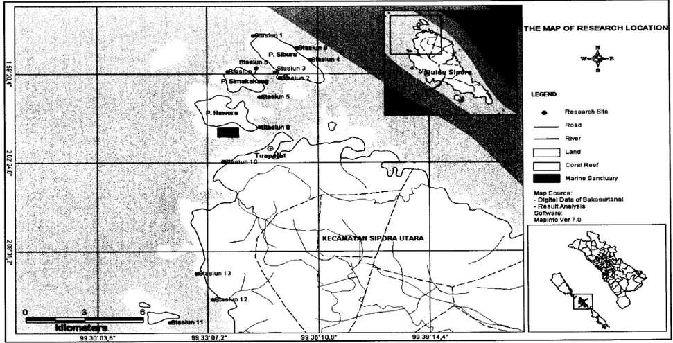
This research was done to be carried out in two months, that was, April -
Juni 2009. It will take place in coastal and small islands in Tuapijat, the regency
of Montawai Islands. The five locations are Siburu Island, Simakakang Island,
Pitotogat Island, Pitogat Besar Island and Pitogat Kecil Island.
The research stations are located in the coastal areas and small islands in
Tuapijat. The research stations of coral reef ecosystem are based on the structure
and types of the coral reefs that can be found, such as a cluster of coral
distribution, types of corals and its depth.
The research locations have been chosen after considering several things,
such as current condition and tides. Locations with strong current and high tides
are not surveyed. Coral reefs whose depth is less than 3 meters are not chosen
either. The coordinate of each location was taken and then plotted into a map
using softwere MapInfo versi 7.0. The map of the location of each research station
can be seen in the following Figure 2 (page 21).
In the northern part of Tuapejat coastal area there were 3
stations/locations. In the waters area of Siburu Island there were 5
stations/locations. In the waters are of Pitotogat (Hawera) Island there was one
research station each. The research locations/stations with their diving depth can
be seen in the following Table 1 (page 22).
The depth of diving research point to collect ecological data of coral reef
ecosystem in the research location ranging from the depth of 4 - 12.2 meter.
3.2 Materials And Methods Of Data Collection
The method used in this research was the survey method with several stages.
THE MAP OF RESURCH LOCATIO
+ Research Slte
Road
-
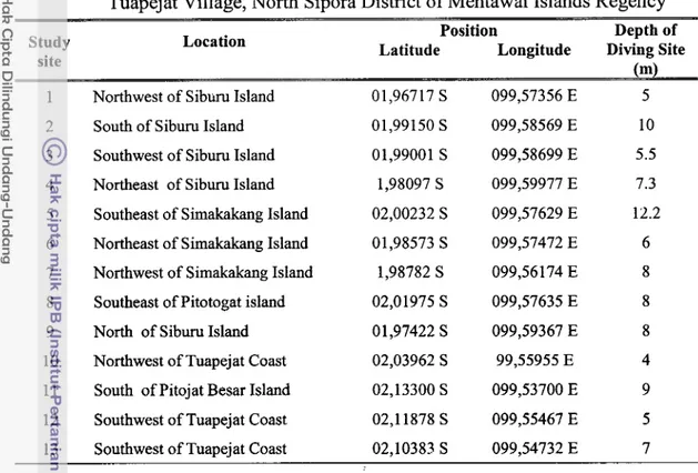
RlverTable 1 Locations, positions and diving depth in the research stations in
Tuapejat Village, North Sipora District of Mentawai Islands Regency
-
Study site
Location Position Depth of
Latitude Longitude Diving Site
1 Northwest of Siburu Island 01,96717 S 099,57356 E 5
2 South of Siburu Island 01,99150 S 099,58569 E 10
3 Southwest of Siburu Island 01,99001 S 099,58699 E 5.5
4 Northeast of Siburu Island 1,98097 S 099,59977 E 7.3
5 Southeast of Simakakang Island 02,00232 S 099,57629 E 12.2
6 Northeast of Simakakang Island 01,98573 S 099,57472 E 6
7 Northwest of Simakakang Island 1,98782 S 099,56174 E 8
8 Southeast of Pitotogat island 02,01975 S 099,57635 E 8
9 North of Siburu Island 0 1,97422 S 099,59367 E 8
10 Northwest of Tuapejat Coast 02,03962 S 99,55955 E 4
11 South of Pitojat Besar Island 02,13300 S 099,53700 E 9
12 Southwest of Tuapejat Coast 02,11878 S 099,55467 E 5
13 Southwest of Tuapeiat Coast 02,10383 S 099,54732 E 7
a. Primary Data
Ecological data include:
Water quality
Data about water quality that were needed in this research were:
-
The current speed is measured using a floating drop, with cmls unit-
The depth of research station was measured with a rope andmeasuring unit until the bottom of the waters, with a meter unit.
-
Water cleanliness was measured with measuring equipment, Secchidisc, in which the cleanliness value that has been measured was
divided by the depth and multiplied by 100 %.
-
The area od land was measured with a meter unitThe area of coral spreading was measured by determining the limiting
coordinate points with GPS, and then the area is measured with
Software Map Info versi 7.0.
Data of coral communities were collected using SCUBA divers'
equipment. In carrying out identification of coral communities the
method line intercept transect (LIT) was used with materials such as
ropes for transect line as long as 70 meters, following the English et al.
(1997) with several modifications. The length of transect line was 10
meters, and it is repeated three times. The technique to carry it out in
the field is a diver put a measuring unit (meter) as long as 70 meters
parallel to the coastal line where the position of the coast is on the left
side of the diver. Then the LIT is determined on the transect lines
0-10 m, 30-40 m, 60-70 m. Then the coral is recorded using marine
recorder carefully, which is exactly on the meter line until sentimeter.
Coral Reef Fish
Materials and equipment that were needed in this research are
almost the same as those used in collecting data of coral communities.
Observation was carried out using the underwater visual census (UVC)
method, where the fish that were ecountered, in the distance of 2.5
meters, are on the left and right sides of the transect line which is 70
meters long. The tspecies and number of individual were recorded, so
that the area that is observed per each transect is (5
x
70) = 350m2Megabenthos
These activities were carried out to calculate the number of biota
that can live associatingly and play to support the fertility of coral and
coral reefs (Manuputy et al. 2006). The equipment and materials that were used are the same as those in the LIT method.
Sampling was carried out after the LIT activities are finished,
using the reef check benthos method, that is a form of transect which is
the same length as 70 meters and the width is 1 meter to the right and 1
meter to the left of the transect line. The total area that is taken and
recorded of macrobentic biota is: (2 x 70 ) m2 = 140 m2. The biota
whose individual is recorded along the transect line are: Lobster,
Acropora spp, Pociollopra spp. or Serriatopora spp), Acanthaster
planci (sea stars), Diadema setosum (sea urchin), Pencil sea urchin,
Holothurian (sea cucumber), Giant Clam, Trochus niloticus (Lola),
Druppella (a kind of small snails that live within the mushroom corals
( Fungi spp.).
b. Secondary Data
Secondary data were collected thorugh the existing literary review,
and various reports that are obtained from various related instances and
institutions in accordance with the attributes being studies. Secondary data
were obtained from results of study or research results and activity results
in the same location, scientific publication, Governmental regulations,
central and regional, data from governmental instances, private or non-
government organizations. These secondary data consist of geophysical
data (climate, physiography, soil topography and geology), spatial data
(map) and regional demography, and other ecological data. Secondary data
are also collected throush literary study such as survey results and other
publications and available maps.
3.3 Data Analysis
Data that were collected are in the form of qualitative and quantitative
data, both from primary sources and secondary sources. Data collected from the
field were still raw. Before the tabulating process, there will be encoding and
editing which are followed by analyzing the data using a qualitative and
quantitative model.
3.3.1 Ecological Data Analysis
a. Percentage of coral Cover
The percentage of coral cover was baed on the category and percentage of
coral life form; the higher the percentage of coral cover the better the coral
the percentage of life form coral cover that were obtained based on the line
intersect transect (LIT) are calculated acording to the following equation:
Where : Ni = percentage of coral cover
li = total length of life form type i
L = transect length (70 m)
Data of coral reef cover condition that are obtained from the above
equation are then categorized according to Gomez and Yap (1988) namely:
a. 75
-
100 % : Excellent b. 50-
74.9 % : Good c. 2 5 - 4 9 . 9 % :Mediumd. 0
-
24.9 % : BadThe data are then processed using Microsof Office Excel 2007.
b. Types and and Diversity of Coral Reef Fish
Diversity of coral fish was based on the observation results that are
identified using the existing guidleinese, while the abundance of types of
coral fish is calculated using the following formula:
Edbzllukcmt
rrf
f ish species in st - r'A h d & of FfskSpecies =
Wide of tmn.ss@t
c. Megabenthos
To find out each megabhentos with the number of stion n, the abundance
per unit was calculated using the following formula:
3.3.2 Analysis of Suitability Matrix for Snorkeling, Diving and Indedex of Tourism Suitability
The marine tourism activities that are going to be developed should be in
line with the resource potential and its purpose. Every marine tourism activity has
object that that is going to be developed. Suitability analysis of utilizing marine
tourism of conservation base includes establishing a comformity matrix of every
maritime ecotourism category that exists in each observation station, weighing
and scoring, and index analysis of suitability of each marine tourism category.
Determining the criteria, giving weight and score are based on empirical
study results and justifications of the experts who are competent in the marine
ecotourism, whether it is written or oral. The initial step that is carried out is
establishing a criteria matrix of utilizing suitability to make easy the weighting
and scoring that contains information on parameter, weight, level of suitability
and score. The types of maritim tourism that are suitable in the coral reef
ecosystem are snorkeling and diving tourisms.
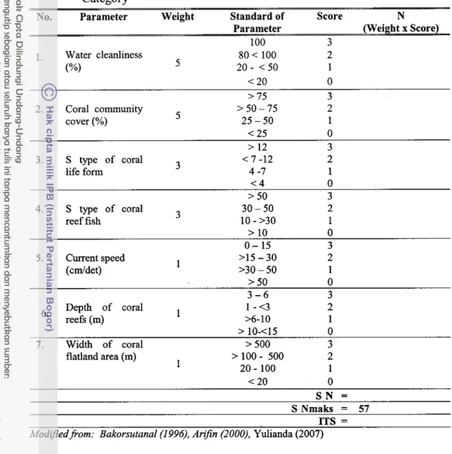
a. Suitability matrix for Snorkeling
The marine tourism suitability of snorkeling tourism category considers
seven parameters and four judgment classification. Parameter of snorkeling
tourism suitability are, among others, water cleanliness, coral cover, life form
coral types, coral fish, current speed, depth of coral reefs, width of the coral
flatland (Yulianda 2007) such as shown in Table 2 below (page 27).
Then determining the indext of utilization suitability for snorkeling tourism
was using the following formula:
ITS = ? [ NiJNmaks] x 100 %
Where:
ITS = Index of Tourism Suitability
S Ni = value of parameter i (Weight x Score)
S Nmax = maximum value of tourism category
Determining the suitability level of the snorkeling tourism activities is as follows
(results of modification):
S1 = very suitable, with ITS 83 - 100 %
S2 = Suitable,with ITS 50
-
< 83 %Table 2 Suitability Matrix for the Area of maritime Tourism of Snorkeling Category
-
-
No. Parameter Weight Standard of Score N
Parameter (Weight x Score)
-
100 3
1. Water cleanliness 80 < 100 2
("/.I
5 20 - < 50 1< 20 0
> 75 3
2. Coral community
5 >50-75 2
cover (%) 25 - 50 1
< 25 0
> 12 3 <