Proceedings of
the 34
th
Asian Conference on
Remote Sensing 2013
Bali – Indonesia, October 20 -24, 2013
Indonesian Remote Sensing Society
and
Editorial Boards:
Gatot H. Pramono
Dadan Ramdani
Baba Barus
Reiza M. Ariansyah
Reviewers:
Baba Barus (IPB)
Gatot H. Pramono (BIG)
Fahmi Amhar (BIG),
A. Anugrahadi (Univ Trisakti)
Albertus Deliar (ITB)
M. Rokhis Khomarudin (LAPAN)
Wikanti A (LAPAN)
Projo Danoedoro (UGM)
Mulyanto Darmawan( BIG)
Muhammad Evri (BPPT)
Yudi Setiawan (IPB)
Chusnul Trijudianto (LAPAN)
Dadan Ramdani (BIG)
Proceedings of the 34
thAsian Conference on Remote Sensing 2013
ISBN: 978-602-9439-33-5
Indonesian Remote Sensing Society
Masyarakat Ahli Penginderaan Jarak Jauh [MAPIN] Jl. Raya Jakarta – Bogor Km 46 Cibinong, Indonesia Phone: +62-(0)-812-110-3127
LANDUSE CHANGE DURING A DECADE AS DETERMINED BY LANDSAT IMAGERY OF A RICE PRODUCTION REGION AND ITS IMPLICATION TO
REGIONAL CONTRIBUTION TO RICE SELF SUFFICIENCY: CASE STUDY OF KARAWANG REGENCY, WEST JAVA, INDONESIA
Widiatmaka1*, Wiwin Ambarwulan2, Khursatul Munibah1
1
Department of Soil Sciences, Faculty of Agriculture, Bogor Agricultural University, Jalan Meranti, Kampus IPB Darmaga, Bogor, INDONESIA
2
Geospatial Information Agency, Jalan Raya Jakarta-Bogor KM 46, Cibinong, INDONESIA
*Corresponding author: [email protected]; [email protected]
ABSTRACT
Karawang Regency, West Java, is one of the region that contribute to the national food supply, due to its high soil fertility and high extent of paddy field area. However, dynamics of land use and land cover change in this region are estimated high because of its proximity to the country’s capital. This dynamics has led to changes in rice production. This research was conducted to study the changes in land use and land cover in a decade during the period of 2000 – 2011 and its relation to rice production. Land use and land cover changes were identified using Landsat TM imagery of 2000, 2003, 2006, 2009 and 2011. Production and productivity of rice were obtained from statistical data of Karawang Regency, year 2000-2011. The results showed that in the period between 2000 and 2011,
paddy fields area identified in the image decreased from 120,865 Ha in year 2000 to an area of 95,926
Ha in 2011. The most extensive land use and land cover change was change from paddy fields to settlements. The settlement area increase from 20,588 Ha in 2000 to 38,025 Ha in 2011. Regarding the pattern of overall land use and land cover change, it is expected that the most part of settlements increasing area was originated from paddy field area. The rate of such paddy field conversion in Karawang Regency during 2000 – 2011 was calculated at 1,88%/year. This decreasing paddy field area has resulted the decreasing the contribution of Karawang Regency to national food security. The decrease of regional contribution was accounted by 10% over the last 11 years. It is required the serious efforts from the government, either in the context of decreasing the continual paddy field conversion, as well as in the context of further optimizing Karawang Regency ability to still be able to contribute to the national food security.
Keywords: Paddy fields, land conversion, land productivity
INTRODUCTION
One of the main problem of Indonesia is the high dependence of food production to the island of Java. As an illustration, in 2011, Indonesia produced 65,756,904 tonnes of rice, which is produced from paddy field area of 13,203,643 hectares, or with productivity average of 49.80 kw/Ha (BPS, 2012). Java island, which covers only 7% of Indonesia's land area, contribute 34,404,557 tons of rice production, or 52.32% of the national rice production. Rice production is obtained from Java paddy field area of 6,165,079 hectares, or 46.69% of the national paddy field area. These facts show the national food security dependence on Java island. Dependence on rice production to the Java island seems due to two things. First, the paddy field area in Java island is largely more dominant among the other islands. Secondly, the productivity of Java’s paddy field is much higher than the other islands’ paddy field. As an illustration, average productivity of paddy field in Java is 54.80 kw/ha, was higher than the productivity of paddy field in outside of Java, where productivity average is only 41.83 kw/ha. Among all province in Indonesia, highest productivity is achieved by the Province of West Java, which have an average yields of 59.22 kw/ha. Compare this facts with the productivity of Central Kalimantan Province, which only atteint at a productivity of 28.49 kw/ha, or Bangka-Belitung Province, which has paddy field productivity average at only 28.71 kw/ha (BPS, 2012).
The high dependence on the production of Java island implies that paddy field conversion in Java island will have a significant impact to national food security. First, the paddy fields that have been
Proceedings of ACRS 2013
converted into non-agricultural uses –as the most case in Java- are irreversible (Irawan, 2005; Iqbal and Sumaryanto, 2007). Secondly, efforts to make new paddy fields requiring long periods of time to atteint the same productivity. At least it takes about 10 years for new paddy fields to atteint an optimal production (Hardjowigeno & Widiatmaka, 2007). Third, land resources which can be used to extent the paddy fields become more limited in the future.
Karawang Regency is one of the areas in West Java Province which has long been known as a center of food production, especially rice. However, its geographic location as a hinterland position of the nation's capital, Jakarta, has increasingly threatened its position as food production centers. The agricultural sector, which have a lower land rent, is predicted will be less able to compete in terms of land use with the industrial sector which grows rapidly, to this fact added by the increasing need for housing, infrastructure and industrial area.
Facts that Karawang Regency has traditionally been know as a center of rice production can be seen from some of the data. Based on Rice Development Road-map of Karawang Regency Year 2007, it is stated that since 2000, rice production of Karawang Regency was always above 1 million tonnes
(Widiatmaka et al., 2007). With a population of 2,070,329 in 2007, the rice production always gives a
surplus production that contributes to regional food self-sufficiency. This means that Karawang Regency is one of substantial area that contribute to the national rice sufficiency. There is a significant contribution from the centers of rice fields in Karawang Regency against the surrounding region, including to nation's capital.
Correspondingly with population growth, rising population incomes, and increasing economic activity, the needs of food increase. On the other hand, the demand for land is also increasing, driven by a variety of development activities related to the role of Karawang as Jakarta’s buffer areas. This has led the increasing conversion of agricultural land to non-agricultural uses such as residential, industrial and other modern infrastructure. This of course has led to a decline in rice production capacity, especially with the diminishing irrigated paddy fields which are the main source of rice production. The irrigated paddy fields contribute so far for more than 90% of rice production.
The purpose of this study is to analyze trend of land use and land cover change, especially paddy field in Karawang Regency and analyze the implication of such land use change in term of regional ability to contribute the national rice production.
MATERIALS AND METHODS
The study area, Karawang Regency, West Java, Indonesia, is located between 107º02` and 107º40`E, 5º56` – 6º34`S in the northwest part of Java Island, Indonesia (Figure 1) and covers an area
about 1,753.27 km2, or 3,73 percent from West Java Province area. The study area has a tropical
monsoon type of climate with annual precipitation at around 3.200 mm/year (BPS, 2010), most of which occurs from November to May. The mean annual temperature is about 27°C (BPS, 2010). Elevation in the study area varies from 0 to 200 m above sea level and generally decreases from south to north. Agriculture is the main land use in the area and sparse forest lands and shrubs are the other land cover types. The major agricultural crops are rice, maize, soybean and green beans.
Change of land use and land cover of the study area was first analyzed. The image used for this study include Landsat 7 ETM+ (recording of September 14, 2000 and Avril 16, 2003), Landsat 5 TM (recording of October 1, 2006; August 6, 2009 and September 13, 2011). The supervised classification was conducted, followed by field checking for the image of 2011. The image classification was done using ERDAS Imagine software. The Land use and land cover changes have been analyzed using ArcGIS software. Statistical data from Karawang Regency in Figures (BPS, 2001 to 2012) were then used to analysis by confronting statistical with image data.
Proceedings of ACRS 2013
Figure 1. Research Area
RESULT AND DISCUSSION
Land use and Land Cover Changes.
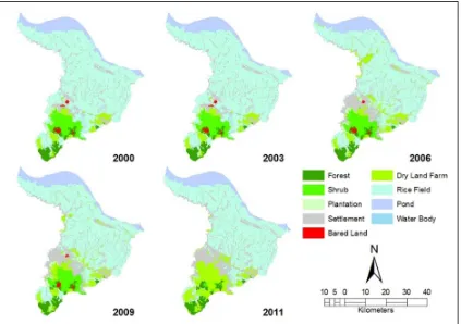
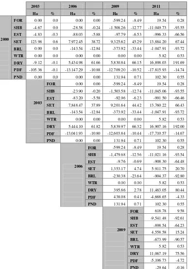
The spatial distribution of land use and land cover changes within Karawang Regency from 2000 to 2011 is presented in Figure 2. Table 1 shows overall land use and land cover changes among the four years analysis.
Figure 1. Land use and land cover changes of Karawang Regency 2000 – 2011 Proceedings of ACRS 2013
Table 1. Matrix of landuse and land cover changes 2000 – 2011, Karawang Regency body; DRY: dry land farming; PDF: paddy field; PND: ponds
Proceedings of ACRS 2013
Land use and land cover of Karawang Regency consists of forest, shrubs, plantation estate, settlements, barre land, water body, dryland farming, paddy fields and ponds. According to it’s dominance area, generally from all year of image observation, paddy field is the dominant land use. Paddy field is distributed in the middle region to the north region. Approaching the northern coast (Java Sea), such paddy field dominance was replaced by wetland ponds. Other land use that is large enough is settlement, which occupies the city, in the southern part of Karawang Regency.
In term of land use and land cover change, from 2000 to 2003 the landscape was relatively static with small scale changes in all informational classes. The greatest land use and land cover changes
occurred after 2003, with high loss in paddy field and high increase in settlement. Paddy fields area
reduced, from an area of 120,865 Ha in 2000 to 95,926 Ha in 2011. Part of the region where paddy field was reduced was especially the region close to urban areas. In timeframe terms, the paddy field decrease is only 105 ha during 2000 to 2003, while from 2003 to 2006, 2006 to 2009 and 2009 to 2011, the decrease that occurs were 13.041 ha, 438 ha and 5.106 ha each. In total, during 11 years in the period of 2000 to 2011, the decrease of paddy field area was 24,939 Ha, or with an average of 2,267 hectares per year, or 1.88% per year. This amount of land conversion complete some results obtained from previous studies. According to Sumaryanto & Suhaeti (1997), the paddy fields conversion in West Java during the period of 1987 – 1991 were totally 37,033 Ha, or with the rate of 7,046 Ha/year. According to Pakpahan et al. (1994) and Sumaryanto et al. (1995) (In Sumaryanto et
al., 2001), paddy field conversion in West Java in the period of 1987-1991 was 37,000 Ha, in Central
Java (1981-1986) was 40,300 Ha, in Yogyakarta (1986-1990) was 2,900 Ha, and in East Java (1987-1993) was 58,000 Ha. Thus the average area of rice fields in Java that converted was about 22,200 Ha/year.
Another land use and land cover which were also decrease its extent were shrubs, plantations and barre land. Shrubs decrease from 11,800 Ha in 2000 to 761 Ha in 2011. Meanwhile, the estate plantation decrease from 1,496 Ha in 2000 to 500 Ha in 2011. Barre land decrease constantly, from 1,118 Ha in 2000 to 70 Ha in 2011. Some other land use and land cover such as forests, water bodies and ponds have a relatively constants.
Land use which significantly increased is settlements. The area of settlements increased, from 20,588 Ha in 2000 to 38.025 Ha in 2011. In other words, there was an increase of 17,436 Ha during 11 years.
Regarding to the fact of decreasing paddy field, the constant area of several other landuse type, it can be stated that the increasing area of settlement was largely derived from paddy fields. Even, as the paddy field is not reduced as high as the increasing settlement, it is possible that some of settlement was derived from shrub, barre land and plantations.
Implications Against Contribution Karawang Regency to National Rice Self-Sufficiency
Table 2 presents the calculation of contribution of Karawang Regency to provide a surplus for the surrounding area, including the nation's capital, Jakarta. Some explanation is required for reading this table. Paddy field area presented in such table are the result of image interpretation analysis for year 2000, 2003, 2006, 2009 and 2011. Data listed in the table for other years (2001, 2002, 2004, 2005, 2007, 2008 and 2010) are extrapolation data, taken from the rate of conversion for 11 years, or the average conversion 1,88% per year. Productivity and planting index listed in the table are taken from statistical data of Karawang Regency in Figures (BPS 2001 - 2012). From such statistical data, it could be stated that the average productivity of paddy field in Karawang Regency increase substantially, from 5.90 tonnes/Ha in 2000 to 7:41 tonnes/Ha in 2011. There are many factors that lead to increasing productivity, among others the adoption of technology (fertilizers, insecticides, superior seeds etc.), added with improvement condition of agricultural social factors such as farmers counseling and farmer groups and others. The value of planting index, which relatively constants reflects that the irrigation intensification was not optimally developped yet.
The value of production in the table is calculated, only from irrigated paddy fields. In fact, according statistical data of Karawang Regency, paddy fields could be classified as technical irrigated, semi-technical irrigated, simple irrigated and rainfed paddy field. Based on the statistical data for 11 years, the composition of such various irrigation state is relatively constant, the technical irrigated paddy field constitute 87.3% of the total area of rice fields (85.97% in 2000 and 87.59% in 2011). Hence, the value irrigated paddy field was used by the correction value.
Proceedings of ACRS 2013
Meanwhile, the data of population is statistically real data. Based on these data, the population of Karawang Regency has grown, from 1,765,945 people in 2000, to 2,187,861 in 2011. Demand for rice is calculated based on per capita needs. Requirement of rice per capita was assumed at 141 kg year-1, which consists of direct household consumpsion of 120 kg and 21 kg as needs of food processing industries (Balitbangtan, 2005). To this needs, it should be added the industrial demand, which was accounted for 23.5% of domestic demand and 10% of other demand (stock). With such assumptions of calculations, the results of the calculation are presented in Table 2.
Table 2. Calculated surplus of rice from paddy field area of Karawang Regency, Indonesia
Year
Landsat image interpretation; 2Landsat image interpretation with field checking; 3Extrapolation value from rate of conversion during 10 years (2000-2011); 4Statistical data; 5Calculated from image interpretation and statistical data.
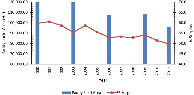
Figure 2. Evolution of paddy field area and surplus of rice production of Karawang Regency during 2000 – 2011
From Figure 2, it can be stated that the surplus of production that can be donated Karawang Regency out from the region decrease continually in the period of 2000 to 2011. If in the year 2000 Karawang Regency can contribute 60% (or more precisely 59.75%) of its production to be share and exported out from the region, then in 2011, a surplus that can be shared out from the region was only about 50% (49.82% to be exact), or a decrease of 10%. This decreasing contribution is relatively small compared to the decrease in paddy field area, which in the last 11 years reach 20.63%. This decrease was offset by a significant increase in productivity. Nevertheless, the fact remains alarming. Rice productivity which is currently 7.4 tonnes/Ha was estimated to be more difficult to be improved, although it is still possible with the continual research and development to obtain new varieties, new
method of fertilization and pest control, however the effort will certainly more difficult. Various other ways need to be done, such as increasing planting index by increasing the quality of irrigation, water use efficiency and increasing effort of seperior seed utilization. On the other hand, the effort in diminishing rice consumption should be continuously done. Besides such efforts, the very important effort to be done is stopping the continued decrease of paddy field area. If the phenomenon of decreasing paddy field area as described in Karawang Regency occurs in all rice production centers in Java island, it is worried that national food security will be threatened. In this context, the application of Law No. 41 of 2009 on Sustainable Land for Agriculture Food and regulations for its implementation needs to be implemented.
CONCLUSION AND RECOMENDATION
From this research, it can be conluded that in the period during 2000 - 2011, there was change in land use and land cover in Karawang Regency, Indonesia, which are quite intensive. The land use which increase significantly is settlements. Settlements grew from Ha in 2000 to in 2011. Land use and land cover which were significantly reduced were paddy field, from 120,865.82 in the year 2000
to 95,926.68 in the year 2011. Regarding the pattern of overall land use and land cover change, it is
expected that the most part of settlements increasing area was originated from paddy field area which are converted to residential area. The rate of such paddy field conversion in Karawang was calculated at 2,267 ha/year or 1.88% per year. This decreasing of paddy field has resulted in the reduction of contribution of Karawang Regency to national food security. The reduction was accounted by 10% over the last 11 years.
It is required the serious efforts from the government, either in the context of decreasing the continual rice field conversion, as well as in the context of further optimizing Karawang regency ability to still be able to contribute to the national food security.
The facts described in this paper is expected occured in almost all food production centers in Java. The pression of land use change from agricultural land into other use in other sector in the future will increase. For that, the effort as advised at precedent paragraph needs to be done thoroughly, to secure national food security.
ACKNOWLEDGEMENT
The authors would like to acknowledge the financement by Program of BOPTN (Biaya Operasional Perguruan Tinggi Negeri), Bogor Agricultural University
REFERENCE
[Balitbangtan] Badan Penelitian danPengembangan Pertanian. 2005. Prospek dan Arah Pengembangan Agribisnis Padi. Badan Litbang Pertanian. Jakarta.
[BPS] Badan Pusat Statistik. 2001 to 2012. Kabupaten Karawang dalam Angka 2000 to 2011. Badan Pusat Statistik. Karawang.
[BPS] Badan Pusat Statistik. 2012. Tabel Luas Panen- Produktivitas- Produksi Tanaman Padi Seluruh Provinsi. http:// www.bps.go.id/tnmn_pgn.php?kat=3
Hardjowigeno, S., Widiatmaka. 2007. Evaluasi Lahan dan Perencanaan Tataguna Lahan. Gadjahmada University Press. Yogyakarta.
Iqbal, M., Sumaryanto. 2007. Strategi Pengendalian Alih Fungsi Lahan Pertanian
Bertumpu Pada Partisipasi Masyarakat. Jurnal Analisis Kebijakan Pertanian. Volume 5 No. 2, Juni 2007 : 167-182. Bogor.Fun, 1996.
Irawan, B. 2005. Konversi Lahan Sawah: Potensi Dampak, Pola Pemanfaatannya, dan Faktor Determinan. Forum Penelitian Agro Ekonomi. Volume 23 No. 1, Juli 2005 : 1 – 18
Sumaryanto and R. N. Suhaeti. 1997. Assesment of Losses Related to Irrigated Lowland Conversion. Indonesian Agricultural Research & Development Journal 19 (1&2): 20 – 28.
Sumaryanto, S. Friyatno, B. Irawan. 2001 . Konversi Lahan Sawah Ke Penggunaan Nonpertanian dan
Dampak Negatifnya. Prosiding Seminar Nasional Multifungsi Lahan Sawah.
balittanah.litbang.deptan.go.id/.../prosiding/mflp2001/sumaryanto.pdf.
Widiatmaka, U. Usman. N. Ramli. 2007. Roadmap Padi Kabupaten Karawang. Dinas Pertanian Tanaman Pangan, Kehutanan dan Perkebunan Kabupaten Karawang.
Proceedings of ACRS 2013