Project Reference Number:
CIA2009-04-Gaol
Final Report submitted to APN
PROJECT LEADER
Dr. Jonson Lumban Gaol
Department of Marine Science and Technology Bogor Agricultural University Bogor, Indonesia
PROJECT COLLABORATORS
Dr. Jonson Lumban Gaol, Department of Marine Science and Technology, Bogor Agricultural University. Indonesia, [email protected]
Dr. Robert R. Leben, Colorado Center for Astrodynamics (CCAR), Colorado Univ. USA, [email protected]
Dr. Parluhutan Manurung, National Coordinating Agency for Surveys and Mapping, Indonesia, [email protected]
Dr. Bidawi Hasyim, National Agency for Aerospace and Atmospheric, Indonesia, [email protected]
OVERVIEW OF PROJECT WORK AND OUTCOMES
Non-technical summary
This Project consists of training and workshop activities designed to enhance the capabilities of young scientists in Indonesia in terms of processing and analysis sea level data from both in-situ and satellite in time series. Each participant trained to analyze the trend of sea level rise (SLR) in the area of each participant. Furthermore, sea level data used for analyzing and simulating coastal inundation due to sea levels rise 20 to 50 years in the future and also analyze the vulnerability of the coast due to SLR. Trainees conduct a case study the impact of SLR on coastal inundation. The workshop involves training participants and policy makers to equate perceptions and to discuss adaptation and mitigation activities to overcome SLR. After the training and workshop, the participant from local institution has also planned adaptation activities such as mangrove planting project in 2011 and prevent reduce of erosion due to SLR, collaborated with committee of APN-CIA2009-04-Gaol.
Objectives
The main objectives of the project were:
1. To raise awareness of Indonesian local scientists and policy makers on the SLR impacts in coastal zone.
2. To enhance the capability of Indonesian local scientists to process and analysis of SLR data and its impact on coastal vulnerability in local area.
3. To equate the perception among Indonesian scientists and policy makers on the SLR impacts in coastal zone for planning the mitigation and adaptation activities.
Amount received and number years supported
The Grant awarded to this project was: US$ 28,500 for 1 Year 2009/2010
Activity undertaken
1. To invite the training and workshop participants from all over Indonesia.
2. Preparing training activities by inviting instructors and developing training modules.
3. Organization of a 10-day training in In-Situ/Satellite SLR Measurement.
4. Organization of a 3-day workshop Climate change impact on coastal zones and fisheries.
5. Conducting research on the impact of SLR on coastal zone.
6. Dissemination impacts of SLR in Indonesia with a presentation of activities by the APN CIA2009-04-Gaol at national and international symposium.
7. Preparation of training and workshop proceedings.
Results
2. Training module of data processing and analysis coastal vulnerability index using Geographical Information System (GIS).
3. Training activities for 10 days has been conducted well with involving 10 lecturers, 10 instructors and 30 participants.
4. Proceedings consisted of papers of the case studies on the impact of SLR in some places in Indonesia.
5. A 3-day workshop has been organized to discuss the impact of global climate change on coastal zone and fisheries with invited national policy makers who have responsibility on mitigation and adaptation to climate change.
Relevance to APN’s Science and Policy Agenda
The project is in line with APN’s Third Strategic Plan as it encompasses the evaluation of coastal and marine changes in South East Asia resulting from global warming. One focus of the SCBCIA program is to improve scientific capabilities to assess the impact and vulnerability to climate change area to reduce risks especially in developing countries like Indonesia. Global warming caused negative impacts on coastal communities and small islands. Therefore, this training is very important to improve the scientific capability of Indonesian young scientists.
Indonesia as an archipelagic country with a great distance between islands consists of 33 province, where the scientific capabilities of each local community is different. Through the training of participants representing 33 provinces in Indonesia will ensure equitable distribution and increase the scientific capabilities particularly to examine the impact and vulnerability of climate change on coastal area. Furthermore they are able to choose adaptation strategies to reduce the risk. The project increased capacity building for sea level is a part of various international programs such as the World Climate Research Program, Intergovernmental Oceanographic Commission and the Global Sea Level Observing System. In these programs, Indonesian institutions such as BAKOSURTANAL also play an active role.
Self evaluation
This project has been executed according to our plan. Based on a questionnaire that have distributed to participants, all of them were satisfied with the training materials that have been gave by instructors. Generally, before the training the participants don’t know how to determine the trend of SLR from in situ and satellites data. Through this training they have been able to determine the trend of SLR in certain areas, particularly from satellite data. After the training, the participants also were able to analyze the inundation areas and the coastal vulnerability with Geographic Information System analysis. The result of the training and workshop have presented in International and national symposium.
Potential for further work
so that people will be more careful and keep the environment act to reduce climate change impacts.
At the workshop, invited speakers from government agencies such as the Ministry of Marine Affairs and Fisheries of Indonesia (MAFI), Meteorology Climatology and Geophysical Agency of Indonesia (MCGA), Indonesia Institute of Science (IIS), and Indonesia Climate Change Trust Fund (ICCTF), the National Development Planning Agency have presented a program on climate change mitigation and adaptation. MAFI had planned mitigation and adaptation projects, particularly for coastal areas with programs such as planting mangroves, building houses on stilts to residents on the beach where local governments can be involved in this project. MCGA will develop a program to provide information specifically for the maritime climate. IIS planned research program with the topic of global climate change impact studies on the vulnerability of coastal and fisheries. ICCTF provides an opportunity to finance mitigation and adaptation field of marine and fisheries activities.
The result of the workshop indicated the same perception of the participants and policy makers to give more attention to adaptation and mitigation of global climate change impacts, particularly impacts of SLR on coastal and fisheries activities. Some local government has also planned mangrove planting project in the coastal region in collaboration with the project committee APN (SCBIA-2009-Gaol).
Publications/Presentations
Gaol J.L., R.I Arhatin, N.M.Natih, A.W. Rusdiastuti, R. Pasaribu. Sea Level Rise and Its Impact on Indonesian Coastal Area. In Proceedings National Marine and Fisheries Symposium, Jakarta 3-4 December 2010.
Gaol J.L, R.R. Leben, P. Manurung, B. Hasyim. Increasing Capacity of Local Scientists for Climate Change Impact & Vulnerability Assessment on Indonesia Archipelagos: Training in In-Situ/Satellite Sea Level Measurement. Poster Presentation. MST Workshop. Bogor-Indonesia & PORSEC Taiwan.
Leben, R. R and J. L. Gaol. Training Workshop on Vulnerability Assessment of The Indonesian Archipelago to Climate Change. Presented at 2010 Ocean Surface Topography Science Team (OST-ST) Meeting in Lisbon Portugal.
Acknowledgments
TECHNICAL REPORT
Preface
Indonesia has 1,700 islands and predicted more than 2000 small islands will be lost due to the SLR (SLR) impact. Therefore, monitoring of SLR in Indonesia coastal waters is very important for assessing the impact on coastal area. The objective of project is to enhance the knowledge of Indonesian scientist for SLR monitoring and coastal vulnerability analysis. Our activities focused on the training in in-situ and satellite SLR measurement, field study and workshop. To undertake the project, scientist and policy makers from Indonesia, and USA, and Japan have collaborated. The project has trained Indonesian local scientists and conducted research in local area.
Table of Contents
1. Introduction ………...………...………...………..… 1.1 Background Information ……….….……… 1.2 Scientific Significant ………..….………..……….…… 1.3 Objective ………..………..………...……..
2. Methodology ……….………..……….... 2.1 In-Situ Sea Level Data ………...………...………... 2.2 Satellite Sea Level Data ………...…… 2.3 Coastal Inundation and Vulnerability Analysis using GIS……….
3. Result & Discussion ……….. 3.1 Training Activities ………..………..…... 3.2 Field Study in each area of participant ……….…..…… 3.2 Workshop Activities ………..………..
4. Conclusion ………..……..
5. Future Direction ………...………...
Reference ……….……….
Appendices……… 7 7 7 7
8 8 8 8
8 8 25 26
27
27
28
1. Introduction
1.1 Background Information
Indonesia is an archipelagic country consisting of nearly 17,000 islands with a total coast line length exceeding of 81,000 km. The country borders two oceans with the sea water flows from Pacific to Indian Ocean passing the archipelago via the so called Indonesian water through flow. Indonesian sea waters have large variations of tidal regime, strong tides, and sea level rise (SLR) (Manurung, 2004). Ministry of Fisheries and Marine Affair of Indonesia predicted that more than 2000 small islands will be lost due to the impact of SLR. SLR is one of the impacts of global warming and will cause inundation of many small islands and coastal in Indonesia (BAAPENAS, 2010). Therefore, these islands will suffer from SLR evidence.
Meanwhile, capacity of human resources and public awareness of SLR is still low. For example, a household survey was carried out to determine the awareness level of farmer on SLR and its effect on the agricultural lands in South Kalimantan showed that only 35 percent of farmers are aware of the impact of SLR (Saidy and Aziz, 2009). Therefore, measurement SLR, assessing its effect and possibly mitigating and adapting in coastal areas is very important for Indonesia country.
1.2 Scientific significance
Indonesia is a developing country still lacks facilities, human resources and technology, specifically in the field of sea level measurement and GIS analysis for assessing coastal vulnerability of SLR. However, the distribution of the existing National Sea Level Monitoring Network consisting of 60 stations is considered less adequate to represent a better understanding of tidal characteristics and sea level along the country coast line. Assuming one tidal station represent for a tidal regime of about 100 km coast line length, an idealistic number of permanent tidal stations for the whole country should be simply consisted of about 810 stations (Manurung, 2004).
Considering the difficulties to obtain SLR from in situ measurement which is expensive, remote sensing method is a good choice for estimating SLR. Therefore, we propose training and workshops to improve the scientific capability of young Indonesian scientists to measure and assess the impact SLR and vulnerability of coastal areas due to SLR.
1.3 Objective
2. Methodology
The project is conducted for one year, divided into three stages i.e., training activities, field studies and workshops. Training activities carried out during 8 days, field studies during 4 months at each location of participant, and 3-day workshop.
Training is done by inviting young scientists from related institutions and university that represent the entire Indonesian archipelago. Preparation of training we invited two lecturers from the University of Colorado, USA and University of Hokkaido Japan, as well as 10 lecturer from Indonesia, and 10 instructors. For the activity of training, it was prepared training module of the satellite SLR data processing, module of analysis of coastal inundation, and module of coastal vulnerability by using Geographic Information System.
2.1 In-Situ Sea Level Data
For this training we used tide data obtained from Coordinating Agency for Surveys and Mapping, Indonesia (BAKOSURTANAL). Participants were trained how to obtain and analyze tide data and calculated SLR using Tide Analysis and Prediction Software which have been developed BAKOSURTANAL.
2.2 Sea level data from Satellite
Sea Level data processing of satellite used altimeter data from AVISO and CCAR (1993-200). Those data were processed and analyzed by using Matlab software which has been prepared by Dr. Robert Leben for Training Modules.
2.3 Coastal Inundation and Vulnerability analysis using GIS
Coastal inundation analysis was used to map the coastal inundation area due to SLR 20-50 year later. A coastal vulnerability index (CVI) was used to map the relative vulnerability of the coast to future SLR. The CVI ranks the following in terms of their physical contribution to SLR related coastal change: geomorphology, regional coastal slope, rate of relative sea-level rise, historical shoreline change rates, mean tidal range and mean significant wave height (Gornizt et al., 1994). Processing and analyzing data for coastal inundation and vulnerability were prepared in Training Module.
3. Results & Discussion
Training activities, field studies and workshops have been conducted and the results will be explained as follows:
3.1. Training Activities
(a)
Class/Lecture
presentation topics related to SLR. The schedule of the lectures are given in the appendix and at www.apncia2009gaol.com. All ppt’s of the lectures can be downloaded. Here we give a short characterization of the contents of lectures.
1. Dr. Alan Koropitan (Department of Marine science Technology, Bogor Agricultural Univ.)
Title: Climate Change: Before, Now and Then.
This presentation describes the climate change reality, how do we deal with future climate? Have we prepared with a variety of shocks that occurred in the climate system? (facts of current and future scenarios, smooth and abrupt changes). The lecture also described an example case study about the effect of climate change on the condition of Java Sea waters.
2. Dr. Parluhutan Manurung
Title : Sea Level Monitoring In Indonesia.
This lecture explained the Sea Level Dynamics, Tidal Description, How to observe sea level?, About Indonesian Sea Level Network, InaTEWS, Sea Level Change, Other Applications. Exercise: Sea Level Data Processing. 3. Dr. Ivonne M. Rajawane (Oceanography Study Program, Bandung Institute
Technology)
Title: Vulnerability Assessment due to Sea Level Rises
This lecture described the definition of vulnerability, Risk and Hazard, Exposure, Sensitivity, Adaptation and Capacity, Resilience, Socioeconomic impact SLR, Adaptation Method, and Example Approach to Adaptation Measurement.
4. Dr. Bisman Nababan (Department of Marine Science Technology, Bogor Agri. Univ.)
Title: Coastal Classification Geomorphology using Remote Sensing and GIS. This lecture explains how to process satellite data to produce coastal geomorphology map which is one of the data used to assess the vulnerability of coast.
5. Dr. Mulia Purba (Department of Marine Science Technology, Bogor Agri. Univ.)
Title: Coastal Dynamic: Coastal Line Changes
This lecture explains coastal dynamic such as how the wind generates waves, wave propagation in the sea towards coast. How the wave and propagation resulted in erosion and accretion and causing shoreline change. The presentation also described the case study model of shoreline change in South Sulawesi, Indonesia.
6. Dr. I Wayan Nurjaya (Department of Marine Science Technology, Bogor Agri. Univ.)
Title: Ocean Waves, and Coastal Vulnerability
This lecture explains how the waves occurred at sea, the types of waves, wave energy, how to measure wave height, the process of coastal damage due to wave such as abrasion and accretion. The presentation also described the effect of coastal wave on costal vulnerability.
7. Dr. Jonson L. Gaol (Department of Marine Science Technology, Bogor Agri. Univ.)
Title: Assessment of Coastal Vulnerability using GIS
8. Prof. Dr. Seichi Saitoh (Center for Sustainability of Science, Hokkaido University)
Title: An Operational use of Remote Sensing and Marine-GIS for Assessing the Climate Change Impact on Fisheries and Aqua Culture.
This lectures explained challenge for future fisheries management; case study application of remote sensing and marine-GIS for assessing the effect of global warming on Japanese Aquaculture Scallop and case study using VMS and satellite information for skipjack tuna fisheries management.
9. Dr. Henry Manik (Department of Marine science Technology, Bogor Agri. Univ.)
Title: Matlab for Oceanography Data Analysis and Image Processing
This lecture explained the basic of Matlab software and application for data processing.
10. Dr. Robert R. Leben. (Colorado Center for Astrodynamics Research Center, Colorado University, USA)
Dr. Robert Leben has given some topics of lecture as follows: (a) Brief History of Satellite Altimetry, (b) Altimeter Range Corrections, (c) Mesoscale Eddies and the Gulf of Mexico, (d) Kelvin and Rossby Waves, (e) Sea Level Reconstruction using Tide Gauges and Satellite Altimetry, (e) Large Scale Coupled Ocean Atmosphere Oscillations
B. Laboratory Work
(1) In situ Sea Level Data Collection Processing and Analysis
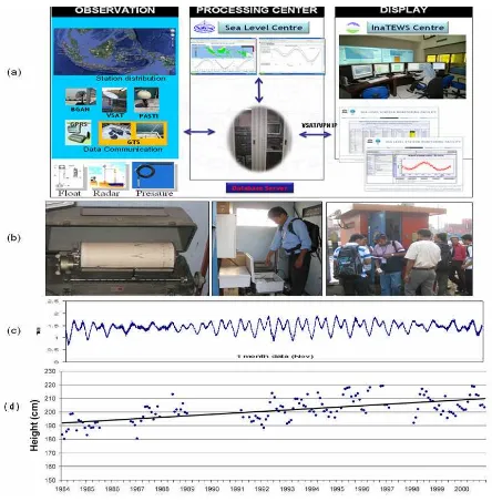
Figure 1. (a) Sea Level data collecting, processing, and analyzing system in Indonesia (b) Training participant in Jakarta field Tide Gauge (c) Example of sea Level data recording (d) SLR trend in Jakarta Coastal from insitu measurement (tide gauge).
(2) Satellite Sea Level Data Collection, Processing, and Analysis
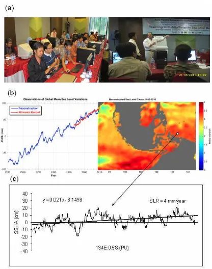
Figure 2. (a) APN training participant are processing satellite sea level data and Dr. Robert Leben was teaching sea level data processing (b) Reconstruction global and Indonesian mean sea level (c) Example of sea level rise trend from satellite in north of Papua, Indonesia.
(3) Coastal Inundation analysis
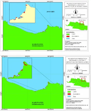
The Results of inundation analysis for 20 years and 50 years later show that all Indramayu coasts will be suffer by SLR impact. However, coast area of some subdistricts, i.e. Sukra, Losarang, Cantigi, Sindang and Indramayu are dominant to be inundated. The coastal area impact of inundation prediction on 20 years later will reach 331.9393 ha, and inundation will increase on 50 year later by
446,9281 ha. Therefore, it will be decreasing of width of land. For the case of Indramayu coast, decrease width of land will also be aggravated by coastal erosion. Land erosion process and inundation by SLR will easily happen on Indramayu coast, because the coast geomorphology is sandy land that can easily eroded and will be fast inundated (Figure 4).
Figure 3. Inundation prediction impact SLR on 20 and 50 years later impact of SLR in Indramayu District.
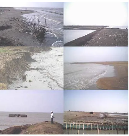
Figure 4. Coastal
erosion and fish pond in Indramayu District impact SLR(4)
Coastal Vulnerability analysis using GIS.
A coastal vulnerability index (CVI) was used to map the relative vulnerability of the coast to future SLR. The CVI ranks the following in terms of their physical contribution to SLR related coastal change: geomorphology, regional coastal slope, rate of relative sea-level rise, historical shoreline change rates, mean tidal range and mean significant wave height (Gornizt et al., 1994). Processing and analyzing data for coastal inundation and vulnerability prepared in Module of Training.
(a) Geomorphology Map
morphology, classification, difference and responsible process toward the formation of morphology.
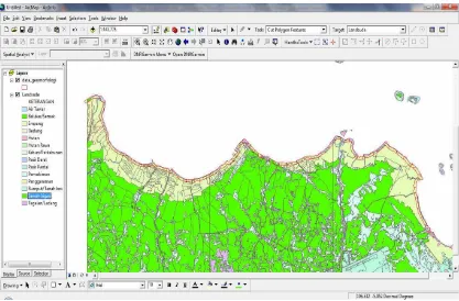
Geomorphological process is a natural process that took place on the earth surface so that there is a change of land forms on the surface of earth. Changes in the form of land formations caused differences in the earth's surface that will form various compositions and physical characteristics and visually different. These differences can be clearly identified through the characteristic of relief/morphology, structure/lithology, and processes, geomorphology. Based on morphology, the coastal areas can be grouped into 4 types, namely: (1) Steep rugged coast (cliff), (2) Coastal coral reefs, (3) Beach, (4) Coastal brackish swampy. Parameter data are then classified according to the class of indicators proposed by Gornitz (1991). Groups of land cover types are: (1) Aluvial, including Pond, Salting, Rice Irrigation, Rain fed Low, moor/ Field, (2) Briny Swamp, including: shrubs / bushes and swamps, (3) Mongrove forest, including Swamp Forest, (4) Beach building, including: building of Settlement, (5) Estuary and lagoon covers fresh water and coast land, (6) Beach Sand, includes sand beach and sand land. One example of geomorphological map is used for coastal vulnerability analysis is shown in Figure 5.
Figure 5. Geomorphology map for
coastal vulnerability analysis
(b) Sea Level Rise Map
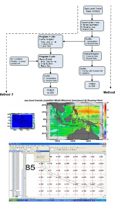
require the observation of sea surface height information for a relatively long, so sometimes difficult to obtain accurate information for a variety of vast coastal areas such as Indonesia. Determination in situ sea level rise is done by measuring the water level with the tide gauge, since the development of satellite technology then this process can be observed by using satellite altimetry. Observation of sea level with tide gauge and satellite altimetry can certainly complement each other information about SLR, where these data can be combined (merged) and the reanalysis process can be done.
Data trend of sea level changes can be obtained by satellite altimeters such as TOPEX/POSEIDON and JASON 1 and 2 which can be downloaded at the site:
http://www.aviso.oceanobs.com/en/news/ocean-indicators/mean-sea-level/index.html. The resulting data format NetCDF (Network Common Data Form) using a grid system size 0,25ox 0,25o or approximately 27,8 km x 27,8 km
and is available from October 1992 to July 2009 with worldwide coverage. Calculation of global sea level rise uncertainty analysis of each correction altimetry and comparison with tide gauge trends that give an error of about 0,6 mm/year at 90% confidence interval.
The objective of this laboratory work is that each participant is able to do the acquisition, processing and integrating data trend of relative sea level rise to the determination of Coastal Vulnerability Index (CVI).
(c) Tide Map
Tide parameters were used to determining of coastal vulnerability index, which information about vertical difference between high tide and low tide it is called the tidal range that contribute to coastal inundation hazard. Information about the tides can be obtained through measurements on the field or using the tidal prediction. Along with the improvement of science and technology, so information about the tide can be obtained via ernet in the form of real-time data or model result. Based on the periodic characteristic of sea surface level because of tides can be predicted/modeled more accurately in the long time range, so the highest range of tidal can be known.
More information about sea surface level can be accessed from http://uhslc.soest.hawaii.edu/ uhslc/data.html which produced by Joint Archive for Sea Level (JASL), the official of JASL now is Global Sea Level Observing System (GLOSS) data center. In Indonesia, National Coordinating Agency for Surveys and Mapping (BAKOSURTANAL) became contributor of this data. The other information about sea level can be accessed from http://www.ioc-sealevelmonitoring.org/list.php which is global monitoring station services for measurement of real time sea surface. These service are part of the IOC programme consisted of (i) the Global Sea Level Observing System Core Network, and (ii) the networks under the regional tsunami warning systems in the Indian Ocean (IOTWS), North East Atlantic & Mediterranean (NEAMTWS), Pacific (PTWS) and the Caribbean (CARIBE-EWS). In Indonesia the contributor of data is BAKOSURTANAL where there are 19 stations scattered in the Indonesian seas.
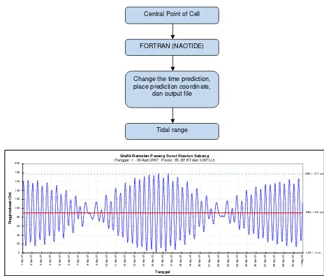
In this laboratory work, tidal information obtained through the prediction with the tide prediction model global NAOTIDE which is assimilation from TOPEX/POSEIDON data and global and regional model around of Japan. This model was developed by Matsumoto, K., T. Takanezawa, and M. Ooe and run with the FORTRAN software.
Grafik Ramalan Pasang Surut Stasiun Sabang
(Tanggal : 1 - 30 April 2007 Posisi : 95.30º BT dan 5.90º LU)
MSL = 90 cm
LW = 1 cm HW = 177 cm
0 20 40 60 80 100 120 140 160 180 200 1 -A p r-0 7 2 -A p r-0 7 3 -A p r-0 7 4 -A p r-0 7 5 -A p r-0 7 6 -A p r-0 7 7 -A p r-0 7 8 -A p r-0 7 9 -A p r-0 7 1 0 -A p r-0 7 1 1 -A p r-0 7 1 2 -A p r-0 7 1 3 -A p r-0 7 1 4 -A p r-0 7 1 5 -A p r-0 7 1 6 -A p r-0 7 1 7 -A p r-0 7 1 8 -A p r-0 7 1 9 -A p r-0 7 2 0 -A p r-0 7 2 1 -A p r-0 7 2 2 -A p r-0 7 2 3 -A p r-0 7 2 4 -A p r-0 7 2 5 -A p r-0 7 2 6 -A p r-0 7 2 7 -A p r-0 7 2 8 -A p r-0 7 2 9 -A p r-0 7 3 0 -A p r-0 7 1 -M a y -0 7 Tanggal T in g g i m u k a a ir (C m )
Figure 7. Flowchart tide prediction data and sample of visualization tidal prediction in Sabang Station.
Table 1. Sample output tidal prediction with NAOTIDE program
tidal height Geocentric
Elapsed
day Tide(cm) Short-p Long-p M D Yr H M MJD Longitude Latitude
0 21.802 24.51 -2.708 12/ 1 2008 0:00 0 54801 106.398 -6.0077
0.041667 32.262 34.959 -2.697 12/ 1 2008 1:00 0 54801.04 106.398 -6.0077
0.083333 39.455 42.141 -2.686 12/ 1 2008 2:00 0 54801.08 106.398 -6.0077
0.125 42.662 45.336 -2.674 12/ 1 2008 3:00 0 54801.13 106.398 -6.0077
0.166667 41.748 44.41 -2.662 12/ 1 2008 4:00 0 54801.17 106.398 -6.0077
0.208333 37.153 39.803 -2.649 12/ 1 2008 5:00 0 54801.21 106.398 -6.0077
0.25 29.753 32.39 -2.637 12/ 1 2008 6:00 0 54801.25 106.398 -6.0077
0.291667 20.651 23.275 -2.623 12/ 1 2008 7:00 0 54801.29 106.398 -6.0077
0.333333 10.943 13.552 -2.61 12/ 1 2008 8:00 0 54801.33 106.398 -6.0077
0.375 1.515 4.111 -2.595 12/ 1 2008 9:00 0 54801.38 106.398 -6.0077
0.416667 -7.071 -4.49 -2.581 12/ 1 2008 10:00 0 54801.42 106.398 -6.0077
0.458333 -14.597 -12.031 -2.566 12/ 1 2008 11:00 0 54801.46 106.398 -6.0077 Central Point of Cell
FORTRAN (NAOTIDE)
Change the time prediction, place prediction coordinate,
dan output file
(d) Significant wave height Processing
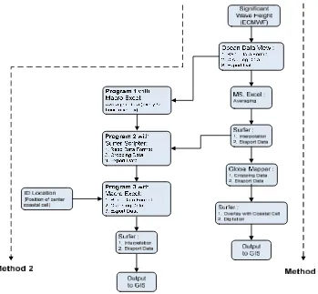
Significant wave height is wave height average (from peak to valley) from one-third highest sea wave. In coastal vulnerability, the significant wave height becomes a parameter related to the coastal inundation hazard. Utilization of this wave data is hardly done due to the lack of data on a national scale waves in Indonesia. There are rarely observed wave data in situ, so it requires data derived from satellite altimetry.
Significant wave height data derived from ECMWF (European Centre for Medium-Range Weather Forecasts) can be downloaded from http://ecmwf.int/. Processing method is a reanalysis of the data used, and the assimilation model (numerical weather prediction) satellite and in situ data. This organization provides a medium-long term forecasting for the data's atmosphere / weather, and super-computing facilities for scientific research and the scientific and technical cooperation with the satellite agency and the European Commission. ECMWF is also a result of the development of dynamic and synoptic meteorology more than 100 years and more than 50 years of development in numerical weather prediction (Numerical Weather Prediction). In 1998 the seasonal forecasting system started operation and in 2002 introduced a monthly forecasting system. The data processing step can be seen in Figure 8 and the example result of SWH data processing results shown in Figure 9.
.
Figure 9. Example Significant Wave Height Data Processing
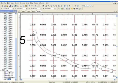
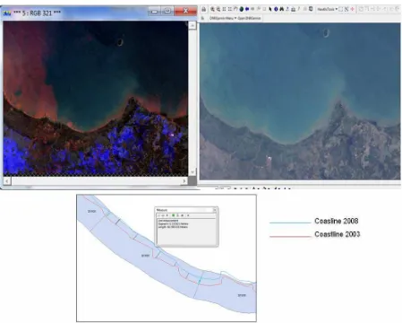
(e) Coastline Change Map
Changes in shoreline is one of the parameters used in the determination of Coastal Vulnerability Index. The beach is a zone that is dynamic because it is a zone of intersection and interaction between air, land and sea. The coastal zone continues to experience ongoing adjustment process leading to a natural balance to the impact of external and internal influences both natural and human intervention. Natural factors such as waves, currents, tides, wind action, climate, and tectonic and volcanic activity. While the activity of human intervention is the use of coastal areas such as industry, fisheries, ports, mining and settlement. Then the coastal shoreline change of the coastal region was declared vulnerable.
Figure 10. Coastline changes map derived from satellite images
(f) Coastal Elevation Map
There are many way to obtain Digital Elevation Model (DEM) data, Interferometric Synthetic Aperture Radar (SAR) is new algorithm to create a new DEM data. Image data from SAR images can be obtained from satellite or plane rides, such SRTM and ASTER data. In this training we used Global Digital Elevation Model (GDEM) derived from satellite Advanced Spaceborne Thermal Emission and Reflection Radiometer(ASTER). GDEM has the accuracy (spatial resolution) 30 meters, while the coverage area is nearly the entire surface of the earth. GDEM data can be downloaded on http://www.gdem.aster.ersdac.or.jp, which released the data format is TIF (Tag Image Format) which can be opened directly in GIS software, making it easier for further analysis.
Figure 11. Elevation map derived from SRTM data
(f) Data Integration and determining of Coastal Vulnerability Index
The value of coastal vulnerability index influenced by six parameter, that is geomorphology, relative sea level rise, mean tidal range, mean wave height, coastal slope, and shoreline change. These parameters have constant and dynamic value changed to time. The parameters which have changed value are geomorphology, relative sea level, and coastal slope. While the parameters that have a dynamic values are mean tidal range, mean wave height, and shoreline changed.
Before obtaining the value of coastal vulnerability index, the six parameter values must be classified into five classes, namely is very low, low, medium, high, and very high. These processes have four cases that will affect the range of classes from the six parameters. The cases are west coast, east coast, national and local, but here only local case will be discussed only in local cases. The criteria of coastal vulnerability index shown in Tabel 2. Value of coastal vulnerability index can be calculated by the formula (Thieler and Hammar-Klose, 2000):
Where
a= geomorphology parameter b= relative sea level rise parameter c= mean tidal range parameter d= mean wave height parameter e= slope parameter
Table 2. Coastal Vulnerability Index (Thieler and Hammar-Klose, 2000; USGS).
Very Low Low Medium High Very High
1 2 3 4 5
Geomorphology
-Rocky, cliffed coastal, fjords,
Medium cliffs, indented coasts
Low cliffs, glacial drift, alluvial plain
Cobble beaches, estuary, lagoon
Barrier beaches, sand beaches, salt marsh, mud flats, deltas, mangrove, coral reefs Coastal Slope % >1,9 1,3 – 1,9 0,9 – 1,3 0,6 - 0,9 <0,6
mm/ year
m/ >+2,0 +1,0 - +2,0 -1,1 - -2,0 <-2,0 year Accretion Accretion Erosion Erosion Mean tidal range m >6,0 4,1 – 6,0 2,0 – 4,0 1,0 – 1,9 <1,0 Significant wave height m <1,1 1,1 – 2,0 2,0 – 2,25 2,25 – 2,60 >2,60
>1,36
Shoreline erosion/accretion -1,0 - +1,0
Parameters Units
Ranking
Relative sea level rise <-1,21 -1,21 – 0,1 0,1 – 1,24 1,24 – 1,36
After we get the CVI values, then these values will be integrated into each cell spacially. Integration of this values will use ArcGis software. Examples of coastal vulnerability analysis on SLR impact using the GIS shown in Figure 12.
Fig 12. Map of Coastal Vulnerability in Baten Area, Java
3.2 Field Study in each local area of participant
After completion of training, all participants conducted field studies in each region. Participants analyzed the trend of SLR data from satellite altimeter and use the SLR data to assess the inundation along the coast due to SLR. They also conduct field checks by taking photos of beach conditions. Some examples of field study results of the workshop participants are presented in Figure 13. The full report of field study by participants are presented in proceedings.
Figure 11. Coastal condition and Indundation prediction 20 year later and SLR trends
SLR =3.8 mm/year
-40 -30 -20 -10 0 10 20 30 40
S
S
H
A
(c
m
3.3 Workshop
After training participants conduct field studies, they were invited back to attend the workshop. At the workshop discussed the results of the study in the field. In general, the participants have difficulties to obtain a local spatial data which used for coastal vulnerability analysis.
At the workshop invited speakers from several related institutions, such as the Ministry of Maritime Affairs and Fisheries, Bureau of Meteorology, Climatology and Geophysics, Indonesian Institute of Oceanography, National Coordinating Agency for Surveys and Mapping, National Development Planning Agency. Workshop activities conducted at Delamer Hotel during 3 days from 10 to 12 December 2010 (Figure 12).
Figure 14. Workshop activities at Delamer Hotel, Puncak Bogor, Indonesia
Here we give a short characterization of the contents of the presentations.
1. Dr. Subandono Diposaptono (Director of Coastal and Marine, Ministry of Marine Affairs and Fisheries, Indonesia)
Title : Impacts and Adaptation of Sea Level Rise In coastal and small islands This presentation explained the vulnerability and impacts SLR on coastal areas and small islands, the process of adaptation to climate change, Case Study of Central Java and in particular the Semarang City and Pekalongan Regency.
Inundation depth data integration and IKONOS satellite images of 2007 are presented in the figure below. The Figure 15 shows the shape and depth of inundation of land use which will be experienced in scenario SLR 100 years.
Figure 15. Spatial data on the depth of inundation SLR 100 years (0.775 m) future. Color difference above a portrait of inundation depth difference in meters in the coastal city of Semarang.
(2) Dr. Parluhutan Manurung (Director of Tidal and Gravity, National Coordinating Agency for Surveys and Mapping)
Title: Sea Level Rise Monitoring in Indonesia
This presentation explained the monitoring system sea level in Indonesia, tide data processing, tides prediction, analysis sea level trend in some location in Indonesia.
(3) Dr. Augy Syahailatua (Director of Ambon Station Indonesian Institute of Oceanography)
Title : Climate Change Impact on Marine Resources and Fisheries
This presentation explained the impact of SLR on marine ecosystem, costal fishery, fish distribution, spawning ground and fish sustainability.
(4) Dr. Nurhayati (Director of Marine Climate, Bureau of Meteorology, Climatology and Geophysics).
Title : Data availability for analysis of climate change and impact on marine and fisheries.
This presentation explained the responsibility of Indonesian local government to support spatial data.
(5) Raja Siregar (Resilience & Adaptation Team Leader of ICCTF Project, National Development Planning Agency).
Title: Climate Change: Indonesian Adaptation and Mitigation Activities Priority.
Sector such as (1) Marine, Coastal and Small Island Ecosystem Mitigation and Adaptation, (2) Integrated Vulnerability and Adaptation Assessment to Sea Level Rise of Coastal Areas, (3) The high spatial and accuracy of Digital elevation Model and land cover data development for the rapid sea level rise assessment on the coastal region, (4) The Role and Dynamics of Coastal Ecosystem in Oceanic CO2 Cycles, (5) The Influence of Climate Change on Coastal Protection Planning and Policies in Indonesia, (6) Marine, Coastal and Small Island Ecosystem Mitigation and Adaptation, (7) Indonesian Coral Triangle Initiatives Program, (8) Integrated Vulnerability and Adaptation Assessment to Sea Level Rise of Coastal Areas.
4. Conclusions
After finishing the activity of training, field studies and workshops, we have enhanced the ability of trainees to assess the vulnerability of coastal areas of the SLR. We also evaluate that this activity has been growing the concern of scientists and policy makers on the negative impacts SLR. Through this workshop, the policy makers and training participants are expected to plan mitigation and adaptation activities to anticipate SLR.
5. Future Directions
These training activities are planned to be held every year given the vast beaches in Indonesia and the still limited ability and number of Indonesian scientists and institutions in assessing coastal vulnerability to SLR.
Data from satellite sea level is very important for Indonesia because tide gauge equipment is still limited in number. Therefore, research to improve the accuracy of the measurement of sea level becomes very important to do in the future.
Generally coastal areas in Indonesia experienced a negative impact on the SLR, the mitigation and adaptation activities must be done for example by replanting mangroves in the damaged region.
References
BAPPENAS. 2010. Indonesian Climate Change Sectoral (ICCSR) Road Map. National Development Planning Agency ICCSR (www.bappenas.go.id)
Gornitz, V.M., Daniels, R.C., White, T.W., and Birdwell, K.R., 1994, The development of a coastal vulnerability assessment database, vulnerability to sea-level rise in the U.S. southeast: Journal of Coastal Research, Special Issue No. 12, p. 327-338.
Manurung, P. 2004. Permanen Sea Level Monitoring in Indonesia. GLOSS Training . February, 2004 Malaysia.
Saidy, A.R., and Y. Aziz. 2009. Sea level Rise in South Kalimantan, Indonesia – An Economic Analysis of Adaptation Strategies in Agriculture . Research Report. Faculty of Agriculture, Lambung Mangkurat University, Banjar Baru. Indonesia Co-published by the International Development Research Center.
Appendices:
Appendix 1. Training and Workshop (Agenda)
INCREASING CAPACITY OF LOCAL SCIENTISTS FOR CLIMATE CHANGE
IMPACT & VULNERABILITY ASSESSMENT ON INDONESIA ARCHIPELAGOS:
TRAINING IN IN-SITU/SATELLITE SEA LEVEL MEASUREMENT
IPB International Convention Centre (IICC), Bogor (17-24 May 2010)
17 May : Opening Ceremony 08.00 – 08.30
08.30 – 09.00
09.00 – 10.00 10.00 – 10.30 10.30 – 12.00 12.00 – 13.00 13.00 – 15.00 15.00 – 15.15 15.15 – 17.00
Registration
Opening Ceremony (Speech : Training Coordinator, Head of Marine Science and Technology Department)
Global Warming (Dr. Alan Koropitan, ITK-IPB) Coffee Breaks
Tidal (Dr. Parluhutan Manurung) Break (Lunch, etc)
Sea Level Rise (Dr. Parluhutan Manurung) Coffee Breaks
Vulnerability Assessment to SLR (Dr. Ivonne Rajawane)
18 May : Lecture and Laboratory Work 08.00 – 09.00
09.00 – 10.00 10.00 – 10.15 10.15 – 12.00
12.00 – 13.00 13.00 – 14.00
14.00 – 15.00 15.00 – 15.15 15.15 – 17.00
Wave (Dr. I Wayan Nurjaya, ITK, IPB)
Coastal Geomorphology/Landuse (Dr. Bisman Nababan) Coffee Breaks
Laboratory Work : GIS for assessment of coastal vulnerability (Samsul Bahri)
Break (Lunch, etc)
Laboratory Work : GIS for assessment of coastal vulnerability (Anggi Afif)
Coastal Line (Erosion/Accretion) (Prof. Dr. Mulia Purba) Coffee Breaks
Laboratory Work : Introduction to Remote Sensing (Risti Endrian)
19 May : Laboratory Work 08.00 – 10.00
10.00 – 10.15 10.15 – 12.00 12.00 – 13.00 13.00 – 15.00 15.00 – 15.15 15.15 – 17.00
Laboratory Work : Geomorphology data processing (Sakka) Coffee Breaks
Laboratory Work : Sea level trend data processing (M. Tri Hartanto) Break (Lunch, etc)
Laboratory Work : Tidal data processing (Asyari Adisaputra) Coffee Breaks
Laboratory Work : Significant wave height data processing (Erwin Maulana)
20 May : Laboratory Work 08.00 – 10.00
10.00 – 10.15 10.15 – 12.00
Laboratory Work : Elevation and slope data prosessing (Santoso) Coffee Breaks
12.00 – 13.00 13.00 – 15.00 15.00 – 15.15 15.15 – 16.00 16.00 – 17.00
Break (Lunch, etc)
Laboratory Work : Determining the Coastal Vulnerability Index (Tim) Coffee Breaks
Laboratory Work : Case study (Andri Purwandani) Matlab Introduction (Dr. Henry Munandar)
21 May – Introduction to Satellite Altimetry (Lecture & Lab Work) 08.00 – 08.45
09.00 – 12.00 12.00 – 13.00 13.00 – 14.00 14.00 – 17.00
Lecture – Survey of Satellite Altimetry (Dr. Robert Leben) Laboratory Work
Break (Lunch, etc)
Afternoon Lecture – Datasets and Data Access Laboratory Work
22 May – Ocean Circulation – Mesoscale and Large Scale (Lecture & Lab Work) 08.00 – 08.45
09.00 – 10.00 10.00 – 12.00 12.00 – 13.00 13.00 – 14.00 14.00 – 17.00
An operational use of remote sensing and marine-GIS for assessing the climate change impact on fisheries and aquaculture (Prof. Seichi Saitoh)
Lecture – Mesoscale/Geostrophic (Dr. Robert Leben) Laboratory Work
Break (Lunch, etc)
Lecture – Large Scale/Climate (Dr. Robert Leben) Laboratory Work
23 May – Field Study
12.00 – 15.00 Tanjung Priok Port, Jakarta: (In situ Sea Level Measurement)
24 May – Indonesian Sea Level (Lecture & Laboratory Work) 08.00 – 08.45
09.00 – 12.00 12.00 – 13.00 13.00 – 14.00 14.00 – 17.00 17.00 – 17.15
Lecture (Dr. Robert Leben)
Laboratory Work (Dr. Robert Leben) Break (Lunch, etc)
Lecture (Dr. Robert Leben)
Appendix 2.
Increasing Capacity of Local Scientists for Climate Change Impact &
Vulnerability Assessment on Indonesia Archipelagos:
Workshop In In-Situ/Satellite Sea Level Measurement
Delamer Hotel, Puncak Bogor, 10-11 November, 2010
10 November 2010: 18.00-19.00 Registration 19.00-19.30 Opening
19.30-10.45 General Discussion 19.45-21.00 Dinner
11 November 2010:
08.30-10.00 Review of participant experience in field station 10.00-10.30 Coffie Break
10.30-12.00 Problem Solving (Inundation and vulnerability coast analysis) 12.00-13.30 Break: Lunch etc.
13.00-15.00 Presentation of Participants 15.00-15.30 Coffie break
15.30-17.00 Presentation of Participants
12 November 2010 (Invited Speaker Presentation)
08.00-08.30 ; Sea Level Monitoring in Indonesia (Dr. Parluhutan Manurung, Director of Tidal and Gravity, National Coordinating Agency for Surveys and Mapping).
08.30-09.00 : Climate Change Impact on Marine Resources and Fisheries (Dr. Augy Syahailatua (Director of Ambon Station Indonesian Institute of Oceanography).
09.00-09.30: Data availability for analysis of climate change and their impact on marine and fisheries. (Dr. Nurhayati (Director of Marine Climate, Bureau of Meteorology, Climatology and Geophysics).
09.30-10.00 : Impacts and Adaptation of Sea Level Rise In coastal and small islands. (Dr. Subandono Diposaptono (Director of Coastal and Marine, Ministry of Marine Affairs and Fisheries, Indonesia).
10.30-11.00: Climate Change: Indonesian Adaptation and Mitigation Activities Priority. Raja Siregar (Resilience & Adaptation Team Leader of ICCTF Project, National Development Planning Agency).
Appendix 3. List of Participants Speakers/Lecture:
No. Name InstitutionAddress
1. Dr. Alan Koropitan
Department of Marine Science & Technology, Bogor Agricultural University.
Marine Center Campus, FPIK-IPB Darmaga, Bogor 16680, Indonesia. Tel/Fax: +62-251-8623644
Email: [email protected]
2. Dr. Parluhutan Manurung
National Coordinating Agency for Surveys and Mapping.
Jl. Raya Jakarta-Bogor KM 46m Cibinong, Indonesia. Tel/Fax: +62-21-8753155/+62=21-87908988/87916647 Email: [email protected]
3. Dr. Ivonne Rajawane
Study Program of Oceanography, Bandung Institute of Technology.
Jl. Ganesa, Bandung
Tel/Fax: +62-22-2505253 etx:3182 E-mail: [email protected]
4. Dr. I Wayan Nurjaya
Department of Marine Science & Technology, Bogor Agricultural University.
Marine Center Campus, FPIK-IPB Darmaga, Bogor 16680, Indonesia. Tel/Fax: +62-251-8623644
Email: [email protected]
5. Dr. Bisman Nababan
Department of Marine Science & Technology, Bogor Agricultural University.
Marine Center Campus, FPIK-IPB Darmaga, Bogor 16680, Indonesia. Tel/Fax: +62-251-8623644
Email: [email protected]
6. Prof. Dr. Mulia Purba
Department of Marine Science & Technology, Bogor Agricultural University.
Marine Center Campus, FPIK-IPB Darmaga, Bogor 16680, Indonesia. Tel/Fax: +62-251-8623644
Email: [email protected]
7. Dr. Henry Munandar Manik
Department of Marine Science & Technology, Bogor Agricultural University.
Marine Center Campus, FPIK-IPB Darmaga, Bogor 16680, Indonesia. Tel/Fax: +62-251-8623644
Email: [email protected]
8. Dr. Robert Leben
Colorado Center for Astrodynamics Research Center, Colorado University, Boulder. USA. ECNT 320, 431 UCB, University of Colorado Boulder, CO 80309-0431
PHONE: (303) 492-3105 FAX: (303) 492-2825 Email: [email protected]
9. Prof. Seichi Saitoh
Center for Sustainability of Science, Hokkaido University.
3-1-1 Minato-cho, Hakodate 041-8611. Tel/Fax: Tel. +81-138-40-5501
Marine Center Campus, FPIK-IPB Darmaga, Bogor 16680, Indonesia. Tel/Fax: +62-251-8623644
Email: [email protected]
11 Dr. Augy Syahailatua
Institute of Oceanology UPT- LIPI Ambon Tel/Fax: +628128832515
E-mail: [email protected]
12 Dr. Nurhayati
Marine Climate, Bureau of Meteorology, Climatology and Geophysics (BMKG)
Jl. Angkasa I, No.2 Kemayoran, Jakarta Pusat 10720 Telp/Fax: +62 21 4246321/ +62 21 4246703.
E-mail : [email protected]
13 Dr. Subandono Diposaptono
Directorate of Marine and Coastal. Ministry of Marine Affairs and Fisheries,
Jl. Merdeka Selatan, Jakarta, Indonesia Tel/Fax:
e-mail:[email protected]
14 Raja Siregar
Indonesia Climate Change Trust Fund (ICCTF) Wisma Bakrie 2, 6th Floor
Jl. H.R. Rasuna Said Kav. B-2 Jakarta 12920 - Indonesia Phone: +62 (21) 57945760 Fax: +62 (21) 57945759
E-mail: [email protected]
Instructors:
No. Name Insitution/Address
1. Samsul Bahri
Department of Marine Science & Technology, Bogor Agricultural University.
Marine Center Campus, FPIK-IPB Darmaga, Bogor 16680, Indonesia. Tel/Fax: +62-251-8623644
2. Risti Endriani Arhatin
Department of Marine Science & Technology, Bogor Agricultural University.
Marine Center Campus, FPIK-IPB Darmaga, Bogor 16680, Indonesia. Tel/Fax: +62-251-8623644
University: [email protected]
3. Anggi Afif
Department of Marine Science & Technology, Bogor Agricultural University.
Marine Center Campus, FPIK-IPB Darmaga, Bogor 16680, Indonesia. Tel/Fax: +62-251-8623644
4. Sakka
Hasanuddin University Makassar Indonesia. [email protected]
5. M. Tri Hartanto
Department of Marine Science & Technology, Bogor Agricultural University.
Marine Center Campus, FPIK-IPB Darmaga, Bogor 16680, Indonesia. Tel/Fax: +62-251-8623644
6. Asyari Adisaputra
Department of Marine Science & Technology, Bogor Agricultural University.
Marine Center Campus, FPIK-IPB Darmaga, Bogor 16680, Indonesia. Tel/Fax: +62-251-8623644
7. Erwin Maulana
Department of Marine Science & Technology, Bogor Agricultural University.
Marine Center Campus, FPIK-IPB Darmaga, Bogor 16680, Indonesia. Tel/Fax: +62-251-8623644
8. Santoso
Department of Marine Science & Technology, Bogor Agricultural University.
Marine Center Campus, FPIK-IPB Darmaga, Bogor 16680, Indonesia. Tel/Fax: +62-251-8623644
9. Heron Surbakti
Sriwijaya Unversity Kampus UNSRI Palembang
10. Andri Purwandani
Agency for Assessment and application of technology
Jl. Thamri Jakarta, Indonesia
Participants:
No Name Institution/Address
1. Achmad Fachruddin Sayh
Tronojoyo University
Jl. Raya Telang PO.BOX 2 Kamal Bangkalan Madura, Indonesia
Telp. 031 3011146
2. Andi Rahman
Ministry of Marine Affair and Fisheries Biro Perencanaan
Jl. Medan Merdeka No. 16 Lt. 7 Gedung Mina Bahari I
Jakarta, Indonsia
3. Aris Ismanto
Diponegoro University Jl. Prof. H. Soedarto SH
Rembalang Semarang - 50265
[email protected] [email protected]
4. Edison Harteman
University of Palangkaraya
Jl. Yos Sudarso Tanjung Nyaho Palangkaraya 73112 Telp. +6281310251559
5. Eka Rosdiman
Dasmasela Jl. Gunung Salju Amban Manokwari, Papua Barat [email protected]
7. Abdul Naafi
Regional Planning and Development BAPPEDA Kab. Sukabumi
Komp. Perkantoran Pemda Jajaway Pelabuhanratu Sukabumi
No. Telp (0266) 434085 [email protected]
8. Mubarak
University of Riau
Kampus Binawidya Km. 12,5 Kelurahan Simpang Baru Panam - Pekanbaru – Riau
9. Justhinus Choendrat Peday
Ministry of Marine Affair and Fisheries KKP Prop. Papua Barat
Jl. Merdeka 7B, Manokwari Telp 0986213182
10. M. Alinurdin
Ministry of Marine Affair and Fisheries KKP Prop. Kalimantan Barat
Jl. Sutan Syahrir No. 16 Pontianak Telp. 0561 766073
11. Adnan
Mulawarman University
Jl. Gunung Tabur No.1 Kampus UNMUL Gn. Kelua Samarinda
12. Kemal Taj
Ministry of Marine Affair and Fisheries DKP Prop. Bangka Belitung
Komp. Perkantoran Kep. Babel Jl. Pulau Bangka, Kel. Air Itam [email protected]
13. Halili
Fakultas Perikanan dan Ilmu Kelautan Universitas Haluoleo.
Tlp/Fax. 0401- 3193782 [email protected]
14. Yempita Efendi
Faculty of Fisheries Univ. of Bung Hatta
Jl. Sumatera Ulak Karang Padang [email protected]
15. Junus Matakena
Regional Planning and Development BAPPEDA Prop. Maluku
Jl. Raya Pattimura No 1 Ambon Telp. 0911 3522043
16. Muhammad Banda Selamat
Hasanuddin University
Jl. P. Kemerdekaan Km 10, Makassar [email protected]
17. Teja Arief
Jl. Baru Perancak, Br. Dangin Berawa, Desa Perancak, Negara, Jembrana, Bali 82251 Telp. 0365-44266/67; Fax. 0365-44278 [email protected]
Siwi Perancak, Negara, Jembrana, Bali 82251 Telp. 0365-44266/67
Fax. 0365-44278
19. Zainul Hidayah
Tronojoyo University
Jl. Raya Telang PO.BOX 2 Kamal Bangkalan Madura, Indonesia
Telp. 031 3011146
20. Ferdy Pattikaihatu
Pattimura Unversity
Jl. Ir. M. Putuhena-Ambon
Telp. 0911-322626; Fax. 0911-322627 [email protected]
21. Aninda Wisaksanti Rudiastuti
Department of Marine Science & Technology, Bogor Agricultural University.
Marine Center Campus, FPIK-IPB Darmaga, Bogor 16680, Indonesia. Tel/Fax: +62-251-8623644
22. Riza Aitiando Pasaribu
Department of Marine Science & Technology, Bogor Agricultural University.
Marine Center Campus, FPIK-IPB Darmaga, Bogor 16680, Indonesia. Tel/Fax: +62-251-8623644
23. Fina Mariany
Department of Marine Science & Technology, Bogor Agricultural University.
Marine Center Campus, FPIK-IPB Darmaga, Bogor 16680, Indonesia. Tel/Fax: +62-251-8623644
24. Indra Verdian Karif
Department of Marine Science & Technology, Bogor Agricultural University.
Marine Center Campus, FPIK-IPB Darmaga, Bogor 16680, Indonesia. Tel/Fax: +62-251-8623644
25. Daniel Siahaan
Department of Marine Science & Technology, Bogor Agricultural University.
Marine Center Campus, FPIK-IPB Darmaga, Bogor 16680, Indonesia. Tel/Fax: +62-251-8623644
26. Mochammad Agung Setya Aji
Department of Marine Science & Technology, Bogor Agricultural University.
Marine Center Campus, FPIK-IPB Darmaga, Bogor 16680, Indonesia. Tel/Fax: +62-251-8623644
27 Rianto
University of Riau
Kampus Binawidya Km. 12,5 Kelurahan Simpang Baru Panam - Pekanbaru – Riau
28 Aulia
University of Riau
Kampus Binawidya Km. 12,5 Kelurahan Simpang Baru Panam - Pekanbaru – Riau
29 Vito Yuwono
Ministry of Marine Affair and Fisheries DKP propinsi Kalimantan Timur
Jln. A.Yani. KM. 36, Banjarbaru Telepon/Fax : (0511) 477 2124
31 Zulham A.H
Department of Marine Science & Technology, Bogor Agricultural University.
Marine Center Campus, FPIK-IPB Darmaga, Bogor 16680, Indonesia. Tel/Fax: +62-251-8623644
32 Dwi Fajriyati Inaku
Department of Marine Science & Technology, Bogor Agricultural University.
Marine Center Campus, FPIK-IPB Darmaga, Bogor 16680, Indonesia. Tel/Fax: +62-251-8623644
33 Jefry Bemba
Khairun University Jl. Gambesi Mania Ternate
34 Kaharuddin
Department of Marine Science & Technology, Bogor Agricultural University.
Marine Center Campus, FPIK-IPB Darmaga, Bogor 16680, Indonesia. Tel/Fax: +62-251-8623644
35 Wahyu A Hidayat
Department of Marine Science & Technology, Bogor Agricultural University.
Marine Center Campus, FPIK-IPB Darmaga, Bogor 16680, Indonesia. Tel/Fax: +62-251-8623644
36 Mardiansyah
UIN Syarif Hidayatullah University Jl. Ir. H. Juanda No. 95
Ciputat 15412, Jakarta Telepon: +62217493606 Fax: +62217493315
37 Sri Pujiyati
Department of Marine Science & Technology, Bogor Agricultural University.
Marine Center Campus, FPIK-IPB Darmaga, Bogor 16680, Indonesia. Tel/Fax: +62-251-8623644
38 Nyoman M. N. Natih
Department of Marine Science & Technology, Bogor Agricultural University.
Marine Center Campus, FPIK-IPB Darmaga, Bogor 16680, Indonesia. Tel/Fax: +62-251-8623644
39 Ilham
Ministry of Marine Affair and Fisheries Jl. Medan Merdeka No. 16
Jakarta, Indonesia
40 Rini Eksawati
Bureau of Meteorology, Climatology and Geophysics (BMKG)
Jl. Angkasa I, No.2 Kemayoran, Jakarta Pusat 10720 Telp/Fax: +62 21 4246321/ +62 21 4246703.
41 Rasidi
Ministry of Marine Affair and Fisheries
Jl. Medan Merdeka No. 16
Jakarta, Indonsia
42 Erlania
Ministry of Marine Affair and Fisheries
Jl. Medan Merdeka No. 16
Jakarta, Indonsia
43 Carlos Lisbon Sirait
Ministry of Marine Affair and Fisheries
Jl. Medan Merdeka No. 16
Jakarta, Indonsia
Jl. Medan Merdeka No. 16 Jakarta, Indonsia
45 Enda
Marine Center Campus, FPIK-IPB Darmaga, Bogor 16680, Indonesia. Tel/Fax: +62-251-8623644
46 Hanum Khrisna Fauzia
Department of Marine Science & Technology, Bogor Agricultural University.
Marine Center Campus, FPIK-IPB Darmaga, Bogor 16680, Indonesia. Tel/Fax: +62-251-8623644
47 Coryelisabety Dianovita
Department of Marine Science & Technology, Bogor Agricultural University.
Marine Center Campus, FPIK-IPB Darmaga, Bogor 16680, Indonesia. Tel/Fax: +62-251-8623644
48 Windra Jumadi
Department of Marine Science & Technology, Bogor Agricultural University.
Marine Center Campus, FPIK-IPB Darmaga, Bogor 16680, Indonesia. Tel/Fax: +62-251-8623644
49 Kaharuddin
Department of Marine Science & Technology, Bogor Agricultural University.
Marine Center Campus, FPIK-IPB Darmaga, Bogor 16680, Indonesia. Tel/Fax: +62-251-8623644
50 Wahyu A Hidayat
Department of Marine Science & Technology, Bogor Agricultural University.
Marine Center Campus, FPIK-IPB Darmaga, Bogor 16680, Indonesia. Tel/Fax: +62-251-8623644
51 Nuryani Widagti
Jl. Baru Perancak, Br. Dangin Berawa, Desa Perancak, Negara, Jembrana, Bali 82251 Telp. 0365-44266/67; Fax. 0365-44278
52 Ilham
Ministry of Marine Affair and Fisheries
Jl. Medan Merdeka No. 16
Jakarta, Indonesia
53 Rasidi
Ministry of Marine Affair and Fisheries
Jl. Medan Merdeka No. 16
Jakarta, Indonesia
54 Erlania
Ministry of Marine Affair and Fisheries Jl. Medan Merdeka
Jakarta, Indonesia
Funding sources outside the APN
1. Local government institution for transportation of participants: $ 6,000 2. “Beasiswa Unggulan” Ministry of National Education US $ 600
List of Young Scientists
(1) Ms. Aninda Wisaksanti Rudiastuti (Graduate Student) Department of Marine Science & Technology,
Bogor Agricultural University.
Marine Center Campus, FPIK-IPB Darmaga, Bogor 16680, Indonesia. Tel/Fax: +62-251-8623644
E-mail: [email protected]
Aninda is currently in the research stage to complete the master's thesis on the topic of GIS for coastal marine fisheries management. In this project he was involved actively to conduct field studies, collecting field data and instructors to assist the training participants.
Short message from young scientist:
By actively involved in this project I have gained additional knowledge from competent experts in their field, such as from experts from Colorado University and Hokkaido University. Besides, I became more skilled because it actively contributed to participant training in data processing using GIS software. This project is very helpful to finish my thesis because it also could be more to obtain field data.
(2) Dr. Mubarak (Lecturer and Researcher) Department of Fisheries
Riau University
Kampus Binawidya Km. 12.5 Pekanbaru – Riau
Indonesia
E-mail: [email protected]
Short message:
After obtaining knowledge through this training, we can explain to the various parties in scientific forums on the impact of climate change on coastal regions and small islands. The benefits of training also accelerated the development of science, particularly in the field of maritime.
Because so much benefited from the training, it is still necessary for the subsequent exercises continued and necessary to establish a forum that can continue to coordinate the study conducted.
I am as a participant, expressed my gratitude to all parties (speakers, instructors, and APN), particularly Mr. Jonson who has given us the opportunity to participate as a participant in the training event.
(3) Mr. Eka Rosdiman (Planning and Regional Development Staf) Planning and Regional Development Agency
Subang-West Java
Jl. Dewi Sartika No. 2 Subang, Indonesia E-mail: [email protected]
Short messange:
Glossary of Terms
APN Asia Pacific Network for Global Research
ASTER Advanced Spaceborne Thermal Emission and Reflection Radiometer CVI Coastal Vulnerability Index
DEM Digital Elevation Model
GIS Geographical Information System GDM Global Digital Elevation Model
ICCTF Indonesian Climate Change Sectoral
SLR Sea Level Rise
SRTM Shuttle Radar Topography Mission TOPEX Topography Experiment