Editor: John D. Harris and Paul L. Brown ©2009 Nova Science Publishers, Inc.
GIS-BASED HABITAT MODEL OF JAVAN
HAWK-EAGLE (
S
PIZAETUS
B
ARTELSI)
USING INDUCTIVE APPROACH IN JAVA ISLAND,
INDONESIA
Syartinilia
*a, Satoshi Tsuyuki
†b, and Jung soo Lee
‡ca
Landscape Architecture Department, Faculty of Agriculture, Bogor Agricultural University (IPB).
Jl. Meranti, Kampus IPB, Darmaga - Bogor 16680, Indonesia. b
Graduate School of Agricultural and Life Sciences, The University of Tokyo,
1-1-1 Yayoi, Bunkyo-ku, Tokyo 113-8657, Japan. c
Division of forest management and landscape architecture, College of forest and environmental sciences, Kangwon National University, chunchon.kanwon-do200-701, Korea.
A
BSTRACTThe Javan Hawk-Eagle (JHE) is categorized in the IUCN Red List of Threatened
Species (CITES Appendix 2) as one of the world’s rarest and most endangered raptors in
the remaining original natural forests of Java, Indonesia. Since it is not feasible to conduct complete field surveys for a landscape-scale, this paper proposes a GIS-based extrapolation model based on local-scale model in order to generate a map of potential and present habitat suitability for JHE in the entire landscape. Using autologistic regression, we developed a GIS-based habitat model for JHE in Java Island and subsequently estimated the population number of JHE. The obtained model will be the most useful for the wildlife management conservation planning process in order to help
identify “hot spots” that are most likely to harbor JHE. Most of the predicted suitable habitats in Java Island are distributed in the mountainous area. The area with the largest proportion of suitable habitat for JHE is located in East Java, and then followed by West Java and the last in Central Java. Totally, about 41 locations (85%) of 48 historical localities recorded were recognized as suitable habitat. The estimated number of JHE pairs based on model extrapolation would place the population size about 108-542 (median = 325) pairs. Although this estimated population is higher compared to other
*
E-mail: [email protected] ; [email protected] †
E-mail: [email protected] ‡
studies, JHE had always been described as either rare or very rare. The apparent discrepancy between this estimated population and others, which might not suggest an increase in present JHE, may be explained by several reasons such as increased accessibility to formerly unexplored habitat and more recent satellite imageries and GIS techniques application used in estimation of suitable habitat of JHE and finally will allow a better population estimate.
1.
I
NTRODUCTIONThe Javan Hawk-Eagle (Spizaetus bartelsi) is an endemic raptor and evergreen-forest specialist in the remaining original natural forests of Java, Indonesia [1]. The Javan Hawk-Eagle (JHE) is categorized in the IUCN Red List of Threatened Species (CITES Appendix 2) as one of the world’s rarest and most endangered raptors. Small population size, severe
habitat loss, forest fragmentation, and illegal hunting have all contributed to the “endangered”
status of this species [2, 3]. However, population estimates until very recently have been very low, based on the amount of suitable habitat remaining divided into the estimated size of individual territories. Various authors have estimated the population size differently; “Not more than 60 breeding pairs” [4] , “67–81 pairs” [5], “81–108 pairs” [6], “270–600 (median =
435) pairs” [7].
Predictive modeling commonly uses deductive and inductive approaches. Deductive models are based on theories about the behavior of the prehistoric population. Inductive models, which are more commonly used, are based on observed patterns in ground surveys or other data. One of the more powerful and widely used inductive techniques coupled with Geographic Information Systems (GIS) in habitat modeling is logistic regression [8, 9, 10]. Preliminary predictive habitat models were developed for a restricted portion of the JHE distribution in Gunung Gede-Pangrango National Park (TNGP) and its surrounding areas using logistic and autologistic regression model and successfully validated in the Southern part of West Java [11].This method provided a useful quantitative “firststep” for modeling endangered species distributions where specific habitat requirements are difficult to obtain.
Large-scale conservation planning requires the identification of priority areas in which species have a high likelihood of long-term persistence. This typically requires high spatial resolution data on species and their habitat. Such data are rarely available at a large geographical scale, so habitat distribution modelling is often required to identify the locations of suitable habitat. GIS can be used to construct spatially explicit habitat models for both common and rare wildlife species especially for a large geographical scale based on inductive approach [12, 13].GIS technology provides the ability to construct models of habitat that rely on existing or readily obtained information (e.g., remotely sensed images, digital elevation models, topographic maps, etc.). With adequate data collection, such models often can analytically identify specific habitat characteristics across wider landscapes with high predictive power and therefore provide considerable utility. Such models offer the possibility of being able to minimize field work, and GIS-based models are easily updated as new information becomes available.
identification of probability model of JHE habitat distribution efficiently over large areas. In addition, the method must be able to produce spatially explicit habitat suitability maps at the landscape level, which will be an important tool for the habitat management of this species. Since it is not feasible to conduct complete field surveys for a landscape-scale, GIS-based extrapolation models using an inductive approach can be used to generate maps of potential and present habitat suitability for JHE in the entire landscape.
Therefore, our primary objective was to extrapolate the predicted probability model of JHE habitat distribution from the local-scale model to landscape-scale model in order to generate maps of potential and present habitat suitability for JHE in the entire landscape. Subsequently, population number of JHE will be estimated.
2.
M
ETHOD OFA
NALYSISIn order to generate the present habitat suitability of JHE in Java Island, we extrapolated the best model that was developed in nest-site scale (Gunung Gede-Pangrango National Park (TNGP)and validated in regional-scale (southern parts of West Java) [11].Subsequently, the result was compared with the historical localities record of JHE for model accuracy. Afterward, predicted suitable habitat was used for calculating the population estimation of JHE in whole Java Island.
2.1 Study Area
Figure 1. Study area: Java Island (Source: GeoCover Landsat mosaic, S-48-05_2000, S-50-05_2000).
2.2 Model Extrapolation
GIS-based landscape model was developed to evaluate habitat suitability of JHE in Java Island because it was not possible to conduct nest-site scale field surveys for the entire Java Island. This landscape-scale model was developed based on extrapolation of the best model obtained from the previous study [11] that was an autologistic regression model which calculated 1,500m of neighborhood size (ALR_50). This model accounted spatial autocorrelation through the addition of autocovariate variable. The best model retained the explanatory environmental variables, i.e. slope (SLP), elevation (ELV), normalized different vegetation index (NDVI) and autocovariate (AUTOCOV).
Probability of the JHE habitat (Pi) is explained by the equation below.
0.2371 0.0070 0.0189 19.8063 6.8592
exp 1
1
AUTOCOV NDVI
ELV SLP
i P
SLP and ELV data were derived from Shuttle Radar Topography Mission (SRTM) Digital terrain elevation data of 2000. While, NDVI data obtained from MODIS NDVI 250m of 2002. For model extrapolation, 250*250 m pixel size was used.
2.3 Population Estimation
The number of breeding pairs of this species has been estimated by dividing the area of presumed suitable habitat by assumed home-range size. Suitable habitat was obtained from thresholding the predicted probability of JHE habitat at probability value of 0.5. In order to avoid the overestimate of the population size, we excluded the habitat patches with area below the 50 km2. In this study, the population size was estimated using minimum and maximum home range size. Minimum home range size was based on result of the best model of habitat distribution in TNGP and its surrounding areas [11] which assumed to have a high quality habitat and also agreed with the current approximate distance between nests in TNGP [19] and the median home range size in Java [7]. Even though the exact minimum home range size obtained was 225 ha, but we used 400 ha for population estimation. Home range size of 2,000 ha was selected as maximum home range size in this study, since several researchers had been used it for estimating population number of JHE [17, 18, 20, 21].
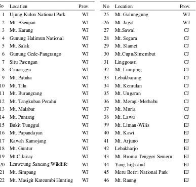
Table 1. Historical localities of JHE record in Java Island after 1980
No Location Prov. No Location Prov.
1 Ujung Kulon National Park WJ 25 Mt. Galunggung WJ
2 Mt. Aseupan WJ 26 Mt. Jagat WJ
3 Mt. Karang WJ 27 Mt.Sawal CJ
4 Gunung Halimun National WJ 28 Mt. Segara CJ
5 Mt. Salak WJ 29 Mt. Slamet CJ
6 Gunung Gede-Pangrango WJ 30 Mt.Cupu/Simembut CJ
7 Situ Patengan WJ 31 Linggoasri CJ
8 Cimanggu WJ 32 Mt. Lumping CJ
9 Mt. Patuha WJ 33 Lebakbarang CJ
10 Mt. Tilu WJ 34 Mt. Kemulan CJ
11 Mt. Burangrang WJ 35 Mt. Ungaran CJ
12 Mt. Tangkuban Perahu WJ 36 Mt. Merapi-Merbabu CJ
13 Mt. Malabar WJ 37 Mt. Muria CJ
14 Mt. Puntang WJ 38 Mt. Lawu CJ
15 Bukit Tunggul WJ 39 Mt. Liman-Wilis EJ
16 Mt. Papandayan WJ 40 Mt. Kawi EJ
17 Kawah Kamojang WJ 41 Mt. Arjuno EJ
18 Mt. Guntur WJ 42 Lebakharjo EJ
19 Mt.Cikuray WJ 43 Mt. Bromo Tengger Semeru EJ
20 Leuweung Sancang Wildlife WJ 44 Yang highland EJ
21 Mt. Simpang WJ 45 Meru Betiri National Park EJ
Table 1. (continued)
23 Mt. Tampomas WJ 47 Mt. Ijen EJ
24 Mt. Talaga Bodas WJ 48 Alas Purwo National Park EJ
Note: Prov, Province; WJ, West Java; CJ, Central Java; EJ, East Java.
Source: BirdLife International (2001); Setiadi et al., 2000; van Balen et al., 1999; 2001.
3.
RESULT
3.1 Model Extrapolation of JHE Habitat Distribution
JHE habitat distribution in entire Java Island based on ALR_50 model (Figure 2) was obtained from extrapolation of predicted probability model in TNGP and its surrounding areas which was successfully validated in Southern parts of West Java.
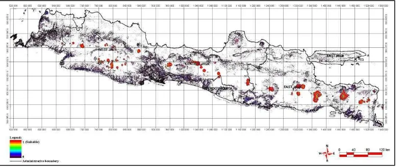
Figure 2.Predicted probability of JHE distribution in Java Island (extrapolation) based on ALR _50 model.
Subsequently, a habitat suitability model (Figure 3) was obtained from thresholding the predicted probability of JHE distribution at 0.5, and then the historical localities record after 1980 was overlaid to this model. Suitable habitat based on ALR_50 model covered about 3,107 km2 and distributed in entire Java Island.
Figure 3. Habitat suitability model of JHE in Java Island (extrapolation) based on threshold of ALR_50 model at 0.5.
3.2 Population Estimation
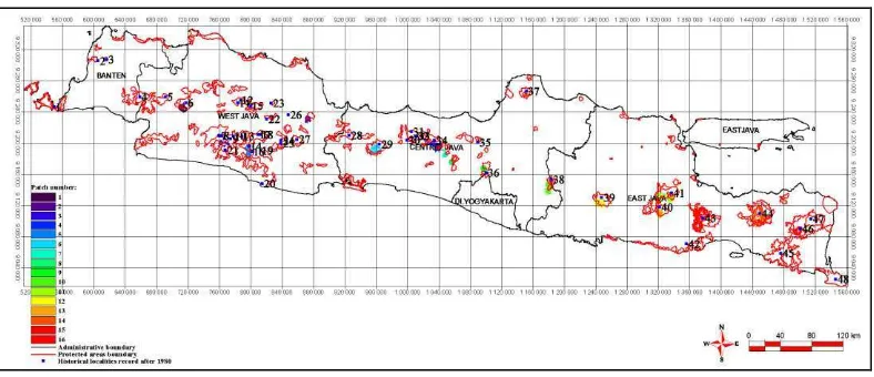
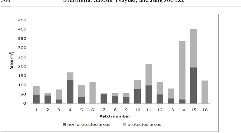
Figure 4. Distribution of habitat patches of JHE in Java Island.Comparing this to the protected area network which is produced by World Conservation Monitoring Centre in 1996, we found that 60.4% (1,309 km2) of the habitat patches already existed inside the protected area network (Figure 5).
Figure 5. Proportion area of habitat patches which located inside and outside protected area network.
The estimated number of pairs per habitat patch based on ALR_50 model is presented in Table 2. In this study, the estimated number of JHE pairs using ALR_50 model extrapolation would place the population size about 108-542 (median = 325) pairs. Estimated population was obtained in this study compare to other studies is presented in Table 3.
Table 2. Habitat patches and population estimation of JHE in Java Island
Patch number
Location Prov. Area
(km2)
Edge (km)
Estimated population (pair) Minimum homerange
Maximum homerange
1 Mt. Gede-Pangrango WJ 95 128 24 5
2 Mt. Cireme WJ 56 73 14 3
3 Mt. Simpang-Mt.Tilu WJ 75 180 19 4
4 Mts. Dieng (Mt.Kemulan) WJ 167 218 42 8
5 Mt. Papandayan WJ 100 108 25 5
6 Mt. Slamet CJ 112 137 28 6
7 Mts Dieng(Mt.Sumbing) CJ 54 62 14 3
8 Mts Dieng (Mt.Sindoro) CJ 55 55 14 3
9 Mts Merapi-Merbabu CJ 55 54 14 3
10 Mt. Lawu CJ 127 165 32 6
11 Mt. Arjuno-Welirang EJ 212 312 53 11
12 Mt. Liman-Wilis EJ 117 193 29 6
Table 2. (continued)
14 Yang highlands EJ 336 666 84 17
15 Mts. Bromo Tengger Semeru National Park
EJ 401 577 100 20
16 Mt. Raung EJ 123 168 31 6
Sum 2166 3185 542 108
Mean 135
Median 325
Note: Prov, Province; WJ, West Java; CJ, Central Java; EJ, East Java.
Table 3.Estimated population of JHE in Java Island based on ALR_50 model and other studies
Source
Estimated population
Pairs Median
ALR_50 model (this study) 108-542 325
Gjershaug et al. (2004) 270-600 435
van Balen et al. (1999, 2000, 2001) 137-188 -
Sözer and Nijman (1995) 81-108 -
van Balen and Meyburg (1994) 67-81 -
Meyburg et al. (1989) 60 -
4.
D
ISCUSSIONFor conservation and development planning, it is often necessary to evaluate a large area for possible alternatives/strategies. Landscape-scale models are effective for generating spatial distributions of potential and present habitat suitability for JHE over a large area using GIS and remote sensing-based data. The predicted probability of habitat suitability may not always be accurate at specific locations because probability itself does not mean present existence. However, they will provide critical information for research, planning, and management needs at landscape scales [22, 23]. Compared to corresponding nest-site scale models, landscape-scale models use coarser information that is acquired from satellite remote sensed data such as MODIS NDVI 250 m of data resolution.
Three locations (Leuweung Sancang Wildlife Reserve (locality number: 20), Mt. Tampomas (No. 23), and Mt. Jagat (No. 26) located in southern parts of West Java were also recognized as omission error in model validation. The other three locations (Ujung Kulon National Park (No.1), Meru Betiri National Park (No.45), and Alas Purwo National Park (No.48)) are known as the relatively large remaining lowland forest area in Java Island [1]. Before World War II, the forest area in Meru Betiri National Park was continuous with those in Alas Purwo National Park to the east, but agricultural developments have now severed this link [1]. The last location, Mt. Cupu/Simembut (No.30) where the small fragments of natural forest remain is located at 350–1,000 m elevation and surrounded by either open ground or pine plantation [17]. The last observation in seven locations mentioned above was conducted in 1997, and undoubtedly all these locations have experienced similar threats, including forest conversion (illegal logging and agricultural expansion), illegal hunting, and isolation from other patches.
In recent years, the wide recognition of the effects that both threatening processes and climate change have on biological diversity, has enhanced the importance of acquiring knowledge on the patterns of species diversity [24]. Moreover, an understanding of the environmental factors that favor key species can guide the management of protected areas [25]. The categorization of habitat quality displayed in the spatial model can be used to prioritise areas requiring protection based on their value. This statement is made on the premise that the probability of species presence is positively correlated with the quality of the habitat [12]. Our model showed that 60.4% of habitat patches existed inside the protected areas and the remaining area extends far outside protected areas. The role of this area for the expansion of the JHE population is likely important. More attention should be paid to this evidence by several agencies (i.e. ministries, national parks, NGOs) to formulate a JHE conservation plan and to identify urgent conservation actions. Therefore, the result of this study may help to proactively manage habitat for JHE, providing the impact of harmful activities within the area to JHE habitat is assessed on a multi-level management scale.
These habitat distribution models were developed based on currently available and thus limited information. New knowledge gained in the future on the habitat requirements for this species may alter the assumptions for the habitat models. Efforts need to be made to update these models whenever new information on the habitat requirements of JHE becomes available. These models and associated documentation that synthesize the biology and ecology of the JHE provide a framework that will make the effort to update the knowledge and models effective.
The landscape-scale models based on extrapolation of the site-scale model provide spatial explicit assessment of the potential and present habitat suitability at the scales of the greatest practical needs. These models provide effective tools for conservation and development planning as well as monitoring and management of JHE habitat.
A
CKNOWLEDGEMENTSThe authors wish to express sincere thanks to the directors and staff of Gunung Gede-Pangrango National Park (TNGP) for granting permission to carry out surveys in TNGP. We are grateful to the Raptor Conservation Society (RCS) and Indigenous Nature Conservation Society (YPAL), especially to Mr. Usep Suparman, Mr. Zaini Rakhman for sharing information on breeding data and their guidance during field surveys. This study was partially supported by The JSPS-DGHE Core University Program on Applied Biosciences between Bogor Agricultural University (IPB)/The University of Tokyo
.
R
EFERENCES1 Whitten, T., Soeriaatmadja, R.E., Afiff, S.A. (1996). The ecology of Java and Bali: the ecology of Indonesia series, Vol. 2. Singapore: Periplus Editions.
2 BirdLife International. (2000). Threatened birds of the world. Barcelona Spain: Lynx Edicions and BirdLife International.
3 BirdLife International. (2001). Threatened birds of Asia: the BirdLife International red data book. Cambridge, U.K: BirdLife International.
4 Meyburg, B-U., van Balen, S., Thiollay, J-M., Chancelllor, R.D. (1989). Observations on the endangered Javan Hawk Eagle Spizaetus bartelsi. In Meyburg, B-U., & Chancellor, R.D. (Eds.), Raptors in the modern world (pp. 279-299). Berlin, London and Paris: WWGBP.
5 van Balen, S., & Meyburg, B-U. (1994). The Javan Hawk Eagle Spizaetus bartelsi: results of recent research on distribution, status and ecology. In Meyburg, B-U., & Chancellor, R.D. (Eds.) Raptor Conservation Today (pp. 89-92). Berlin, London and Paris: WWGBP and The Pica Press.
6 Sözer, R., & Nijman, V. (1995). Behavioral ecology, distribution and conservation of the Javan Hawk Eagle Spizaetus bartelsi Stresemann, 1924. Versl. Techn. Gegev., 62, 1-122.
7 Gjershaug, J.O., Røv, N., Nygård, T. (2004). Home-range size of the Javan Hawk-Eagle (Spizaetus bartelsi) estimated from direct observations and radiotelemetry. Journal of Raptor Research, 38, 343-349.
8 Osborne, P.E., Alonso, J.C., Bryant, R.G. (2001). Modelling landscape-scale habitat use using GIS and remote sensing: a case study with great bustards. Journal of Applied Ecology, 38, 458-471.
10 Engler, R., Guisan, A., Rechsteiner, L. (2004). An improved approach for predicting the distribution of rare and endangered species from occurrence and pseudo-absence. Journal of Applied Ecology, 41, 263-274.
11 Syartinilia, & Tsuyuki, S. (2008). GIS-based modeling of Javan Hawk-Eagle distribution using logistic and autologistic regression models. Biological Conservation, 141, 756-769.
12 Gibson, L.A., Wilson, B.A., Aberton, J.G. (2004). Landscape characteristics associated with species richness and occurrence of small native mammals inhabiting a coastal heathland: a spatial modeling approach. Biological Conservation, 120, 75-89.
13 Posillico, M., Meriggi, A., Pagnin, E., Lovari, S., Russo, L. (2004). A habitat model for brown bear conservation and land use planning in the central Apennines. Biological Conservation, 118, 141-150.
14 BPS, Bappenas, UNFPA. (2005). Indonesia population projection 2000-2025. Indonesia: BPS, Bappenas, and UNFPA.
15 Siebert, L., & Simkin, T. (2002). Volcanoes of the World: an Illustrated Catalog of Holocene Volcanoes and their Eruptions. 2002 [May, 2005]. Available from: URL: http://www.volcano.si.edu/world/.
16 Setiadi, A.P., Rakhman, Z., Nurwatha, P.F., Muchtar, M., Raharjaningtrah, W., 2000. Status, distribution, population, ecology and conservation Javan Hawk-eagle Spizaetus bartelsi Stresemann, 1924 on southern part of west Java. Final Report BP/FFI/BirdLife International/YPAL-HIMBIO UNPAD, Bandung.
17 van Balen, S., Nijman,V., Sözer, R. (1999). Distribution and conservation of the Javan Hawk-eagle Spizaetus bartelsi. Bird Conservation International, 9, 333-349.
18 van Balen, S., Nijman,V., Sözer, R. (2001). Conservation of the endemic Javan hawk-eagle Spizaetus bartelsi Stresemann, 1924 (Aves: Falconiformes): density, age-structure and population numbers. Contributions to Zoology, 70, 161-173.
19 Suparman, U. (2005). Konservasi Elang Jawa Spizaetus bartelsi Stresemann, 1924 di cagar alam Telaga Warna, Puncak 2000-2005: status, distribusi, ekologi dan aksi konservasi. Cianjur, Indonesia: Raptor Conservation Society.
20 Thiollay, J.-M., & Meyburg, B.-U. (1988). Forest fragmentation and conservation of raptors: survey on the Island of Java. Biological Conservation, 44, 229-250.
21 van Balen, S., Nijman,V., Prins, H.H.T. (2000). The javan hawk-eagle: misconceptions about rareness and threat. Biological Conservation, 96, 297-304.
22 Lindenmayer, D.B., & Possingham, H.P. (1996). Modeling the inter-relationship between habitat patchiness, dispersal capability and metapopulation persistence of the endangered species, Leadbeater’s possum in south-eastern Australia. Landscape ecology, 11(2), 79-105.
23 Wu, X.B., Smeins, F.E. (2000). Multiple-scale habitat modeling approach for rare plant conservation. Landscape and Urban Planning, 51, 11-28.
24 Heaney, L.R. (2001). Small mammal diversity along elevational gradients in the Philippines: an assessment of patterns and hypotheses. Global Ecology and Biogeography, 10, 15–39.
Editor: John D. Harris and Paul L. Brown ©2009 Nova Science Publishers, Inc.
GIS-BASED HABITAT MODEL OF JAVAN
HAWK-EAGLE (
S
PIZAETUS
B
ARTELSI)
USING INDUCTIVE APPROACH IN JAVA ISLAND,
INDONESIA
Syartinilia
*a, Satoshi Tsuyuki
†b, and Jung soo Lee
‡ca
Landscape Architecture Department, Faculty of Agriculture, Bogor Agricultural University (IPB).
Jl. Meranti, Kampus IPB, Darmaga - Bogor 16680, Indonesia. b
Graduate School of Agricultural and Life Sciences, The University of Tokyo,
1-1-1 Yayoi, Bunkyo-ku, Tokyo 113-8657, Japan. c
Division of forest management and landscape architecture, College of forest and environmental sciences, Kangwon National University, chunchon.kanwon-do200-701, Korea.
A
BSTRACTThe Javan Hawk-Eagle (JHE) is categorized in the IUCN Red List of Threatened
Species (CITES Appendix 2) as one of the world’s rarest and most endangered raptors in
the remaining original natural forests of Java, Indonesia. Since it is not feasible to conduct complete field surveys for a landscape-scale, this paper proposes a GIS-based extrapolation model based on local-scale model in order to generate a map of potential and present habitat suitability for JHE in the entire landscape. Using autologistic regression, we developed a GIS-based habitat model for JHE in Java Island and subsequently estimated the population number of JHE. The obtained model will be the most useful for the wildlife management conservation planning process in order to help
identify “hot spots” that are most likely to harbor JHE. Most of the predicted suitable habitats in Java Island are distributed in the mountainous area. The area with the largest proportion of suitable habitat for JHE is located in East Java, and then followed by West Java and the last in Central Java. Totally, about 41 locations (85%) of 48 historical localities recorded were recognized as suitable habitat. The estimated number of JHE pairs based on model extrapolation would place the population size about 108-542 (median = 325) pairs. Although this estimated population is higher compared to other
*
E-mail: [email protected] ; [email protected] †
E-mail: [email protected] ‡