Delineation of Flood Hazard Zones by Using a Multi Criteria
Evaluation Approach in Padang West Sumatera Indonesia
Iswandi U1*, Widiatmaka2, Bambang Pramudya3, Baba Barus2
1. Study Program of Natural Resources and Environmental Management, Graduate School, Bogor Agricultural University, Baranang Siang Campus, Pajajaran Street, Bogor 40173, Indonesia
2. Department of Soil Science and Land Resources, Bogor Agricultural University, Bogor, Indonesia 3. Professor of Management Systems and Agricultural Mechanization,Bogor Agricultural University,
Bogor, Indonesia Abstract
In Indonesia flood disasters constitute natural disasters that often occur and have resulted in substantial losses to human life. Mitigation is the important measure to determine hazard flood zones. To determine the weight and rate, the Analysis Hierarchy Process (AHP), Geographical Information System (GIS) are used for overlay analysis. Upon assessment by experts, the research findings reveal that elevation is the highest weight, that is 24%; flood frequency is the lowest weight, that is 7,4%. Further, the analysis result on the flood hazard level in the research area, based on the hazard level class, reveals as follows: a) an area of 8,351.6 ha (12%) includes the high hazard zone; b) an area of 11,378.7 ha (16%) is the moderate hazard zone; and c) an area of 49,738.8 ha (72%) is the low hazard zone.
Key words: delineation, harzad flood area, mitigation.
1. Introduction
Disaster is an event or a series of events that threatens and disrupts public lives and livelihoods caused either by natural and/or non-natural factors or man-made factors, and claims lives, environmental damage, loss of assets, and psychological impact (Law No. 24 of 2007). In addition, according to Wardhono et al. (2012), a flood disaster may result in huge damage to social and economic lives of the people. Asdak (1995) claims that there are three factors that contribute to flood, that are meteorology, watershed physical characteristics and humans. Popovska et al. (2010) claim that flood is caused by rainfall intensity. Furthermore, according to Penning-Rowsell (2003), flood occurs due to lack of control over land use, especially in the catchment zones and watersheds. Yüksek et al. (2013) claim that humans are the significant factor that contribute to disasters for their misuse of land, deforestation, urbanization, and settlements.
According to Sadyohutomo (2008) increases in population and life quality has led to the increases in needs to land use. According to Kodoatie (2013) change of land use into urban solid has posed impacts on the flood increasing because of decreased open space to act as catchment zones. Pribadi et al. (2006) claims that the thriving development has contributed to the change in the scheme of land use where the solid space has increasingly expanded and removed natural space to change its functions. This phenomenon commonly occurs in urban zones where changes in land use are taking place dynamically.
Jha et al. (2011) have observed that several cities in the world are risky to flood hazard. The current existing flood hazard level calls for urgency to prepare the flood risk management in the urban residential zones. According to Popovska et al. (2010) the most appropriate effort to minimize flood hazard and loss incurred is to make a flood hazard zoning map. In the research area from 1988 to 2008 land was actively covered. The urban solid (settlements) has been continuously expanding, where the catchment zones are conversely becoming shrunk from year to year. The green void space in the research areas were 66.339 ha in 1988 and has shrunk to 59.328 ha in 1998 and 52.888 ha in 2008. So, from 1988 to 2008 the green void space in cities has converted to solid space by 13,451 ha. The objectives of this research are therefore to delineate and determine the mitigation policy dedicated to flood hazard settlements.
2. Methodology
2.1. Research Site and Time
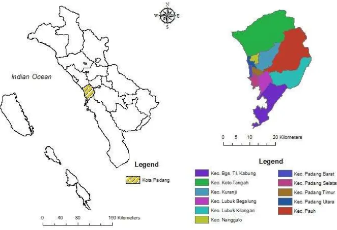
geographical coordinates: 100º05’05’–100º34’09’’ E and 00º44’00’’-01º08’35’’ S. The research area are 69496 ha. The research location can be viewed in Figure 1.
Figure 1. The Research Location in Padang West Sumatera Indonesia
2.2.Data Types and Source
This research requires some data derived from the relevant agencies. In making maps using ArcGIS 10.1 software. and for the analysis of expert opinion using Expert Choice 11 software.
Table 1. Data types, sources, and data output
Data types Sources Data output
Soil type Land Research Center Bogor (1990) scale 1 : 250.000
Soil type map
Slopes Agency Coordination of National Surveying and Mapping (1977) topographic map scale 1 : 50.000
Slopes map
Land use Landsad ETM 7 Land use map
Rainfall data Meteorology Climatology and Geophysics Council Tabing Padang (2013)
Rainfall map
Elevation Shuttle Radar Topography Mission (SRTM) generated Digital Elevation Model (DEM)
Elevation map
Frequency Flood Regional Disaster Management Agency Kota Padang Frequency flood map Landforms Departements of Geography Faculty of Social Sciences UNP
Padang
Landforms map
Table 2. Criteria for Judgment using the AHP Method
Value Description
1 A is equally important to B 3 A is slightly more important than B 5 A is more important than B
7 A is strongly more important than B 9 A is absolutely more important than B
2, 4, 6, 8 Intermediate values between the two adjacent judgments Sources: Saaty (1983), Marimin dan Maghfiroh (2010)
To determine the flood hazard interval class, we use equation, that is equation 1 as introduced by Dibyosaputro (1999).
(1) Whereby:
I : the number of distance interval class
c : the number of highest score
b : the number of lowest score k : the number of class desired 3. Results and Discussion 3.1. Characteristics Research Area
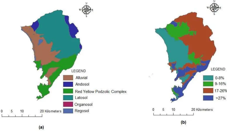
According to the Land Research Center Bogor (1990) soil type map scale of 1: 250,000 categorizing soil types: alluvial soil (13.8%), ground andosol (39.9%), ground latosol (25.5%), ground regosol (9%), ground organosol (0.3%), and the complex of red-yellow podzolic soil (11.5%). Furthermore, the slope generated from the topographic map in the study area can be divided into four categories, namely: the slopes of 0-8% with an area of 17.613,9 ha (25%), the slopes of 9-16% with an area of 10.373,2 ha (14.93% ), the slopes of 17-26% with an area of 31.559 ha (45.41%), and a slope of more than 27% with an area of 9.949,9 ha (14.32%). Distribution of soil type and slope in the study area can be seen in Figure 2.
Figure .
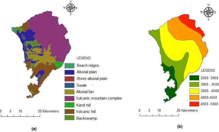
Soil type (a), and slope (b) in the study areaGeomorphological characteristics of the study area can be divided into: backswamp, coastal alluvial plain, between the beach plains, flood plains, shoals beach, sand spit, pyroclastic flow fan, fan fluvio volcanic, mountainous complex volkan, limestone hills, volcanic hills, and natural levee. Based on the landforms can be
distinguished on the hills of volcanic landforms, marine complex landform, landforms tombolo, alluvial landform, landforms marsh behind, and landforms coastal alluvial plains. Volkan complex landform mountains are landforms of the most dominant area of research, which has tilted up a steep slope and the slope shape concave, convex, and complex. Rainfall is a climate that is very important element in influencing the occurrence of floods. Rainfall data from five stations rainfall in the study period 1975 - 2012 the average amount of rainfall that is 3,683 mm/year. The average amount of the highest rainfall occurs in November, while the lowest amount of rainfall occurs in February. Based on the map of rainfall in the study were mostly rainfall intensity 3500 - 4000 mm/year. Rainfall data of the average area of research the period 1975 - 2012 showed decreased over time. Average rainfall area of research the period 1975 - 2012 which is 3.789,8 mm/year. The highest rainfall intensity 6054,26 mm/year in 1981, while rainfall intensity terentah amounted to 2065,5 mm/year in 1997. Fluctuating rainfall in the period 1975 -2012 research can be seen in Figure 3, and distribution of rainfall is shown in Figure 4.
Figure 3. Graph average rainfall (a), and graph fluctuating rainfall period 1975-2012 (b) in the study area
Figure 4. Landform (a), and distribution of rainfall (b) in the study area
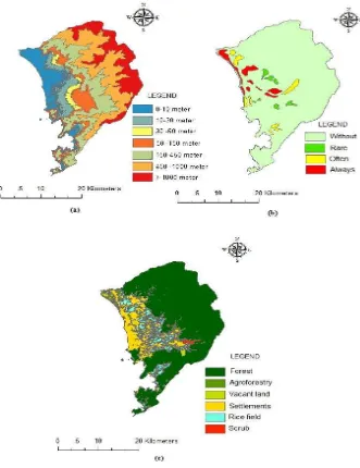
described the frequency of flooding in the area of research in three categories: 3,3% of the study area is always flooded (more than 6 times a year), 2,6% are region of frequent flooding (4-6 times a year), 1,4% are rarely flooded area (less than 4 times a year), and 92.7% are areas without flooding. Furthermore, land use resulting from the research area Landsad ETM image interpretation in 2014 and distinguished six types of uses were: residential (16,5%), paddy (9,3%), mixed farms (3,8%), shrubs (0,6%), vacant land (0,6%), and forests (69,3%). Distribution of elevation, the frequency of flooding and land use in the study area can be seen in Figure 5.
Figure 5. Elevation (a), frequency of flooding (b), and land use (c) in the study area
3.2. Flood Hazard Analysis
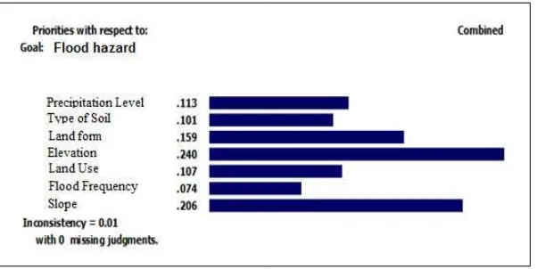
(10.1%), form of soil (15.9%), and land use (10,7%). The lowest weight value is flood frequency by 7.4%. The distribution of experts’ assessment in determining the weight value can be viewed in Figure 6.
Figure 6. The result of experts’ assessment in determining the weight of flood hazard
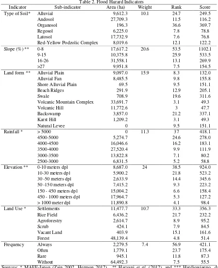
Table 2. Flood Hazard Indicators
Indicator Sub-indicator Area (ha) Weight Rank Score
Type of Soil* Alluvial 9,612.3 10.1 24.7 249.5
Andosol 27,709.3 11.5 116.2
Organosol 196.3 36.6 369.7
Regosol 6,225.0 7.8 78.8
Latosol 17,732.9 7.6 76.8
Red-Yellow Podzolic Complex 8,019.6 12.1 122.2
Slope (%) ** 0-8 17,617.2 20.6 53.5 1102.1
Volcanic Mountain Complex 33,691.7 3.1 49.3
Table 3. Flood Hazard Interval Class
Hazard Class Interval Class Hazard Index
Low Class 543 - 1582,4 Low Hazard Zone
Moderate Class 1582,5 - 2621,8 Moderate Hazard Zone
High Class 2621,9 - 3661,3 High Hazard Zone
According to Stoica dan Iancu (2011) flood hazard zones can be determined by using the geospatial model with the GIS system. Karmakar et al. (2010) use data on land use, morphology, and urban infrastructure as input data to produce flood hazard. According to Miharja et al. (2013) to determine a flood hazard zone, several maps must be overlaid, including: a) type of soil map; b) slope map; c) land form map; d) rainfall map; e) elevation or height map; f) land use map; and g) flood frequency map.
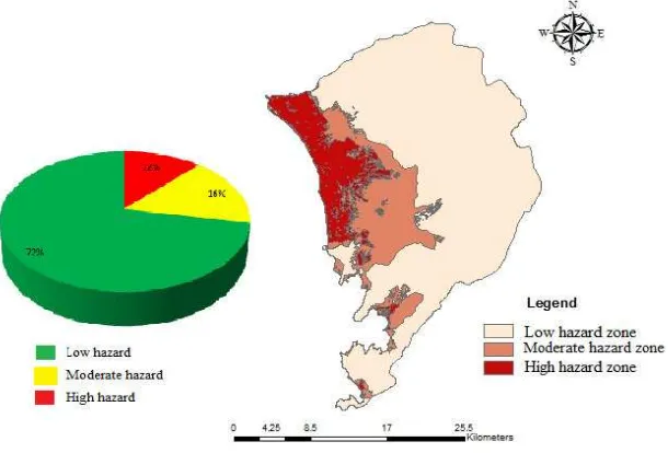
The result of analysis of flood hazard level in the research area based on the flood hazard class shows that: a) an area of 8,351.6 ha includes a high hazard zone; b) an area of 11,378.7 ha includes a moderate hazard zone; and c) an area of 49,738.8 ha includes a low hazard zone. Distribution of flood hazard zones in the research area may be viewed on the flood hazard level map (Figure 8).
Figure 8. Flood hazard level map in study area
4. Conclusion
From the foregoing, it is concluded that the result of experts’ assessment in determining the weight of hazard shows the highest weight is elevation (24%), whereas the lowest weight is flood frequency (7.4%). Further, the result of analysis of flood hazard level in the research area based on flood hazard class shows: a) an area of 8,351.6 ha (12%) includes the high hazard zone; b) an area of 11,378.7 ha (16%) is the moderate hazard zone; and c) an area of 49,738.8 ha (72%) is the low hazard zone.
References
Asdak C. 1995.Hydrology and Watershed Management. Yogyakarta (ID): Gadjah Mada University Pr. Dibyosaputro.1999. Avalanche Land in District Samigaluh Kulon Progo.Yogyakarta: Geography Magazine
Indonesia. 5: 75-81.
Hardjowigeno S, Widiatmaka. 2007.Land Suitability Evaluation and Planning Land Classification Land.
Haryani NS, Zubaidah A, Dirgahayu D, Yulianto HF, Pasaribu J. 2012. Flood Hazards Model Using Remote Sensing Data in Sampang. Journal of Remote Sensing, 9(1): 52-66.
Hermon D. 2012.Disaster Mitigation Hydrology. Padang (ID): Universitas Negeri Padang Pr.
Jha AK, Robin B, Jessica L. 2011.Urban and Flood Management Guide for Flood Risk in the 21st Century.
Thailand (ID): NDM Institut Pr
Karmakar S, Simonovic S, Peck A, Black J. 2010. An Information System for Risk-Vulnerability Assessment to Flood. Journal of Geographic Information System, 2(3): 129-146.
Kodoatie R. 2013.Engineering and Flood City. Yogyakarta (ID): ANDI Pr.
Marimin, Maghfiroh N. 2010.Application Decision Making Techniques in Supply Chain Management. Bogor (ID): IPB Pr.
Miharja N, Panjaitan SD, Sumiyattinah. 2013.Vulnerability Analysis and Risk Reduction Flood In West Kalimantan Based Geographic Information System (GIS). Civil Engineering Untan Journal, 13: 176-196.
Penning-Rowsell E. 2003. Flood Hazard Response in Argentina. Geographical Review, 86(1): 72-90. Popovska C, Jovanovski M, Ivanoski D, Pesevski I. 2010. Storm Sewer System Analysis In Urban Areas and
Flood Risk Assessment. Technical University of Civil Engineering from Bucharest.
Pribadi D, Shiddiq D, Ermyanila M. 2006. Model Land Cover Changes and Affecting Factors. Environmental Technology Journal. Fitness Assessment and Application of Environmental Technology.3 (1): 77-91. Sadyohutomo M. 2008.Management and Regional Realities and Challenges. Jakarta (ID): Bumi Aksara Pr. Stoica A, Iancu I. 2011. Flood Vulnerability Assesment Based On Mathematical Modeling. Technical University
of Civil Engineering from Bucharest.
[UU] Undang-Undang Number 4/2007 about Disaster.
Wardhono A, Pratomo G, Prakoso B, Qori'ah C. 2012. Countermeasures Flood Disaster Sampean River Policy in Situbondo District. Law and Social Sciences Journal(JLSS), 2(1): 118-122.
Yüksek O, Kankal M, Üçüncü O. 2013. Assessment of Big Floods in the Eastern Black Sea Basin of Turkey.
Environmental Monitoring and Assessment Journal, 185(1): 797-814.