SPATIAL MULTI CRITERIA LAND EVALUATION
AND REMOTE SENSING FOR AREA DELINEATION
OF SHRIMP POND CULTURE REVITALIZATION
IN MAHAKAM DELTA, INDONESIA
Widiatmaka1,*), Wiwin Ambarwulan2), Bambang Riadi2), Irmadi Nahib2), Syarif Budhiman3),andAbdul Halim4)
1)
Dept. of Soil Science and Land Resources, Bogor Agricultural University, Indonesia
2)
Geospatial Information Agency, Indonesia
3)
National Institute of Aeronautics and Space, Indonesia
4)
Alumny, Dept. of Soil Science, Bogor Agricultural University, Indonesia * Email: [email protected]; [email protected]
ABSTRACT
Shrimp pond culture revitalization needs an indication of suitable location. This study use Geographic Information System (GIS) - based multi criteria land evaluation and remote sensing for delineate recommended location for shrimp pond culture revitalization in Mahakam Delta, Indonesia. The first step of the study consist of analyzing suitable location. An Analytical Hierarchy Process was conducted in order to obtain the weight of thematic layers. The thematic layers used were consisted of soil characteristics theme (pH, texture, and base saturation), climatic theme (rain fall), topographic theme (elevation and slope), and water quality theme (water pH, dissolved oxygen, nitrate, and salinity). The thematic layers were analyzed using ArcGIS 10.1 to develop a series of GIS models. A weighted overlay was realized to delineate the suitable area for shrimp pond culture. The result indicate that there is some area of highly suitable and moderately suitable for shrimp pond culture in Mahakam Delta. At the second step, land cover map, interpreted from Landsat-8 satellite imagery was used to define the constraint of land utilization. A recommendation map for shrimp pond culture was then could be developed by overlaying suitability map and land use map.
Keywords: analytical hierarchy process, Geographic Information System, land suitability, Landsat-8 imagery
1. INTRODUCTION
As an island country, fisheries are one of the important sectors in Indonesia. Shrimp is one of the important commodities in this sector. Indonesian shrimp farming ever recorded the golden era in the 1980s, characterized by excellent exports of windu prawn, accounted for 15% of total exports of non-oil and gas each year. In the period of 1985-1988 for example, there was an increase in shrimp exports of 30,800 tons, valued at 202.3 million USD to 56,552 tones valued at 499.85 million USD (Grahadyarini, 2014).
shrimp (Anonymous, 2012). In 2012, the revitalization was done on shrimp farms in 6 regency along the northern coast of Java Island (Anonymous, 2012).
This revitalization efforts need also to be done in other areas in Indonesia, including outside of Java Island. One of the potential areas for development of shrimp ponds is East Kalimantan Province.
Mahakam Delta, located in East Kalimantan Province, is an area with a dynamic environment, with high land use change. Originally, the Mahakam Delta ecosystem is filled with dense mangroves. Since the introduction of shrimp pond farming, especially during the Asian economic crisis during 1997-2000, many mangrove forests was converted into shrimp pond culture. Nowadays, there are a lot of shrimp pond becomes a not-well maintained environment due to unsatisfactory results. Thus, it is necessary to revitalize such culture for economic reason. On the other hand, shrimp pond culture should be maintained only in highly suitable area, while the non-suitable area should be preserved with mangrove to maintain the environment.
One of the method for site selection for shrimp pond culture is using remote sensing and geographic information system (GIS). The use of remote sensing and GIS can cover a lot of aspects in planning of aquaculture, including the characterization of the nature of land and water, which can then be used to determine the habitat suitability and zoning areas for shrimp farming (Hosain and Das, 2009). Furthermore, GIS has been able to assist the management of shrimp culture through the identification of efficient areas, not only in terms of cultivation, but also in storage, ease of marketing, ease of transport and others (Aronoff, 1989). A lot of planning is very necessary, so that its application in the field can provide good results (Hosain and Das, 2009).
Multi-criteria land evaluation has been widely used to evaluate resource utilization for a particular use. This concept is based on decision-making that are driven by many
factors. These factors were weighted according to its role in the context of decision making. This method has been widely used for determination of the use of resources, for example in the case of the determination of suitable place for waste disposal (Gbanie, et al., 2013; Effat and Hegazy, 2012), location for agricultural purposes (Mendas and Delali, 2012; Ceballos-Silva and Lopez-Blanco, 2003; Akinci et al., 2013), forestry development (Diaz-Balteiro and Romero, 2008), location for energy development (Rahman et al., 2013; Rosso et al., 2014), selection of suitable place for industry (Rikalovic et al., 2014), location for the airport expansion (Vreeker et al., 2002), and many other cases of decision-making.
This study aimed to evaluate the land suitability of Mahakam Delta for shrimp pond culture using multi-criteria land evaluation (MCLE), especially using the physical criteria. Delineation of shrimp revitalization area will then be done by integrating suitable map with land use/land cover data resulted from remote sensing analysis.
2. MATERIAL AND METHOD 2.1 Study Area
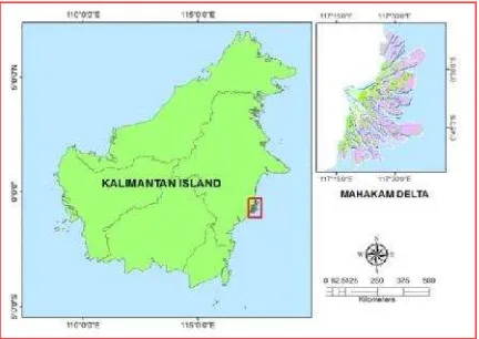
Mahakam Delta is located in East Kalimantan Province, Indonesia, in between
117°15’-117°45’E and 0°15-0°45’S. The
study area includes the area referred as fan alluvium, going to upstream to the relatively more undulated, covering the area of 43,722 ha (Figure 1). According the data of local meteorological station, the climate of this region is monsoon, with annual rain fall ranging from 2,500 to 4,000 mm.year-1. The climate can be classified as Afw according to Koppen climate classification. This type of climate has a tropical rain fall with relatively isothermal hot temperature. Maximum rainy season are April-May and December-January.
indicate that the Mahakam river basin consists of 5 geological formations, however Alluvium (Qa) formation is the most widely spread in Mahakam Delta.
Figure 1. Study area of the Mahakam Delta, East Kalimantan Province, Indonesia
2.2 Data
Data used for this study can be classified into 4 themes, each was consisted in criteria: soil characteristics theme (pH, texture, and base saturation criteria), climatic theme (rain fall criteria), topographic theme (elevation and slope criteria) and water quality theme (water pH, dissolved oxygen, nitrate, and salinity criteria). A survey was conducted in 2011 for soil and water sampling. Soil was analyzed at the Laboratory of the Dept. of Soil Science & Land Resources, Bogor Agricultural University using routine laboratory methods (Tan, 2002). Climatic data was extracted from the spatial data of Indonesian Land Resources Map (Ambarwulanet al., 2006). Topographic data were obtained from Shuttle Radar Topography Mission (SRTM) at accuracy level of 30 m. Water quality data were obtained from laboratory analysis of water samples.
2.3 GIS and Weighted Procedure
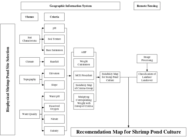
The procedure used to create suitability map is illustrated schematically in Figure 2. The data were classified and weighted according to their contribution to shrimp growth environment. Classification was
based on the bibliographic study and judgment of the authors, classified into 3 levels: 3 (highly suitable), 2 (suitable), and 1 (not suitable) (Table 1).
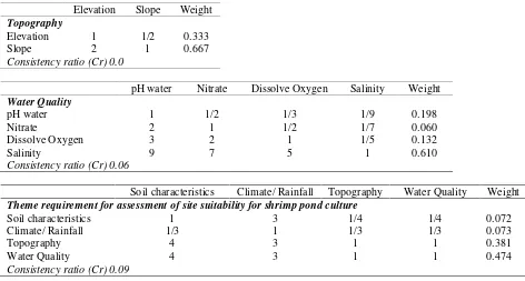
In the next step, the weighting was performed on each criteria and then theme. This procedure is the main procedure in MCLE (Voogd, 1983; Ceballos-Selva and Lopez-Blanco, 2002). Weighting is done by using the Analytical Hierarchy Process (AHP), a concept of Saaty (1988). Although some of the other procedures are available, but this procedure is the most commonly performed in MCLE (Eastman, 1995). The comparison is done by comparing the relative importance of two criteria involved in determining the suitability (Eastman et al., 1995). Ratings were consisted in 9 interests scale, from 9 to 1/9. The value of 9 indicates that line has relatively significantly more important than the column, while the value of ninth show that line has significantly less important than the column. If two variables are equally important, they are given a value of 1. In estimating the weights, an expert or group of experts are asked to compare the matrix in pairs. In this study, the pairwise comparison was developed (Table 2), the consistency ratios (CR) of 0.0–0.09 for the table was well within the ratio of equal to or less than 0,10 recommended by Saaty (1988), signifying a small probability that the weights were developed by chance.
2.4 Land Use and Land Cover Analysis
Bi
Recomendation Map for Shrimp Pond Culture
Remote Sensing Geographic Information System
Figure 2. Research methodology structure
Table 1. Suitability levels of themes (soil characteristic, climate, topography and water quality) for shrimp pond culture in Mahakam Delta
Table 2. A pair-wise comparison matrix for assessing the relative importance of criteria and themes for shrimp ponds culture (numbers show the rating of the row theme relative to the column theme)
pH Texture Base Saturation Weight
Soil Characteristic
pH 1 1/2 1/3 0.164
Texture 2 1 ½ 0.297
Base Saturation 3 2 1 0.539
Consistency ratio (Cr) 0.01
Rainfall Weight
Climate
Rainfall 1 1
Consistency ratio (Cr) 0.0
Criteria Unit
Suitable Range and Score
Elevation Slope Weight
Topography
Elevation 1 1/2 0.333
Slope 2 1 0.667
Consistency ratio (Cr) 0.0
pH water Nitrate Dissolve Oxygen Salinity Weight
Water Quality
pH water 1 1/2 1/3 1/9 0.198
Nitrate 2 1 1/2 1/7 0.060
Dissolve Oxygen 3 2 1 1/5 0.132
Salinity 9 7 5 1 0.610
Consistency ratio (Cr) 0.06
Soil characteristics Climate/ Rainfall Topography Water Quality Weight
Theme requirement for assessment of site suitability for shrimp pond culture
Soil characteristics 1 3 1/4 1/4 0.072
Climate/ Rainfall 1/3 1 1/3 1/3 0.073
Topography 4 3 1 1 0.381
Water Quality 4 3 1 1 0.474
Consistency ratio (Cr) 0.09
3. RESULTS AND DISCUSSION
Results of suitability analysis based on soil characteristics theme is presented in Figure 3. In this figure, each step of soil characteristic theme classification according to each criterion is presented. Soil is the base matrix for ponds and become the initial cost in pond construction. According to soil pH, the area of Mahakam Delta is classified as suitable. Meanwhile, according to soil texture, the majority area (73%) is classified as suitable, while 26% of the area is classified as highly suitable. The suitable texture for ponds construction is fine texture (Hosain and Das, 2010; Hardjowigeno and Widiatmaka, 2007). According to base saturation, 18% of the area is classified as highly suitable, 25% is classified as suitable and 57% is classified as not suitable. When
the weight is applied according to AHP results, in terms of soil characteristic theme, 25% of the area is classified as highly suitable, 75% of the area is classified as suitable and no area of unsuitable for shrimp pond culture (Table 3).
The same process was done for other themes: topographic theme (with the criteria of elevation and slope), water quality theme (with the criteria of dissolve oxygen, salinity, water pH, and nitrate), and climatic theme (with criteria of rain fall) respectively, to obtain the suitability based on each theme. Due to page limitations in this paper, resulted maps of such themes are not presented. Maps are presented directly for the end-product of the suitability map for shrimp ponds (Figure 4).
Table 3. Soil characteristic theme-based areas (ha) and different suitability levels (%) of lands for shrimp pond culture
Criteria Highly Suitable Suitable Not Suitable
Ha % Ha % Ha %
pH - - 93,226.84 100.00 -
-Texture 25,151.44 26.98 68,075.41 73.02 -
-Base Saturation 16,860.34 18.09 23,137.43 24.82 53,229.07 57.10
-Although the theme maps are not presented, to give a brief description however, it can be stated that according to climatic theme, 98.5% of the area is classified as not suitable. This suggests that shrimp pond culture depend more on water availability from rivers and sea water than from rainfall. According to topographic theme (elevation and slope criteria) >95% of
the area is classified as highly suitable for shrimp pond culture. Based on water quality theme (pH, dissolve oxygen, and nitrate-N), most of the area (>80%) is classified as highly suitable, while according to salinity, 53% of the area is classified as not suitable. In sub-overall water quality theme, 47% of the area is classified as highly suitable and 53% of the area is classified as suitable.
Figure 3. Combining soil quality criteria to asses suitability for shrimp pond culture in Mahakam Delta
Figure 4. Combining themes to asses suitability for shrimp pond culture in Mahakam Delta
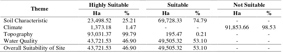
Final suitability map for shrimp pond culture presented in Figure 4 is presented together with Table 4. Such final result show that 47% area in Mahakam Delta is highly
Table 4. The overall theme based areas (ha) and different land suitability area (%) for shrimp pond culture
Theme Highly Suitable Suitable Not Suitable
Ha % Ha % Ha %
Soil Characteristic 23,498.52 25.21 69,728.33 74.79 -
-Climate 1,373.18 1.47 - - 91,853.66 98.53
Topography 93,031.37 99.79 195.47 0.21 -
-Water Quality 43,721.53 46.90 49,505.32 53.10 -
-Overall Suitability of Site 43,721.53 46.90 49,505.32 53.10 -
-Results of the Landsat-8 imagery analysis show 10 kinds of land use/land cover in the Mahakam Delta: primary and secondary mangrove forest, secondary swamp forest, swamp, shrub/swamp, mixed dry land agriculture, bare land, settlement, pond, and water bodies. Of such various land use/land cover, some can be defined as land use that allowed for shrimp pond culture, while some others are not allowed. Therefore, by overlaying the suitability map for shrimp pond culture with the land use map resulting from imagery analysis result, a recommendation map can be developed (Figure 5). In this recommendation map, the classification area is done as follows: (i) area not recommended for pond culture; such area include area where it’s land use does not allow the construction of shrimp pond (e.g. settlements), or because it is not allowed in the context of environmental conservation (forest area), (ii) the most recommended
area; this is the highly suitable area according to its suitability and its land use allows for shrimp pond culture, and (iii) the recommended area; this is the area where the land use allow to development of pond and its land suitability is suitable. The recommendation is presented in Figure 5 and Table 5.
Figure 5. Recommendation map for shrimp pond culture
Table 5. Comparison of land use/ land cover data against the suitability obtained from model and its recommendation
Land use Suitability Ha % Recommendation
4. CONCLUSION
The study was conducted in the Mahakam Delta, East Kalimantan Province, a region where in the past has been widely used for ponds culture, but then suffered a setback, as other shrimp farming area in Indonesia. The study shows that GIS can be used to delineate areas at various levels of suitability for shrimp pond culture. The analysis shows, that 47% of the Mahakam Delta area is highly suitable for shrimp pond culture, while 53% is suitable. Overlay analysis of suitability area with using remote sensing data show, 39% of the area can be defined as most recommended for shrimp pond culture, 35% is recommended, and 26% is not recommended for shrimp pond culture.
During the analysis, it is appeared that the results of the analysis using the MCLE are highly dependent on the quality of the data used. In this study, topographic aspect for example, seems not very sensitive in terms of accuracy. Further studies with more detailed and accurate topographic data are so suggested.
Acknowledgments
Acknowledgement is addressed to Geospatial Information Agency for the funding of field survey during 2011 as well as for facilitation of the imagery analysis. Acknowledgement is addressed also to the Ministry of Research and Technology of the Republic of Indonesia, which has funded the research during 2006 (RUT XII), where the regional spatial data is used in this paper.
References
Akıncı, H., Ozalp, A.Y., and Turgut, B.,
2013. Agricultural Land Use Suitability
Analysis Using GIS and AHP
Technique, Computers and Electronics in Agriculture, Vol. 97, pp. 71–82. Ambarwulan, W., Widiatmaka, Budhiman,
S., and Wijanarto, A.B., 2006. Penggunaan Citra Satelit Multi-Temporal untuk Studi Dinamika Perairan Wilayah Pesisir, Laporan Riset
Unggulan Terpadu XII, Kementerian Riset dan Teknologi (in Indonesian). Anonymous., 2012. Revitalisasi Tambak
Tingkatkan Perekonomian Nasional. Majalah Kelautan dan Perikanan Mina Bahari. Edisi Desember 2012 (in Indonesian).
Aronoff, S., 1989. GIS a Management Perspective.WDLPublications, Ottawa, Canada.
[BAPLAN] Badan Planologi. 2012. Peta Penutupan Lahan, Badan Planologi, Kementerian Kehutanan RI.
Boyd, C. and Zimmermann, S., 2000. Grow-out systems—Water Quality And Soil Management. In: New, M.B., Valenti, W.C. (Eds.), Freshwater Prawn Culture: the Farming of Macrobrachium rosenbergii, Blackwell Science, Oxford, England, pp. 221–238.
Ceballos-Silva, A. and Lopez-Blanco, J., 2003. Delineation of Suitable Areas for Crops Using a Multi Criteria Evaluation
Approach and Land Use/Cover
Mapping: A case study in Central Mexico, Agricultural Systems, Vol. 77, pp. 117–136.
Diaz-Balteiro, L. and Romero, C., 2008. Making Forestry Decisions With Multiple Criteria:aA Review and an Assessment, Forest Ecology and Management, Vol. 255, pp. 3222–3241. Eastman, J.R., Jin, W., Kyem, A.K., and
Toledano, J., 1995. Raster Procedures for Multi-Criteria/Multiobjective
Decisions. Photogrammetric
Engineering and Remote Sensing, Vol. 61 (5), pp. 539–547.
Effat, H.A. and Hegazy, M.N., 2012. Mapping Potential Landfill Sites for North Sinai Cities Using Spatial Multi Criteria Evaluation, The Egyptian Journal of Remote Sensing and Space Sciences, Vol. 15, pp. 125–133.
(MCDA): Case study Bo, Southern Sierra Leone, Applied Geography, Vol. 36, pp. 3-12.
Grahadyarini, B.M.L., 2009. Mengembalikan
Kejayaan Budidaya Udang,
http://bisniskeuangan.kompas.com/read/ 2009/02/25/08375379/Mengembalikan. Kejayaan.Budidaya.Udang, downloaded, March 12, 2014.
Hardjowigeno, S. and Widiatmaka., 2007. Evaluasi Lahan dan Perencanaan
Tataguna Lahan. Gadjahmada
University Press (in Indonesian).
Hossain, M.S. and Das, N.G., 2010. GIS-Based Multi-Criteria Evaluation To Land Suitability Modelling For Giant Prawn (Macrobrachium Rosenbergii) Farming In Companigonj Upazila of Noakhali, Bangladesh, Computers and Electronics in Agriculture, Vol. 70, pp. 172–186.
Mendas, A. and Delali, A., 2012. Integration of Multi Criteria Decision Analysis in GIS to Develop Land Suitability for Agriculture: Application to Durum Wheat Cultivation in The Region of Mleta in Algeria, Computers and Electronics in Agriculture, Vol. 83, pp. 117–126.
New, M.B. (2002). Freshwater prawn farming. a manual for the culture of Macrobrachium rosenbergii, FAO Fisheries Technical Paper 428. Food and Agriculture Organization of the United Nations, Rome, Italy.
Purnomo, A., 1992. Pemilihan Lokasi
Tambak Udang Berwawasan
Lingkungan, Pusat Penelitian dan Pengembangan Perikanan, Jakarta (in Indonesian)
Rahman, M.M., Paatero, J.V., and Lahdelma, R., 2013. Evaluation of Choices for Sustainable Rural Electrification in Developing Countries: a Multi Criteria Approach. Energy Policy, Vol. 59, pp. 589–599.
Rikalovic, A., Cosic, I., and Lazarevic, D., 2014. GIS Based Multi Criteria Analysis for Industrial Site Selection, 24th
DAAAM International Symposium on Intelligent Manufacturing and
Automation, 2013, Procedia
Engineering, Vol. 69, pp. 1054–1063. Rosso, M., Bottero, M., Pomarico, S., La
Ferlita, S., and Comino, E., 2014. Integrating Multi Criteria Evaluation and Stakeholders Analysis for Assessing Hydropower Projects, Energy Policy, Vol. 67, pp. 870–881.
Saaty, T.L., 1988. The Analytic Hierarchy Process, Typesetters Ltd., Becceles, Suffolk.
Supriatna, S., Sukardi, and Rustandi, E., 1995. Peta Geologi Lembar Samarinda, Skala 1:250.000, Pusat Penelitian dan Pengembangan Geologi, Bandung. Tan, K.H., 2000. Soil Sampling, Preparation
and Analysis, Marcel Dekker, New York, NY, USA.
Voogd, H., 1983. Multi criteria Evaluation for Urban and Regional Planning, Pion, London.
Vreeker, R., Nijkamp, P., Welle, C.T. 2002. A Multi Criteria Decision Support Methodology for Evaluation Airport Expansion Plan. Transportation Research, Part D7, pp. 27-47.