Open Geospatial Consortium Inc.
Date: 2010-02-10 Reference number of this document: OGC 06-131r6 Version: 1.0.0
Category: OGC® Implementation Standard Editor(s): Frédéric Houbie, Lorenzo Bigagli
OGC® Catalogue Services Standard 2.0
Extension Package for ebRIM Application Profile:
Earth Observation Products
Copyright © 2010 Open Geospatial Consortium, Inc.
To obtain additional rights of use, visit http://www.opengeospatial.org/legal/.
Warning
Recipients of this document are invited to submit, with their comments, notification of any relevant patent rights of which they are aware and to provide supporting
documentation.
Document type: OGC® Implementation Standard Document subtype: Application Profile
ii Copyright © 2012 Open Geospatial Consortium License Agreement
Permission is hereby granted by the Open Geospatial Consortium, ("Licensor"), free of charge and subject to the terms set forth below, to any person obtaining a copy of this Intellectual Property and any associated documentation, to deal in the Intellectual Property without restriction (except as set forth below), including without limitation the rights to implement, use, copy, modify, merge, publish, distribute, and/or sublicense copies of the Intellectual Property, and to permit persons to whom the Intellectual Property is furnished to do so, provided that all copyright notices on the intellectual property are retained intact and that each person to whom the Intellectual Property is furnished agrees to the terms of this Agreement.
If you modify the Intellectual Property, all copies of the modified Intellectual Property must include, in addition to the above copyright notice, a notice that the Intellectual Property includes modifications that have not been approved or adopted by LICENSOR. THIS LICENSE IS A COPYRIGHT LICENSE ONLY, AND DOES NOT CONVEY ANY RIGHTS UNDER ANY PATENTS THAT MAY BE IN FORCE ANYWHERE IN THE WORLD.
THE INTELLECTUAL PROPERTY IS PROVIDED "AS IS", WITHOUT WARRANTY OF ANY KIND, EXPRESS OR IMPLIED, INCLUDING BUT NOT LIMITED TO THE WARRANTIES OF MERCHANTABILITY, FITNESS FOR A PARTICULAR PURPOSE, AND NONINFRINGEMENT OF THIRD PARTY RIGHTS. THE COPYRIGHT HOLDER OR HOLDERS INCLUDED IN THIS NOTICE DO NOT WARRANT THAT THE FUNCTIONS CONTAINED IN THE INTELLECTUAL PROPERTY WILL MEET YOUR REQUIREMENTS OR THAT THE OPERATION OF THE INTELLECTUAL PROPERTY WILL BE UNINTERRUPTED OR ERROR FREE. ANY USE OF THE INTELLECTUAL PROPERTY SHALL BE MADE ENTIRELY AT THE USER’S OWN RISK. IN NO EVENT SHALL THE COPYRIGHT HOLDER OR ANY CONTRIBUTOR OF INTELLECTUAL PROPERTY RIGHTS TO THE INTELLECTUAL PROPERTY BE LIABLE FOR ANY CLAIM, OR ANY DIRECT, SPECIAL, INDIRECT OR CONSEQUENTIAL DAMAGES, OR ANY DAMAGES WHATSOEVER RESULTING FROM ANY ALLEGED INFRINGEMENT OR ANY LOSS OF USE, DATA OR PROFITS, WHETHER IN AN ACTION OF CONTRACT, NEGLIGENCE OR UNDER ANY OTHER LEGAL THEORY, ARISING OUT OF OR IN CONNECTION WITH THE IMPLEMENTATION, USE, COMMERCIALIZATION OR PERFORMANCE OF THIS INTELLECTUAL PROPERTY. This license is effective until terminated. You may terminate it at any time by destroying the Intellectual Property together with all copies in any form. The license will also terminate if you fail to comply with any term or condition of this Agreement. Except as provided in the following sentence, no such termination of this license shall require the termination of any third party end-user sublicense to the Intellectual Property which is in force as of the date of notice of such termination. In addition, should the Intellectual Property, or the operation of the Intellectual Property, infringe, or in LICENSOR’s sole opinion be likely to infringe, any patent, copyright, trademark or other right of a third party, you agree that LICENSOR, in its sole discretion, may terminate this license without any compensation or liability to you, your licensees or any other party. You agree upon termination of any kind to destroy or cause to be destroyed the Intellectual Property together with all copies in any form, whether held by you or by any third party. Except as contained in this notice, the name of LICENSOR or of any other holder of a copyright in all or part of the Intellectual Property shall not be used in advertising or otherwise to promote the sale, use or other dealings in this Intellectual Property without prior written authorization of LICENSOR or such copyright holder. LICENSOR is and shall at all times be the sole entity that may authorize you or any third party to use certification marks, trademarks or other special designations to indicate compliance with any LICENSOR standards or specifications.
This Agreement is governed by the laws of the Commonwealth of Massachusetts. The application to this Agreement of the United Nations Convention on Contracts for the International Sale of Goods is hereby expressly excluded. In the event any provision of this Agreement shall be deemed unenforceable, void or invalid, such provision shall be modified so as to make it valid and enforceable, and as so modified the entire Agreement shall remain in full force and effect. No decision, action or inaction by LICENSOR shall be construed to be a waiver of any rights or remedies available to it.
ii Copyright © 2010 Open Geospatial Consortium, Inc.
Contents
PageIntroduction ... 1
1 Scope ... 1
2 Compliance ... 1
2.1 Conformance to base specifications ... 1
2.2 Conformance classes of the EO EP ... 2
2.2.1 Conformance class A.1: The core (EOP support) ... 2
2.2.2 Conformance class A.2: SAR Extension ... 2
2.2.3 Conformance class A.3: OPT Extension ... 3
2.2.4 Conformance class A.4: ATM Extension ... 3
2.3 Conformance requirements ... 3
3 Normative references ... 4
4 Terms and definitions ... 5
5 Conventions ... 8
5.1 Abbreviated terms ... 8
5.2 UML notation ... 9
5.3 Used parts of other documents ... 9
6 System context ... 9
6.1 Application domain ... 10
6.2 Essential use cases ... 10
7 Catalogue Infrastructure Overview ... 10
8 Earth Observation Resource Mapping ... 12
8.1 General Information ... 12
8.2 EO Products Metadata Mapping ... 13
8.2.1 Earth Observation Product Types ... 13
8.2.2 ebXML Slot Types Definition ... 15
8.2.3 Mapping Schema Structure ... 17
8.2.4 Acquisition Parameters ... 18
8.2.5 Earth Observation Taxonomy ... 27
8.2.6 Platform, Product and Archiving Metadata ... 29
8.2.7 Grouping the Complete Mapping Schema into a Registry Package ... 41
8.2.8 Thematic and Mission-Specific Metadata ... 41
8.3 RegistryPackage Definition ... 48
8.3.1 Introduction ... 48
8.3.2 RegistryPackage Role ... 48
8.3.3 RegistryPackage Content ... 48
9 EO Products Catalogue External Interfaces ... 55
9.1 Supported Protocol Binding and Available Operations ... 55
9.2 Interface Specifications ... 56
Copyright © 2010 Open Geospatial Consortium, Inc.Copyright
© 2010 Open Geospatial Consortium, Inc. iii
9.2.2 GetRecords Operation ... 59
9.2.3 DescribeRecord Operation ... 69
9.2.4 GetRecordById Operation ... 70
9.2.5 GetRepositoryItem Operation ... 73
9.2.6 Harvest Operation ... 74
10 Implementation Guidance ... 76
10.1 Use of ParentIdentifier ... 76
Annex A: Abstract test suite (normative) ... 77
Annex B: XML Schema Documents (normative) ... 87
Annex C: SOAP 1.1 Implementation (normative) ... 88
C.1 Request ... 88
C.2 Response ... 88
C.3 Error response ... 88
Annex D: Implementation Architectures (informative) ... 89
D.1 Stand-Alone Architecture ... 89
D.2 Proxy Architecture... 90
D.2.1 Front-End Architecture ... 90
D.2.2 Replication Architecture ... 91
D.2.3 ‘Front-End’ vs ‘Replication’ Comparison ... 92
D.3 Distributed Search Implementation ... 93
D.4 Proxy profile ... 93
Annex E: Examples (informative) ... 95
E.1 Service capabilities document ... 95
E.2 GetRecords operation ... 98
E.3 GetRecordById operation ... 108
Annex F: XML RegistryPackage Documents (informative) ... 112
Annex G: Proposed Filter Syntax Compliance Levels (informative) ... 113
G.1 Request Handling ... 114
G.1.1 Part 1: The Collections ... 116
G.1.2 Part 2: Area of Interest ... 117
G.1.3 Part 3: the Earth Observation Products (EOP) queryables. ... 119
G.1.4 Part 4: the classification queryables. ... 124
G.2 Conclusions ... 130
Annex H: Document Change History (informative) ... 131
H.1 Changes with respect to the 0.1.5 Version ... 131
H.2 Changes with respect to the 0.1.6 Version ... 131
H.3 Changes with respect to the 0.1.7 Version ... 132
H.4 Changes with respect to the 0.1.8 Version ... 132
H.5 Changes with respect to the 0.1.9 Version ... 133
H.6 Changes with respect to the 0.2.0 Version ... 133
H.7 Changes with respect to the 0.2.1 Version ... 133
H.8 Changes with respect to the 0.2.2 Version ... 134
H.9 Changes with respect to the 0.2.3 Version ... 135
iv Copyright © 2010 Open Geospatial Consortium, Inc.
Figures
PageFigure 1: UML notations ... 9
Figure 2: General Catalogue Infrastructure ...10
Figure 3: Earth Observation Oriented Catalogue Infrastructure ...11
Figure 4: Relationship between EO Dataset Collections and Datasets ...13
Figure 5 : A layered view of GML EO Products data. ...14
Figure 6: EO Product XML Schemas Structure ...14
Figure 7: Pleiades dataset layered structure ...15
Figure 8: EO Products Mapping Schema Structure ...17
Figure 9: EO Products instance ...18
Figure 10: EO Products instance ...20
Figure 11: EO Product Types Taxonomy ...27
Figure 12: EO Product classified ...29
Figure 13: EO Products additional information ...33
Figure 14: EO Products additional information ...39
Figure 15: Complete EO Products Data Model ...41
Figure 16: EO Data Layers associated to EO Products ...45
Figure 17: Service Interface (CSW-ebRIM) ...56
Figure 18: CSW-discovery.xsd (2.0.2) GetRecords complex type ...63
Figure 19: CSW-discovery.xsd (2.0.2) Query complex type ...64
Figure 20: CSW-discovery.xsd (2.0.2) GetRecordsResponse complex type ...65
Figure 21: CSW-discovery.xsd (2.0.2) GetRecordById complex type ...71
Figure 22: CSW-discovery.xsd (2.0.2) GetRecordByIdResponse complex type ...72
Figure 23: Stand-Alone Architecture ...89
Figure 24: Front-End Architecture...91
Figure 25: Replication Architecture ...92
Figure 26: Implementing distributed search ...93
Copyright © 2010 Open Geospatial Consortium, Inc.Copyright
© 2010 Open Geospatial Consortium, Inc. v
Tables
PageTable 1 — EOProduct Metadata Levels ...12
Table 2 — Slot Types Defintion ...16
Table 3 — EOProduct ExtrinsicObject Correspondence ...21
Table 4 — EOAcquisitionPlatform ExtrinsicObject Correspondence ...34
Table 5 — EOProductInformation ExtrinsicObject Correspondence ...36
Table 6 — EOBrowseInformation ExtrinsicObject Correspondence ...37
Table 7 — EOMaskInformation ExtrinsicObject Correspondence ...38
Table 8 — EOArchivingInformation ExtrinsicObject Correspondence ...40
Table 9 — EOProduct ExtrinsicObject Correspondence ...43
Table 10 — EOProduct ExtrinsicObject Correspondence ...44
Table 11 — EODataLayer ExtrinsicObject Correspondence ...46
Table 12 — Required Operations on ebRIM Catalogue Service ...55
Table 13 — Optional Operation on ebRIM Catalogue Service ...56
Table 14 — Permissible Section Names ...57
Table 15 — GetRecords Operation Parameters ...60
Table 16 — Allowable Catalogue Record Representation ...64
Table 17 — Registry object views ...66
Table 18 — GetRecordById Operation Parameters ...71
Table 19 — GetRepositoryItem Operation Parameters ...73
vi Copyright © 2010 Open Geospatial Consortium, Inc.
Examples
Example 1 – GetRecords query, to fetch ClassificationScheme. ...27
Example 2 – GetRecords query based on acquisition type. ...28
Example 3 – Brief view of the ebRIM Registry Package. ...66
Example 4 – Summary view of an ebRIM registry object. ...66
Example 5 – Full view of the ebRIM Registry Package containing a full EO Product ....67
Example 6 – Harvest Operation Definition in the Capabilies ...75
Example 7 – GetRecords example. ...98
Example 8 – GetRecordsResponse example. ...100
Copyright © 2010 Open Geospatial Consortium, Inc.Copyright
© 2010 Open Geospatial Consortium, Inc. vii
Preface
This document describes the mapping of Earth Observation Products – defined in the OGC® GML 3.1.1 Application schema for Earth Observation products [OGC 06-080r4] (version 0.9.3) – to an ebRIM structure within an OGC® Catalogue 2.0.2 (Corrigendum 2 Release) [OGC 07-006r1] implementing the CSW-ebRIM Registry Service – part 1: ebRIM profile of CSW [OGC 07-110r4].
This standard defines the way Earth Observation products metadata resources are organized and implemented in the Catalogue for discovery, retrieval and management.
i.
Document terms and definitions
This document uses the specification terms defined in Subclause 5.3 of [OGC 05-008], which is based on the ISO/IEC Directives, Part 2. Rules for the structure and drafting of International Standards. In particular, the word “shall” (not “must”) is the verb form used to indicate a requirement to be strictly followed to conform to this specification.
ii.
Submitting organizations
The following organizations submitted the OGC® Earth Observation Extension Package ebRIM profile of CS-W 1.0 to the OGC. The submission team would like to thank all of the members of the Standards Working Group who helped bring this document to OGC adopted standard status.
• ERDAS (was Ionic Software s.a.)
• Spacebel s.a.
viii Copyright © 2010 Open Geospatial Consortium, Inc.
iii.
Document contributor contact points
Questions regarding this document should be directed to the editor or the contributors:
Name Organization Email
Renato Primavera ERDAS renato.primavera<at>erdas.com
Frédéric Houbie (Editor) ERDAS frederic.houbie<at>erdas.com
Luc Donea ERDAS luc.donea<at>erdas.com
Yves Coene Spacebel s.a. Yves.Coene<at>spacebel.be
Samuel Dewaele Spacebel s.a. Samuel.DEWAELE<at>spacebel.be
Jolyon Martin European Space Agency Jolyon.Martin<at>esa.int
Richard Martell Galdos Systems, Inc rmartell<at>galdosinc.com
Darko Androsevic Galdos Systems, Inc dandrosevic<at>galdosinc.com
Jef Vanbockryck Cronos nv jef.vanbockryck<at>cronos.be
Yaman Ustuntas Cronos nv yaman.ustuntas<at>cronos.be
Marie-Lise Vautier IGN France marie-lise.vautier<at>ign.fr
Lorenzo Bigagli (Editor) CNR lorenzo.bigagli<at>cnr.it
Uwe Voges Con terra U.Voges<at>conterra.de
iv.
Revision history
Please see the Annex H for a complete Document Change History.
Date Release Editor Sections modified Description
18/08/2006 0.0.2 R. Primavera Add content Chapter definition, content added. 11/09/2006 0.0.3 R. Primavera Complete revision All chapters revised and content added. 22/01/2007 0.0.4 R. Primavera Integrate reviews All chapters revised and content added. 15/02/2007 0.1.0 R. Primavera Complete revision All chapters revised and content added. 30/04/2007 0.1.1 F. Houbie Update according EO
GML Schemas v0.95
Update of table 3
21/05/2007 0.1.2 F. Houbie EOProduct table Add parentIdentifier property
04/06/2007 0.1.3 F. Houbie EOProduct table Fix mismatch between gml properties and slot names
18/06/2007 0.1.4 S. Dewaele EOResourceMapping Correct xpath expressions 21/09/2007 0.1.5 S. Dewaele EOResourceMapping Put the namespace in the xpath
expressions and correct some xpath errors.
29/10/2007 0.1.6 R. Primavera Complete revision See complete change history in Annex H 11/12/07 0.1.7 R.Smillie
F. Houbie
See complete change history in Annex H
29/01/08 0.1.8 F. Houbie See complete change history in Annex H
14/05/08 0.1.9 S. Dewaele See complete change history in Annex H
25/06/08 0.2.0 F. Houbie See complete change history in Annex H5
23/10/08 0.2.1 F. Houbie See complete change history in Annex H6
12/11/08 0.2.2 F. Houbie See complete change history in Annex H7
Copyright © 2010 Open Geospatial Consortium, Inc.Copyright
© 2010 Open Geospatial Consortium, Inc. ix
01/06/09
0.2.4 F. Houbie See complete change history in Annex H9
25/06/09 0.2.5 L. Bigagli See complete change history in Annex H10
15/01/10 1.0 Carl Reed Various Edit and prepare for publication
v.
Changes to the OGC Abstract Specification
The OGC® Abstract Specification does not require changes to accommodate the technical contents of this document.
vi.
Future work
Future work items include reconsidering the 1:1 mapping between the GML EO structure and the EO Extension Package ebRIM registry and to limit the EO Extension Package to the queryable properties only.
vii.
Foreword
This document has been created based on requirements from the European Space Agency and partners as part of the Heterogeneous Missions Accessibility project. This document is conformant with the [OGC 06-080r4] GML Application Schema for EO Products document (and OGC standard) as proposed by the European Space Agency, the French Space Agency, the European Satellite Center, Spacebel s.a. and Spot Image.
Attention is drawn to the possibility that some of the elements of this document may be the subject of patent rights. The Open Geospatial Consortium Inc. shall not be held responsible for identifying any or all such patent rights.
Copyright © 2010 Open Geospatial Consortium, Inc.Copyright
© 2010 Open Geospatial Consortium, Inc. 1
Introduction
This standard is part of a suite of OGC documents that describe service interfaces and encodings for managing Earth Observation (EO) data products. The services include collection level and product level catalogues, online-ordering for existing and future products, online access, etc.
The service interfaces and operations described in this standard are intended to support the identification of (EO) data products from previously identified data collections. In other words, the search and presentation of metadata from catalogues of EO data products through standard compliant operations. The intent of this profile is to describe a cost-effective interface that can be supported by many data providers (satellite operators, data distributors, etc.), most of whom have existing (and relatively complex) facilities for the management of their EO data.
EO data product collections are usually structured to describe data products derived from a single sensor onboard a satellite or series of satellites. Products from different classes of sensors usually require specific product metadata. The following classes of products have been identified so far: radar, optical, atmospheric. The proposed approach is to identify a common set of elements grouped in a common (EOP) schema and extend this common schema to add sensors specific metadata.
1 Scope
This OGC® standard specifies the Earth Observation Products Extension Package for ebRIM (ISO/TS 15000-3) Application Profile of CSW 2.0, based on the [OGC 06-080r4] OGC™ GML Application Schema for EO Products.
This application profile enables CSW-ebRIM catalogues to handle a variety of metadata pertaining to earth observation, like EO Products defined in [OGC 06-080r4].
This application profile standard describes the interfaces, bindings and encodings required to discover, search and present metadata from catalogues of Earth
Observation products. The profile presents a minimum specification for catalogue interoperability within the EO domain, with extensions for specific classes of data.
2 Compliance
2.1 Conformance to base specifications
An implementation compliant with to this standard shall conform to one of the two levels of conformance to the ebRIM profile of CS-W defined in OGC 07-110r4. As stated in clause 2 of OGC 07-110r4, this conformance statement concerns:
2 Copyright © 2010 Open Geospatial Consortium, Inc. - The applicable requirements in all normative base specifications.
2.2 Conformance classes of the EO EP
This standard defines four levels of conformance. 2.2.1 Conformance class A.1: The core (EOP support)
This conformance class defines test cases for the ebRIM entities (e.g., extrinsic objects, slots, associations and classifications) supported by all Earth Observation products, i.e. those that are mapped to XML elements in the EOP namespace of GML Application Schema for EO Products [OGC 06-080r4, version 0.9.3].
It defines test cases covering:
- Mandatory support of SOAP 1.2; - Availability of the extension package;
- Correct instantiation of the EOP part of the EO Extension Package;
- Correct implementations of the mappings between the EOP properties of the EO GML repository items and the ebRIM registry;
- Correct grouping of the metadata in the EOProduct registry package; - Support of the appropriate parameter values for the GetRepositoryItem
operation;
- Support of the appropriate parameter values for the Harvest operation. NOTE: Support of SOAP 1.2 is optional in the ebRIM profile of CSW (OGC 07-110r4). It is mandatory in this Extension Package. Due to the way the ebRIM profile of CSW’s ATS is structured (cf. ATC 26 to 28 in OGC 08-103r2), it is necessary to include a test case in the ATS of this specification verifying that SOAP 1.2 is
supported by the implementation being tested. Further testing of SOAP capabilities is specified in the CSW ebRIM ATS and needs not be repeated in the ATS of this specification.
2.2.2 Conformance class A.2: SAR Extension
This conformance class extends the Core conformance class by defining test cases for the slots relevant for the Synthetic Aperture Radar (SAR) Earth Observation products, i.e. those that are mapped to XML elements in the SAR namespace of GML
Application Schema for EO Products [OGC 06-080r4, version 0.9.3]. This conformance class defines test cases covering:
Copyright © 2010 Open Geospatial Consortium, Inc.Copyright
© 2010 Open Geospatial Consortium, Inc. 3
- Correct implementations of the mappings between the SAR properties of the EO GML repository items and the ebRIM registry;
- Support of the appropriate parameter values for the Harvest operation. 2.2.3 Conformance class A.3: OPT Extension
This conformance class extends the Core conformance class by defining test cases for the slots relevant for Optical (OPT) Earth Observation products, i.e. those that are mapped to XML elements in the OPT namespace of GML Application Schema for EO Products [OGC 06-080r4, version 0.9.3].
This conformance class defines test cases covering:
- Correct instantiation of the OPT slots of the EO Extension Package;
- Correct implementations of the mappings between the OPT properties of the EO GML repository items and the ebRIM registry;
- Support of the appropriate parameter values for the Harvest operation. 2.2.4 Conformance class A.4: ATM Extension
This conformance class extends the Core conformance class by defining test cases for the slots relevant for the Atmospheric (ATM) Earth Observation products, i.e. those that are mapped to XML elements in the ATM namespace of GML Application Schema for EO Products [OGC 06-080r4, version 0.9.3].
This conformance class defines test cases covering:
- Correct instantiation of the ATM extrinsic object, association and slots of the EO Extension Package;
- Correct implementations of the mappings between the ATM properties of the EO GML repository items and the ebRIM registry;
- Support of the appropriate parameter values for the Harvest operation. 2.3 Conformance requirements
An implementation compliant with this standard shall pass all applicable tests specified in the Abstract Test Suite of the ebRIM profile of CS-W documented in CSW-ebRIM Registry Service – Part 3: Abstract Test Suite (1.0.1) [OGC 08-103]. In complement to this, the implementation shall pass the conformance tests specified in the EO EP Abstract Test Suite (See Annex A) applicable to both the targeted EO EP conformance class and to the conformance level to the ebRIM profile of CS-W, as described in the following table.
EO EP Conformance
Conformance levels of the ebRIM profile of CS-W
4 Copyright © 2010 Open Geospatial Consortium, Inc. classes
A.1 – The Core (EOP support)
A.1.1, A.1.2, A.1.3, A.1.4, A.1.5, A.1.6, A.1.7, A.1.8, A.1.9, A.1.10, A.1.11, A.1.12, A.1.13, A.1.14, A.1.15, A.1.16, A.1.17, A.1.18, A.1.19, A.1.20, A.1.21, A.1.22, A.1.23, A.1.24, A.1.26
A.1.1, A.1.2, A.1.3, A.1.4, A.1.5, A.1.6, A.1.7, A.1.8, A.1.9, A.1.10, A.1.11, A.1.12, A.1.13, A.1.14, A.1.15, A.1.16, A.1.17, A.1.18, A.1.19, A.1.20, A.1.21, A.1.22, A.1.23, A.1.24, A.1.25, A.1.26
A.2 – SAR
Extension A.2.1, A.2.2 A.2.1, A.2.2, A.2.3
A.3 – OPT
Extension A.3.1, A.3.2 A.3.1, A.3.2, A.3.3
A.4 – ATM
Extension A.4.1, A.4.2, A.4.3 A.4.1, A.4.2, A.4.3, A.4.4
3 Normative references
Parts of the following normative documents are referenced in this text. For dated references, subsequent amendments to, or revisions of, any of these publications do not apply. For undated references, the latest edition of the normative document referred to applies.
[ebRIM] OASIS ebXML Registry Information Model Version 3.0
[ISO 19115:2003] Geographic information : Metadata
[OGC 04-095] OGC® Filter Encoding Implementation Specification, version 1.1.0, 2005/05/03
[OGC 05-008] OGC® Web Services Common Specification Corrigendum, version 1.0.0, 2005/11/22
[OGC 07-110r4] OGC® CSW-ebRIM Registry Service - Part 1: ebRIM profile of CSW, version 1.0.1, 2009/02/05.
[OGC 07-144r4] OGC® CSW-ebRIM Registry Service – Part 2 : Basic extension package, version 1.0.1, 2009/02/05
[OGC 08-103r2] OGC® CSW-ebRIM Registry Service – Part 3: Abstract Test Suite (1.0.1), version 1.0.1, 2009/02/05
Copyright © 2010 Open Geospatial Consortium, Inc.Copyright
© 2010 Open Geospatial Consortium, Inc. 5
[OGC 07-006r1] OGC® Catalogue Services Specification, version 2.0.2 (Corrigendum 2 Release), 2007/02/23
[OGC 07-092] OGC® Definition identifier URNs in OGC namespace, version 1.3.0, 2006/01/15.
In addition to this document, this specification includes several normative XML Schema Document files as specified in Annex B.
4 Terms and definitions
For the purposes of this specification, the definitions specified in Clause 4 of the [OGC 05-008] OGC® OWS Common Implementation Standard shall apply. In addition, the following terms and definitions apply.
4.1
application profile
see the term “profile” in this list.
4.2
client
software component that can invoke an operation from a server.
data level
stratum within a set of layered levels in which data is recorded that conforms to definitions of types found at the application model level [ISO 19101].
4.3
dataset series (dataset collection1)
collection of datasets sharing the same product specification [ISO 19113, ISO 19114, ISO 19115]. In the earth observation context, a collection typically corresponds to datasets (i.e. products) derived from data acquired by a single sensor onboard a satellite or series of satellites.
4.4
datastrip
a satellite acquisition.
4.5
geographic dataset
dataset with a spatial aspect [ISO 19115].
4.6
geographic information
information concerning phenomena implicitly or explicitly associated with a location relative to the Earth [ISO 19128 draft].
1 Due to historical reasons we will mainly use the term ‘dataset collection’ in this document, although the term
6 Copyright © 2010 Open Geospatial Consortium, Inc.
4.7
georesource
geographic information of a specific type (e.g. geographic dataset, geographic application, geographic service).
4.8
identifier
linguistically independent sequence of characters capable of uniquely and permanently identifying that with which it is associated.
4.9
interface
named set of operations that characterize the behavior of an entity [ISO 19119].
4.10
metadata entity
set of metadata elements describing the same aspect of data.
NOTE 1 May contain one or more metadata entities.
NOTE 2 Equivalent to a class in UML terminology [ISO 19115].
4.11
metadata schema
conceptual schema describing metadata.
NOTE ISO 19115 describes a standard for a metadata schema. [ISO 19101].
4.12
metadata section
subset of metadata that defines a collection of related metadata entities and elements [ISO 19115].
4.13
operation
specification of a transformation or query that an object may be called to execute [ISO 19119].
4.14
parameter
variable whose name and value are included in an operation request or response [ISO 19119].
4.15
profile
set of one or more base standards and – where applicable – the identification of chosen clauses, classes, subsets, options and parameters of those base standards that are necessary for accomplishing a particular function [ISO 19101, ISO 19106].
Copyright © 2010 Open Geospatial Consortium, Inc.Copyright
© 2010 Open Geospatial Consortium, Inc. 7
4.16
qualified name
name that is prefixed with its naming context.
4.17
request
invocation of an operation by a client.
4.18
response
result of an operation, returned from a server to a client.
4.19
schema
formal description of a model [ISO 19101, ISO 19103, ISO 19109, ISO 19118].
4.20
server
service instance
a particular instance of a service [ISO 19128].
4.21
service
distinct part of the functionality that is provided by an entity through interfaces [ISO 19119].
4.22
service interface
shared boundary between an automated system or human being and another automated system or human being [ISO 19101].
4.23
service metadata
metadata describing the operations and geographic information available at a
server [ISO 19128].
4.24 state
(of an object) persistent data object reflecting the internal values of all the member attributes or measurable descriptions of an object at a given time.
NOTE State is usually associated to an object by its identity and to a time by a timestamp [ISO 19132].
4.25
transfer protocol
common set of rules for defining interactions between distributed systems [ISO 19118].
4.26
version
8 Copyright © 2010 Open Geospatial Consortium, Inc.
NOTE An OWS Implementation Specification version may specify XML Schemas against which an XML encoded operation request or response should be validated.
5 Conventions
5.1 Abbreviated terms
Some more frequently used abbreviated terms:
API Application Program Interface
ATM Atmospheric Type (Namespace) BPEL Business Process Execution Language COTS Commercial Off The Shelf
CQL Common Query Language
CRS Coordinate Reference System
CSW Catalogue Service for Web
DC Dublin Core
DCMI Dublin Core Metadata Initiative
DCP Distributed Computing Platform
ebRIM ebXML Registry Information Model
EO Earth Observation
EOP Basic Earth Observation Product Type (Namespace) GML Geography Markup Language
HMA Heterogeneous Missions Accessibility
HTTP HyperText Transfer Protocol
ISO International Organization for Standardization OGC Open Geospatial Consortium
OPT Optical Type (Namespace)
PHR Pleiades High Resolution Type (Namespace) SAR Synthetic Aperture Radar Type (Namespace) SOAP Simple Object Access Protocol
SQL Structured Query Language
UML Unified Modeling Language URI Uniform Resource Identifier URL Uniform Resource Locator
URN Uniform Resource Name
Copyright © 2010 Open Geospatial Consortium, Inc.Copyright © 2010 O
W3C World Wide Web Consortium
XML eXtensible Markup Language
5.2 UML notation
Some of the diagrams in this document are presented using the Unified Modeling Language (UML) static structure diagram. The UML notations used in this document are described in Figure 1, below.
Association between classes
Optional (zero or one )
1..*
Class #1 ComponentClass #2 ComponentClass #n
……….
0..*
0..1
Class Inheritance (subtyping of classes)
Superclass
Subclass #1
…………..
Subclass #2 Subclass #n
Figure 1: UML notations
In these UML class diagrams, the class boxes with a light background are the primary classes being shown in this diagram, often the classes from one UML package. The class boxes with a gray background are other classes used by these primary classes, usually classes from other packages.
5.3 Used parts of other documents
This document uses significant parts of OGC® GML Application Schema for EO Products document [OGC 06-080r4]. To reduce the need to refer to that document, this standard copies some elements from that document.
6 System context
This section focuses on the purpose, scope and policies of catalogue services that comply with the EO application profile. This section documents special requirements and describes the context of their use.
10 Co 6.1 Application domain
The catalogue services proposed in this standard are intended to support the retrieval of EO products metadata, possibly in two steps.
Step 1: identification of collections of interest through a catalogue of collections metadata.
Step 2: identification of EO products of interest within one or several collections through a catalogue of EO products metadata.
This standard covers step 2. For the retrieval of EO products metadata, the defined interface should allow to implement both generic clients not aware of sensor specific metadata and more specialized clients aware of sensors specific metadata.
6.2 Essential use cases
The use cases for this standard are the ebRIM profile of CSW use cases applied to Earth Observation. See [OGC 07-110r4].
7 Catalogue Infrastructure Overview
Catalogues are intended to store metadata describing resources published by providers and allow clients to find these resources. These resources metadata are organized in Catalogues according to specific data models, based on the registry information model.
Figure 2: General Catalogue Infrastructure
This schema clearly describes the following:
− Resources are described using Metadata,
− Metadata are stored in Catalogues, according to a ExtensionPackage defining accurately the mapping of such type of resources (ExtensionPackage is resource-specific),
Copyright © 2010 Open Geospatial Consortium, Inc.Copyright © 2010 O
− ExtensionPackage is based on a generic model, called the
RegistryInformationModel (aka RIM). The RegistryInformationModel is common to all resources within a catalogue,
− Applications use Catalogues to discover resources through their metadata. In the Earth Observation context:
− Resources are Earth Observation Products (aka EOProducts),
− Metadata (describing EOProducts) are typically encoded into GML documents in conformance with [OGC 06-080r4]2,
− Metadata are stored in Catalogues according to the EOProducts ExtensionPackage,
− The EOProducts ExtensionPackage is based on the ebRIM (a
RegistryInformationModel used in an Application Profile of CSW 2.0 compliant catalogues),
Figure 3: Earth Observation Oriented Catalogue Infrastructure
These standards define:
− The way to interact with Catalogues through operations on the service (in this case a Web Service) to publish and query data,
− The way to use a registry information model (in this case ebRIM) to allow mapping of resources in Catalogues,
2 In practice, metadata describing EOProducts may be encoded in many formats (DIMAP, HDF, GeoTIFF, etc.)
This extension package models the full set of metadata of the referred GML schema, so the catalogue interface can be used independently of the existence of a GML document – e.g for products with different encodings or as an interface to legacy catalogues. However, for the sake of simplicity, this document assumes the availability of metadata in GML format.
12 Copyright © 2010 Open Geospatial Consortium, Inc.
− The way to map each kind of metadata to the RIM. A specific kind of resource (e.g., an Earth Observation Product) shall be modeled using the same set of ebRIM objects in all Catalogues. Indeed, discover queries are strongly dependant on the chosen mapping. Even if this strong dependence can be a drawback for client implementation, flexibility can be enhanced and complexity reduced from the client’s point of view using mechanisms like stored queries (see section 16 of [OGC 07-110r4]). A single and common (standardized) mapping ensures interoperability between Catalogue implementations.
This document defines the extension package for Earth Observation Products. This document extends the [OGC 07-006r1] OGC® Catalogue Services Specification 2.0.2 (Corrigendum 2 Release) and the [OGC 07-110r4] CSW-ebRIM Registry Service - Part 1: ebRIM profile of CSW by adding mandatory support of requests and responses in SOAP. The relevant version of SOAP for OGC standards is 1.2 and is the
normative reference for this document.
8 Earth Observation Resource Mapping 8.1 General Information
The scope of the information managed within this profile is the core metadata that are required to distinguish and identify EO resources. As shown in Table 1, two levels of metadata describe the EO resources: the collection level (i.e., dataset collection) and the product level (i.e., dataset).
Table 1 — EOProduct Metadata Levels
EO resource Description
EO Product Collection Mapped to dataset collection in OGC Terminology. Set of metadata that describes an EO Product Collection.
EO Product Mapped to dataset in OGC Terminology. Set of metadata that describes an EO Product.
Copyright © 2010 Open Geospatial Consortium, Inc.Copyright © 2010 O
Figure 4: Relationship between EO Dataset Collections and Datasets
EO Collection level metadata are defined using the [ISO 19115:2003] ISO/TC211 Metadata Standards. As shown in the above diagram, nested EO Collections are not considered, as far as this document is concerned. Besides, the management of EO Collection metadata is out of the scope of this document.
Product level metadata are defined using the [OGC 06-080r4] OGC® GML
Application Schema for EO Products (version 0.9.3). This document defines how the EO Product level metadata can be registered smoothly into CS-W Catalogues
implementing the ebRIM Application Profile. It also defines the set of fields that are available for efficient discovery.
8.2 EO Products Metadata Mapping 8.2.1 Earth Observation Product Types
The following picture describes the layered structure of the schemas used to define the different classes of product metadata. The layer structure means that the upper layer main element type is defined by extending a type from the lower level schema.
14 Co
Generic GML View er General EO Products View er Thematic EO Products View er Mission Specific EO Products View er
Generic, widespread community
Specific, tight community Other Thematic EO
Products description
… …
Other Specific Mission EO Products description
Figure 5 : A layered view of GML EO Products data
sar.xsd
ohr.xsd
atm.xsd
Figure 6: EO Product XML Schemas Structure
The layered approach explained above is extensible. The purpose of the top layer in Figure 6 is to define the most commonly used EO metadata specific to the mission type. This layer can be extended for mission-specific needs as shown in the figure below, e.g. to add Pleiades specific metadata. In this particular example, the optical opt.xsd schema extensions are grouped in an additional schema phr.xsd which is a layer on top of opt.xsd.
Copyright © 2010 Open Geospatial Consortium, Inc.Copyright © 2010 O
opt.xsd
eop.xsd
phr.xsd
gml
Figure 7: Pleiades dataset layered structure
The element that describes the EO metadata is the “EarthObservation” element which is defined in the SAR (Synthetic Aperture Radar), OPT (Optical), ATM (Atmospheric) specific schemas as an extension of a common EarthObservation element defined in the EOP schema.
EO Products are described using one instance of the following types (or possibly of more specific subtypes):
− eop:EarthObservation;
− sar:EarthObservation, which derives from eop:EarthObservation;
− opt:EarthObservation, which derives from eop:EarthObservation;
− atm:EarthObservation, which derives from eop:EarthObservation. The eop:EarthObservation element derives from gml:Observation.
8.2.2 ebXML Slot Types Definition
In order to map the EO products to an ebRIM structure, we need to define the range of slot types that will be used in the model.
Slot types range should be defined in the CSW-ebRIM Registry Service - Part 1: ebRIM profile of CSW [OGC 07-110r4] , but since its not the case, the definition takes place in this document.
16 Copyright © 2010 Open Geospatial Consortium, Inc. The following table defines the types allowed for the slotType attribute of ebXML
slots. Several slot types are based on datatypes defined in the XML Schemas scope.
Table 2 — Slot Types Defintion
Slot Types Definition and representation of the slot values
URI URN: urn:oasis:names:tc:ebxml-regrep:DataType:URI
Represent a Uniform Resource Identifier (URI). An URI value can be absolute or relative, and may have an optional fragment identifier (i.e., it may be a URI Reference). This type should be used to specify the intention that the value fulfills the role of a URI as defined by the RFC 2396, as amended by the RFC 2732.
Boolean URN: urn:oasis:names:tc:ebxml-regrep:DataType:Boolean
Defined as the mathematical concept of binary-valued logic. Accepted values are true and false.
DateTime URN: urn:oasis:names:tc:ebxml-regrep:DataType:DateTime
Consist of objects with integer-valued year, month, day, hour and minute properties, a decimal-valued second property, and a boolean timezone property. Each such object also has one decimal-valued method or computed property, timeOnTimeline, whose value is always a decimal number; the values are dimensioned in seconds, the integer 0 is 0001-01-01T00:00:00 and the value of timeOnTimeline for other dateTime values is computed using the Gregorian algorithm as modified for leap-seconds. The timeOnTimeline values form two related “timelines”, one for timezoned values and one for non-timezoned values.
Lexical representation is ISO 8601. For example, 2002-10-10T12:00:00-05:00 (noon on 10 October 2002, Central Daylight Savings Time as well as Estearn Standard Time in the U.S.) is 2002-10-10T17:00:00Z, five hours later than 2002-10-10T12:00:00Z.
Double URN: urn:oasis:names:tc:ebxml-regrep:DataType:Double
Consist of the values m x 2^e where m is an integer whose absolute value is less than 2^53 and e is an integer between -1075 and 970, inclusive. In addition, float also contains the following three special numbers : positive infinity (INF), negative infinity (-INF) and not-a-number (NaN). Positive infinity is greater than all other non-NaN values, negative infinity is smaller than all other non-NaN values. NaN equals itself but is incomparable with any other value.
Allowed lexical representations includes -1E4, 1267.43233E12, 17.78e-2,
12, 0, INF, …
Float URN: urn:oasis:names:tc:ebxml-regrep:DataType:Float
Copyright © 2010 Open Geospatial Consortium, Inc.Copyright
© 2010 Open Geospatial Consortium, Inc. 17
Slot Types Definition and representation of the slot values
any other value.
Allowed lexical representations includes -1E4, 1267.43233E12, 17.78e-2,
12, 0, INF, …
GM_Object URN: urn:ogc:def:dataType:ISO-19107:2003:GM_Object
Represent a GML geometry, expressed in its XML format.
Integer URN: urn:oasis:names:tc:ebxml-regrep:DataType:Integer
Defined as the mathematical concept of the integer numbers. Accepted values are integers from -2147483648 (inclusive) to
+2147483647 (inclusive). Note that if the sign is ommited, “+” is assumed.
String URN: urn:oasis:names:tc:ebxml-regrep:DataType:String
Represent alphanumeric character strings.
8.2.3 Mapping Schema Structure
The following sections describes the ebRIM schema needed to map the Earth
Observation metadata onto the eBusiness Registry Information Model (ebRIM). That schema defines the Catalogue discovery abilities and efficiency.
The EO schema is composed of three parts:
− The main container to store the observation metadata and the acquisition parameters;
− The EO Product Types taxonomy (hierarchical) to classify the main container;
− Multiple associated metadata containers.
18 Co 8.2.4 Acquisition Parameters
In an ebRIM Catalogue, each EO Product instance is represented by an
ExtrinsicObject with the
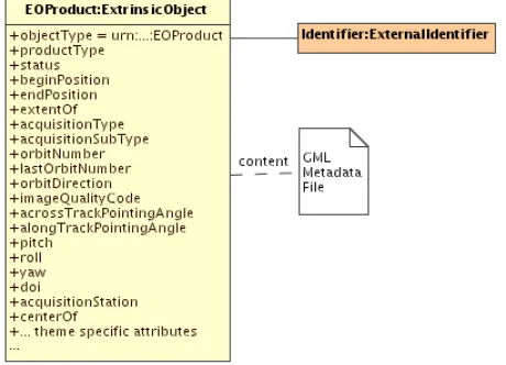
‘urn:ogc:def:objectType:OGC-CSW-ebRIM-EO::EOProduct’ objectType attribute. This ExtrinsicObject is the main object of the EO Product mapping schema. This object contains a set of attributes, matching the queryable metadata coming from the GML document. These attributes characterize directly the product acquisition.
Figure 9: EO Products instance
The GML metadata file is linked to the main ExtrinsicObject as content (this is the related RepositoryItem). This can be done either internally if the Catalogue is also a repository (the GML file is stored in the Catalogue), or externally if the Catalogue is only a registry (the GML file is linked, or generated from available up-to-date metadata). These implementation details are further discussed in Annex D.
All representative acquisition parameters are available (as fields or slots) for extended search. It allows queries like:
- “Give me all EO Product instances intersecting this footprint, measured after this date and acquired with an Accross-Track Pointing Angle less than x degrees”. More formally:
- “Give me all ExtrinsicObjects with the objectType equals to
‘urn:ogc:def:objectType:OGC-CSW-ebRIM-EO::EOProduct’, the extentOf slot value – a geometry – intersecting this box, the beginPosition value – a ISO 8601 date - greater than this date and the alongTrackIncidenceAngle slot value – a double - less than x”.
Using the CS-W ebRIM request, it gives:
<?xml version="1.0" encoding="UTF-8"?> <csw:GetRecords
xmlns:csw="http://www.opengis.net/cat/csw/2.0.2"
Copyright © 2010 Open Geospatial Consortium, Inc.Copyright
© 2010 Open Geospatial Consortium, Inc. 19
xmlns:ogc="http://www.opengis.net/ogc" xmlns:gml="http://www.opengis.net/gml"
xmlns:wrs="http://www.opengis.net/cat/wrs/1.0" xmlns:rim="urn:oasis:names:tc:ebxml-regrep:xsd:rim:3.0" outputSchema="urn:oasis:names:tc:ebxml-regrep:xsd:rim:3.0"
service="CSW" version="2.0.2" resultType="results" startPosition="1" maxRecords="20">
<csw:QuerytypeNames="rim:ExtrinsicObject">
<csw:ElementSetNametypeNames="rim:ExtrinsicObject">full</csw:ElementSetName> <csw:Constraintversion="1.1.0">
<ogc:Filter> <ogc:And>
<!-- This clause means “returned ExtrinsicObjects must represent EOProduct” --> <ogc:PropertyIsEqualTo>
<ogc:PropertyName>/rim:ExtrinsicObject/@objectType</ogc:PropertyName> <ogc:Literal>urn:ogc:def:objectType:OGC-CSW-ebRIM-EO::EOProduct</ogc:Literal> </ogc:PropertyIsEqualTo>
<!-- This clause mean “ExtrinsicObject’s extentOf slot value must intersect with this box” --> <ogc:BBOX>
<ogc:PropertyName> /rim:ExtrinsicObject/rim:Slot[@name=urn:ogc:def:slot:OGC-CSW-ebRIM-EO::multiExtentOf’]/wrs:ValueList/wrs:AnyValue</ogc:PropertyName>
<gml:Envelope>
<gml:lowerCorner>48.86 -124.18</gml:lowerCorner> <gml:upperCorner>51.72 -111.64</gml:upperCorner> </gml:Envelope>
</ogc:BBOX>
<!-- This clause means “ExtrinsicObject’s acquisition beginPosition slot value must be greater than that date” --> <ogc:PropertyIsGreaterThan>
<ogc:PropertyName> /rim:ExtrinsicObject/rim:Slot[@name=urn:ogc:def:slot:OGC-CSW-ebRIM-EO::beginPosition’]/rim:ValueList/rim:Value</ogc:PropertyName>
<ogc:Literal>2006-07-15T00:00:00Z</ogc:Literal> </ogc:PropertyIsGreaterThan>
<!-- This clause means “ExtrinsicObject’s acquisitionAlongTrackIncidenceAngle must be equals to that value” --> <ogc:PropertyIsLessThan>
<ogc:PropertyName> /rim:ExtrinsicObject/rim:Slot[@name=’urn:ogc:def:slot:OGC-CSW-ebRIM-EO::alongTrackIncidenceAngle’]/rim:ValueList/rim:Value
</ogc:PropertyName> <ogc:Literal>15.3</ogc:Literal> </ogc:PropertyIsLessThan> </ogc:And>
</ogc:Filter> </csw:Constraint> </csw:Query> </csw:GetRecords>
Every EO Product instance shall have the general eop fields in common, plus their theme and mission-specific fields. The main ExtrinsicObject enables searches on the EO Products metadata and acquisition parameters.
The following table details the use of predefined attributes and slots, in order to map information coming from the GML metadata file to the ExtrinsicObject representing the EOProduct. Depending on the cardinality, instances of these slots may not be present in a specific EO Product instance. Mandatory slots shall be present. The EO Product identifier is mapped to an ExternalIdentifier linked to this
20 Co
Figure 10: EO Products instance
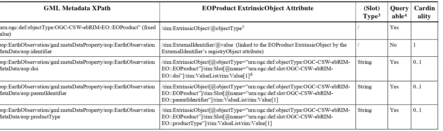
Table 3 — EOProduct ExtrinsicObject Correspondence
GML Metadata XPath EOProduct ExtrinsicObject Attribute (Slot)
Type3
Query able4
Cardin ality
“urn:ogc:def:objectType:OGC-CSW-ebRIM-EO::EOProduct” (fixed value)
/rim:ExtrinsicObject/@objectType5 / Yes
/eop:EarthObservation/gml:metaDataProperty/eop:EarthObservation MetaData/eop:identifier
/rim:ExternalIdentifier/@value (linked to the EOProduct ExtrinsicObject by the ExternalIdentifier’s registryObject attribute)
/ No 1
/eop:EarthObservation/gml:metaDataProperty/eop:EarthObservation MetaData/eop:doi
/rim:ExtrinsicObject[@objectType=”urn:ogc:def:objectType:OGC-CSW-ebRIM- EO::EOProduct”]/rim:Slot[@name=”urn:ogc:def:slot:OGC-CSW-ebRIM-EO::doi”]/rim:ValueList/rim:Value[1]6
String Yes 0..1
/eop:EarthObservation/gml:metaDataProperty/eop:EarthObservation MetaData/eop:parentIdentifier
/rim:ExtrinsicObject[@objectType=”urn:ogc:def:objectType:OGC-CSW-ebRIM- EO::EOProduct”]/rim:Slot[@name=”urn:ogc:def:slot:OGC-CSW-ebRIM-EO::parentIdentifier”]/rim:ValueList/rim:Value[1]
String Yes 0..1
/eop:EarthObservation/gml:metaDataProperty/eop:EarthObservation MetaData/eop:productType
/rim:ExtrinsicObject[@objectType=”urn:ogc:def:objectType:OGC-CSW-ebRIM- EO::EOProduct”]/rim:Slot[@name=”urn:ogc:def:slot:OGC-CSW-ebRIM-EO::productType”]/rim:ValueList/rim:Value[1]
String Yes 0..1
3 For the readability of the table, the slot type corresponds to the data type short name defined in section 8.2.2 (Table 2). In the section 8.2.2, the short name is mapped to the full data type URN. In
the ebRIM model, the full URN must be used.
4 This field defines if a property is queryable. Non-queryable metadata cannot appear in query requests, but they are useful in catalog responses to enhance the presentation. By adding these metadata
to the ebXML response to a query, we avoid that a client would have to interface directly to the repository document to receive the full set metadata – ie. making multiple calls to a) get a query response in ebXML, and then b) fetch a GML document for each result.
5 In this document, the rim prefix is associated to the namespace "urn:oasis:names:tc:ebxml-regrep:xsd:rim:3.0". The wrs prefix is associated to the namespace “http://www.opengis.net/cat/wrs/1.0”.
The notations are not meant to be used literally: in particular, since the ebRIM AP specializes ExtrinsicObject, etc., in the wrs namespace, the above expressions may also be expressed in the wrs namespace.
6 The notation /rim:ExtrinsicObject[@objectType=”urn:ogc:def:objectType:OGC-CSW-ebRIM-EO::EOProduct”]/rim:Slot[@name=”
urn:ogc:def:slot:OGC-CSW-ebRIM-EO::doi”]/rim:ValueList/rim:Value[1] is used to identify the slots in the correct ExtrinsicObject. This notation cannot be used in a GetRecords query (see §0 for a GetRecord query example).
Copyright © 2010 Open Geospatial Consortium, Inc.Copyright
GML Metadata XPath EOProduct ExtrinsicObject Attribute (Slot)
7 Slots “vendorSpecificAttributes” and “vendorSpecificValues” are intimately linked, since the first one contains all values of eop:localAttribute’s elements (ordered) and the second one all values of
eop:localValue’s elements (ordered). So they are either both present or both missing, and they always have the same number of slot values. Value n of the Slot “vendorSpecificValues” is the
localValue corresponding to the localAttribute encoded as the nth value of the Slot “vendorSpecificAttributes”.
8 See section 7.8 (Spatial References) of the doc [OGC 07-110] (ebRIM profile of CSW) to see how to include GML data into ebRIM Slots.
GML Metadata XPath EOProduct ExtrinsicObject Attribute (Slot)
Copyright © 2010 Open Geospatial Consortium, Inc.Copyright
GML Metadata XPath EOProduct ExtrinsicObject Attribute (Slot)
GML Metadata XPath EOProduct ExtrinsicObject Attribute (Slot)
Copyright © 2010 Open Geospatial Consortium, Inc.Copyright
26 Copyright © 2010 Open Geospatial Consortium, Inc.
GML Metadata XPath EOProduct ExtrinsicObject Attribute (Slot)
Copyright © 2010 Open Geospatial Consortium, Inc.Copyright © 2010 O
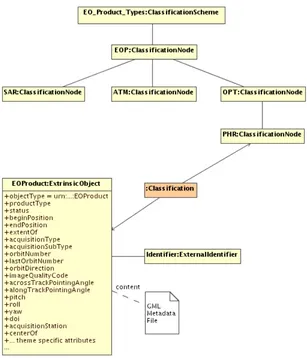
8.2.5 Earth Observation Taxonomy
A taxonomy is needed to distinguish EOProduct types in the ebRIM Catalogue (at the thematic or mission-specific levels). That taxonomy is modeled using a
ClassificationScheme object and a hierarchy of ClassificationNodes:
Figure 11: EO Product Types Taxonomy
Each EO Product shall be classified in the taxonomy. The EO Product ExtrinsicObject
shall be linked to its corresponding ClassificationNode through a Classification
object. This allows EO Products discovery by acquisition type. For example, the following query allows to fetch the EOProducts types
ClassificationScheme in order to retrieve all children or descendants
ClassificationNodes. Classified ExtrinsicObject representing EOProducts can be discovered through Classifications linked to such ClassificationNodes.
Example 1 – GetRecords query, to fetch ClassificationScheme.
<?xml version="1.0" encoding="UTF-8"?> <csw:GetRecords
xmlns:csw="http://www.opengis.net/cat/csw/2.0.2" xmlns:ogc="http://www.opengis.net/ogc"
xmlns:rim="urn:oasis:names:tc:ebxml-regrep:xsd:rim:3.0" outputSchema="urn:oasis:names:tc:ebxml-regrep:xsd:rim:3.0" version="2.0.2"
resultType="results" startPosition="1" maxRecords="20" service=”CSW”>
<csw:QuerytypeNames="rim:ClassificationScheme">
<csw:ElementSetNametypeNames="rim:ClassificationScheme">full</csw:ElementSetName> <csw:Constraintversion="1.1.0">
<ogc:Filter>
<!-- This clause means “Get the EO_Product_Types ClassificationScheme” --> <ogc:PropertyIsEqualTo>
<ogc:PropertyName>/rim:ClassificationScheme/Name/LocalizedString/@value</ogc:PropertyName> <ogc:Literal>EO_Product_Types</ogc:Literal>
</ogc:PropertyIsEqualTo> </ogc:Filter>
</csw:Constraint> </csw:Query> </csw:GetRecords>
28 Copyright © 2010 Open Geospatial Consortium, Inc.
Products instances of type PHR”.
- “Give me all objects linked to the PHR ClassificationNode through a
sed on acquisition type. Such relationship allows queries like: - “Give me all EO
More formally:
Classification”.
Example 2 – GetRecords query ba
<?xml version="1.0" encoding="UTF-8"?> <csw:GetRecords
xmlns:csw="http://www.opengis.net/cat/csw/2.0.2" xmlns:ogc="http://www.opengis.net/ogc"
xmlns:rim="urn:oasis:names:tc:ebxml-regrep:xsd:rim:3.0" outputSchema="urn:oasis:names:tc:ebxml-regrep:xsd:rim:3.0" version="2.0.2"
resultType="results" startPosition="1" maxRecords="20" service=“CSW“>
<csw:QuerytypeNames="rim:ExtrinsicObject rim:Classification rim:ClassificationNode"> <csw:ElementSetNametypeNames="rim:ExtrinsicObject">full</csw:ElementSetName> <csw:Constraintversion="1.1.0">
<ogc:Filter> <ogc:And>
<!-- This clause means “Select the PHR ClassificationNode” --> <ogc:PropertyIsEqualTo>
<ogc:PropertyName>/rim:ClassificationNode/@code</ogc:PropertyName> <ogc:Literal>PHR</ogc:Literal>
</ogc:PropertyIsEqualTo>
<!-- This clause means “Get Classification linked to the PHR ClassificationNode” --> <ogc:PropertyIsEqualTo>
<ogc:PropertyName>/rim:Classification/@classificationNode</ogc:PropertyName> <ogc:PropertyName>/rim:ClassificationNode/@id</ogc:PropertyName> </ogc:PropertyIsEqualTo>
<!-- This clause means “Such Classifications must classify ExtrinsicObject” --> <ogc:PropertyIsEqualTo>
<ogc:PropertyName>/rim:Classification/@classifiedObject</ogc:PropertyName> <ogc:PropertyName>/rim:ExtrinsicObject/@id</ogc:PropertyName>
</ogc:PropertyIsEqualTo>
<!-- This clause means “Classified ExtrinsicObjects must be of type urn:…:EOProduct” --> <ogc:PropertyIsEqualTo>
<ogc:PropertyName>/rim:ExtrinsicObject/@objectType</ogc:PropertyName> <ogc:Literal>urn:ogc:def:objectType:OGC-CSW-ebRIM-EO::EOProduct</ogc:Literal> </ogc:PropertyIsEqualTo>
Copyright © 2010 Open Geospatial Consortium, Inc.Copyright © 2010 O
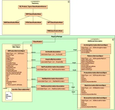
Figure 12: EO Product classified 8.2.6 Platform, Product and Archiving Metadata
Additional information is linked to the main EO Product ExtrinsicObject. These additional metadata are stored into specific ExtrinsicObjects, linked to the main one using Associations. Implementations claiming conformance to this specification shall implement all the associations and slots defined in this section. Depending on the cardinality, instances of the associations or slots may not be present in a specific EO Product instance. Mandatory slots and associations shall be instantiated.
The Acquisition Platform parameters (i.e., Platform, Instrument and Sensor) are stored in an ExtrinsicObject having the objectType attribute set to
‘urn:ogc:def:objectType:OGC-CSW-ebRIM-EO::EOAcquisitionPlatform’. It is linked to the main ExtrinsicObject through an Association object, with the associationType
attribute equals to ‘ urn:ogc:def:associationType:OGC-CSW-ebRIM-EO::AcquiredBy’.
An Acquisition Platform metadata set may be common to multiple acquisitions, defining therefore a n:1 association from the EO Product ExtrinsicObject to the matching EO Acquisition Platform ExtrinsicObject.
30 Copyright © 2010 Open Geospatial Consortium, Inc. Such information ensures EO Products search by acquisition platform, and provides a way to do queries like:
- “Give me all EO Product acquired by this kind of Sensor”
More formally:
- “Give me all ExtrinsicObjects with objectType equals to
‘urn:ogc:def:objectType:OGC-CSW-ebRIM-EO::EOProduct’, which are source of an Association of type
‘urn:ogc:def:associationType:OGC-CSW-ebRIM-EO::AcquiredBy’ pointing – as target – to an ExtrinsicObject having as objectType ‘urn:ogc:def:objectType:OGC-CSW-ebRIM-EO::EOAcquisitionPlatform’ and having this as sensorType slot value”.
In ebRIM, the CS-W request is formulated as :
<?xml version='1.0' encoding='utf-8' ?>
<csw:GetRecords
xmlns:csw="http://www.opengis.net/cat/csw/2.0.2"
xmlns:ogc="http://www.opengis.net/ogc"
xmlns:gml="http://www.opengis.net/gml"
xmlns:rim="urn:oasis:names:tc:ebxml-regrep:xsd:rim:3.0"
outputSchema="urn:oasis:names:tc:ebxml-regrep:xsd:rim:3.0"
service="CSW"
version="2.0.2"
resultType="results"
startPosition="1"
maxRecords="20">
<csw:Query typeNames="rim:ExtrinsicObject rim:ExtrinsicObject_ACQPLAT rim:Association">
<csw:ElementSetName typeNames="rim:ExtrinsicObject">full</csw:ElementSetName>
<csw:Constraint version="1.1.0">
<ogc:Filter>
<ogc:And>
<ogc:PropertyIsEqualTo>
<ogc:PropertyName>/rim:ExtrinsicObject/@objectType</ogc:PropertyName>
<ogc:Literal>urn:ogc:def:objectType:OGC-CSW-ebRIM-EO::EOProduct</ogc:Literal>
</ogc:PropertyIsEqualTo>
<ogc:PropertyName> $ACQPLAT/rim:Slot[@name=”urn:ogc:def:slot:OGC-CSW-ebRIM-EO::sensorType”]/rim:ValueList/rim:Value[1]</ogc:PropertyName>
<ogc:Literal>OPTICAL</ogc:Literal>
</ogc:PropertyIsEqualTo>
<ogc:PropertyIsEqualTo>
<ogc:PropertyName>/rim:Association/@associationType</ogc:PropertyName>
<ogc:Literal>urn:ogc:def:associationType:OGC-CSW-ebRIM-EO::AcquiredBy</ogc:Literal>
</ogc:PropertyIsEqualTo>
Copyright © 2010 Open Geospatial Consortium, Inc.Copyright
© 2010 Open Geospatial Consortium, Inc. 31
<ogc:PropertyName>/rim:Association/@sourceObject</ogc:PropertyName>
<ogc:PropertyName>/rim:ExtrinsicObject/@id</ogc:PropertyName>
</ogc:PropertyIsEqualTo>
<ogc:PropertyIsEqualTo>
<ogc:PropertyName>/rim:Association/@targetObject</ogc:PropertyName>
<ogc:PropertyName>$ACQPLAT/@id</ogc:PropertyName>
</ogc:PropertyIsEqualTo> </ogc:And>
</ogc:Filter>
</csw:Constraint> </csw:Query> </csw:GetRecords>
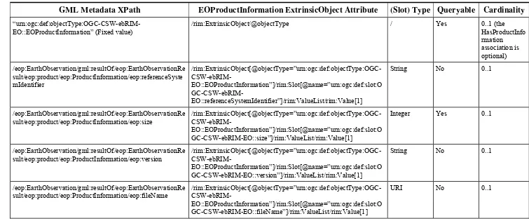
Product Information, associated to the EOProduct, are mapped to ExtrinsicObjects
(with objectType attribute equals to ‘ urn:ogc:def:objectType:OGC-CSW-ebRIM-EO::EOProductInformation’) and linked to the EO Product through Associations
having the associationType attribute equals to ‘ urn:ogc:def:associationType:OGC-CSW-ebRIM-EO::HasProductInformation’.
Browse Information, associated to the EOProduct, are mapped to ExtrinsicObjects
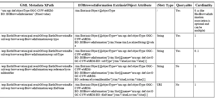
(with objectType attribute equals to ‘ urn:ogc:def:objectType:OGC-CSW-ebRIM-EO::EOBrowseInformation’) and linked to the EO Product through Associations
having the associationType attribute equals to ‘ urn:ogc:def:associationType:OGC-CSW-ebRIM-EO::HasBrowseInformation’.
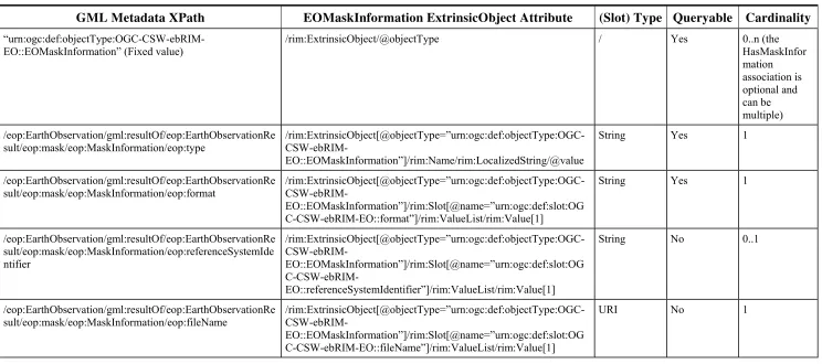
Mask Information, associated to the EOProduct, are mapped to ExtrinsicObjects (with
objectType attribute equals to ‘
urn:ogc:def:objectType:OGC-CSW-ebRIM-EO::EOMaskInformation’) and linked to the EO Product through Associations having the associationType attribute equals to ‘ urn:ogc:def:associationType:OGC-CSW-ebRIM-EO::HasMaskInformation’.
Note that ExtrinsicObjects representing Product Information, Browse Information and Mask Information are mainly intended to provide useful information in the ebXML representation of Earth Observation Products (e.g. the response of a getRecords
Copyright © 2010 Open Geospatial Consortium, Inc.Copyright © 2010 O
Figure 13: EO Products additional information
The following tables define the use of predefined attributes and slots, in order to map information coming from the GML metadata file to these additional ExtrinsicObjects.