OGC 11-039r3
Open Geospatial Consortium
Publication Date: 2014-02-24 Approval Date: 2013-09-25 Submission Date: 2013-08-28 Reference URL for this document:http://www.opengis.net/doc/DP/hy-features
Reference number of this OGC document: OGC 11-039r3 Category: Discussion Paper Editors: Irina Dornblut, Rob Atkinson
OGC HY_Features
:
a Common Hydrologic Feature Model
Copyright notice
Copyright ©2014 Open Geospatial Consortium.
To obtain additional rights of use, visit http://www.opengeospatial.org/legal/.
This document is not an OGC Standard. This document is an OGC Discussion Paper and is therefore not an official position of the OGC membership. It is distributed for review and comment. It is subject to change without notice and may not be referred to as an OGC Standard. Further, an OGC Discussion Paper should not be referenced as required or mandatory technology in procurements
Document type: Discussion Paper Document subtype:
OGC 11-039r3
ii Copyright © 2014 OGC
License Agreement
Permission is hereby granted by the Open Geospatial Consortium, ("Licensor"), free of charge and subject to the terms set forth below, to any person obtaining a copy of this Intellectual Property and any associated documentation, to deal in the Intellectual Property without restriction (except as set forth below), including without limitation the rights to implement, use, copy, modify, merge, publish, distribute, and/or sublicense copies of the Intellectual Property, and to permit persons to whom the Intellectual Property is furnished to do so, provided that all copyright notices on the intellectual property are retained intact and that each person to whom the Intellectual Property is furnished agrees to the terms of this Agreement.
If you modify the Intellectual Property, all copies of the modified Intellectual Property must include, in addition to the above copyright notice, a notice that the Intellectual Property includes modifications that have not been approved or adopted by LICENSOR. THIS LICENSE IS A COPYRIGHT LICENSE ONLY, AND DOES NOT CONVEY ANY RIGHTS UNDER ANY PATENTS THAT MAY BE IN FORCE ANYWHERE IN THE WORLD.
THE INTELLECTUAL PROPERTY IS PROVIDED "AS IS", WITHOUT WARRANTY OF ANY KIND, EXPRESS OR IMPLIED, INCLUDING BUT NOT LIMITED TO THE WARRANTIES OF MERCHANTABILITY, FITNESS FOR A PARTICULAR PURPOSE, AND NONINFRINGEMENT OF THIRD PARTY RIGHTS. THE COPYRIGHT HOLDER OR HOLDERS INCLUDED IN THIS NOTICE DO NOT WARRANT THAT THE FUNCTIONS CONTAINED IN THE INTELLECTUAL PROPERTY WILL MEET YOUR REQUIREMENTS OR THAT THE OPERATION OF THE INTELLECTUAL PROPERTY WILL BE
UNINTERRUPTED OR ERROR FREE. ANY USE OF THE INTELLECTUAL PROPERTY SHALL BE MADE ENTIRELY AT THE USER’S OWN RISK. IN NO EVENT SHALL THE COPYRIGHT HOLDER OR ANY CONTRIBUTOR OF
INTELLECTUAL PROPERTY RIGHTS TO THE INTELLECTUAL PROPERTY BE LIABLE FOR ANY CLAIM, OR ANY DIRECT, SPECIAL, INDIRECT OR CONSEQUENTIAL DAMAGES, OR ANY DAMAGES WHATSOEVER RESULTING FROM ANY ALLEGED INFRINGEMENT OR ANY LOSS OF USE, DATA OR PROFITS, WHETHER IN AN ACTION OF CONTRACT, NEGLIGENCE OR UNDER ANY OTHER LEGAL THEORY, ARISING OUT OF OR IN CONNECTION WITH THE IMPLEMENTATION, USE, COMMERCIALIZATION OR PERFORMANCE OF THIS INTELLECTUAL PROPERTY. This license is effective until terminated. You may terminate it at any time by destroying the Intellectual Property together with all copies in any form. The license will also terminate if you fail to comply with any term or condition of this Agreement. Except as provided in the following sentence, no such termination of this license shall require the termination of any third party end-user sublicense to the Intellectual Property which is in force as of the date of notice of such termination. In addition, should the Intellectual Property, or the operation of the Intellectual Property, infringe, or in LICENSOR’s sole opinion be likely to infringe, any patent, copyright, trademark or other right of a third party, you agree that LICENSOR, in its sole discretion, may terminate this license without any compensation or liability to you, your licensees or any other party. You agree upon termination of any kind to destroy or cause to be destroyed the Intellectual Property together with all copies in any form, whether held by you or by any third party.
Except as contained in this notice, the name of LICENSOR or of any other holder of a copyright in all or part of the Intellectual Property shall not be used in advertising or otherwise to promote the sale, use or other dealings in this Intellectual Property without prior written authorization of LICENSOR or such copyright holder. LICENSOR is and shall at all times be the sole entity that may authorize you or any third party to use certification marks, trademarks or other special designations to indicate compliance with any LICENSOR standards or specifications.
OGC 11-039r3
Copyright © 2014 OGC iii
Contents
Foreword ... vii
Introduction ... viii
1. Scope ... viii
2. Conformance ... ix
3. Normative references ... ix
4. Terms and definitions ... x
5. Conventions ... xii
5.1 Symbols (and abbreviated terms) ... xii
5.2 UML notation ... xiii
6. HY_Features: A Common Hydrologic Feature Model ... 1
6.1 Scope of the hydrologic feature model ... 1
6.1.1 HY_Features in the overall context of OGC standards ... 1
6.1.2 HY_Features in the overall context of the WMO Information System ... 3
6.1.3 Properties of hydrologic features and its observation ... 4
6.2 General requirements for a Common Hydrologic Feature Model ... 6
6.2.1 General Applicability ... 6
6.2.2 Stability of Identifiers ... 7
6.2.3 Scale-independence ... 7
6.2.4 Governance ... 7
6.2.5 Implementation Neutrality ... 8
6.3 The Hydrology phenomenon and its abstract notion ... 8
6.3.1 The Hydrology Phenomenon ... 8
6.3.2 The abstract notion: Catchment and Basin ... 10
6.3.3 Multiple representations of catchment in the real world ... 11
7. HY_Features, conceptual model ... 13
7.1 Basic concept ... 14
7.2 Organization of the UML model ... 15
7.3 HY_Utilities ... 16
7.4 HY_HydroFeature ... 17
OGC 11-039r3
iv Copyright © 2014 OGC
7.6 HY_SurfaceHydroFeature ... 28
7.7 HY_SubsurfaceHydroFeature ... 29
7.8 HY_HydrometricNetwork ... 31
8. Discussion ... 32
8.1 Compatibility of concepts ... 32
8.1.1 Basin vs. DrainageBasin as of INSPIRE ... 33
8.1.2 Outfall vs. Contracted Node as of AHGF ... 34
8.1.3 IndirectPosition vs. NetworkPosition as of ISO19133 ... 35
8.1.4 HydrometricFeature vs. WaterMonitoringPoint as of WaterML2 ... 35
8.1.5 RiverML (under development) ... 35
8.1.6 GroundwaterML (under development) ... 36
8.1.7 Outfall vs. Pour point of ArcHydro GIS ... 36
8.2 Hydrologic referencing and linked data ... 36
9. Further work ... 38
9.1 XML Encoding ... 38
9.2 OWL encoding ... 38
9.3 Validation ... 39
10. References ... 40
Figures
Figure 1 HY_Features in the context of the OGC Abstract Specifications ... 2Figure 2 Placement of HY_Features in the context of WIS / WIGOS ... 4
Figure 3 Processes of the Hydrologic Cycle ... 10
Figure 4 Many network nodes mapped to single logical node ... 11
Figure 5 Cartographic representation vs. topology ... 12
Figure 6 Alternative cartographic representations of a catchment / basin ... 12
Figure 7 Cartographic and grid cell connectivity representation of streamlines ... 13
Figure 8 HY_Features – Package dependencies ... 16
Figure 9 HY_Utilities – Package dependencies ... 17
OGC 11-039r3
Copyright © 2014 OGC v
Figure 11 UML diagram: Catchment and Basin ... 19
Figure 12 UML class diagram: Catchment and CatchmentRepresentation ... 20
Figure 13 UML class diagram: Basin,Outfall, IndirectPosition ... 21
Figure 14 UML class diagram: ReferencePoint and associated phenomena ... 22
Figure 15 UML class diagram: HY_HydrographicNetwork ... 23
Figure 16 UML class diagram: HY_HydroFeature ... 24
Figure 17 UML class diagram: HY_RiverPositioningSystem ... 25
Figure 18 UML class diagram: HY_Storage ... 26
Figure 19 UML: HY_AtmosphericFeature – Package dependencies ... 27
Figure 20 UML class diagram: HY_Precipitation ... 28
Figure 21 HY_SurfaceHydroFeature – Package dependencies ... 28
Figure 22 UML class diagram: SurfaceWaterConfines ... 29
Figure 23 HY_SubsurfaceHydroFeature – Package dependencies ... 30
Figure 24 UML class diagram: SubsurfaceWaterConfines ... 31
Figure 25 HY_HydrometricNetwork – Package dependencies ... 32
Figure 26 INSPIRE Hydrography, v3.0.1 [13]– HydroObject ... 33
Figure 27 AHGF Hydrological Reporting Catchment ... 34
OGC 11-039r3
vi Copyright © 2014 OGC
i.
Abstract
Common semantics support the reference of features to the concept they represent and the integration of data proceed using the semantic framework such mappings provide. However there is no standard conceptual model for hydrologic feature identification. Different models of hydrologic processes, and different scales of detail, lead to a variety of information models to describe these features, and to different and mostly
incompatible sets of feature identifiers.
This document describes requirements and a proposed design for a domain model of hydrologic features as a set of interrelated Application Schemas using the ISO 19109 General Feature Model,
ii.
Keywords
hydrology; feature; feature identification; common; semantic; reference model; information model; data integration; linked data; application schema; WMO
iii.
Preface
Attention is drawn to the possibility that some of the elements of this document may be the subject of patent rights. The Open Geospatial Consortium shall not be held
responsible for identifying any or all such patent rights.
Recipients of this document are requested to submit, with their comments, notification of any relevant patent claims or other intellectual property rights of which they may be aware that might be infringed by any implementation of the standard set forth in this document, and to provide supporting documentation.
iv.
Submitting organizations
The following organizations submitted this Document to the Open Geospatial Consortium
a) CSIRO (Australia)
OGC 11-039r3
Copyright © 2014 OGC vii
v.
Document contributor contact points
All questions regarding this document should be directed to the editor or the contributors:
Contact Company Address Phone Email
Rob Atkinson CSIRO .. +61 419202973 Rob.atkinson<at>csiro.au Irina Dornblut GRDC .. +49 261 16035265 dornblut<at>bafg.de
vi.
Changes to the OpenGIS
→
→
Specification
This document required no changes to the OpenGIS ® Abstract Specification.
Concerns are raised regarding governance of utility classes that are not specific to this domain, but not currently available in the OGC and ISO model baseline.
Foreword
This is an OGC Discussion Document. This document is not an OGC Standard.
Suggested additions, changes, and comments on this report are welcome and encouraged. Such suggestions may be submitted by OGC portal message, email message, or by making suggested changes in an edited copy of this document.
Attention is drawn to the possibility that some of the elements of this document may be the subject of patent rights. The Open Geospatial Consortium Inc. shall not be held responsible for identifying any or all such patent rights.
OGC 11-039r3
viii Copyright © 2014 OGC
Introduction
The WMO is the UN system's authoritative voice on the state and behavior of the Earth's atmosphere, its interaction with the oceans, the climate it produces and the resulting distribution of water resources. It facilitates the free and unrestricted exchange of data, products and services and contributes to policy formulation at national and international levels.
The WMO promotes the utilization of international industry standards for transfer protocols, hardware and software enabling the routine data collection and automated dissemination of observed data as well as ad-hoc requests for data and products. Being a recognized international standardization body, WMO has the mandate to set standards in these areas.
The water related activities of the WMO are shaped by the Commission for Hydrology (WMO-CHy). This includes advice on the standardization of various aspects of
hydrologic observations, as well as on the sharing and exchanging of hydrologic data using modern information and communication technology.
The need for a domain-specific feature model emerges from the requirement to integrate data and information across multiple systems, emerging from the global geographic distribution of jurisdiction over water resources and the multiple systems and
sub-domains that concern or interact with the hydrology domain. To communicate compatible data and information about a distinct state of a hydrologic process, to integrate multiple or cross-reference alternative representations of a hydrologic feature, it becomes
necessary to identify the concepts shared in different application contexts and to express the semantics of hydrologic features commonly used in disparate and differently
structured data products.
1.
Scope
This is an OGC Discussion Paper for review by OGC members and other interested parties. It is a working draft document and may be updated, replaced by other documents at any time. It is inappropriate to use OGC Discussion Papers as reference material or to cite them as other than “work in progress.”
This document was produced as part of the joint WMO/OGC Hydrology Domain Working Group activity. It is intended to become a candidate for a WMO Best Practice
for implementation under the auspices of the WMO-CHy and release to the hydrologic community of WMO Member countries.
OGC 11-039r3
Copyright © 2014 OGC ix
Schemas using ISO 19103 Conceptual Schema Language and ISO 19109 General Feature Model. It is factored into relatively simple components that can be reviewed, tested and extended independently.
2.
Conformance
The standardization (conformance) target of the HY_Features model is a related
application schema for a data product describing hydrologic features. Such an application schema may be either the direct encoding of HY_Features or another schema formally mapped to HY_Features equivalent classes and properties. The conceptual model
addresses the general requirements to integrate hydrologic data and information available across the scientific and technical programs of the WMO, to assist the WMO Members to discover, access und use hydrologic data from different sources.
However, the conceptual model raises a series of opportunities and requirements for testing in the context of many application domains related to hydrologic processes. Appropriate conformance requirements need to be defined in respect to the use of the model to support hydrologic referencing and system interoperability of information services and in data infrastructures.
Conformance to the HY_Features model requires that an implementation is able to:
a) map the feature type of each implemented GF_Feature to the equivalent concept in HY_Features, wherever such an instance of such a feature may be referenced as a hydrologic feature
b) map all properties of the implemented feature to the equivalent property expressed by feature properties within the HY_Features model where such a mapping exists
The precise mechanism for such a mapping is not defined at this stage.
3.
Normative references
The following normative documents contain provisions which, through reference in this text, constitute requirements of this document. For dated references, subsequent
amendments to, or revisions of, any of these publications do not apply. For undated references, the latest edition of the normative document referred to applies.
ISO 19101:2002, Geographic Information—Reference Model
OGC 11-039r3
x Copyright © 2014 OGC
ISO 19107:2003, Geographic Information — Spatial schema
ISO 19108:2006, Geographic Information — Temporal schema
ISO 19109:2006, Geographic Information — Rules for application schemas
ISO 19115:2012, Geographic Information — Metadata – Fundamentals (Draft)
4.
Terms and definitions
For the purposes of this document, the following terms and definitions apply.
The HY_Features model uses as far as possible the terminology recommended for use in the WMO Member countries and represented by the “UNESCO/WMO International Glossary of Hydrology” [1].Whenever an appropriate definition is provided in this glossary, the model captures this meaning and relationships to define relevant features and feature properties.
4.1 application schema
conceptual schema for data required by one or more applications [ISO 19101].
NOTE: In general, a schema is an abstract representation of an object's characteristics and relationship to other objects. An XML schema represents the relationship between the attributes and elements of an XML object (for example, a document or a portion of a document)
4.2 basin
hydrologic unit wherein all incoming water is channeled to a common outlet.
NOTE: The common outlet of a basin may be a particular location, but also a body of water. It may be a real place or a fictive one built from joining several places.
4.3 catchment
distinct unit catching something, e.g. water.
NOTE: Across scientific disciplines in the domain of hydrology, a catchment is commonly recognized as the basic unit of study and reporting. .
4.4 domain feature
feature of a type defined within a particular application domain. [ISO19156]
4.5 feature
abstraction of real-world phenomena [ISO19101]
4.6 hydrographic network
OGC 11-039r3
Copyright © 2014 OGC xi
4.7 hydrography
science dealing with the description and measurement of open bodies of water. [WMO1992]
NOTE: In this context, hydrography refers to the description of water bodies. Its measurement in terms of surveying, e.g. for navigational purposes, is not in the concern of the HY-Features model.
4.8 hydrologic feature
abstract notion of the hydrology phenomenon.
4.9 hydrology
science that deals with the waters above and below the land surfaces of the Earth, their occurrence, circulation and distribution, both in time and space, their biological, chemical and physical properties, their reaction with their environment, including their relation to living beings.
[WMO1992]
4.10 hydrometric feature
real-world phenomenon which forms part of a hydrometric network.
NOTE: The hydrometric feature refers to a physical structure intended to observe properties of a hydrologic feature. Used to sample a hydrologic feature, a hydrometric feature may be considered a sampling feature of observation. A sampling feature is described in general in ISO 19156, the special monitoring point of hydrologic observation is described in the WaterML 2.0 Specification.
4.11 hydrometry
science of the measurement and analysis of water including methods, techniques and instrumentation used in hydrology.
[WMO1992]
4.12 mapping
mapping of elements of disparate representations of a hydrologic feature.
NOTE: In the context of common semantics, it refers to concept mapping particularly to an agreed reference concept.
4.13 multilingual keyword
keyword used in a multilingual context.
NOTE: A keyword is generally described in ISO 19115.
4.14 named feature
feature identified by a name.
NOTE: Hydrologic features and their real-world representations have names within common experience, but may have different names in their cultural, political and historical contexts.
4.15 observable property
OGC 11-039r3
xii Copyright © 2014 OGC
NOTE: The observable property may be indirect, relying on direct observation of a more convenient parameter [observed property], which is a proxy for the ultimate [observable] property of interest.
4.16 representation
real-world phenomenon representing an abstract feature.
4.17 river positioning system
linear system used to reference indirect positions along a watercourse.
NOTE: The concept of indirect position describes a location on the land surface relative to or as a distance to a reference point located in a hydrographic network on a hydrographic feature applying a linear coordinate system. Position may be described relative to the reference point as distance , percentage of this, , or expressed verbally.
4.18 sampling feature
artifacts of an observational strategy … intended to sample some feature of interest in an application domain.
[ISO 19156]
4.19 storage
impounding of water in surface or underground reservoirs, for future use. [WMO1992]
NOTE: Storage refers to a water body in terms of a usable water resource. The management of the reservoir as human action with the objective to efficient and sustainable use the resource, is not in the scope of the HY_Features model. Yet, often an indication is required whether a water body is used for storage.
4.20 variable
characteristic carried by a real-world phenomenon liable to change.
NOTE: Values expressing the change are usually obtained by observing the variable. A variable may take any value in a range of possible values.
NOTE: A variable may be a quantity having a magnitude, additive or non-additive, or multitude whose values can be expressed by a number, but also a nominal property expressed using words, alpha-numeric codes, or Boolean values.
4.21 water body
mass of water distinct from other masses of water is considered a water body. [WMO1992]
NOTE: A water body represents a hydrologic feature in the real world. A water body may be segmented in single parts which are real-world phenomena itself.
5.
Conventions
OGC 11-039r3
Copyright © 2014 OGC xiii
CHy WMO Commission for Hydrology
GML Geography Markup Language
GRDC Global Runoff Data Centre
HDWG OGC Hydrology Domain Working Group
ISO International Organization for Standardization
OGC Open Geospatial Consortium
OWL Web Ontology Language
UML Unified Modeling Language
WaterML 2 WaterML 2.0 – an observations model for hydrology
WIS WMO Information System
WIGOS WMO Integrated Global Observing System
WMO World Meteorological Organization
XML eXtensible Markup Language
5.2 UML notation
OGC 11-039r3
Copyright © 2014 OGC 1
6.
HY_Features
: A Common Hydrologic Feature Model
6.1 Scope of the hydrologic feature model
The HY_Features model defines the semantics of features which are the overall objects of study and reporting in hydrology and its associated scientific disciplines. It provides a means to identify these features independent from scale of geographic representation. It also enables multiple representations of these (real-world) features, with alternative data models, to be linked to the ultimate object of study or reporting.
The initial scope of this model is defined by the concerns of the WMO-CHy to facilitate the data sharing within the hydrologic community of the WMO Member countries and to improve the quality of data products based in these data. Interoperability of observing systems needs standardized formats and transfer routines, such as WaterML 2, however the compatibility of data products also requires agreed concepts to describe the features of shared interest. In the hydrology domain these features represent results of the
hydrologic processes at various stages of the water cycle, relevant to study and report the “waters above and below the land surfaces of the Earth, their occurrence, circulation and distribution, both in time and space, their biological, chemical and physical properties, and their reaction with their environment”[1]. This scope includes well-established data models and patterns in use in the hydrology domain, since the intended goal is to support these using a common conceptual model.
The HY_Features model is intended to sufficiently describe hydrologic features
referenced in the various data sets in current use and to form a basis for a common and stable referencing of these features to assist the organization of their observation and modeling as well as the aggregation of generated data into integrated suites of datasets on a global, regional, or basin scale.
The model encompasses different approaches of modeling hydrologic features, but enforces the semantics of relationships between different levels of detail. This provides a semantic framework for feature identifiers to be developed and embedded in individual data products without constraining the flexibility required to model complex
hydrological processes at fine detail.
6.1.1 HY_Features in the overall context of OGC standards
OGC 11-039r3
2 Copyright © 2014 OGC
this is expected to provide a model for use in applications of WaterML 2.0
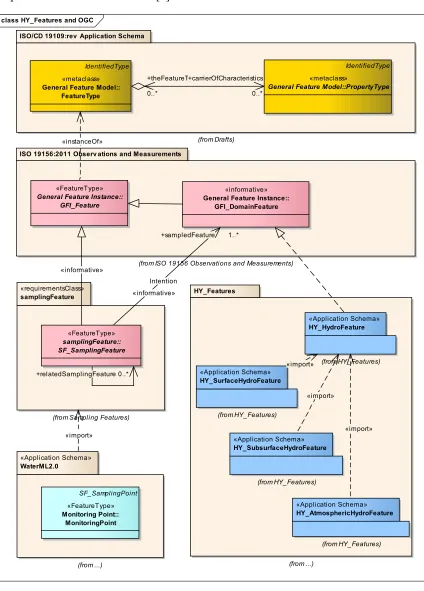
Implementation Profile of O&M.[3] class HY_Features and OGC
ISO/CD 19109:rev Application Schema
(from Drafts)
ISO 19156:2011 Observ ations and Measurements
(from ISO 19156 Observations and Measurements)
«requirementsClass»
General Featurenstance: GF_Feature
+relatedSamplingFeatur0..
Intention
OGC 11-039r3
Copyright © 2014 OGC 3
Figure 1shows how the HY_Features model might fit into the existing OGC feature landscape. For applications in hydrology, particularly in the context of hydrologic observation and sampling, the proposed HY_HydroFeature will represent the ultimate subject of observation, the intended sampled DomainFeature and may be used by observation-centric applications such as WaterML2.
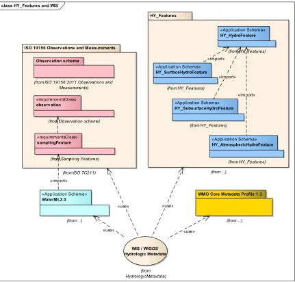
6.1.2 HY_Features in the overall context of the WMO Information System WIS, the WMO Information System, provides mechanisms for the international exchange of information related to weather, climate and water. In this framework, the
WMO Core Metadata Profile version 1.3 [4] was developed. This specification defines the content, structure and encoding of discovery metadata published within the WIS Discovery-Access-Retrieval (DAR) Catalogue. The metadata standard defined as an informal category-1 profile of the ISO 19115:2003 ‘Geographic information – Metadata’
WIGOS, the WMO Integrated Global Observing System, is a coordinated system which is comprised of the present WMO global observing systems. Complementary to the WMO Core Metadata Profile, a WIGOS Core Metadata Standard is under development that allows the essential observational information to be exchanged unambiguously, regardless of the format used for the transfer.
In this context, the HY_Features model will provide a required component of a metadata model describing hydrologic data sets and products generated from observation. Other controlled vocabularies will be required, and a binding mechanism to specify how these independently governed and published components can be combined.
OGC 11-039r3
4 Copyright © 2014 OGC
class HY_Features and WIS
WMO Core Metadata Profile 1.3
(from ...) ISO 19156 Observ ations and Measurements
(from ISO TC211)
(from ISO 19156:2011 Observations and Measurements)
Figure 2 Placement of HY_Features in the context of WIS / WIGOS
6.1.3 Properties of hydrologic features and its observation
Hydrologic objects (real-world phenomena) have characteristic properties that change according to continuous hydrologic processes. Values expressing this change are usually obtained by observing a Variable related to these characteristics. Such a Variable may have different roles in different contexts: observable property, observed property,
OGC 11-039r3
Copyright © 2014 OGC 5
O&M defines observation as “an act that results in the estimation of a feature property” [2], thus in principle each such Variable shall be an instance of the general PropertyType
(aka GF_PropertyType) metaclass. The determination of what such a named property may be called or mean is bound to observation processes themselves, and the variety of these cannot be determined in advance, Thus, observable characteristics are not generally in the scope of the HY_Features model. The relation between the hydrologic feature and its observable variables needs to be specified at the application level. HY_Features
OGC 11-039r3
6 Copyright © 2014 OGC
6.2 General requirements for a Common Hydrologic Feature Model
Hydrologic processes are constrained by and interact with the landscape and the medium in which they occur. These interactions are complex and variable through time. It is common practice to identify and refer to specific instances of a hydrologic feature when describing the state of any of these hydrologic processes or associated human activities. Persistent landscape features such as catchment, basin, watershed or water body are classic examples of concepts, common in many fields of discourse, but yet different according to the focus on various aspects of the hydrology phenomenon.
Hydrologic processes commonly are studied and reported in logical units related to the behavior of water. Depending on application and scale these units are multiple
represented in the real world by a variety of phenomena, either single objects or a composite or network of these. The reference to the shared unit of study by different applications may be challenging if different semantics and identifiers are used for different delineations. Stable and persistent identifiers are required to reflect hydrologic significance and topological connectivity of features across disparate representations and different scales.
A re-usable core of generally applicable concepts, capable of being partially realized in existing implementations, may increase the acceptance of the model in the addressed community. The required governance by an accepted, internationally acting authority, like the WMO, will be supported by a canonical form, implementation neutrality and conformity to internationally recognized standards.
6.2.1 General Applicability
To be generally applicable to a wide range of applications where hydrologic feature identification needs to be persisted or shared, feature characterizations given in different systems must be supported without specifying what characteristics may be assigned in a specific context. Instead of being a comprehensive set of all, or commonly used
characteristics, a re-usable core model is required that supports application specific specializations. For example, an application concerned with rainfall runoff could extend the model to include soil moisture and land cover parameters that are not necessary to define the unit of study itself. A representation such as a remote-sensed grid field can be added for any parameter, as could a simple attribute for a characteristic value. Numerical model starting conditions and parameters may be provided on the basis of
characterization of e.g. basin features, and model outputs may be reported at basin scale or combined into a single result on the basis of the hydrologic connectivity of basins.
OGC 11-039r3
Copyright © 2014 OGC 7
6.2.2 Stability of Identifiers
Stability of identifiers means that factors that change the representation of a feature in an information system, should not change the identifier of the feature itself. Such factors may be the improved resolution or accuracy of representation, minor changes to physical characteristics of the feature that occur over time, but also changes of technology
platform, implementation or custodian. It is a core requirement of general applicability (6.2.1) to support stability of identifiers across different representations to allow multiple systems to use, or map to, these identifiers.
With regard to hydrology, identifiers must be able to stably reflect the hydrologic significance of a feature regarding both its contributing catchment and its topological connectivity to upstream and downstream features. Those features that can be given stable identifiers in this context must be distinguished from those that are defined within the context of a specific representation. For example, a DEM derived drainage network will have many predicted flow lines, but these may be simply a function of the resolution of the DEM, and not reflect physical reality. Key features such as major confluences may be represented, often due to drainage enforcement from vector representations, but nevertheless identifiable features.
6.2.3 Scale-independence
Hydrologic features exist at any scale, from a continental scale river basin to the basin upstream of any point in a detailed river network. Whether observing, modeling or reporting, the choice of the scale made by the user depends on the special purpose of its study. Some scales seems to be more or less general because of their wide range of use, but always chosen for a specific purpose, e.g. for mapping or comparative reporting, they are still distinct.
Scaling up or down leads to multiple representations of the same hydrologic feature. A common model must support simplifications at small scales and details at large scales allowing hydrologic feature complexes to be potentially encapsulated within simpler features at a less detailed scale. The co-existence of multiple hierarchical aggregations of features into alternative networks needs to be supported.
The requirement for identifier stability (6.2.2) implies that the same features must be identifiable where present in different scales of mapping. Reporting on a coarse scale needs to be supported as well as aggregating features at finer levels of detail in a consistent fashion to generate information at coarser scales.
6.2.4 Governance
OGC 11-039r3
8 Copyright © 2014 OGC
To be accepted as a Best Practice by the WMO-CHy, a common model shall not
contradict existing positions of the WMO. This implies two other requirements. The first and most important is conformity, where applicable, to existing definitions defined and endorsed by the WMO–CHy. The key reference here is the UNESCO/WMO
International Glossary of Hydrology [1]. The second implication is that the model has no dependencies on aspects not recognized by the WMO within its standardization agenda. This is addressed by the plan to submit the model to the WMO-CHy for implementation into WIS and WIGOS, upon satisfactory results of testing.
6.2.5 Implementation Neutrality
Intended to be released to a community of sovereign WMO Member countries, no national data standard or proprietary technology for implementation should be directly referenced. Furthermore, existing standard implementations, industry or open, and implementations that are approved within the WMO standardization context are preferred. Implementation neutrality, i.e. no recommendation of a specific
implementation or, particular technology, is fundamental to import new components in existing implementations.
The use of ISO 19103 Conceptual Schema Language and Application Schema modeling idiom [7] is commonly expected as well as the provision of XML schema definitions of the individual model components.
6.3 The Hydrology phenomenon and its abstract notion
6.3.1 The Hydrology Phenomenon
Hydrology is the science dealing with waters above, on and below the land surfaces of the Earth, their occurrence, circulation and distribution in time and space, their
biological, chemical and physical properties, and their reaction with the environment [1]. This definition applies to water in all of its phases moving from the atmosphere to the Earth and back to the atmosphere due to the processes forming the Water Cycle.
The processes governing the continuous depletion and replenishment of water resources result at various stages in a wide range of hydrologic objects which are subject to
monitoring, modeling and reporting in hydrology. Water from precipitation reaching the land surface is accumulated in water bodies occupying empty space on the land surface or in water bearing formations of soil and rock. Due to continuous interaction with soil water and groundwater, a water body permanently gains or loses water.
OGC 11-039r3
Copyright © 2014 OGC 9
Water bodies may be aggregated into a hydrographic network using a connecting system of channels expressed in flow or drainage patterns. This system of channels exists independently of whether water flows therein or not. It does not define whether a water body interacts with water bodies upstream and downstream. For example, normally stagnant waters may or may not be connected to streams during flood events, or streams may be interrupted to pools of stagnant water in periods of drought or not. Likewise, an aquifer system determines the potential connection between bodies of groundwater, but not causes the interaction.
Water may be stored and managed in surface or underground reservoirs in terms of a resource for future use, for regulation and control. Conceptually, each water body, or the layers therein, may be managed as a reservoir. Referring to the mass of water usually managed in particular layers, storage reservoirs are typically considered as stratified water bodies. Also due to differences in thermal or salinity characteristics, or by oxygen or nutrient content a water body may be stratified vertically into distinct layers.
Water bodies have individual names within common usage, but these may be variant in different cultural, political or historical contexts. In international programs and projects geographic names are usually fixed by convention.
Water bodies are observed using monitoring stations and observing posts. Almost all stations are physical artifacts, or collections of these. Yet, some stations may be fictive ones. Monitoring stations may be connected logically in hydrometric networks which usually represent a distinct unit of monitoring or reporting at local or regional scale. It is common practice to locate a monitoring station with respect to local landmarks and permanent reference points, or in relation to the extent of the monitored water body.
Water and water bodies are studied and reported in hydrologic „water“ units shared across disciplines and domains at national or international levels. Examples are the so-called “River Basin Districts” of the European Water Framework Directive [8]
OGC 11-039r3
10 Copyright © 2014 OGC
Figure 3 Processes of the Hydrologic Cycle
6.3.2 The abstract notion: Catchment and Basin
It is common practice in today’s environmental reporting to report the hydrologic
processes and their results in a holistic approach at catchment scale. The catchment is the abstract notion of the hydrology phenomenon (Figure 3) commonly recognized across hydrologic disciplines and cross-domain. It is the shared unit of study usually addressed in inter-disciplinary programs, inter-program collaboration and cross-domain research projects, and also the management unit agreed across administrative jurisdictions and the unit of joint monitoring and reporting.
A special type of catchment is the hydrologically determined basin. The term “basin” is used inconsistently in the literature, sometimes to denote an entire river system,
sometimes a sub-basin or an inter-basin between key features such as major confluences in the river system. In terms of conformity to the WMO endorsed semantics, a definition is applied which refers to the physiographic unit wherein all incoming water is channeled to a common outlet.
OGC 11-039r3
Copyright © 2014 OGC 11
aggregated to a point located at the mouth (Figure 4). The geometric representation varies with the application: it may be a point but also a curve or a surface.
Figure 4 Many network nodes mapped to single logical node
Basins are organized in hierarchies and related topologically in networks. They may be aggregated to complete river basins or to intermediate hydrologically discrete upper-level systems like management units. For example, generally recognized river basins are often partitioned in discrete sub-basins within a larger basin, with different approaches to aggregating up the lower level of hydrological detail. In terms of network connectivity, a basin gets inflow from a contributing upstream basin and flows out into a receiving basin downstream.
Catchments and basins have inherent characteristics induced from interactions with other domains assigned in spatial, temporal or classification contexts. Almost all of these are indicators of cross-domain applicability for example the geological region wherein the basin is situated, the shared space in an encompassing WMO Region, or a temporary reporting region.
6.3.3 Multiple representations of catchment in the real world
Depending on application and scale, the same catchment may be displayed in different ways. Reporting and analysis of landscape interactions refers typically to areas of study or its boundaries. A basin may be described geometrically e.g. by the bounding
watershed, drainage area or streamlines, or topologically as a graph of nodes and links, a reporting region as member of a regional hierarchy. Some applications require
OGC 11-039r3
12 Copyright © 2014 OGC
(Figure 5).
Figure 5 Cartographic representation vs. topology
Cartographic representations without topology can still be partitioned using the boundary on the river-system scale, forcing a simple relationship between a trivial topology and the spatial representation of these coarse features (Figure 6).
Figure 6 Alternative cartographic representations of a catchment / basin
OGC 11-039r3
Copyright © 2014 OGC 13
errors. Sometimes features may not be topologically connected, but represent the best available representation, another time the segmentation of features carries no semantic content in terms of representation or naming.
Figure 7 Cartographic and grid cell connectivity representation of streamlines
7.
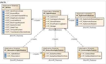
HY_Features
, conceptual model
The HY_Features model describes the major components of the hydrosphere and their fundamental relationships according to the semantics expressed in definitions endorsed by the WMO. It provides referencable concepts that may be addressed by applications reflecting a wide range of hydrologic features in different scientific disciplines in the hydrology domain and cross-domain.
OGC 11-039r3
14 Copyright © 2014 OGC
The conceptual model is expressed in the ISO 19103 Geographic Information Conceptual Schema Language [7] and ISO 19109 General Feature Model as a set of Application Schemas containing Feature Type definitions[11]). It is based on a broad industry standard, the Unified Modeling Language (UML) [12].
The model is developed in a multi-step process whereby the requirements for hydrologic referencing is reconciled with typical data set designs and semantics endorsed by the WMO-CHy. Module identification aims to simplify the scope of each part of the model in order to improve its accessibility and provide scope for testing. It is intended that each implemented data product needs to consider only those parts of the common model implicated by its scope. This is facilitated and made transparent by using only those modules that define concepts referenced by the data set.
Differences in terminology may be explored through reconciling accepted definitions endorsed by the WMO-CHy and represented by the “UNESCO/WMO International Glossary of Hydrology” (IGH) [1], with the different aspects reflected in various data sets and products. It is intended to apply, wherever appropriate, the terms from the IGH to the identified semantic constructs. This has the effect of augmenting the accepted definitions with explicit semantics for the relationships with other terminology.
7.1 Basic concept
A hydrologic feature is the abstract notion of the hydrology phenomenon. The core concept of HY_Features is that a study of the hydrology phenomenon will reflect common concepts of the real world by specific modeled features (as per ISO 19109 General Feature Model). Depending on the scientific concern, the relevant hydrologic feature may represent different aspects of the hydrology phenomenon.
Commonly recognized as the abstract unit of study and reporting in the hydrology domain, a catchment is considered as a hydrologic feature. Each catchment may be represented in any hydrologically meaningful sub-domain model, including by a simple tree network of „blue lines“, or the nested network of catchments. A catchment is multiple represented in the real world by a variety of hydrologic phenomena which are monitored, modeled and reported in typical applications. Catchment area, catchment boundary, flowpath, hydrographic network, channel network, or hydrometric network are alternative views representing a catchment.
OGC 11-039r3
Copyright © 2014 OGC 15
Each basin may be nested in a containing basin in a simple “is-part-of” hierarchy as typically used for high order organization of management and reporting units. Each basin may be sub-basin of an all-encompassing basin, either as tributary basin without an identified inflow, or as inter-basin determined by inflow and outflow.
By definition, the common outlet of a basin has no explicit location and no explicit geometry. A basin may be represented geometrically by an area (e.g. drainage area), a boundary polygon (e.g. watershed), or a curve (e.g. flowpath, or an indicative straight line). Since the geometry will vary with application, it needs to be defined there.
7.2 Organization of the UML model
The HY_Features model is a set of inter-related modules containing definitions for key aspects of hydrologic systems. The model is managed in sub-domain specific packages, allowing extension to the core set and involvement of relevant expert groups in the governance of individual models.
The HY_ prefix follows the ISO naming conventions for UML elements. There is no explicit requirement that these names to be used in implementing systems for the same semantic elements. It is not yet specified how mappings between abstract element names and implementations should be recorded. Nevertheless it is expected that future
interoperability will be facilitated by making such mappings available as a component of dataset documentation.
NOTE: The HY-prefix refers to the Greek “hydro” and means water in general because of “waters above and below the land surfaces of the Earth” (WMO 2010) is the principal object of study in hydrology.
NOTE: The EXT-prefix refers to “external”, common patterns that are required, but not hydrology-specific, and should be imported when available from an external source.
HY_Features model comprises the following packages:
HY_Utilities, containing utility classes for common patterns required by the domain model that are not hydrology-specific;
HY_HydroFeature, incl. HY_Catchment, HY_HydrographicNetwork, HY_NamedFeature, HY_RiverPositioningSystem and HY_Storage;
HY_AtmosphericFeature;
HY_SubsurfaceHydroFeature, incl. HY_SubsurfaceWater and
HY_SubsurfaceWaterConfines;
HY_SurfaceHydroFeature, incl. HY_SurfaceWater and HY_SurfaceWaterConfines;
HY_HydrometricNetwork.
OGC 11-039r3
16 Copyright © 2014 OGC
Figure 8 HY_Features – Package dependencies
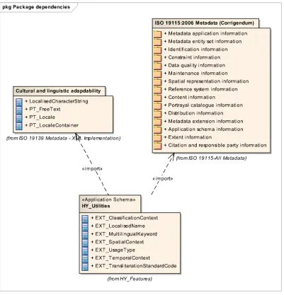
7.3 HY_Utilities
HY_Utilities package (Figure 9) contains utility classes for common patterns expected to be important for cross-domain harmonization. They should be provided in an external library for cross-domain usage. It is expected that future evolution of the ISO standards will provide a replacement for these components. At that point this package can be replaced with references to this library.
These classes provide:
Cross-cultural name support (EXT_LocalisedName,
EXT_MultilingualKeyword, EXT_TransliterationStandardCode, EXT_UsageType)
OGC 11-039r3
Copyright © 2014 OGC 17
Figure 9 HY_Utilities – Package dependencies
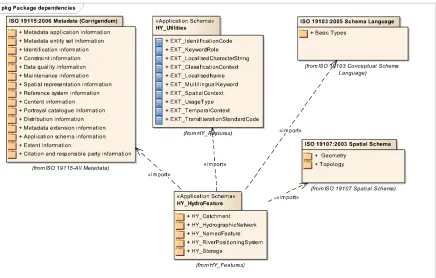
7.4 HY_HydroFeature
HY_HydroFeature schema (Figure 10) defines the fundamental properties and
OGC 11-039r3
18 Copyright © 2014 OGC
Figure 10 HY_HydroFeature – Package dependencies
HY_Catchment package defines a logical network of catchments. The catchment model is sufficient for the case of simplified hierarchies of catchments, particularly basins, without unnecessary detail of varying flow conditions and cartographic interpretation. It allows for the existence of basins to be recognized and identifiers assigned based on outflow nodes, even if stream networks, watershed boundaries and areas are not reliably determined. It is intended that hydrological reporting applications may use this model without the full complexity of the HY_Features model.
OGC 11-039r3
Copyright © 2014 OGC 19
class basinHierarchy
HY_HdroFeature
«FeatureTyp... HY_Catchment::
HY_Catchment
«FeatureType» HY_Catchment::HY asin «FeatureType»
HY_Catchment:: HY asinAggregate
+suasin 1
+encompassiasin 1
+upstreamasin
1
+containingCatchme
Figure 11 UML diagram: Catchment and Basin
HY_Catchment defines the most common concepts of catchment representation including the formation of soil or rock with hydrologically significant characteristics
(hydrogeologic unit). This allows the catchment concept to be referenced from a wide range of applications. If required, subtypes may be defined at the application level.
OGC 11-039r3
20 Copyright © 2014 OGC
class catchmentRepresentation
HY_HdroFeature «FeatureType»
HY_Catchment::HY_Catchment
«FeatureType»
HY_Catchment:: HY_CatchmentArea
«FeatureType»
HY_Catchment:: HY_CatchmentBoundary
«FeatureType» HYatchment::
HY_CatchmentRepresentation
«FeatureTyp...
HY_Catchment:: HY_FloPath
«FeatureTyp... _Catchment::
HY_Ntor k
«FeatureType» _SubsurfaceWaterConfines::
HY_HydroGeologicUnit
+representedCatchment 1
Figure 12 UML class diagram: Catchment and CatchmentRepresentation
OGC 11-039r3
Figure 13 UML class diagram: Basin,Outfall, IndirectPosition
Fixed by coordinates (related to the land surface via datum), the ReferencePoint itself is outfall of a corresponding basin in the network of basins. Defining typical reference points, such as fixedLandmark, crossSectionPoint, or extractionPoint, particular real-world phenomena may be associated to the basin they represent. The concept allows for the topological relationship between hydrometric stations to be established based on the
positionOnRiver without detail of hydrography, hydraulic conditions, and cartographic interpretation.
OGC 11-039r3
HY_Subsurf,'-/aterConfines::
HY2/ell
Figure 14 UML class diagram: ReferencePoint and associated phenomena
HY_HydrographicNetwork package provides for the topological relationships to be declared between the major elements of the hydrosphere, including the segmentation of the hydrographic network into water bodies without imposing a particular network scale (Figure 15). It is defined in the context of a higher order identification of the network each element participates, hence the dependency on the abstract catchment model.
HY_HydrographicNetwork introduces concepts of WaterBody and WaterBodySegments
which may or may not be topologically connected at the representational level, as well as of the vertical partition into cross or longitudinal sections and the horizontal stratification into distinct layers. Liquid water (Water_LiquidPhase) may be accumulated in water bodies, ice (Water_SolidPhase) may be accumulated in glaciers, or cover a water body.
Glacier is introduced here to provide a means to take the multiple relationships between glacier and water body into account at the application level. As glaciology is a science for its own, the relationships between glacier and water body are not in the scope of the
OGC 11-039r3
Figure 15 UML class diagram: HY_HydrographicNetwork
OGC 11-039r3
24 Copyright © 2014 OGC
cljllmames and identifiers
sxTz{|}alise~ame
ataType» HY_Hydroeaturmame
+ namesart ool. false HY_HydratureContet
+name
+hydroFeature
..1
+context
Figure 16 UML class diagram: HY_HydroFeature
These named features are further elucidated in concrete feature types which specify the properties each representation uses to define one or more aspects of the hydrology of a feature. This includes related phenomena that participate in hydrologic systems but have specific characteristics. Given the complexity of the domain, and the nature of real world physical phenomena, for any given feature a wide range of possible characteristics, states and representations may be relevant.
HY_RiverPositioningSystem (Figure 17) package provides a means to reference positions on a hydrographic feature via its topology and geometry. The package introduces the concept of IndirectPosition where each location on the land surface may be described relative to, or as a distance to, a reference point located in the hydrographic network. The distance to the reference point is provided as Length, the relative position described as a percentage of the distance or using terms common in the hydrology domain such as “upstream”, “downstream”, “nearby”, etc..
IndirectPosition requires a river mileage system whose origin is set at the position of the relevant point of interest, e.g. a water monitoring point, in the network. The coordinates are provided as distance upstream or downstream from this origin to the identified reference point. Since river mileage systems usually refer to a line (such as thalweg or stream centre line) assuming a horizontal curve, the river mileage system may use the one-dimensional CS_LinearCS of ISO 19111:Referencing by coordinates [4] .
OGC 11-039r3
Copyright © 2014 OGC 25
class hl_riv erPositioningSystem
«FeatureType» HY²±ileageSystem³´µs
+ directi ¡ ¢£¤¥elativ¦§ositi ¨escripti © ª¬.®
+ precisi ¡ ¨istanc¦© ª¬.®
«C¶¦·¸st»
HY_Riv erPositioningSystem:: HY_Relativ ePosition¹escriºtion
+ at HY²¹istanÂÃÄoRefPoint
+ accuracyStatement¡ScÁ¦¶Åam¦© ª¬.®
Figure 17 UML class diagram: HY_RiverPositioningSystem
This concept supports basins to be related topologically and allows the hydrosphere to be divided into a network of basins (links between outfalls). Considering an arbitrary
hydrometric station as Outfall of a basin, it may be located depending on its
positionOnRiver without having local coordinates.
HY_Storage (Figure 18) package provides an abstract pattern to describe a particular water body capable to store and yield water in terms of a resource for future use. This allows surface and subsurface reservoirs to be described independent of their
OGC 11-039r3
Figure 18 UML class diagram: HY_Storage
7.5 HY_AtmosphericHydroFeature
This application schema (Figure 19) defines concepts of the hydrology phenomenon above the Earth’s land surface without the complexity of a rainfall-runoff model.
With respect to the hydrologic cycle, hydrometeors consisting of liquid or solid water particles falling through or suspended in the atmosphere are in the scope of the
HY_Features model. Since water from precipitation is the main source of freshwater accumulated in water bodies, Hydrometeor is specialized into Precipitation consisting of liquid and solid water particles. Further specialization of is left to specific applications, as well as special concepts of water suspended in the atmosphere.
OGC 11-039r3
Copyright © 2014 OGC 27
Figure 19 UML: HY_AtmosphericFeature – Package dependencies
class hlá_atmoâáheriãäeature
«FeatureType»
HY_åtmosæçèricHydréêèature::
HY_Preciæitation «FeatureType»
HY_åtmosæçèricHydréêèature::
HY_Hydréëeteor
«FeatureType»
HY_Hydrograæçìcíetîorï::
HYðñaterðòióuidPhase
«FeatureType»
HY_Hydrograæçìcíetîorï::
HYð ñater_SolidPhase +snowmelt ô..1
+iceFraction ô..1
OGC 11-039r3
28 Copyright © 2014 OGC
Figure 20 UML class diagram: HY_Precipitation
7.6 HY_SurfaceHydroFeature
This application schema (Figure 21) defines concepts of the hydrology phenomenon on the Earth’s land surface with respect to water bodies aggregated in a hydrographic network using a connecting system of confining channels, but without complexity and detail of hydrologic and hydraulic models.
Figure 21 HY_SurfaceHydroFeature – Package dependencies
SurfaceWater (informative package) summarizes the most popular water bodies (mass of water) on the land surface each special by the property to permanently or temporarily move, by origin, by extent, by the phase of the contained water, or by their interaction with open sea. Depending on the implementation, each special type of hydrographic feature may be described by suitable attributes.
OGC 11-039r3
HY_Surfùú ûüaterConfines::HY_ChannelNet orý
+ drainattern HY_rain attern0.1]
Figure 22 UML class diagram: SurfaceWaterConfines
The SurfaceHydroFeature modelallows to separately address the water body and the connecting watercourse, or parts of these. It is intended that applications in surface water hydrology, modeling hydraulics and morphology of streams use this model to reference the represented hydrologic feature.
7.7 HY_SubsurfaceHydroFeature
This application schema (Figure 23) defines concepts of the hydrology phenomenon below the Earth’s land surface in respect to water accumulated in water bodies below the Earth's surface incl. their interaction with surface water bodies without the
OGC 11-039r3
30 Copyright © 2014 OGC
Figure 23 HY_SubsurfaceHydroFeature – Package dependencies
SubsurfaceWater (informative package) summarizes the most popular types of liquid water occupying empty space in soil and aquifers. Depending on the implementation, the special types of subsurface water in the saturated and unsaturated zone may be described by suitable attributes. As hydrogeology is a science on its own, the special relationships between groundwater and a water body are not in the scope of HY_Features model. To take into account the effects of groundwater interaction on a gaining/losing water body (-segment), Groundwater may be associated with the relevant water body at the
application level.
OGC 11-039r3
Copyright © 2014 OGC 31
class hl _su surfaceHydro eature
HYaterqdhase
Figure 24 UML class diagram: SubsurfaceWaterConfines
The SubsurfaceHydroFeature modelallows to separately address types of subsurface water as well as the containing aquifer without details of accumulation and movement of water. It is intended that applications dealing with groundwater and soil moisture may use this to reference the represented hydrologic feature.
7.8 HY_HydrometricNetwork
NOTE: Not to be confused with the natural network of hydrographic features.
NOTE: Not to be confused with network sampling as distinct method of sampling.
This application schema (Figure 25) defines a hydrometric network as an aggregate of hydrometric features which are logically connected, for example along a hydrographic feature. Hydrometric features may be physical artifacts, or a collection of these. Yet, some hydrometric features may be fictive ones. They may have localized names, typical properties and individual characteristics. In the observation context, the
HydrometricFeature represents a sampling feature.
OGC 11-039r3
32 Copyright © 2014 OGC
mandatory positioned in relation to a reference point fixed by coordinates.
Figure 25 HY_HydrometricNetwork – Package dependencies
The HydrometricNetwork model allows to address a hydrometric network as a whole but also individual parts of this. Applications capturing the monitoring of hydrologic
features, the observation and measurement of their properties may use this model to locate a WaterMonitoringPoint (as of WaterML2) [2] on the sampled hydrologic feature, as well as to reference the logic network of (fictive) hydrometric features representing the ultimate hydrologic feature like a catchment or basin. This is often required in the context of processing primary data, observed using real-world stations, into a new set of secondary data obtained using stations related to these.
8.
Discussion
8.1 Compatibility of concepts
OGC 11-039r3
Copyright © 2014 OGC 33
The HY_Features model is intended to form the basis for standard practices for feature identification under the auspices of the WMO Commission for Hydrology (WMO-CHy). To achieve this goal, compatibility to similar concepts must be supported. HY_Features
provides generally applicable concepts for reference, to which application-specific concepts may refer either by specialization or by mapping.
8.1.1 Basin vs. DrainageBasin as of INSPIRE
The INSPIRE (Infrastructure for Spatial Information in the European Community) Directive addresses the Hydrology issues in the data specification “D2.8.I.8: INSPIRE Data Specification on Hydrography“ v.3.0.1 [8] as the basic reference for use within the INSPIRE context. This specification defines an abstract HydroObject covering all
Physical Waters including the relation between DrainageBasin and SurfaceWaters
(Figure 26). DrainageBasin has 1..* outlets which are SurfaceWaters, and may contain sub-basins.
Figure 26 INSPIRE Hydrography, v3.0.1 [13]– HydroObject
NOTE: SurfaceWaters refers to any physical body of water.
NOTE: DrainageBasin refers to the area having a common outlet for its surface runoff.
This definition corresponds to the definition of BasinAggregate (in HY_Features), rather than Basin which is defined as a link between single inflow and outflow nodes.
OGC 11-039r3
34 Copyright © 2014 OGC
subBasins each of them identified by an Outfall whose location may be a surface water body.
8.1.2 Outfall vs. Contracted Node as of AHGF
Australian Hydrological Geofabric (AHGF) [13] identifies important water features in the landscape as well as the connections between these features. Identifying persistent
ContractedNodes that are points of hydrological significance that carry identity, the AHGF supports multiple representations of water features. Such a contracted node may be the Outfalls of a basin as defined in the HY_Features model.
The concepts of Catchment, BasinAggregate, Basin and Outfall of the HY_Features
model have been implemented within the Geofabric as “HR_Catchments” (in terms of
Catchment), as “Contracted Catchments” (in terms of BasinAggregate) and “AHGF Node” (in terms of Outfall). “Link” (in terms of Basin as a link) represents the topological connection between the catchment hierarchy.
Figure 27 AHGF Hydrological Reporting Catchment