Learner Guide
Cambridge IGCSE
®
Cambridge International Examinations retains the copyright on all its publications. Registered Centres are permitted to copy material from this booklet for their own internal use. However, we cannot give permission to Centres to photocopy any material that is acknowledged to a third party even for internal use within a Centre.
® IGCSE is the registered trademark of Cambridge International Examinations.
© Cambridge International Examinations 2015
Contents
How to use this guide
... 3
Section 1: How will you be tested? Section 2: Examination advice Section 3: What will be tested? Section 4: What you need to know Section 5: Useful websites
Section 6: Command words and phrases
Section 1:
How will you be tested? ... 5
About the examinations About the theory papers About the practical papers
Section 2:
Examination advice ... 9
General advice Paper 1 advice Paper 2 advice Paper 4 advice
Section 3:
What will be tested? ... 13
Section 4:
What you need to know ... 15
How to use the table
Theme 1: Population and settlement Theme 2: The natural environment Theme 3: Economic development
Section 5:
Useful websites ... 29
How to use this guide
How to use this guide
The guide describes what you need to know about your Cambridge IGCSE®
Geography examination.
It will help you to plan your revision programme and will explain what we are looking for.
Not all the information will be relevant to you. You will have to select what you need to cover in Sections 1 and 3 by i nding out from your teacher whether you are doing Paper 3 Coursework or Paper 4 Alternative to Coursework.
The guide contains the following sections:
Section 1: How will you be tested?
This section gives you information about the different examination papers you will take.
Section 2: Examination advice
This section gives you advice to help you do as well as you can. Some of the ideas are general advice and some are based on the common mistakes that learners make in exams.
Section 3: What will be tested?
This section describes the areas of knowledge, understanding and skills that we will test you on.
Section 4: What you need to know
This shows the syllabus content so that you can check:
• which topics you need to know about
• details about each topic area in the syllabus
• how much of the syllabus you have covered.
Section 5: Useful websites
Section 1: How will you be tested?
Section 1: How will you be tested?
About the examinations
You will take three papers: two theory papers, i.e. Paper 1 and Paper 2, and one practical paper, either Paper 3 (Coursework) or Paper 4 (Alternative to Coursework).
Your teacher will be able to tell you whether you are doing coursework (Paper 3) or taking Paper 4.
If you are doing coursework, you will complete one assignment and just take Paper 1 and Paper 2 in the examination. However, if you are not doing coursework, you will take three papers in the examination, i.e. Paper 1, Paper 2 and Paper 4.
About the theory papers
The table below gives you information about the theory papers.
Paper number
How long and how many marks?
What’s in the paper? What’s the % of
the total marks?
Paper 1 1 hour 45 minutes (75 marks)
You must answer three questions from six, one from each theme. There are two questions on each theme.
45%
Paper 2 1 hour 30 minutes (60 marks)
The questions test your skills in interpreting and understanding geographical information including maps. You must answer all the questions.
27.5%
Here is some more detail about each of the theory papers:
Paper 1
You have to answer three of the six questions available, one from each section, so that you answer one question on each of the three themes, so take your time to choose your questions carefully at the start of the examination. Each question will be based on one or more resources, which may be a photograph, a map, a sketch map, diagrams, graphs, written information or tables of data. You will be asked to analyse and use the resource/s to show your understanding of geographical ideas. It will not matter that the examples/ places used in the questions are not familiar to you, but it is important that you know and understand geographical ideas so that you can apply them to any situation. You will often need to illustrate your answer to one part of each question by referring to a relevant case study you have learnt. This paper will be in a question and answer booklet with spaces to write your answers.
Paper 2
Section 1: How will you be tested?
About the practical papers
The remaining papers for Cambridge IGCSE Geography test your understanding and skills in a more practical way. They cover your knowledge of all three themes and test the skills you need to investigate geographical ideas. Your teacher will be able to tell you whether you will be entering for coursework, Paper 3 (one assignment written in your own time) or the alternative to coursework, Paper 4, which tests the same skills and knowledge as Paper 3 in a timed written examination.
Paper number and type
How long and how many marks?
What’s involved? What’s the % of
the total marks?
Paper 3 Coursework
No i xed time (60 marks)
You will complete one coursework
assignment of 2000 words. You may carry out part of the investigation and collect data as a class, BUT you must then write up the investigation on your own.
27.5% (you do
either Paper 3 or
Paper 4)
Paper 4 Alternative to Coursework
1 hour 30 minutes (60 marks)
You will answer two questions, each based on a theoretical investigation, which test how you would carry out i eldwork. The questions will cover data collection methods, presenting data, analysing patterns in data and writing a conclusion.
27.5% (you do
either Paper 3 or
Paper 4)
Here is some more detail about the practical papers:
Paper 3 Coursework
You will carry out one assignment during your geography course, which will be assessed by your teacher. Your teacher will give you marks in i ve different skill areas. Each skill area is marked out of 12 marks. The teacher will look for certain indicators to assess your work.
Skill 1: Knowledge with understanding
You will be assessed on how well you understand the geographical ideas of the investigation. You need to describe the aims of the investigation and try to explain them using geographical terms. Your teacher may suggest that you devise a hypothesis, which you then try to investigate.
Skill 2: Observation and data collection
You will be marked according to how well you carried out your data collection during the investigation, e.g. whether you followed your teacher’s instructions carefully and with thought. You must also show some ideas of your own about data collection and observation, which go beyond those your teacher told you about.
Skill 3: Organisation and presentation of the results
You will also be marked on how you choose to organise and present your data, e.g. put it into graphs or display it on maps. Better presentations generally use the more varied and complicated presentation techniques. However, you should remember that the methods must be relevant and appropriate, e.g. a bar graph may be a better technique than a line graph to compare the results of trafi c surveys carried out at different places.
Skill 4: Analysis and interpretation
Section 1: How will you be tested?
at Site X because this was the centre of the town’. If you were then to explain why the centre of the town attracted more trafi c, you would be applying your geographical understanding and would be able to access the full range of marks for this skill area.
Skill 5: Conclusions and evaluation
In the i nal section you will be assessed on how well you are able to conclude the investigation. Did you prove your hypothesis? What data or evidence did you i nd to support your concluding decisions? You will also be marked on how you criticise and evaluate your data collection methods. You should outline the problems you encountered when collecting the data and suggest better ways of collecting the information for a future investigation.
Paper 4 Alternative to Coursework
In this written paper you will be given the outline of two theoretical investigations. Each investigation will be based on a different theme. Data collection methods which will be used in the investigations are questionnaires, observation, measuring and counts.
You may be asked to:
• formulate aims or hypotheses
• outline how data may be collected during an investigation
• plot data or complete graphs of data
• describe the patterns in the statistics or graphs provided
• explain the meaning of the graphs using your geographical understanding
• write a conclusion to a theoretical investigation
• evaluate the data collection methods used in the investigation
Section 2: Examination advice
Section 2: Examination advice
General advice
Preparing to get a good grade begins as soon as you start your Cambridge IGCSE course. You can prepare by:
• i nding out what you need to know
• organising your notes; making a list of the topics covered and relevant case studies
• knowing how your Cambridge IGCSE papers are structured and practising past questions.
Your notes
• Read the rest of this guide carefully. Be really clear what topics you need to know then check that your notes are complete and make sense. If you need further advice, speak to your teacher who will have a full copy of the syllabus.
• Although there is a choice of questions on Paper 1, Paper 2 and Paper 4 have compulsory questions so you cannot have gaps in your notes just in case those topics come up.
• Try to produce an accurate set of notes when you do the work in the i rst place, but if you need to improve your notes you could:
– Ask a friend if you can copy up work which you have missed from them – but make sure you understand it.
– Find more information on topics you have studied, using your textbook, the library or the internet. For it to be useful make sure that you fully understand it – if not ask your teacher.
– Buy a good revision guide.
Revision
There are lots of different ways to revise. Some people make lists, other people use diagrams and pictures. Once you know what topics to cover, you have to work out the best way to learn them.
• Make a revision timetable and plan your revision carefully so that you have time to i t in everything you need to cover.
• Work in short concentrated spells and then have a break rather than trying to work continuously. Avoid being interrupted – don’t answer the phone/read your text messages/have a look at the TV – save it for your planned break.
Do not sit looking at your notes, or just copy them out. Try to do something active, for example you could:
• draw diagrams and sketch maps, including detailed labels, highlighting the most important points using colours
• draw tables and charts to learn key ideas about the topic such as causes and effects, problems and benei ts and impacts on people and the natural environment which you need to learn
• draw time lines and living graphs that help you pick out how things change and explain the reasons for the changes
Section 2: Examination advice
• use colours or highlighter pens to classify items in your notes e.g. causes/effects, long/short term effects, effects on natural environment/people etc, practise map skills using a variety of different maps – ask your teacher if you can borrow maps which have been used in previous examinations
• ask your teacher for past papers and test yourself. Study as many past papers as possible. This is not the time for you to predict questions but to i nd out what sort of questions come up and what they require you to do. Sometimes it is useful to practise writing out the answers under test conditions
• if your teacher hasn’t explained to you how the exams are marked, ask about it. Ask if you can see questions and their mark schemes from previous examinations. Look particularly at those answers which are worth a lot of marks to discover how you can earn more marks by giving details and examples.
Answer the questions
• Make sure you use your time carefully. For example in Paper 1 there are 75 marks available in
105 minutes, that is just under 1½ minutes per mark, but remember that includes time spent reading, thinking, choosing and planning as well as writing. It is no good writing a page if the question is only worth two marks; an answer worth two marks should take no more than 3 minutes to write. If you spend too long on questions which are not worth many marks it could mean you do not have enough time to answer the questions which are worth seven marks properly. If you do i nish with time to spare, re-read and check your answers adding more facts and ideas if you can remember them.
• Read the questions carefully. When you answer questions on the paper think very carefully. Try to learn how to respond to command words like IDENTIFY, DESCRIBE, EXPLAIN and COMPARE. It is important that you answer the questions and do not fall into the trap of just writing down everything you know.
• Answer the questions in order of how coni dent you are – leave the one you are least coni dent about until last.
• Do not repeat the same answer in different sections. Questions are not set which require identical answers, if you i nd you are repeating an answer check that you have read the question properly.
Paper 1 advice
• Look at the instructions on the front of the paper. You have to choose three out of the six questions, one out of two questions in each section so that you answer a question on each of the three themes.
• Do not try to answer all the questions, you will not have time to answer them properly.
• Write the answers to the questions in the spaces in the question and answer booklet provided, using this as a rough guide to the amount of detail and length of answer that is needed. If you run out of space continue the answer on the spare lined sheet at the back of the booklet. Make sure you number any continuation answers carefully and also indicate that your answer is continued on the extra page at the end of your partly-written answer.
• Look at the number of marks available for each part of a question. Do not spend too much time on one part if it is only worth one or two marks, or alternatively write only a short answer when a question is worth more marks. Timing is important, do not spend too much time on your i rst chosen question, otherwise you will have to rush the last question. Just in case you run out of time, if there is a question which you are not coni dent on, answer it last.
• Read the information given in the stem of the question carefully as well as the questions themselves.
Section 2: Examination advice
• Where you are asked to complete an answer by labelling or drawing on a resource you must do this rather than writing an answer. If you use any extra sheets make sure that you put your name on them and attach them to your answer booklet before handing it in.
• When you are asked to use a written resource you will not be given marks for copying out sections from it. Look at the question you are being asked and try to show your understanding by answering in your own words.
• If you are asked to compare or describe the differences between two things it is no good just writing about one. You could use words like ‘bigger’ or ‘more’ to help you compare or a word like ‘whereas’ in the middle of your sentence (e.g. ‘a constructive wave deposits material on the coast whereas a destructive wave erodes material from it’).
• Try to be as precise as possible as vague statements are unlikely to get you many marks. e.g. ‘A Stevenson Screen is used to get accurate readings’ is far too vague. You need to give details explaining why readings are accurate when a Stevenson Screen is used (the louvres allow a free l ow of air, the white surface rel ects the sun’s rays, it allows you to take temperatures in the shade etc).
• Make sure you know the differences between global environmental problems which you may have studied. Many people mix up global warming, ozone depletion and acid rain. You must also make sure you do not mix up causes and effects/consequences – you may be asked for one or the other so read the question carefully.
Paper 2 advice
• This paper is testing a range of skills. Try to be as accurate as you can with measuring and plotting. Take your time, take care and always use a ruler to complete graphs and measure straight line distances.
• Many questions ask you to ‘use the evidence’ in the resources provided such as the maps, photographs and graphs. You must make sure that you do so rather than using your background knowledge. (e.g. if you are asked to describe the features of an industry shown in a photograph there is no need to include general information about that industry and its location. If you are asked to describe features of a coastal area shown on a map there will be no credit for explaining how they were formed. If you are asked to use evidence from the map to explain why there are no settlements in some areas there is no point in referring to the climate as the map extract is unlikely to include information about it).
• Practise basic map skills, for example six-i gure grid references. Candidates sometimes get the third and sixth i gures confused. Make sure you give the reference for the position of the symbol rather than the name of the place.
• If you are asked to measure a distance it is worth using the linear scale below the map and a straight edged piece of paper. By doing this you will be less likely to make mistakes which are possible when using calculation to convert centimetres to kilometres and metres. Look carefully at what units you need to use, whether you should answer to the nearest kilometre or in metres. Make sure you always give the units in your answer rather than just writing down the number.
• You could be asked to give a direction or a compass bearing. Make sure you know the difference and check which of the features you are measuring from and to, by looking carefully at the wording of the question.
• If you are asked to draw a graph be as accurate as you can, measuring carefully and using a ruler. Take care to draw the type of graph that the question asks for rather than a different type of graph.
Section 2: Examination advice
Paper 4 advice
• This paper is an alternative to coursework and to prepare for it you need to be able to answer questions about collecting, presenting and analysing data like you would in a geographical investigation. There is nearly always a question that asks you to write a conclusion and an evaluation. You need to practise these skills.
• Many of these questions are based on a hypothesis. Make sure you are familiar with testing hypotheses.
• You will be given resources to use in the examination which you have not seen before, perhaps different types of graphs or diagrams. Look at the diagrams carefully and think carefully about what they are showing before you answer the questions. You may be asked to complete a diagram, in which case you need to complete it accurately and carefully.
• You will have to answer questions about data which has already been collected as part of an
investigation. This could be a set of i gures, graphs or maps. One of the things you will be asked to do is to recognise and describe patterns or trends (e.g. the distribution of rainfall over an area as shown on a map or over time as shown on a graph, the amount of erosion alongside a footpath as shown on a diagram). You should practise this skill, using data which you have collected yourself, or data from your teacher.
• If you are asked questions about the data in the resources you will be expected to use that data rather than simply listing or repeating the i gures (e.g. you may be asked to compare two sets of data about different places, look for a relationship between two or more sets of data or recognise similarities and differences). However it is always useful to support your answer by referring back to the resource and quoting data from it.
• Learn about the different types of samples that can be used when collecting data – you may be asked to describe the advantages of using systematic or stratii ed sampling for example. Many candidates assume that the only sample that can be taken is a random sample.
• You may be asked to suggest practical ways in which something could be improved. This could be an actual investigation or something which has been investigated (e.g. the amount and distribution of pollution in a river). You will be expected to be realistic in your suggestions so always think about whether they are practical. For example to suggest that all the residents of a town should be interviewed rather than taking a sample is unrealistic. Similarly, to suggest that all factories alongside the river are shut down is not a suggestion which is practical.
Section 3: What will be tested?
Section 3: What will be tested?
We take account of the following skill areas in your examination papers:
• your knowledge (what you remember) and understanding (how you use what you know and apply it to new situations)
• how you interpret and analyse information, e.g. data, graphs, diagrams, photographs
• how you make judgements and decisions, including conclusions, based on information.
These skills are called assessment objectives. They are explained in the table below. Your teacher will be able to give you more information about how each of these is tested in the examination papers.
Assessment objective
What the objective means
What you need to be able to do
AO1: Knowledge with understanding
Remembering facts and applying these facts to new situations
Demonstrate knowledge and understanding of:
• the wide range of processes, including human actions, contributing to the development of
(a) physical, economic and social environments and their effects on the landscape
(b) spatial patterns and interactions which are important within these environments
• the relationships between human activity and the environment
• the importance of scale (whether local, regional or global)
• the changes which occur through time in places, landscapes and spatial distribution.
AO2: Skills and analysis
How you select information and apply geographical understanding to explain the information
• interpret and analyse geographical data
• use and apply geographical knowledge and
understanding to maps and in numerical, diagrammatic, pictorial, photographic and graphical form
• use geographical data to recognise patterns in such data and to deduce relationships
• select and show understanding of techniques for observing and collecting data
Section 3: What will be tested?
AO3: Judgement and decision-making
Being able to make judgements based on information and recognise possible decisions
Use your geographical training to:
• reason and make judgements and decisions, including evaluation and conclusions, which demonstrate, where appropriate
(a) an appreciation of the attitudes, values and beliefs of others in issues which have a geographical dimension
(b) an awareness of the contrasting opportunities and constraints of people living in different places and under different physical and human conditions
(c) a willingness to review their own attitudes in the light of the views of others and new knowledge acquired
• make judgements and decisions and recognise how these are made within a geographical context as affected and constrained by
(a) the physical and human contexts in which decisions are made
(b) the values and perceptions of differing groups or individuals
(c) the choices available to decision makers
Section 4: What you need to know
Section 4: What you need to know
The table describes the things you may be tested on in the examination. It is arranged in three themes with several topic areas within each theme. Each topic is divided up into sections, which contain the detail that you need to know.
How to use the table
You can use the following table throughout your course to check the topic areas you have covered. You can also use it as a revision aid. When you think you have a good knowledge of a topic, you can tick the appropriate box in the checklist column.
Test yourself as follows:
• cover up the details with a piece of paper
• try to remember the details
• when you have remembered the details correctly, put a tick in the appropriate box.
If you use a pencil to tick the boxes, you can retest yourself whenever you want by simply rubbing out the ticks. If you are using the table as a checklist of which topics you have covered, you can put a tick in the topic column next to the appropriate bullet point.
The column headed ‘Comments’ can be used:
• to add further information about the details for each bullet point
• to add learning aids, e.g. CASH (for corrosion, attrition, solution, hydraulic action)
Section 4:
What y
ou need to kno
w 1 6 C a mbrid g e I G C S E G e o g raph y 0 4 6 0 Section 4: What y
ou need to kno
w
Theme 1: Population and settlement
Topic: You should be able to: Further guidance: Checklist Comments or named case study examples
1.1 Population dynamics
• Describe and give reasons for the rapid increase in the world’s population
• Show an understanding of over-population and under-over-population
Causes and consequences of over-population and under-over-population
• Understand the main causes of a change in population size
How birth rate, death rate and
migration contribute to the population of a country increasing or declining • Give reasons for contrasting rates
of natural population change
Impacts of social, economic and other factors (including government policies, HIV/AIDS) on birth and death rates
• Describe and evaluate population policies
Case studies required in 1.1
• A country which is over-populated
• A country which is under-populated
• A country with a high rate of natural population growth
• A country with a low rate of population growth (or population decline)
1.2 Migration • Explain and give reasons for population migration
Internal movements such as rural-urban migration, as well as international migrations, both voluntary and involuntary • Demonstrate an understanding of
the impacts of migration
Section 4: What y C a mbrid g e I G C S E G e o g raph Section 4: What y
Theme 1: Population and settlement
Topic: You should be able to: Further guidance: Checklist Comments or named case study examples
1.3 Population structure
• Identify and give reasons for and implications of different types of population structure
Age/sex pyramids of countries at different levels of economic development
Case study required in 1.3
• A country with a high dependent population
1.4 Population density and distribution
• Describe the factors inl uencing the density and distribution of population
Physical, economic, social and political factors
Case studies required in 1.4
• A densely populated country or area (at any scale from local to regional)
• A sparsely populated country or area (at any scale from local to regional)
1.5 Settlements and service provision
• Explain the patterns of settlement Dispersed, linear, and nucleated settlement patterns
• Describe and explain the factors which may inl uence the sites, growth and functions of settlements
Inl uence of physical factors (including relief, soil, water supply) and other factors (including accessibility, resources)
• Give reasons for the hierarchy of settlements and services
High-, middle- and low-order settlements and services. Sphere of inl uence and threshold population
Case study required in 1.5
Section 4:
What y
ou need to kno
w 1 8 C a mbrid g e I G C S E G e o g raph y 0 4 6 0 Section 4: What y
ou need to kno
w
Theme 1: Population and settlement
Topic: You should be able to: Further guidance: Checklist Comments or named case study examples
1.6 Urban settlements • Describe and give reasons for the characteristics of, and changes in, land use in urban areas
Land use zones including the Central Business District (CBD), residential areas, industrial areas and the rural-urban fringe of urban areas in countries at different levels of economic development
The effect of change in land use and rapid urban growth in an urban area including the effects of urban sprawl
• Explain the problems of urban areas, their causes and possible solutions
Different types of pollution (air, noise, water, visual), inequality, housing issues, trafi c congestion and conl icts over land use change
Case study required in 1.6
• An urban area (including changing land use and urban sprawl)
1.7 Urbanisation • Identify and suggest reasons for rapid urban growth
• Describe the impacts of urban growth on both rural and urban areas, along with possible solutions to reduce the negative impacts
Reference should be made to physical, economic and social factors which result in rural depopulation and the movement of people to major cities
The effects of urbanisation on the people and natural environment. The characteristics of squatter settlements
Strategies to reduce the negative impacts of urbanisation
Section 4:
What y
C
a
mbrid
g
e I
G
C
S
E G
e
o
g
raph
Section 4:
What y
Theme 2: The natural environment
Topic: You should be able to: Further guidance: Checklist Comments or named case study examples
2.1 Earthquakes and volcanoes
• Describe the main types and features of volcanoes and earthquakes
Types of volcanoes (including strato-volcanoes [composite cone] and shield volcano)
Features of volcanoes (including crater, vent, magma chamber)
Features of earthquakes (including epicentre, focus, intensity)
• Describe and explain the distribution of earthquakes and volcanoes
The global pattern of plates, their structure, and an awareness of plate movements and their effects – constructive/divergent, destructive/ convergent and conservative plate boundaries
• Describe the causes of earthquakes and volcanic eruptions and their effects on people and the environment
• Demonstrate an understanding that volcanoes present hazards and offer opportunities for people
• Explain what can be done to reduce the impacts of earthquakes and volcanoes
Case studies required in 2.1
• An earthquake
Section 4:
What y
ou need to kno
w 2 0 C a mbrid g e I G C S E G e o g raph y 0 4 6 0 Section 4: What y
ou need to kno
w
Theme 2: The natural environment
Topic: You should be able to: Further guidance: Checklist Comments or named case study examples
2.2 Rivers • Explain the main hydrological characteristics and processes which operate within rivers and drainage basins
Characteristics of rivers (including width, depth, speed of l ow) and drainage basins (including watershed, tributary, conl uence)
Processes which operate in a
drainage basin (including interception, ini ltration, throughl ow, groundwater l ow, evaporation, overland l ow)
• Demonstrate an understanding of the work of a river in eroding, transporting and depositing
• Describe and explain the formation of the landforms associated with these processes
Forms of river valleys – long proi le and shape in cross section, waterfalls, potholes, meanders, oxbow lakes, deltas, levées and l ood plains • Demonstrate an understanding
that rivers present hazards and offer opportunities for people
Causes of hazards including l ooding and river erosion
Opportunities of living on a l ood plain, a delta or near a river
• Explain what can be done to manage the impacts of river l ooding
Case study required in 2.2
Section 4:
What y
C
a
mbrid
g
e I
G
C
S
E G
e
o
g
raph
Section 4:
What y
Theme 2: The natural environment
Topic: You should be able to: Further guidance: Checklist Comments or named case study examples
2.3 Coasts • Demonstrate an understanding of the work of the sea and wind in eroding, transporting and depositing
• Describe and explain the formation of the landforms associated with these processes
Cliffs, wave-cut platforms, caves, arches, stacks, bay and headland coastlines, beaches, spits, and coastal sand dunes
• Describe coral reefs and mangrove swamps and the conditions required for their development
• Demonstrate an understanding that coasts present hazards and offer opportunities for people
Hazards including coastal erosion and tropical storms
• Explain what can be done to manage the impacts of coastal erosion
Case study required in 2.3
Section 4:
What y
ou need to kno
w
2
2
C
a
mbrid
g
e I
G
C
S
E G
e
o
g
raph
y 0
4
6
0
Section 4:
What y
ou need to kno
w
Theme 2: The natural environment
Topic: You should be able to: Further guidance: Checklist Comments or named case study examples
2.4 Weather • Describe how weather data is collected
Describe and explain the
characteristics, siting and use made of a Stevenson screen
Rain gauge, maximum-minimum thermometer, wet-and-dry bulb thermometer (hygrometer), sunshine recorder, barometer, anemometer and wind vane, along with simple digital instruments which can be used for weather observations; observations of types and amounts of cloud
• Make calculations using information from weather instruments
Section 4:
What y
C
a
mbrid
g
e I
G
C
S
E G
e
o
g
raph
Section 4:
What y
Theme 2: The natural environment
Topic: You should be able to: Further guidance: Checklist Comments or named case study examples
2.5 Climate and natural vegetation
• Describe and explain the characteristics of two climates:
– equatorial
– hot desert
Climate characteristics (including temperature [mean temperature of the hottest month, mean temperature of the coolest month, annual range]; and precipitation [the amount and seasonal distribution])
Factors inl uencing the characteristics of these climates (including latitude, pressure systems, winds, distance from the sea, altitude and ocean currents)
Climatic graphs showing the main characteristics of temperature and rainfall of the two climates
• Describe and explain the characteristics of tropical rainforest and hot desert ecosystems
The relationship in each ecosystem of natural vegetation, soil, wildlife and climate
• Describe the causes and effects of deforestation of tropical rainforest
Effects on the natural environment (both locally and globally) along with effects on people
Case studies required in 2.5
• An area of tropical rainforest
Section 4:
What y
ou need to kno
w 2 4 C a mbrid g e I G C S E G e o g raph y 0 4 6 0 Section 4: What y
ou need to kno
w
Theme 3: Economic development
Topic: You should be able to: Further guidance: Checklist Comments or named case study examples
3.1 Development • Use a variety of indicators to assess the level of development of a country
Indicators of development (including GNP per capita, literacy, life
expectancy and composite indices, e.g. Human Development Index (HDI))
• Identify and explain inequalities between and within countries
• Classify production into different sectors and give illustrations of each
Primary, secondary, tertiary and quaternary sectors
• Describe and explain how the proportions employed in each sector vary according to the level of development
Use of indicators of development and employment structure to compare countries at different levels of economic development and over time
• Describe and explain the process of globalisation, and consider its impacts
The role of technology and transnational corporations in globalisation along with economic factors which give rise to globalisation
Impacts at a local, national and global scale
Case study required in 3.1
Section 4:
What y
C
a
mbrid
g
e I
G
C
S
E G
e
o
g
raph
Section 4:
What y
Theme 3: Economic development
Topic: You should be able to: Further guidance: Checklist Comments or named case study examples
3.2 Food production • Describe and explain the main features of an agricultural system: inputs, processes and outputs
Farming types: commercial and subsistence; arable, pastoral and mixed; intensive and extensive
The inl uence of natural and human inputs on agricultural land use. Inputs including natural inputs (relief, climate and soil) and human inputs (economic and social). Their combined inl uences on the scale of production, methods of organisation and the products of agricultural systems
• Recognise the causes and effects of food shortages and describe possible solutions to this problem
Natural problems which cause food shortages (including drought, l oods, tropical storms, pests) along with economic and political factors (including low capital investment, poor distribution/transport difi culties, wars)
The negative effects of food shortages, but also the effects of food shortages in encouraging food aid and measures to increase output
Case studies required in 3.2
• A farm or agricultural system
Section 4:
What y
ou need to kno
w 2 6 C a mbrid g e I G C S E G e o g raph y 0 4 6 0 Section 4: What y
ou need to kno
w
Theme 3: Economic development
Topic: You should be able to: Further guidance: Checklist Comments or named case study examples
3.3 Industry • Demonstrate an understanding of an industrial system: inputs, processes and outputs (products and waste)
Industry types: manufacturing, processing, assembly and high technology industry
• Describe and explain the factors inl uencing the distribution and location of factories and industrial zones
The inl uence of factors including land, labour, raw materials and fuel and power, transport, markets and political factors
Their combined inl uences on the location, scale of production, methods of organisation and the products of the system
Industrial zones and/or factories with respect to locational and siting factors
Case study required in 3.3
• An industrial zone or factory
3.4 Tourism • Describe and explain the growth of tourism in relation to the main attractions of the physical and human landscape
• Evaluate the benei ts and disadvantages of tourism to receiving areas
Section 4:
What y
C
a
mbrid
g
e I
G
C
S
E G
e
o
g
raph
Section 4:
What y
Theme 3: Economic development
Topic: You should be able to: Further guidance: Checklist Comments or named case study examples
3.5 Energy • Describe the importance of non-renewable fossil fuels, non-renewable energy supplies, nuclear power and fuelwood; globally and in different countries at different levels of development
Non-renewable fossil fuels including coal, oil and natural gas. Renewable energy supplies including geothermal, wind, HEP, wave and tidal power, solar power and biofuels
• Evaluate the benei ts and disadvantages of nuclear power and renewable energy sources
Case study required in 3.5
• Energy supply in a country or area
3.6 Water • Describe methods of water supply and the proportions of water used for agriculture, domestic and industrial purposes in countries at different levels of economic development
Methods of water supply (including reservoirs/dams, wells and bore holes, desalination)
• Explain why there are water shortages in some areas and demonstrate that careful management is required to ensure future supplies
The impact of lack of access to clean water on local people and the potential for economic development
Case study required in 3.6
Section 4:
What y
ou need to kno
w
2
8
C
a
mbrid
g
e I
G
C
S
E G
e
o
g
raph
y 0
4
6
0
Section 4:
What y
ou need to kno
w
Theme 3: Economic development
Topic: You should be able to: Further guidance: Checklist Comments or named case study examples
3.7 Environmental risks of economic development
• Describe how economic activities may pose threats to the natural environment, locally and globally
Threats to the natural environment including soil erosion, desertii cation, enhanced global warming and pollution (water, air, noise, visual)
• Demonstrate the need for sustainable development and management
• Understand the importance of resource conservation
Case study required in 3.7
Section 5: Useful websites
Section 5: Useful websites
The websites listed below are useful resources to help you study for your Cambridge IGCSE Geography.
www.geographyalltheway.com
This is a wide-ranging site which includes good coverage of the content of the 0460 IGCSE Geography syllabus, which will be useful both to teachers and learners. The approach is lively and there is basic no-nonsense text as well as some good photos, maps, diagrams, links to YouTube and even a few worksheets.
Population dynamics and general
www.nationmaster.com
A useful website to compare countries at different levels of development using a wide range of statistics. You can choose which countries or continents to compare and select different statistics including
population, economy, agricultural information and environmental pollution data. A bar graph is drawn to show the chosen statistics and the results are mapped. There are further links on your chosen countries giving further information.
Structure and interrelationships of physical and human geography
www.usgs.gov
This is a USA based site and has a lot of good, up-to-date information on the structure of the earth and the hazards of volcanoes and earthquakes. On the home page, go to the alphabetical index and i nd ‘volcanic activity’ or ‘earthquakes’. The FAQs are good for revision or further explanation. The hazards section provides useful case study information. The most exciting feature of this website is the links for daily monitoring of volcanoes and earthquakes i.e. to see what seismic activity is going on at that precise moment. You can follow the links for a specii c US area e.g. Alaska or select a world map of seismic activity at www.earthquake.usgs.gov/recenteqsww/. By clicking on the map you can obtain further information about the depth and magnitude of the recent earthquake.
www.georesources.co.uk
This is a ‘portal’, i.e. a site which contains useful links to other sites but with a comment on how useful it might be to your studies. It is a very easy site to use. Follow the GCSE link to a list of topics. Select the topic you are studying to i nd additional information or case study material. The case studies are often from the UK but it does contain many worldwide examples. The ‘Virtual Fieldwork’ section is worth visiting (especially in preparation for Papers 3 or 4). This is particularly useful if you have not experienced river studies or are not familiar with coasts or glacial landscapes. The photo gallery is also good. If you need any outline maps of any country then they can be downloaded from here.
www.geography.learnontheinternet.co.uk
Section 5: Useful websites
Population dynamics
www.census.gov
This home page contains the world population clock which constantly updates the number of people in the world. To i nd and use population pyramids of different countries, follow the link under ‘people’ to ‘international’ and then International Data Base (IDB) and ‘population pyramids’. Select a country e.g. Namibia and submit the query to show the 2000, 2025 and 2050 expected pyramids. You can also choose a specii c date for a pyramid but the most interesting feature is the dynamic pyramid which shows how the population changes over time. Choose countries with different birth and death rates or at different stages of economic development to compare population structures.
Population and settlement and economic development and the use of resources
www.globaleye.org.uk
This is the website for the magazine ‘Global Eye’ which looks at global development issues. There are three sections for each issue aimed at learners aged 11–15. The i rst is on a specii c country, the second is on a theme and the third is ‘on camera’ which is an interesting set of linked images. The website contains lots of articles which are full of case study material. The ‘Index’ section divides all the articles into themes or countries. Browse through the themes to i nd case studies on water resources, tourism, urbanisation, migration or l ooding for example. The ‘Teachers’ Notes’ give supplementary resources and websites for the latest edition of ‘Global Eye’ and are useful if wanting to investigate the given country or theme in more detail. This website changes often, so it is worth checking regularly.
Economic development and the use of resources
www.stepin.org
Section 6: Command words and phrases
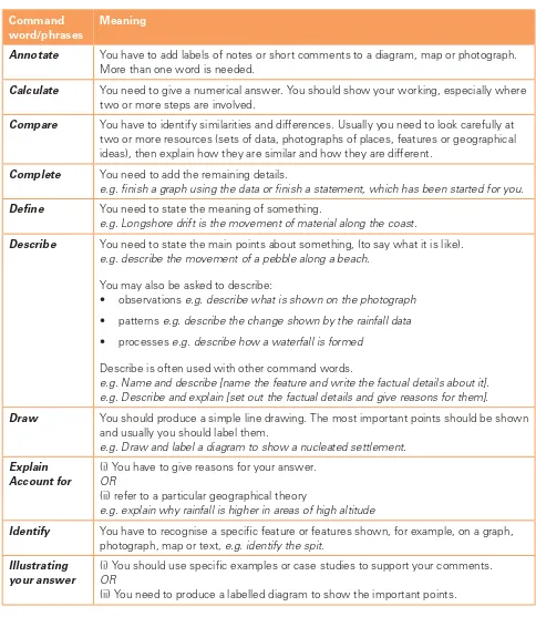
Section 6: Command words and phrases
We use command words to help you to understand what examiners are looking for in your answers. This table explains what each of these words or phrases means and will help you to understand the kind of answer you should write. The list of command words is in alphabetical order. You should remember that the meaning of a term may vary slightly depending on how the question is worded.
Command word/phrases
Meaning
Annotate You have to add labels of notes or short comments to a diagram, map or photograph. More than one word is needed.
Calculate You need to give a numerical answer. You should show your working, especially where two or more steps are involved.
Compare You have to identify similarities and differences. Usually you need to look carefully at two or more resources (sets of data, photographs of places, features or geographical ideas), then explain how they are similar and how they are different.
Complete You need to add the remaining details.
e.g. i nish a graph using the data or i nish a statement, which has been started for you.
Dei ne You need to state the meaning of something.
e.g. Longshore drift is the movement of material along the coast.
Describe You need to state the main points about something, (to say what it is like). e.g. describe the movement of a pebble along a beach.
You may also be asked to describe:
• observations e.g. describe what is shown on the photograph
• patterns e.g. describe the change shown by the rainfall data
• processes e.g. describe how a waterfall is formed
Describe is often used with other command words.
e.g. Name and describe [name the feature and write the factual details about it]. e.g. Describe and explain [set out the factual details and give reasons for them].
Draw You should produce a simple line drawing. The most important points should be shown and usually you should label them.
e.g. Draw and label a diagram to show a nucleated settlement.
Explain Account for
(i) You have to give reasons for your answer. OR
(ii) refer to a particular geographical theory
e.g. explain why rainfall is higher in areas of high altitude
Identify You have to recognise a specii c feature or features shown, for example, on a graph, photograph, map or text, e.g. identify the spit.
Illustrating your answer
(i) You should use specii c examples or case studies to support your comments. OR
Section 6: Command words and phrases
Command word/phrases
Meaning
Insert Label
You should add specii c names or details to show a feature or features.
List Write down a number of separate points. Where the number of points is stated, you should not write more than this number
e.g. list two advantages of random sampling.
Locate You have to i nd a place, usually on a map or graph.
Measure (i) You need to i nd a quantity using the measuring instrument given e.g. the maximum temperature from the max/min thermometer OR
(ii) calculate the distance on a map using the scale
Name You have to state or identify or give examples which illustrate a specii c feature.
Outline Give the main points briel y.
e.g. outline the impact of deforestation on the local people.
Pattern A particular arrangement or distribution e.g. settlements.
You may be asked to suggest a pattern or identify a pattern (or trend).
Refer to
With reference to
You should use some of the ideas from the resources provided in the question, or examples from your case study information.
State You should give a short answer without going into any detail.
e.g. state the type of migration when people move between countries.
Study You should look carefully at the information provided to answer the question. The examiner is often telling you where to i nd the answer with this command word.
Suggest (i) You should give your opinion based on the information given in the question. e.g. suggest where a split may develop.
(ii) You should apply your geographical knowledge or reasoning skills to a question. e.g. suggest why the shop was located in this area.
Use or Using the information provided
You should base your answer on the information provided.
Cambridge International Examinations