BIODIVERSITY THREATS ASSESSMENT FOR THE
WESTERN REGION OF GHANA
INTEGRATED COASTAL AND FISHERIES GOVERNANCE INITIATIVE FOR THE WESTERN REGION OF GHANA
Cooperative agreement # 641-A-00-09-00036-00
Implemented by the Coastal Resources Center University of Rhode Island
In partnership with: The Government of Ghana
Friends of the Nation SustainaMetrix The WorldFish Center
This publication is available electronically on the Coastal Resources Center’s website: www.crc.uri.edu. For more information contact: Coastal Resources Center, University of Rhode Island, Narragansett Bay Campus, South Ferry Road, Narragansett, RI 02882, USA. Email: [email protected]
Citation: K.A.A. deGraft-Johnson, J. Blay, F.K.E. Nunoo, C.C. Amankwah, 2010. “Biodiversity Threats Assessment of the Western Region of Ghana”. The Integrated Coastal and Fisheries Governance (ICFG) Initiative Ghana.
Disclaimer: This report was made possible by the generous support of the American people through the United States Agency for International Development (USAID). The contents are the responsibility of the authors and do not necessarily reflect the views of USAID or the United States Government.
Acknowledgements
The authors gratefully acknowledge the consultation and support provided by the Integrated Coastal Fisheries Governance (ICFG) team. Special thanks go to Dr. Brian Crawford of the Coastal Resources Center (CRC) at the University of Rhode Island, USA, and personnel of the CRC offices in Ghana—Dr. Mark Fenn, Program Director, Mr. Kofi Agbogah, Deputy Program Director, and Mr. Harry Barnes Dabban, National Policy Coordinator. We appreciate and thank as well the stakeholders from Ghana, especially the Western Region who assisted with interviews, and documents which helped to develop this report.
This report was produced as part of The Integrated Coastal and Fisheries Governance (ICFG) Initiative, Ghana—a four-year initiative supported by the United States Agency for International Development (USAID).
Authors
Mr. deGraft-Johnson, K.A.A. (Botanist) Prof. Blay, John (Fisheries Scientist)
Table of Contents
EXECUTIVE SUMMARY ...5
1.0 BACKGROUND ...8
1.1 PURPOSE OF THE DOCUMENT ... 8
1.2 BRIEF OVERVIEW OF THE ICFG PROJECT... 8
2.0 THE COASTAL ZONE OF GHANA ...10
2.1 COASTAL ZONE OF THE WESTERN REGION ... 11
3.0 MARINE AND COASTAL BIODIVERSITY ASSETS IN GHANA ...14
3.1 OVERVIEW OF BIODIVERSITY IN GHANA ... 14
Terrestrial Ecosystems ...14
Intertidal Ecosystem...15
Marine Ecosystem ...15
Freshwater Ecosystems ...19
4.0 MARINE AND COASTAL BIODIVERSITY ASSETS IN THE WESTERN REGION...20
4.1 COASTAL ECOSYSTEMS... 20
Marine Ecosystem ...20
Wetland Ecosystems ...22
4.2 TERRESTRIAL VEGETATION TYPES... 25
Zone of Saline Grasslands and Evergreen Shrubs and Thickets...27
4.3 INVASIVE SPECIES IN COASTAL WATERS... 27
4.4 SPECIES OF SPECIAL CONCERN AND FLAGSHIP SPECIES... 28
Marine Turtles ...28
Manatees...28
Dolphins ...29
Shore Birds...29
4.5 IMPORTANT BIRD AREAS (IBAs) AND BIODIVERSITY ‘HOT’ SPOTS... 29
Amanzule Wetland...30
Cape Three Points Forest Reserve ...32
Ankasa Conservation Area...32
5.0 THREATS TO TERRESTRIAL AND MARINE BIODIVERSITY CONSERVATION IN THE REGION ...36
5.1 INTRODUCTION ... 36
5.2 OVER EXPLOITATION OF MARINE FISHERIES RESOURCES ... 36
5.2.1 BY-CATCH OF ENDANGERED SPECIES ...37
5.3 LOSS OF COASTAL HABITATS ... 37
5.4 POLLUTION OF MARINE AND COASTAL ENVIRONMENT ... 38
5.5 COASTAL EROSION ... 38
5.8 WEAK GOVERNANCE, LEGISLATION AND INSTITUTIONAL
FRAMEWORK... 39
5.9 DEVELOPMENT OF OIL AND GAS RESOURCES ... 40
5.10 CLIMATE CHANGE... 40
5.11 INVASIVE SPECIES AND ALGAL BLOOMS... 41
5.12 HUNTING AND POACHING OF BUSH MEAT... 41
6.0 INSTITUTIONAL ARRANGEMENTS FOR BIODIVERSITY CONSERVATION IN GHANA ...42
6.1 INSTITUTIONAL ARRANGEMENTS... 42
6.2 INTERNATIONAL MEASURES RELEVANT TO BIOLOGICAL CONSERVATION IN GHANA ... 42
6.3 GOVERNMENT RESPONSE TO POLICIES AND INTERNATIONAL CONVENTIONS ... 43
6.4 ASSESSMENT OF THE GOVERNANCE EFFECTIVENESS FOR BIODIVERSITY CONSERVATION IN GHANA ... 44
6.5 EFFECTIVENESS OF GHANA’S PROTECTED AREAS FOR BIODIVERSITY CONSERVATION... 45
6.6 EFFECTIVENESS OF THE IMPLEMENTATION OF INTERNATIONAL TREATIES ... 45
7.0 CURRENT PRIORITIES FOR TERRESTRIAL AND MARINE BIODIVERSITY CONSERVATION...46
7.1 ESTABLISHMENT OF MARINE PROTECTED AREAS (MPAs) AND COASTAL RAMSAR SITES... 46
7.2 ADDRESSING HARMFUL ALGAL BLOOMS AND INVASIVE AQUATIC PLANTS... 46
7.3 FISHERIES MANAGEMENT REFORM ... 46
7.4 ENDANGERED SPECIES ... 47
7.5 OTHER NATIONAL AND REGIONAL PRIORITIES ... 47
8.0 RECOMMENDATIONS FOR TERRESTRIAL AND MARINE BIODIVERSITY CONSERVATION IN THE WESTERN REGION ...48
8.1 IMPROVED FISHERIES MANAGEMENT AND CONSERVATION... 48
8.2 PROTECTION OF EXISTING FOREST RESERVES... 48
8.3 LAGOONS AND WETLANDS PROTECTION ... 48
8.4 MANAGEMENT OF ALGAL BLOOM ... 48
8.5 TOURISM AND BIODIVERSITY CONSERVATION ... 49
8.6 AWARENESS CREATION ON HABITATS AND BIODIVERSITY VALUES. 49 8.7 CLIMATE CHANGE MITIGATION AND ADAPTATION ... 49
8.8 CAPACITY BUILDING... 49
8.9 RESEARCH PRIORITIES... 49
APPENDIX 1 Coastal Ramsar Sites Characteristics ...58
APPENDIX 2 Important Fishery Resources of Ghana (Aggrey-Fynn, 2007: from FAO Fishery Statistics 1983, 1987, 1998 and 2006) ..59
APPENDIX 3 Marine Fish Landings from the Four Districts of the Western Region- 2007-2008 ...60
APPENDIX 4 Percentage Composition of Marine Fish Landings from the Four Districts in the Western Region: 2007-2008 ...63
APPENDIX 5 Summary of Fisheries Resource Catches from the Districts (2007-2008) ...66
APPENDIX 6 Summary of Percentage Catch of Fisheries Resources from the Districts (2007-2008) ...67
APPENDIX 7 Institutions in Ghana Mandated to Implement Biodiversity Conservation Policies ...68
APPENDIX 8 LEGISLATIVE FRAMEWORK ...76
List of Figures
Figure 1: Maps showing the coastal zone of Ghana...10Figure 2: Map of Western Region (Source: www.ghanadistricts.com)...11
Figure 3: Map of southern Ghana showing the location of dead madreporarian corals ...20
Figure 4: Map of Western Region (Source: www.ghanadistricts.com) ..25
Figure 5: Forest Vegetation of the Western Region...25
Figure 6: Manatee Locations in Ghana ...29
Figure 7: Location and size of Important Bird Areas in Ghana...30
Figure 8: Fish Production in Ghana (1992-2004)...37
Figure 9: Wildlife Protected estates in Ghana ...70
List of Plates
Plate 1: Rocky Shore at low tide showing algae growth ...21Plate 2: Red mangrove forest at Amanzule River at Esiama...23
Plate 3: Edaphic savanna patches with Borasus palm Borasus aethiopum...30
Plate 4: Peat swamps with dead tree stumps in R. Ebi in Amanzule catchment ...31
List of Tables
Table 1: Population of the Coastal Districts of Western Region in 2000 11
Table 2: Vascular Plant Census of Ghana ...14
Table 3:Coastal Wetland Types ...22
Table 4: Depression Wetlands ...22
Table 5: Sea turtle species occurrence in the west coast of Ghana ...28
Table 6: Changes in national fishing fleet sizes from 1990-2002...36
EXECUTIVE SUMMARY
This report on the Biodiversity Threats Assessment of the Western Region of Ghana contains information obtained from public institutions, individuals, NGOs and published and unpublished literature. The situation in the Region is juxtaposed against the national condition to elucidate the peculiarities in its biodiversity assets.
The coastal zone of Ghana includes all land areas up to the 30 meter contour and the marine waters up to the 200 nautical mile Exclusive Economic Zone. The coastline stretches 550 km. The Western Region has an area of 21, 391 km2 (about 10 percent of the total land area of Ghana) with a 202 km long coastline. It comprises six coastal Ditricts- Jomoro, Ellembelle, Nzema East, Ahanta West, Sekondi-Takoradi Metropolis, and Shama.
Terrestrial vegetation types in the coastal zone of the Region include Sand Dunes with extensive coconut plantations, Wet Evergreen Forest, Moist Evergreen Forest, Moist Semi-Deciduous Forest, Grasslands and Evergreen shrubs occurring further inland.
The Region has many wetland systems some of which are freshwater habitats unlike the eastern coast of the country where the lagoons are typically brackish. Lagoons of importance in the Region are Tano/Aby/Ehy Lagoon at the coastal border between Ghana and Ivory Coast, and Amanzule Lagoon. While five wetlands in the country are designated as Ramsar Sites none is located in the Western Region.
The coastal marine resources of the Region include various species of pelagic and demersal fishes as in the coastal waters of other parts of the country with sardinellas (Sardinella aurita and Sardinella madarensis) as the most important. The wetlands in the Region are dominated by freshwater species notably Chrysichthys nigrodogitatus, and are nursery grounds for juveniles of some marine fishes. Invasive species found in the Region are the Water hyacinth Eichhornia crassipes in the Tano/Aby/Ehy lagoon and the seasonal blooms of the filamentous green alga Enteromorpha flexuosa in the coastal waters from Jomoro to Nzema East which constitute a nuisance to fishing and other economic activities.
The sandy shores of the Region are important nesting areas for endangered marine turtles; dolphins are landed at Dixcove and Axim and manatees could be found in the Tano/Aby/Ehy lagoon system while the Amanzule wetlands and Cape Three Points Forest Reserve are Important Bird Areas.
Threats to terrestrial and marine biodiversity in the Region are identified as
• Overexplitation of marine fisheries resources due to overcapitalization of the fishing industry, use of small mesh nets in the beach seine fishery and other illegal fishing methods
• Loss of coastal habitat through establishment of monocrop plantations, destruction of wetlands for infrastructure development, solid waste disposal, harvest of mangrove forests, beach sand mining and tourism development
• By-catch of endangered species like seabirds, sea turtles, sharks, dolphins and manatees from the use of nonselective gears in the fishing industry
• Accelerated coastal erosion from deforestation, sand and stone winning, and infrastructure development as the Takoradi Port and the nearby fishing harbor
• Increasing population density which could bring about an increase in the rate of exploitation of resources of fragile ecosystems
• Weak governance, legislation and institutional framework due to the fragmented nature of environmental legislation and lack of political will to enforce legislation
• Development of oil and gas resources which has the potential to increase conflicts with the fishing industry over the use of marine space, and its potential negative impacts on coastal and marine habitats
• Climate change and sea level rise which has the potential to severly impact the shoreline and further weaken the resilience of coastal habitats and biodivervsity and human communities
• Spread of invasive species such as the Water hyacinth Eichhornia crassipes in the wetlands and blooms of the green alga Enteromorpha flexuosa in the marine coastal waters could significantly hamper fishing activities and affect the livelihoods of coastal communtities
• There are a number of key government ministries, departments and agencies (MDAs) with policy and legislative functions affecting biodiversity management and conservation in the Western Region but with weak governance on biodiversity and habitats.
The current priorities for terrestrial and marine biodivervsity conservation in the Region:
• Establishing Marine Protected Areas and Coastal Ramsar Sites at the Amanzule wetlands and Esiama beach, and the Ahunli and Belibangara lagoons, because of their special biodiversity features
• Enact legislation for the complete protection and conservation of the Cape Three Points Forest reserve because the “Hot Spot” is under severe threats from anthropogenic activities.
• Addressing harmful algal blooms and invasive aquatic plants in wetlands and coastal marine habitat
• Undertaking fisheries management reform to ensure compliance with fisheries regulations
• Protecting endangered species such as marine turtles, cetaceans and manatees
• Completion, adoption and implementation of Policies, and Strategies and Action Plans for biodiversity conservation
In respect of the terrestrial and marine biodiversity conservation in the Western Region the following recommendations are made:
• Coordinated planning and utilization of coastal zone and resources
• Improved fisheries management and conservation
• Protection of existing forest reserves
• Awareness creation on habitats and biodiversity values
• Climate change mitigation and adaptation
• Strengthening relevant governmental and nongovernmental institutions through capacity building
1.0 BACKGROUND
1.1 PURPOSE OF THE DOCUMENT
This document is purported to present a review of existing information relating to threats to biodiversity conservation of coastal resources in Western Region of Ghana, to serve as a reference point for comparison with future change in the condition of coastal ecosystems and the governance system. The information would ultimately facilitate reconstruction of long term trends for key variables within the coastal zone. This threats assessment will also include information obtained through interviews with selected key informants and consultations with local experts.
It is generally acknowledged that the Coastal Zone of Western Region of Ghana has been severely and negatively impacted as suggested by the declining fisheries resources in the country as a whole and the destruction of aquatic and terrestrial habitats in the Region in particular. There is also the potential source of environmental damage from the exploitation of oil in the marine environment. The need for a study that highlights issues on conservation of aquatic and terrestrial environments and their biodiversity cannot therefore be overemphasized. Such a study would provide a basis for initiating actions for recovery of the depleted fisheries, conservation of endangered species of birds, reptiles and mammals, restoration of degraded land and aquatic habitats, and reducing marine and land-based pollution through establishment of a management frame work for sustainable use of the coastal resources. Such actions would in the long run benefit the communities in socio-economic terms.
The objectives of this assessment are to:
• Identify and document areas of coastal and marine biological significance in Ghana and their assets
• Identify and analyze key threats to these biodiversity assets
• Provide orientations for further priority research activities that are needed to design and implement biodiversity conservation strategies and actions
• Provide recommendations on how the ICFG Program can address these threats
1.2 BRIEF OVERVIEW OF THE ICFG PROJECT
The Integrated Coastal and Fisheries Governance (ICFG) Initiative is a four-year initiative supported by the U.S. Agency for International Development (USAID). It is implemented through a cooperative agreement with the Coastal Resources Center (CRC) University of Rhode Island (URI) United States of America (USA).
The stated goal of the ICFG Program is: to support the government of Ghana in achieving its development objectives of poverty reduction, food security, sustainable fisheries management and biodiversity conservation by contributing to the following vision: Ghana’s coastal and marine ecosystems are sustainably managed to provide goods and services that generate long term socio-economic benefits to communities while sustaining biodiversity.
2.0 THE
COASTAL
ZONE OF GHANA
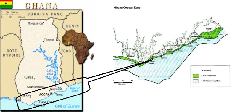
Ghana lies along the Gulf of Guinea (30 5´ W and 1010´ E and 40 35´N and 110 N) and has an area of about 239,000 km2 and a 550 km coastline with about 90 lagoons and associated wetlands. Some of the lagoons are closed and others open (Boughey, 1957; Kwei, 1977; Mensah, 1979).
Ghana’s coastal zone encompasses a land area extending to the 30 meter contour, and a coastal offshore shelf area to either the end of the continental shelf or the 200 nm exclusive economic zone limit (EPA/WB 1996; Armah & Amlalo, 1997) (Fig.1). However, for management purposes the definition includes land areas within the 75 meter contour. The landward zone is generally low lying, not more than 200 m above sea level while the continental shelf is narrow extending outwards to between 25 km and to 35 km except off Cape Coast to Saltpond where it reaches up to 80 km.
The coastal zone covers 6.5% of land area but is inhabited by a quarter of the population. The zone contains 21 Districts in four administrative regions namely Western (4 Districts), Central (7 Districts), Greater Accra (5 Districts) and Volta Region (5 Districts) (EPA/WB, 1996). In 2008, 5 new Districts were created increasing the number to 26 nationally and six for the Western region.
Figure 1: Maps showing the coastal zone of Ghana
2.1 COASTAL ZONE OF THE WESTERN REGION
The Western Region is approximately 21,391 km2 (about 10 per cent of Ghana’s total land area) with a 202 km long coastline. About 75 per cent of Ghana’s high forest vegetation occurs in the Region. It is also the wettest part of the country with an average rainfall of 1,600 mm per annum. The Region is bordered on the east by the Central Region, the west by Ivory Coast, the north by Ashanti and Brong-Ahafo Regions, and the south by the Gulf of Guinea. The southernmost part of Ghana lies in the region, at Cape Three Points near Busua, in the Ahanta West District.
Figure 2: Map of Western Region (Source: www.ghanadistricts.com)
The 2000 population and housing census indicted a population of 1.92 million for the Western Region (Ghana Statistical Service, 2005) and the distribution for the then four Districts is shown in Table 1. The Region presently has six coastal Districts namely Jomoro, Ellembelle, Nzema East Municipality, Ahanta West, Sekondi-Takoradi Metropolis, and Shama
Table 1: Population of the Coastal Districts of Western Region in 2000
DISTRICT JOMORO NZEMA EAST AHANTA WEST SHAMA AHANTA EAST
POPULATION 111,348 142,871 95,140 369,166
Jomoro District
The project has succeeded in attracting two local private investors to develop beach resorts near Ekabaku and Ngelekazo.
The District has a number of wetlands ecosystems, the major ones being the Amanzule, located near Beyin, Dormuli and Aby wetlands. The Amanzule is the only known intact swamp peat forest in Ghana. The famous 500 years old Nzulezo village where houses are built on stilts and traditional life adapts to the watery conditions is built on the Amanzule Lagoon. The area has already been designated as an Important Bird Area based on Birdlife International criteria. The Government is currently, taking steps to designate the Amanzule wetlands, including some wetlands in Nzema East, and Ellembele as Ramsar Sites (MLFM, 2007). The Dormuli wetland although small has intact and beautiful mangrove forest and estuary and is inhabited by monkeys, crocodiles, marine turtles and birds. The Abby Lagoon is a transboundary wetland important to both Ghana and Ivory Coast due to its high productivity especially fish. The West African manatee (Trichechus senegalensis) has been reported in the Abby Lagoon (Ofori-Danson and Agbogah, 1995).
The marine environment in the district has the potential for sea tourism, watching sea animals such as whales, dolphins and turtles. From mid-July to October a number of whales and dolphins visit the seas in the District while August to March is the nesting season for turtles.
Nzema East Municipality
The Nzema East Municipality is about 2,194 km2 representing 9.8 percent of the total area of the Western Region. It has some 70 kilometres of sandy beach. The District is rich in tourism attractions although most of these are still undeveloped. It has beautiful sandy beaches which can be developed for conventional beach tourism. The Ankobra River is another tourist attraction for river boat trips.
Ellembelle District
Shama District
Like the Ellembelle district, the Shama district with its capital Shama forms part of the new districts and municipalities created in February 2008. Relevant data concerning its location and size, topography and drainage, climate and vegetation, geology and soil, social infrastructure, economy conditions are not currently available.
Ahanta West District
The Ahanta West District (4° 45´N and 1° 58´W) is located at the southern most part of the country with its capital as Agona Nkwanta also called Agona Ahanta. It has a total land area of 591 km2 with a population of 95,140 according to the 2000 Population and Housing Census report (Ghana Statistical Service, 2005).
The District has some beautiful beaches suitable for swimming and sunbathing at Egyambra, Miamia, Princess Town, Akwidaa, Busua, Butre and Adjoa. Butre, Miamia and Cape Three Points are also noted for the occurrence of a variety of shellfish. Cape Three Points is part of the migratory route for whales, dolphins and sharks which calls for its consideration as a Marine Protected Area (MPA). The Cape Three Points Forest Reserve which occupies a total area of 51,102 km2 is the only primary forest in Ghana located very close to the sea. Though now at risk from encroachment and poaching, the reserve has a wide variety of tree species, butterflies, monkeys and birds. Importantly, the different plants have medicinal value. Also of significance in the District is the Egyambra crocodile pond and shrine located about 10 kilometres west of Princess Town.
Sekondi-Takoradi Metropolis
3.0 MARINE AND COASTAL BIODIVERSITY ASSETS IN
GHANA
3.1 OVERVIEW OF BIODIVERSITY IN GHANA Terrestrial Ecosystems
Ghana lies in the Upper Guinea Forest Ecosystem, extending from Guinea to Sierra Leone and eastward to western Togo. This ecosystem is biologically rich and because of its high degree of species endemism is considered as one of the world's priority biodiversity conservation areas (Conservation International, 1999).
Two main vegetation types, the forest and savannah are peculiar to Ghana. The forest is subdivided into Wet Evergreen, Moist Evergreen, Moist Semi-deciduous, Dry Semi-deciduous, Upland evergreen and Southern marginal, South-east outliers and Mangroves (Hall and Swaine, 1981). The savannah is variously described as Coastal savannah in the eastern coastal belts, the Northern Interior wooded savannah found mainly in the south central northern zone, and Drier Sudan wooded savannah in the north east corner of the country (World Bank, 2002). About 6.4 percent (353,000 hectares) of the land area of Ghana is occupied by primary forest with a closed forest zone located in the south-west of the country (http://rainforests.mongabay.com/deforestation/2000/Ghana.htm).
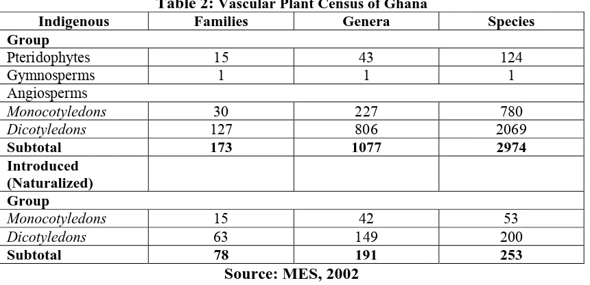
There are over 3600 plant species in Ghana (MES, 2002) of which 2,900 are indigenous, 250 are introduced species and 43 species are endemic. Table 2 shows the numerical representation of vascular plants in Ghana. The flora in the southwest forests has the highest diversity. Most of the forests are located on substrates rich in gold, diamonds and bauxite.
Table 2:Vascular Plant Census of Ghana
Indigenous Families Genera Species Group
Pteridophytes 15 43 124
Gymnosperms 1 1 1
Angiosperms
Monocotyledons 30 227 780
Dicotyledons 127 806 2069
Subtotal 173 1077 2974
Introduced (Naturalized) Group
Monocotyledons 15 42 53
Dicotyledons 63 149 200
Subtotal 78 191 253
Source: MES, 2002
Thirty-one species of amphibians have been recorded in the Volta Region (National Biodiversity Strategy & Action Plan, 2002). Three frog species, one lizard species and 23 species of butterflies are endemic to Ghana (MES, 2002). Bobiri Forest Reserve contains over four hundred species of butterflies and an estimated 550 butterfly species have been recorded in Kakum National Park. The species of concern is the rare African giant swallow tailed butterfly.
Crocodiles are rare but occur in some rivers and streams, and in the Volta Lake. Large populations occur in the protected Paga crocodile pond in the Upper East Region. Three species of crocodiles namely the slender-snouted crocodile Crocodylus cataphractus, the dwarf crocodile Osteolaemus tetrapsis, and the Nile crocodile
Crocodylus niloticus have been identified in the country.
Intertidal Ecosystem
Mangrove forests in Ghana are sparse and are associated with coastal lagoons and estuaries (Hughes and Hughes, 1991). In 1995, the total land area covered by mangroves was estimated at 10,000 ha (Saenager and Bellan, 1995) and is expected to have been significantly reduced currently. Good mangroves stands are restricted to three main areas: the Amanzule wetlands in the Western Region, the Kakum River estuary west of Cape Coast (Central Region), and the Volta Delta.
Five species of mangroves are found in Ghana- the red mangroves, Rhizophora racemosa, Rhizophora mangel and Rhizophora harrisonii and the white mangroves
Avicennia germinans and Laguncularia racemosa. The red mangroves occur in open lagoon systems which have regular tidal exchange whereas the white mangroves are primary colonists of closed lagoons (Sackey et. al., 1993). The richest diversity of mangroves occurs in the flood plains of the Kakum River at Iture which contains all five species of mangroves.
Marine Ecosystem Seagrass beds
Seagrass beds are rare in the coastal waters of Ghana due to unfavorable environmental conditions such as relatively high turbidity which inhibits their growth. However, Armah & Amlalo (1998) have reported the occurrence of the seagrass
Rupia maritima in the Keta lagoon. R. maritima has also been reported from the Fosu lagoon in Cape Coast and an irrigation dam at Mankesim (deGraft-Johnson pers. com.).
Plankton
fishery of the nearshore and adjoining coastal water bodies. It has been reported (Mensah, 1966) that maximum occurrence of the zooplankton copepod Calanoides carinatus during the upwelling season in Ghana is related to the seasonal abundance of Sardinella species in the coastal waters.
Littoral invertebrates
The sandy beach fauna is dominated by the ghost crab, Ocypoda cursor, and the rocky beaches by bivalves, whelks, limpets and crabs e.g. Grapsus grapsus. Other commonly encountered fauna include isopods, amphipods, mysids and polychaetes. The littoral benthic organisms include polychaetes, arthropods, bryozoans, and echinoderms. Edmunds (1978) recorded 68 taxonomic families. Some species such as the gastropods Cymbium spp. and the spiny lobster Panulirus sp. appear to be declining in abundance while the sea star Astropecten sp. and other starfishes have completely disappeared.
Macroalgae
Various species of green algae, brown algae and red algae are present in Ghana waters. However since 1993 annual blooms of the filamentous green alga
Enteromorpha flexuosa have been reported in western Ghana, a phenomenon of major concern to fishermen and other users of the coast.
Marine fish
About 347 fish species belonging to 82 taxonomic families have been recorded in Ghana. The marine fish resource exploited by artisanal, semi-industrial and industrial fishery sectors is classified into small pelagics, large pelagics, demersals, and shellfishes comprising crustaceans and molluscs (Mensah and Quaatey (2002). Appendix 2 shows the different categories of fish and their representative species. Marine fish production is largely dependent on the strength of the seasonal upwelling phenomenon (Mendelsshon and Cury, 1987) and rainfall (Biney, 1982). A major upwelling period occurs between June and September whilst a minor upwelling period occurs between December and February (Mensah, 1983). The total fishery production of Ghana averages 300,000 metric tons per annum (Anon, 2003). According to Kwei and Ofori-Adu (2005) the annual production averages are 240,000 metric tons for small pelagics (sardinellas, anchovy, chub mackerel, etc.), 36,000 metric tons for large pelagics (tunas, skipjacks, etc.), 40,000 metric tons for demersal fishes (breams, carangids, snappers, groupers, etc.) and 260 metric tons for shellfishes (shrimps and lobsters).
Small Pelagic Fish
Annual catches of S. aurita were below 40,000 mt until 1972 when the fishery for the species virtually collapsed following the landing of about 90,000 mt of the species that year, but catches improved substantially to reach 51,000 mt in 1978 comparable to that of pre-collapse years (Mensah, 1981).
Other small pelagic fishes of economic importance are the chub mackerel (Scomber japonicus), scads (Decapterus spp.), jack mackerels (Caranx spp.), horse mackerels (Trachurus spp.), the bumper (Chloroscombrus chrysurus), and the anchovy (Engraulis encrasicolus) (Mensah and Koranteng, 1988).
Large Pelagic Fish
Large pelagic fish of commercial importance in Ghana are tunas and tuna-like species, e.g. the yellowfin tuna (Thunnus albacares), bigeye tuna (Thunnus obesus), skipjack (Katsuwonus pelamis), little tunny (Euthynnus alletteratus), Atlantic bonito (Sarda sarda), Auxis thazard (Frigate mackerel), Atlantic sailfish (Istiophorus albicans) and the broadbill swordfish (Xiphias gladius) (Mensah and Koranteng, 1988). The capture of these large pelagics with drift gill nets often results in the accidental capture of sea turtles and dolphins.
Demersal Fish
Demersal fishes are caught by trawlers and some artisanal gears like beach seines, set nets and long-lines (Mensah and Koranteng, 1988). The most important of these are sea breams mainly the red Pandora (Pagellus bellottii), Canary dentex (Dentex canariensis) and blue-spotted sea bream (Sparus caeruleostictus), burros (Pomadasys
spp.), the burrito (Brachydeuterus auritus), croakers (Pseudotolithus spp.), snappers (Lutjanus spp. and Lethrinus spp.), red mullets (Psedupeneus prayensis), groupers (Epinephelus spp.) and threadfins (Galeoides decadactylus, Polydactylus quadrifilis
and Pentanemus quinquarius).
Shellfish
Lagoon and Estuarine Fish
A number of the coastal lagoons have a high productivity and are exploited for their fisheries resources on subsistence and commercial basis. Pauly (1976) estimated a production of 120 kg/ha for Sakumo Lagoon near Tema, and Blay and Asabere-Ameyaw (1993) determined production values of 452-664 kg/ha for Fosu Lagoon in Cape Coast.
The fish fauna of a number of lagoons and estuaries have been documented. The dominant species in most lagoons belong to the Cichlidae, notably the black-chinned tilapia Sarotherodon melanotheron which makes up 80% to 99% of the fish biomass (Pauly, 1975, 1976; Ntiamoa-Baidu, 1991; Blay and Asabere-Ameyaw, 1993; Koranteng et al., 1998, 2000).The remaining fish fauna are freshwater and marine elements. Juveniles of marine fish are notably common in open (tidal) lagoons (Mensah, 1979, Pauly, 1975, 1976; Blay, 1998).
Sea turtles
Sea turtles (Leatherback Demochelys coriacea, Hawksbill Eretmochelys sp., Green turtle Chelonia mydas, Loggerhead Caretta caretta, Olive-Ridley Lepidochelys olivacea) which are listed as endangered are found in Ghana.
Birds
Of the 728 bird species occurring in Ghana, 408 are non-passerine and 320 are passerine. It is also believed that 494 are resident and 176 are regular seasonal migrants including 100 from the Palaeartic region. Of the total number of species recorded 180 are restricted to the Guinea-Congo Forest biome and 37 to the Sudan-Guinea Savannah biome (Ntiamoa-Baidu et al. 2001). Furthermore, 11 of the 15 endemic bird species within the Upper Guinea Forest occur in Ghana. Six of the total species are considered threatened and 12 near-threatened (BirdLife International, 2000). The country is also important for water-birds, being on the boundary of the East-Atlantic flyway and the Mediterranean flyway (Smith & Piersma, 1989; Ntiamoa-Baidu et. al, 2001).
There are 36 important Bird Areas (IBA) in Ghana according to Birdlife International for critical bird habitats in Ghana of which six occur along the coast including the Amanzule wetlands in the Western region. Most of the coastal wetlands harbor about 70 species of resident and migratory bird life (Ntiamoa-Baidu et al., 2000).
Marine mammals
Dolphins have been reported in the coastal towns of Apam, James Town, Ningo-Prampram and Keta (Debrah, 2000, Ofori-Danson, et al., 2003). Migratory dolphins, mainly Stenella and Delphinus spp., are ’common. Sharks are normally caught together with dolphins (Risso’s dolphin Grampus griseus, Atlantic spotted dolphin
Stenella frontalis) in drift gill nets. Shark species of the family Carcharinidae dominated by Rhizopionodon acutus are mostly landed. Whales e.g. the humpback
Freshwater Ecosystems
Fresh water ecosystems include the rivers and streams, lagoons, a number of man-made lakes notably Lake Volta, and Lake Bosomtwi, the only natural lake in the country.
Fish
Ghana's freshwater fish includes 28 families, 73 genera and 157 species. About 121 species have been recorded from the Volta system, which drains a major part of the country. It is estimated that about 124 fish species from 62 genera and 26 families inhabit the major rivers (MES, 2002). Eighty one species are of food importance and species of cultural importance include Chrysichthys nigrodigitatus, Clarias gariepinus, Heterobranchus longifilis, andHeterotis niloticus, (MES, 2002).
Manatees
The West African manatee (Trichechus senegalensis) is globally classified as vulnerable by the International Union for Conservation of Nature and Natural resources (IUCN). It occurs in large rivers and coastal waters of West Africa including Ghana; however, no assessment of the manatee population has been carried out in this country. Large numbers of manatee have been reported by hunters in the Tano and Afram Rivers (Ofori-Danson and Agbogah, 1998), and Avu lagoon (Hadja, pers. com). In one dry season, over 40 manatees were reported killed in the Avu lagoon. A hunter was reported to have killed over 17 individuals in the Afram River. Fishermen in the Lower Volta wetlands as well as in the Afram and Digya wetlands have reported fewer sightings of manatees of late compared to periods prior to impoundment of the Volta River (Hadza, pers. com, Ofori-Danson and Agbogah 1998).
Ungulates
4.0 MARINE AND COASTAL BIODIVERSITY ASSETS IN THE
WESTERN REGION
4.1 COASTAL ECOSYSTEMS
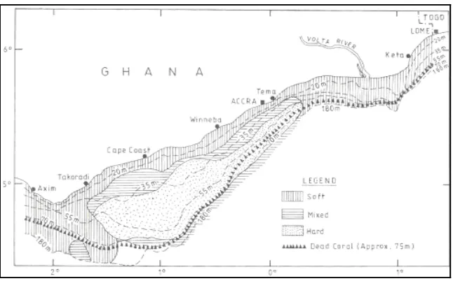
Marine Ecosystem Madreporarian corals
The continental shelf of the western region is traversed by a belt of dead madreporarian coral from 75 m depth. Beyond this coral belt, the bottom falls sharply, marking the transition from the continental shelf to the slope (Figure 3).
Figure 3: Map of southern Ghana showing the location of dead madreporarian corals
Sandy Shores
In the Western Region sandy beaches occur over a distance of 72 km from the Amanzule estuary to New-Town on the Ghana-Ivory Coast border. Sandy beaches can also be found near the Pra, Whin and Butre estuaries.
Rocky Shores
Rocky beaches occur at Takoradi, Princess town, and Axim with considerable colonization by barnacles (Plate 1). They also support a wide variety of macroalgae which serve as important microhabitats for epifauna and fish. There are also a wide variety of molluscs, and crustaceans including littorinid snails and crabs.
Plate 1: Rocky Shore at low tide showing algae growth
(Source: EPA, 2004)
Marine Fisheries
Fish Species Composition
Composition of finfish and shellfish species in catches of the four Districts (combined data for 2007 and 2008) are presented in Appendices 3 and 4. Forty-eight species of finfish and unidentified sea breams, snappers, groupers, sea catfishes, rays and sharks occur in the catches from the area. Two species of shellfish plus unidentified shrimps are present in the catches from the Region. Small pelagic fish are the most important in the fisheries followed by large pelagic fish and demersal fish. The most important small pelagic fishes include the round sardinella, Sardinella aurita, the flat sardinella
Sardinellamadarensis, the long-finned herring Ilisha africana and the chub mackerel
Scomber japonicus. Important large pelagic fishes as the skipjack tuna Katsuwonus pelamis, Atlantic sailfish Istiophorus albicans and blue marlins Makaira nigricans are found in Shama-Ahanta East and Nzema East, and the flying fish (Exocoetidae) in Ahanta West. Large pelagic fishes are however absent in the Jomoro catches apparently because the main fishing activity is beach seining which targets the resources in shallow coastal waters.
Wetland Ecosystems
Ten wetlands types based on the classification of the Ramsar Convention on Wetlands (Ramsar, Iran, 1971) occur in the coastal zone of Ghana (Gordon, et. al., 1998). The wetland types occurring in the Western Region are shown in Table 3. Unlike lagoons in the eastern coast of Ghana, several Western Region lagoons are freshwater due to the high precipitation in the area (> 2000 mm per annum) engendering high freshwater runoff and stream flow into the wetlands (Finlayson et al., 2000). Some of these are “depression wetlands” with no connection to major water courses (Table 4). Lagoons of importance in the Western Region are Tano/Aby/Ehy Lagoon (410 km2) and Amanzule Lagoon (2.5 km2) near Benyin both in Jomoro District. The latter has been proposed for designation as a Ramsar Site. Other lagoons in the Region are relatively small (<1 km2). Major rivers and their associated estuaries are also located in the coastal area. These are Tano, Amanzule, Ankobra, Butre and Pra River. Red mangroves (Rhizophora harisonii, Rhizophora mangle, and Rhizophora racemosa) with their distinct prop roots are common in these estuarine wetlands where there is mixing of fresh and saline waters (Plate 1).
Table 3:Coastal Wetland Types
Type Example/Location Shallow marine water Entire coast
Rocky marine shores Cape Three Points, Dixcove, Axim Estuarine waters Ankobra, Butre, Whin, Pra estuaries Salt marshes Whin River estuary
Mangrove tidal forest Ankobra, and Pra estuaries
Brackish/saline lagoons Open lagoons, e.g. Butre, Whin, Esai Closed lagoons, e.g. Ahunli,
Coastal freshwater lagoons Belibangara, Ndumakaka, Efasu lagoon (Source: WB/EPA, 1996)
Table 4: Depression Wetlands
Name Size (km2) Uses
Belibangara 0.5 WH, F
Ndumakaka 0.2 WH
Efasu 0.3 WH
Ehuli 1.4 WH, F
WH = wildlife habitat; F = Fishing
Plate 2: Red mangrove forest at Amanzule River at Esiama
(Photo credit: F. K. E. Nunoo)
Wetland Vegetation
In the Western Region mangrove stands are best developed between Cape three Points and Ivory Coast. These stands are restricted in area and usually found as thickets at estuaries and along some lagoons (Hughes and Hughes, 1991). The lagoon mangroves exhibit zonation of communities. Typically Rhizophora and Laguncularia species arre found on the seaward side of saline lagoons whilst Avecinnia is found on the landward side of the swamps (FAO/UNEP, 1981). In the open shoe mangroves are generally absent.
In “Open” lagoons, Rhizophora are common in main channels whilst Avecinnia
species occur in the quieter backwaters. In “Closed” lagoons where salinities can be very high Avecinnia predominates with Rhizophora normally absent (Ewer and Hall, 1972). Mangroves are typically accompanied in the marshes by the fern Acrostichum aureum and grass Paspalum vaginatum.
Fresh and sometimes near brackish swamp forests have fewr large tress which include
Hallea stipulosa and H. ladermanii. Other swamp vegetation includes raphia palms (Raphia palma-pinus, R. hookeri and climbing palms (Calamus deeratus and
Lacosperma secondiflora).
Wetland Fisheries
Aby Lagoon
Dankwa and Abban (1996) identified 27 species belonging to 25 genera and 18 families while Dankwa et al. (1997) reported 33 species from 20 families in this lagoon. The fishes include freshwater, brackish water and marine elements but freshwater fish are dominant. Fishes of the Family Bagridae (26%) dominate the community of 11 families from the littoral areas while the 15 families in open waters are predominantly Mugilidae (37%). The high incidence of freshwater species in the lagoon has been attributed to the high influx of freshwater from the Tano River (Dankwa and Abban, 1996).
(Abban and Dankwa, 2001; Entsua-Mensah and de Graft-Johnson, 2004) with numerical compositions as follows: Chrysichthys nigrodigitatus (60%), Hepsetus odoe (12.4%), Hemichromis fasciatus (8.1%), Brycinus longipinnis (8%), Tilapia guineensis (5.9%), Sarotherodon melanotheron (4.8%), and Parachanna obscura
(0.5%).
Abban and Dankwa (2001) have also reported five species mainly Chrysichthys nigrodigitatus (75%) in the Amanzule Estuary including two marine species (Mugil bananensis, 6.3% and Elops senegalensis, 6.3%). The black-chinned tilapia
Sarotherodon melanotheron, which dominates many lagoons on the eastern shores of Ghana (Pauly, 1975, 1976; Ntiamoa-Baidu, 1991; Blay and Asabere-Ameyaw, 1993), constitutes just 6.3% of the fish community Amanzule Estuary.
Other Lagoons
Lists of the fish fauna found in a number of smaller lagoons in the Western Region have been provided by Dankwa et al. (1997) with species richness ranging between 3 species and 26 species. Most of the communities are represented by freshwater, brackish water, and marine species.
Ankobra and Pra Estuaries
The available information on the fishes of estuaries of the Ankobra and Pra Rivers is a checklist of the species found in these waters (Dankwa et al., 1997). Of the 31 species found in the Ankobra Estuary 25 species are from the sea. The only freshwater elements are Chrysischthys nigrodigitatus (Bagridae) and the Cichlidae species
Tilapia zillii, T. guineensis and Sarotherodon galilaeus. The black-chinned tilapia
Sarotherodon melanotheron and the goby Periophthalmus barbarus (designated as
Periophthalmus papilio in the list) are the only typically brackish water fish recorded in the list.
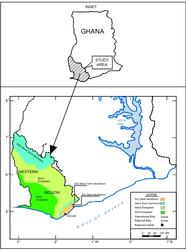
4.2 TERRESTRIAL VEGETATION TYPES
The coastal terrestrial vegetation types of the Western Region are shown in Figures 4a and 4b. Moist-sem i decidu ous f orest Rain forest Stra nd and m ang rove zon e
LEGEND
Figure 4: Map of Western Region (Source: www.ghanadistricts.com)
Vegetation of the Coastal Zone of Ghana
3° 2° 1° W 0°
Forest Vegetation
The Rain Forest is made up of the Moist Evergreen (ME) and Wet Evergreen (WE) Forests
Wet Evergreen (WE) Forest
The wet evergreen forest is restricted to the highest rainfall (1500-2100 mm) areas and contains the highest concentration of rare and endemic species in the country (Hawthorne and Abu-Juam, 1993). It is the least disturbed forest type in Ghana and is reasonably well represented in the Nini-Suhien National Park and Ankasa Resource Reserve where the only endemic forest genus, Monocyclanthus (Annonaceae), is found.
Moist Evergreen (ME) Forest
This forest type is located in areas that receive 1500 to 1750 mm of rainfall and is usually found between the WE to the south and the Moist Semideciduous (MSD) forest to the north. The flora is slightly less diverse than the WE but contains more commercial timber tree species and has, therefore, been more heavily impacted by logging. Timber trees of economic value include Khaya ivorensis (African mahogany), Triplochiton scleroxylon (African white wood) and Terminalia ivorensis
(Ivory Coast almond).
Moist Semi-Deciduous (MS-D) Forest
This forest type is found in areas with annual mean rainfall between 1250 mm and 1700 mm. It is the most productive although species diversity is relatively lower than the ME and represents about 40 percent of the closed forest zone. Two subtypes are recognized; the drier northwest subtype, where forest elephant populations occur, and the southeast subtype. This type of forest can be found at the Bia National Park and Ajenjua Bepo.
Dry Semi-Deciduous (DSD) Forest
Coastline Vegetation
Zone of Saline Grasslands and Evergreen Shrubs and Thickets
The saline grassland zone is characterized by salt tolerant grasses like Paspalum vaginatum, Sporobolus robustus, the rhizomatous sedge Cyperus articulatus and the succulent forb Sesuvium portulacastrum foun madreporarian corals d nearer to the shore of lagoons. Further landwards on floodable higher ground are grasses such as
Brachiaria distachyoides, Imperata cylindrica, Panicum repens, tall grasses such as
Andropogon gayanus, and Vetiveria fulvibarbis. Others are the herbs Cassia mimosoides and Croton lobatus, and sedge Fimbristylis pilosa.
The coastal evergreen shrubs and thickets zone originally formed a narrow band, usually less than 1 mile wide and has fewer indigenous woody plants but most of it has now been cleared for coconuts. This thicket is not of the compact thorny type found further east, but is more open, consisting of bushes and small trees, many of them belonging to the Rubiaceae. The commonest species is Syzygium guiñéense, a shrub or tree with shiny leaves and purplish black edible fruits, which is often associated with Dialium guineense, Chrysobalanus ellipticus, Gaertnera paniculata, Uvaria globosa, Baphia nitida, Ochthocosmus chippii and species of Canthium and
Ixora.
Sand Dune Vegetation
Coconut (Cocos nucifera) plantations dominate the dunes whilst the ground cover is dominated by rhizomatous and straggling species including the sedges Cyperus maritime and Remirea maritime, the herbs, Alternanthera maritima, Canavalia rosea,
and Ipomoea pes-caprae,and the grasses Paspalum vaginatum, Sporobolus robustus
and S. virginicus. The creeping succulent forb Sesuvium portulacastrum, Philoxerus vermicularis, and xerophytes Euphorbia glancophyll and Opuntia vulgaris exist in the zone. Occasionally Thespesia populnea and the Indian almond Terminalia catapa
may also occur.
4.3 INVASIVE SPECIES IN COASTAL WATERS
The Tano/Abby/Ehy lagoon complex on the south west border of Ghana and Ivory Coast has a large population of invasive plants notably the water hyacinth Eichhornia crassipes, the Kariba weed Salvinia molesta, water lettuce Pistia stratiotes and the Hippo grass Vossia cuspidata. Up to 25 km of the shoreline of the lagoon on the Ghanaian side is covered by these weeds (EPA, 2004) thus inhibiting transportation of goods and people between the two countries. The weeds have caused a reduction in fish catches (Holcik, 1995), and there is evidence of total blockage of the River Tano at times. Dense green filamentous algal blooms identified as Enteromorpha flexuosa
4.4 SPECIES OF SPECIAL CONCERN AND FLAGSHIP SPECIES
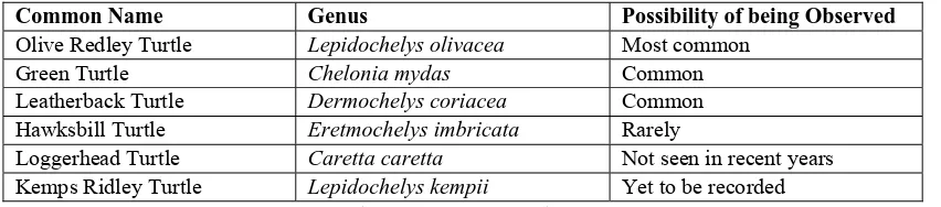
Marine Turtles
GWS (2000) has reported that the 72 km stretch of beach from the Amanzule estuary to New-Town on the Ghana-Ivory Coast border in the Western Region is a major turtle nesting area. Few turtles have also been found nesting on the sandy beaches of Butre, Princess Town, Miamia and Axim. The Olive Ridley, the Green and Leatherback turtles are common during the nesting season (Table 5). Major beaches in the region important for turtle nesting and conservation occur at Butre, Busua, Akwida, Azile, Cape Three Points, Axim, Beyin, Ankobra, and Half Assini (Doak, 2009).
Table 5: Sea turtle species occurrence in the west coast of Ghana
Common Name Genus Possibility of being Observed Olive Redley Turtle Lepidochelys olivacea Most common
Green Turtle Chelonia mydas Common Leatherback Turtle Dermochelys coriacea Common Hawksbill Turtle Eretmochelys imbricata Rarely
Loggerhead Turtle Caretta caretta Not seen in recent years Kemps Ridley Turtle Lepidochelys kempii Yet to be recorded
(Source: Doak, 2009)
Manatees
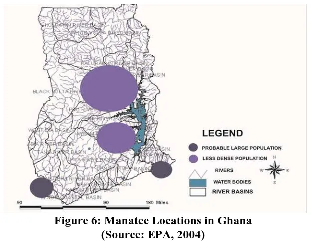
Roth and Waitkuwait (1986) and Powell (1996) reported that the West African manatee (Trichechus senegalensis) might occur in the Abby/Tano/Ehy Lagoon complex. However, studies conducted by the Institute of Aquatic Biology of the Council for Scientific and Industrial Research (CSIR) and the Wildlife Department in Ghana indicate they do occur in the Tano river and the Tano/Abbey/Ehy Lagoon complex (Entsua-Mensah and Ankudey, 1995). Locations of manatees in Ghana are shown in Fig. 6.
Figure 6: Manatee Locations in Ghana (Source: EPA, 2004)
Dolphins
Dolphins occur as bycatch in the fisheries of some areas in the region. Three species have been reported at Dixcove and Axim (Debrah, 2000; Ofori-Danson, 2003).
Shore Birds
The shorebirds in Western Region include various species of waders and terns (GWS Annual Report, 2001, 2002/2003). Other coastal birds found in the Region include ducks, cormorants, herons and egrets. The most abundant species include the white-face tree duck, little egret and the Western reef heron (GWS Annual Reports 2000, 2001, 2002/2003).
The beach at Esiama, reported to host about 10,000 shore birds annually (EPC, 1990), and the River Whin estuary are important bird sites (GWS Annual Report, 2001). The Amanzule wetlands are also among the 36 Important Bird Areas (IBAs) designated by Birdlife International in Ghana (Birdlife International, 2009).
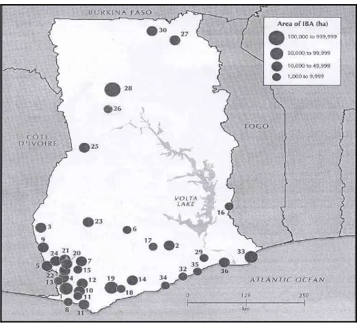
4.5 IMPORTANT BIRD AREAS (IBAs) AND BIODIVERSITY ‘HOT’ SPOTS
Figure 7: Location and size of Important Bird Areas in Ghana (Source: Ntiamoa-Baidu, et al., 2001).
Amanzule Wetland
The Amanzule wetlands (4º 55' N 20º 15' W) covers an area of 3.8 km2. The area is designated as an IBA by Birdlife International and has been proposed for listing under the Ramsar Convention in the National Wetlands Conservation Strategy and Action Plan (2007-2016) (MLF, 2007).
The soils of the basin belong to the Fredericksburg association. There are two main series in evidence. The Mpataba series is a black, acid, peaty soil. It is formed under waterlogged conditions where accumulated organic matter cannot decompose rapidly. It is classified as a very acid cumulosol. The Atuabo series is a highly leached ground water podzol with a well-developed organic pan. It occurs in the flat low lying, fine alluvial deposits that fill the sites of the former coastal lagoons. It is unique in that it forms small edaphic savanna patches.
Plate 3: Edaphic savanna patches with Borasus palm Borasus aethiopum
The Amanzule catchment lies within the Wet Evergreen forest zone of Ghana. This forest type is restricted to the highest rainfall zones. The vegetation in the wetland is described as swamp forest on the basis of its floristic composition. The swamp forest contains fewer large trees than surrounding high forest and is also poorer in species. Recent preliminary biodiversity survey carried out in the wetland indicates that five main vegetation types exist in the area. These are the aquatic vegetation, swamp and mangrove forest, ‘forest islands’ or thickets, grassland and farmlands. More than 70% of the area is covered by swamp and mangrove forest. The main aquatic vegetation comprises of floating macrophytes Vossia cuspidata, Pistia and Nymphaea species. A total of 237 plant species belonging to 51 different families have been identified in the swamp and mangrove forest, ‘forest islands’, grassland and farmlands.
Plate 4: Peat swamps with dead tree stumps in R. Ebi in Amanzule catchment
(Photo credit: K. A. A. de Graft-Johnson)
Life form categories of species in the forest indicate that trees mainly constitute 48% compared to climbers and lianes (20%), shrubs (3%) and herbs (3%). In the swamp forest the common tree is the Raphia vinifera (Enu Kwesi and Vordzorgbe, 2001). The Amanzule’s coastal catchments: including the coastal lagoon, estuary and Esiama beach, all support appreciable numbers of waterbirds. Up to 30 Himantopus ostralegus are regularly seen on the beach, the only site along the Ghana coast where the species is seen with any degree of frequency. Some important bird species occurring in the inland freshwater lagoon and swamp areas include gallinules, crakes and jacanas.
Nine mammal species are of global and national conservation interest have been recorded at the site. These include Beecrofts flying squirrel (Anomalurus beecrofti), Forest palm squirrel (Epixerns ebii), Black-and-white colobus (Colobus polykomos), Senegal galago (Galago senegalensis), Bosman’s potto (Perodicticus potto), Tree pangolin (Phataginus tricuspis), Long-tailed pangolin (Uromanis tetradactyla), African civet (Civettictis cita) and African palm civet (Nandina binotata) all of which are wholly protected in Ghana.
listed in IUCN Red list of Threatened Animals and are also wholly protected in Ghana have also been recorded at the site (Attuquayefio, 2000).
The catchment area and the nearby Esiama beach support appreciable numbers of waterbirds. Key bird species include the Sanderling (Calidris alba) and Royal Tern (Sterna maxima). Other common species occurring at the site include Pluvialis squatarola, Charadrius hiaticula, Tringa hypoleucos and Arenaria interpres. Up to 30 Himantopus ostralegus are regularly seen on the beach, the only site along the Ghana coast where the species is seen with any degree of frequency. In addition to
Sterna maxima, small flocks of S. sandvicensis, S. hirundo and Chlidonias niger also regularly roost on sandbanks in the estuary. Species occurring in the inland freshwater lagoon and swamp areas include gallinules, crakes and jacanas. The avifauna of the rest of the catchment has not been studied.
Cape Three Points Forest Reserve
Cape Three Points Forest Reserve (4° 50' N and 2° 30' W) is located near Princess Town. It has an area of 51 km² and is about 12 km long on its north-south axis. It is the only extensive remnant of intact moist evergreen rain forest in Ghana (Hall & Swaine, 1976). The scenic beauty of the area and its close proximity to the sea (c. 3 km from the coast) makes it unique. This forest is traversed by small tributaries which feed the Nyani River on the western side and the Sweni stream on the eastern side.
Three globally-threatened bird species are known to occur in this forest- the "near threatened" hornbill Ceratogymna elata, the "vulnerable" greenbulls Bleda eximius
and Criniger olivaceus, which are uncommon but characteristic of this type of primary forest (Dowsett et al., 2005).
Ankasa Conservation Area
The Ankasa Conservation Area is a twin component reserve covering 523.2 km2, and comprises the Ankasa Resource Reserve (348.7 km2) in the south and the Nini-Suhien National Park (174.5 km2) in the north (Hall & Swaine, 1976). The reserve was established in August 1976 (Wildlife Reserves Regulations; L.I. 1085) as a Wildlife protected area, and a revocation of the formerly Ankasa River Forest Reserve, under the then Forestry Department. The Ankasa Resource Reserve had been selectively logged sporadically in the southern area from 1891 up to the 1950’s and again from 1974 - 75, where after, logging operations were prohibited (Martin, 1976). The Nini-Suhien National Park has presumably never been exposed to commercial logging, and remains the largest virgin rainforest in Ghana.
already existed prior to establishment of the Reserve, and has recently been resettled outside the reserve.
The preservation of the Ankasa Conservation Area is of paramount concern and important for scientific study, environmental stability, educational and recreational purposes. It is home to over 800 vascular plant species, 639 butterfly species, more than 131 species of birds and harbours a number of charismatic, rare and endangered species, including forest elephants, bongo, leopard, chimpanzees and possibly up to eight species of forest primates. It has an impressive avifauna and a network of streams that serve as important breeding ground for many of the fish species of the Eburneo-Ghanaian icthyofaunal region.
Ankasa is Ghana’s most “special” forest with the highest Genetic Heat Index, where scientists are expected to find more that is unfamiliar than any other forest in Ghana (Hall and Swaine, 1976).
It has been given the highest global conservation rating with high conservation priority species endemic to a small part of the globe. The most recent survey revealed the presence of a number of species, which have uncertain or no names, and pending the confirmation of their taxonomic status.
Ankasa represents the supposed epicentre of one of several Pleistocene refugia around the Gulf of Guinea, ranking alongside forests of southwest Ivory Coast and Mount Cameroon. Relatively little is known of the vegetation of Ankasa compared to the rest of Ghana, largely because the Forest Services Division deemed that the Reserve was of low timber importance during the period when it was gazetted as a Forest Reserve.
The most recent detailed studies (MLF, 1994) have shown the presence of approximately 800 vascular plant species.
A number ornamental of plants also occur on the forest floor of Ankasa, including the ‘house plant’ Psychotria ankasensis, which has key potential for commercialization with financial returns to the surrounding communities.
Plate 5: Psychotria ankasensis: A ground cover plant endemic to Ankasa
(Source: WD, 2010, Anakasa Conservation Area Management Plan).
The original faunal composition of Ankasa, prior to its gazettment, was undoubtedly very diverse and complex in nature and similar to other large protected areas in the wet evergreen rainforest of the Upper Guinea forest belt, e.g. Taï in Ivory Coast. However, due to over three decades of excessive commercial and subsistence bushmeat hunting, populations of several larger mammals, particularly canopy dwelling primates, reptiles and lately also bird species have been severely reduced in numbers. However, recent reliable observations give substantial indications that nearly all species believed to have been present in prehistoric times still exist. Presently, only the avifauna is relatively well explored. Fish and small mammals recently have been covered by short-term surveys under the Protected Area Development Programme (PADP).
Ankasa holds viable populations of large and charismatic mammals, such as the ForestElephant Loxodonta africana cyclotis, Bongo Tragelaphus euryceros, Leopard
Panthera pardus and Yellow-backed Duiker Cephalophus sylvicultor.
Primates are represented by at least 9 species, including Western Chimpanzee Pan troglodytes verus and 3 rare or endangered subspecies endemic to Côte d’Ivoire and Ghana: Roloway Diana Monkey Cercopithecus diana roloway, Geoffroy’s Pied Colobus Colobus vellerosus and White-naped Sooty Mangabey Cercocebus atys lunulatus. Presently, it is highly speculated that the highly endangered subspecies, Miss Waldron’s Red Colobus Piliocolobus badius waldronae, endemic to Ghana/Eastern Côte d’Ivoire and that had recently been declared extinct in Ghana, is to be found in Ankasa (Oates, et. al., 2000).
Other very rare mammals of restricted range within Ghana include the Water Chevrotain Hyemoschus aquaticus, Giant Forest Hog Hylochoerus meinertzhageni
and Giant Pangolin Smutsia gigantea. Recent studies of small mammals, i.e. rodents and bats (PADP, 1998), showed a relatively high diversity, particularly in the Resource Reserve and along forest edges.
Ankasa has an impressive list of nearly 131 species of birds, the majority of these being truly forest dependant (The list contains several rare birds endemic to the Upper Guinea Forest, e.g. White-breasted Guinea Fowl Agelastes meleagrides, Yellow-throated Olive Greenbul Criniger olivaceus and Rufous-winged Illadopsis Malacocincla rufescens. It is very likely that two other endangered endemics occur in the reserve, namely Western Wattled Cuckoo-shrike Campephaga lobata and Rufous Fishing Owl Scotopelia ussheri). Other species of conservation importance are four species of large casqued hornbills Ceratogymna spp, which still occur in fairly large numbers. The Ankasa bird fauna certainly provides a basis for very attractive bird watching tourism.
The icthyofauna of Ankasa holds many important endemic species of the eburneo-Ghanaian icthyofaunal region, some of them occurring only within the borders of Ghana. Several species not previously recorded in Ghana are present. However, the drainages within the forest block differ in species distribution and are therefore not homogeneous in biogeographical and ecological terms. In a 1998 survey two species of fish new to science and still to be named were found in streams draining from the Protected Area (PADP, 2000).
Again, little is known of the invertebrates expected in such a forest as Ankasa. Very few butterfly inventories exist for any parts of West Africa. However, according to Larsen (1997) Ghana has a total butterfly fauna of almost 900 species. A butterfly inventory of Ankasa estimated 600 species (Larsen, 2000).
5.0 THREATS TO TERRESTRIAL AND MARINE BIODIVERSITY
CONSERVATION IN THE REGION
5.1 INTRODUCTION
The major threats to terrestrial and marine habitats and their biodiversity conservation in coastal Western Region have been identified as over-exploitation of fisheries resources, loss of coastal habitats, pollution of the marine and coastal environments, high population growth, by-catch of endangered species, and coastal erosion (World Bank/EPA, 1996). These have further been exacerbated by weak institutional capacity to deal with the threats.
5.2 OVER EXPLOITATION OF MARINE FISHERIES RESOURCES
The factors responsible for overfishing in the marine waters of Ghana are over-capitalization of the fishing industry, use of small mesh nets (< 1cm stretched mesh) in the beach seine fishery resulting in “growth overfishing” and hence low recruitment of juvenile fish to the “fishable” stocks, and exploitation of the resources using poisons which pollute the environment and affect non-target organisms. ‘Light fishing’, a technique with profound negative effects on fisheries productivity because it takes undersize and spawning fish, is also popular among many inshore fishers despite continuous education about its demerits.
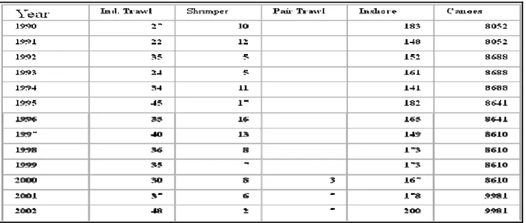
Records from the Fisheries Directorate show some increases in the number of various fleets from the early 1990s to the early 2000s (Table 6). The number of industrial trawlers almost doubled while canoes increased by about 24% over the period. The introduction of pair trawling in 2000 further increased the pressure on the stocks. In spite of the increasing fishing effort due apparently to the increasing coastal population, there has not been any significant increases in the catch rate in recent times as catches (Fig. 9) fluctuated around the MSY of 300,000 mt between 1993 and 2004 (Anon, 2003; Fisheries Directorate, 2005) while 291,000 mt was landed in 2007 (Fisheries Directorate unpubl. data).
Table 6: Changes in national fishing fleet sizes from 1990-2002
1992 1994 1996 1998 2000 2002 2004 2006
Figure 8: Fish Production in Ghana (1992-2004)
Approximately 2,400 motorized and non-motorized dugout canoes operate from 80 landing sites in the Western Region (Amador et al., 2006).
5.2.1 BY-CATCH OF ENDANGERED SPECIES
One of the crucial factors contributing to the depletion of endangered species is the by-catch and subsequent discarding of species. Except for tunas which are caught mainly by pole-lining, there are no specialized gears for catching pelagic species in Ghana, and as a result several pelagic fishes are taken as by-catches in the sardinella fishery which employs set gill nets, drift gill nets, and purse seines (Mensah and Koranteng, 1988). These fishing gears occasionally capture significant numbers of endagered species including sea turtles, seabirds, dolphins and sharks. The West Africa manatee population in the Tano/Aby/Ehy lagoon and river complex is also threatened by accidental catches in fishing nets
5.3 LOSS OF COASTAL HABITATS
There are no records on the rates of coastal habitat loss in the Region although losses have occurred over the years. Natural coastal habitats have been replaced with coconut, rubber and oil palm plantations over several years resulting in large hectares of mono- crops and thus threatening indigenous biodiversity.
Wetland reclamation for development and waste disposal has led to the loss of many lagoons and wetlands. Examples are the Esai lagoon in Sekondi, Effiakuma wetlands, and Whin River estuary and wetlands at Takoradi. Excessive harvesting of mangrove as fuel wood as fuelwood and 290,705 mt in 2007 (Fisheries Directorate) building material has affected the mangrove ecosystem along the River Ankobra estuary the Amanzule wetlands and the Whin River estuary. However, the extent of mangrove depletion in the country as a whole and the Western Region in particular is unknown (WRI, 2006).
5.4 POLLUTION OF MARINE AND COASTAL ENVIRONMENT
The threats to aquatic biodiversity in the Region come from municipal, agricultural, and industrial activities. The key sources of pollution in the Regions’s coastal Districts are waste products from coconut oil extraction, discharge of human excreta, and solid waste especially plastics into streams, wetlands and the sea. Litter entering the marine environment is known to kill sea turtles, dolphins and sea birds (UNEP, 1995). An assessment in 1994 indicated a ‘high’ domestic pollution for Sekondi-Takoradi Metropolis compared to Nzema East, Ahanta West and Jomoro (EPA, 2004). The projected pollution indices for domestic and industrial pollution (Table 7) indicate that by the year 2020 pollution in the coastal Districts would have increased severalfold from the 1994 estimates.
Table 7: Pollution indices in four coastal districts
DISTRICT Domestic
Source: World Bank/EPA (1996)
5.5 COASTAL EROSION
The Ghanaian coast is exposed to various degrees of erosion with moderate rates occurring in the Western Region (World Bank/EPA, 1996; Armah and Amlalo, 1998). Erosion at Essipon (Turtle Cove) in the former Shama Ahanta East District, Busua in Ahanta West and Axim in Nzema East District has resulted in loss of sea turtles nesting beaches. In adition fish landing sites at Princess Town, Poasi (Nkontonpo) and Essipon have been deserted as a result of severe coastal erosion (EPA, 2004).