E-mail address: [email protected] (L.I. Dimitrov).
www.elsevier.com/locate/earscirev
Mud volcanoes—the most important pathway for
degassing deeply buried sediments
Lyobomir I. Dimitrov
Institute of Oceanology, P.O. Box 152, Varna 9000, Bulgaria Received 14 March 2000; accepted 4 December 2001
Abstract
This paper discusses the nature of the phenomenon of ‘‘mud volcanism’’ with respect to degassing of deeply buried sediments. Mud volcanoes are defined as geological structures and their main elements are described. Based on the nature of activity, mud volcanoes are grouped in to three main types and the relationship between each type and corresponding mor-phological expression is discussed. The presented up-to-date data of the world geographical distribution of mud volcanoes show that they approximate to 1800 individuals. A detail overview of geological environments in which they occur helps to deduce some necessary conditions for mud volcano formation. The basic mechanisms of mud volcano formation are discussed, specifically the fluid-pressure hypothesis, and some triggering events are identified. The most common investigation approach and some criteria for recognizing of a submarine mud volcano on side-scan sonar records and seismic sections are given. Mud volcanism in the Mediterranean Ridge (an accretionary complex) and Black Sea Abyssal Plane (a back ark basin with tectonic regime of extension) are described as case studies to show variety in morphology and common factors in development of mud volcanoes. The manifestation of continuous gas migration through mud volcanoes is clarified, and the attempt made to quantify the gas release shows that mud volcanoes are one of the significant natural sources of atmospheric methane emitting a total amount of about 10.3 to 12.6 Tg annually. D 2002 Published by Elsevier Science B.V.
Keywords: Mud volcano; Clay diapirism; Black Sea; Mediterranean Ridge; Methane; Venting; Atmosphere
1. Introduction
Natural gas and oil seepage are known from many places both on land and offshore. They occur in different geological environments: on active con-tinental margins (accretionary prisms, thrust and overthrust belts and volcanic regions), passive con-tinental shelves (platforms, lagoons, deltaic
com-plexes) and open seas. They are present in oil and gas basins and have been used successfully, and still are used for predicting the presence of oil and gas fields at depth (for example: Trasher et al., 1994; Baylis et al., 1997; Traynor and Sladen, 1997). But some of the greatest seep concentrations, as well as enormous gas vents, are observed in mud volcano areas.
Mud volcanism has a long history of investigation. They have been reported since the beginning of the XVII century, but have been known for a far greater period of time, for example, they were described by
0012-8252/02/$ - see front matter D 2002 Published by Elsevier Science B.V.
Pliny in his ‘‘Naturalis Historia’’ (77 AD). Not long ago, mud volcanoes were known only on land and adjacent very shallow waters and were thought to have limited distribution (Jakubov et al., 1971; Ali-Zade et al., 1984); about 770 – 800 mud volcanoes were known. Starting from the 1970s, numerous single mud volcanoes, separated mud volcano fields and large belts have been discovered on the sea floor in waters as deep as 500 to 5000 m, in areas such as the Black Sea, Mediterranean Ridge, Nankai Trough, Barbados and other accretionary prisms, thrust belts and submarine fans. Although during the last three decades the number of publications on mud volcan-ism has significantly increased (especially papers devoted to submarine mud volcanoes due to wide use of new advanced equipment for underwater re-search), the number of mud volcanoes has remained uncertain. In this paper, an attempt is made to esti-mate the total number of mud volcanoes sum-marizing data for their world geographical distribu-tion.
The main aim of this study is to clarify the impor-tance of mud volcanoes for degassing deeply buried sediments actively ventilating overpressured Earth’s bowels. We define mud volcanoes as geological structures with variety of morphological expression, which are products of a natural process, initiated deep in the sedimentary succession, and describe their main elements. The state-of-the-art overview of environments in which mud volcanoes occur helps to deduce some necessary conditions for mud vol-cano formation as existence of fine grained, over-burden gas-charged deposits deep over 1.5 – 2 km in the section, continuous hydrocarbon generation, active tectonic regime, etc. The basic mechanisms of mud volcano formation are discussed, specifically the fluid-pressure hypothesis, and some triggering events are identified. Mud volcanism in the Medi-terranean Ridge (an accretionary complex) and Black Sea Abyssal Plane (a back ark basin with tectonic regime of extension) are described as case studies to show variety in morphology and common factors in development of mud volcanoes. The manifestation of continuous gas migration through mud volcanoes is shown and based on the made overview and esti-mated total number of mud volcanoes; an attempt is made to quantify the release of methane gas to the atmosphere.
2. Mud volcanoes—an overview
2.1. Morphological feature or natural process
Many authors describe mud volcanoes as simple topographical features complicating the surface mor-phology (Jakubov et al., 1971; Shnukov et al., 1971; Hovland et al., 1997a,b, etc.) without taking into account that these landforms are expression of a remarkable natural process initiated deep in the sedi-mentary succession.
Mud volcanoes are geological structures formed as a result of the emission of argillaceous material on the Earth’s surface or the sea floor. Sufficient water and gas is incorporated to make it semi-liquid and to force it up through long narrow openings or fissures in the crust to produce an outflowing mass of mud on the surface. The extruded material forms characteristic isometric to elongated morphological features largely varying both in shape (from elevation of plano-conical shape rising some hundred meters above the country to negative funnel-shaped forms) and size (from very large structures—up to 100 km2, to small landforms— a few tens of square meters), composed by so-called mud breccia sharply contrasting to the surrounding host sediments. These descriptions suggest that mud volcanoes are simply topographic features, however, because of their mode of formation, they are evidence of a separate natural process.
A number of papers describe the mud volcanoes as features closely related to so-called ‘‘clay or mud diapirs’’. Diapirs are domes or anterooms produced by the plastic deformations or flow of fine-grained sediments; they may deform or rupture overlying rocks. Indeed, many mud volcanoes are developed in the crests of such diapirs, but also, many of them are not connected with diapiric structures at all. However, clay diapirs most probably have the same mechanism of formation but they do not pierce totally the sediment cover, rising only to a level some way beneath the surface. If a diapir reaches the surface during its development, because of the plastic, even semi-liquid nature of the composed rocks, it has to form clay/mud outflows; consequently, it would be called a mud volcano.
Criteria by which mud volcanoes might be recog-nized include (Barber et al., 1986; Pickering et al., 1988; Orange, 1990): the shape and rock composition
9 (2002) 49-764
of the body (roughly circular or slightly elongated in plan view with broadly cylindrical form); the relation-ship to the surrounding rocks (high-angle and dis-cordant contacts with wall-rock formation; age contrast between older constituent and younger wall-rocks); the nature of the matrix and the included rocks (higher clast – matrix ratios; shape of the blocks and their relationship to the matrix; concentrating of the clast in the center of the formation); and activity events. However, there is still the question of the distinguishing of a remnant mud volcano from out-cropped mud/shale diapir, i.e. ‘‘material that has been
extruded over the ground surface from material that has been intruded diapirically and now is exposed as a result of erosion of the older enveloped rock’’ (Ridd, 1970).
2.2. Struc ture, composit ion and main elements
Despite their name, the only characteristics of mud volcanoes that link them with normal (magmatic) volcanism are the surface morphology and the vague resemblance in the activity. Indeed, sometimes they erupt violently, shooting mud and ash up to a height of a few kilometers. The emitted gases may burn to produce enormous flames. But in most time of their
life, mud volcanoes appear to be gentle, growing and expanding by massive, gradual and progressive
out-flows of semi-liquid material called mud volcano
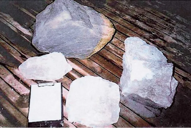
breccia (some authors used the term ‘‘diapiric mel-ange’’, Barber et al., 1986). Mud volcano breccia is composed of a mud matrix (as to 99% of the total volume), which supports a variable quantity of chaoti-cally disturbed angular to rounded rock clasts. These clasts range in diameter from a few millimeters to 10 m or more. The clasts may be of various lithological types and stratigraphical horizons (Fig. 1) and are derived from rocks through which the mud has passed on its way to the surface.
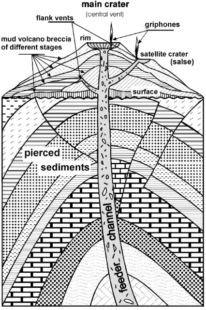
Usually, mud volcano breccia is extruded from one major funnel calledcentralorfeeder channel(Fig. 2). Near the surface, several accompanying smallerflank
or lateral pipesmay split off the feeder channel. The outcrop of the feeder channel (usually situated on the
summit of mud volcano) is called the main vent or
central crater being of varied shapes: from plano-convex or flat and bulging plateau circled by a bank to
deeply sunk rim depression—a caldera-type crater.
Calderas form when a volcano collapses because a large mass of mud volcano breccia has drained through a lower vent, or because of the expulsion of a massive amount of material in an explosive
tion. Such eruptions have been known to destroy the entire structure of a volcano. Craters associated with
the lateral vents are called satellite , pa rasite or sec-ondary crate rs (Fig. 2). Sometimes they collapse and are filled up by water that collects to form small lakes. Such a pool bubbling clay and gas is called sals es
(Fig. 3). Numerous small secondary vents called
gryphon s (Fig. 4) may form around the craters and in many places on the mud volcano body. These commonly emit gas, mud and water and are charac-terized by complete absence of solid rock fragments. Although the numerous visual observations show that the gas seeps are very common on submarine mud volcanoes (Sassen et al., 2001; Limonov et al., 1997; Foucher and De Lange, 1999; Woodside and Mascle, 1999), the migrated gas is often captured in the near bottom sediments as gas hydrate (Reed et al., 1990; Woodside et al., 1998; Ginsburg et al., 1999; Milkov,
2000) or trapped in shallow reservoirs to erupt when overpressured to form pockmarks on the seafloor (Dimitrov and Woodside, in press).
The extruded mud volcano breccia spills in rela-tively thin sheets from the craters over the landscape ‘‘in the form of broad fan-shaped or tongue-like flows up to several hundred meters wide and some kilo-meters long’’ (Jakubov et al., 1971). This builds up the body of the mud volcano, typically covering some thousands of square meters with each phase of activity, totaling up to few tens of square kilometers. The fluid behavior of the mud volcano breccia is attributed to its high water content, which on land rapidly evaporates to drain the mud over a period of several days. Slumps and slides often form on the entire structure of the mud volcanoes even in very low gradients.
2.3. Shape and size
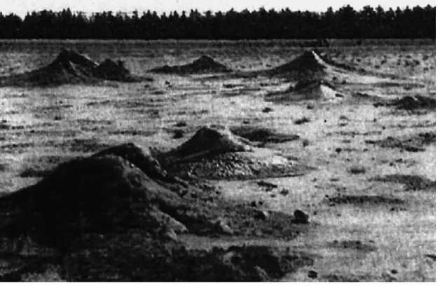
Although many of mud volcanoes have a charac-teristic form of conically shaped mountains or hills, they take on a great variety of forms referred to as ‘‘mud cones’’, ‘‘mud lumps’’, ‘‘outcrop or cratered mounds’’, ‘‘mud diapirs’’, ‘‘mud pies’’, etc., depend-ing of their shape and size. Some of them have the typical cone form, but other forms can be distin-guished: sharp cones (Fig. 11), flat and plateau cones, dome or mushroom-like shapes (Fig. 8), depressions or calderas (Fig. 9). However, most of them are com-posites, containing several craters of different shapes. The shapes and sizes of mud volcanoes depend of the degree to which mobilization has been initiated by pore-fluid pressures, the frequency and character of their activity and the viscosity of the outflowing mud. Although a variety of factors affect the relationship between them, the basic rules seem to be simple: the higher the pore-fluid pressure, the more violent the eruption; the more frequent the activity, the larger the structure; the lower the viscosity, the larger and flatter the body.
The relative heights that mud volcanoes reach vary from a few meters to 300 – 400 m, and even more than 500 m. In plain view, they are isometric or slightly elongate with craters up to 500 m in diam-eter, and 3 – 4 km across the base. Some of the mud volcanoes are spaced very close to each other, form-ing a common body and the flows of mud volcano breccia can cover areas of 100 km2or more, as they
Fig. 2. Basic structure and main elements of a conical mud volcano.
do in northern Irian Java, New Guinea (Williams et al., 1984) and the submarine Gelendzhik mud plateau in the crest of the Mediterranean Ridge (Limonov et al., 1996).
2.4. Mud volcano types
The peculiarities of the host formation and the evolution of the mud volcanoes can generally explain
Fig. 3. Three parasite craters in the Bulganak mud volcano, Kerch Peninsula, Ukraine. Two of them are collapsed and filled up by water forming small lakes—salses. The third one, situated between them, is active with well-formed cone and rimmed crater at the top filled up by semiliquid mud. (Photo: E. Kozlova).
the variety in the morphology and activity of mud volcanoes. A few classification schemes exist. They have been developed by the use of different approaches and criteria: the shape and size of mud volcano con-struction (Gubkin and Feodorov, 1940; Jakubov et al., 1971; Ivanov et al., 1996); the correlation of mud volcanoes with local geological structures-faults, type
of folding (Arhangelski, 1932), etc.
Kalinko (1964) generalized the data on numerous mud volcanoes to construct a classification system based on the character of their activity with respect to morphological expression, distinguishing three types of mud volcanoes:
2.4.1. I class —Lokbat an type
Mud volcanoes whose activity has an explosive character commonly with ignition of the emitted gases are related to this type. Short periods of activity are separated by long passive periods. Lokbatan mud vol-cano on the Apsheron Peninsula, Azerbaijan, Caspian Sea and Dzuhau-Tepe, the biggest mud volcano of the Kerch Peninsula, Ukraine, are typical examples. Usu-ally, the extruded mud breccia is characterized by low viscosity. This determines the well-formed steep con-ical shape of mud volcanoes of this type. Blockages of the feeder channel by mud ‘‘corks’’ and the explosive breaking of these corks when the pore-fluid pressure exceeds the retention force, explain the activity regime of this mud volcano type.
2.4.2. II class—C hikishlya r type
In contrast to the first class, this type is character-zed by calm, relatively weak and continuous activity. Gas is vented continuously in approximately uniform quantities. Numerous vents spit out small amounts of gassy mud and water, a very common feature of this class. This type of mud volcano is strongly affected by the presence of water saturated layers in the upper part of the sedimentary sequence. They form very low, bulged or flat domes, which merge with the surround-ing plane, or plate-shaped depressions that are often filled up with water. This type of mud volcano is very common on the Kerch Peninsula, Ukraine.
2.4.3. III class—Schu gin type
This class demonstrates a transitional type of mud volcano activity. The eruptive periods are replaced by weak activity. This type of mud volcanoes may have
the greatest distribution worldwide. It is characterized by a great variety of forms, but most commonly they build composite craters.
There is no relationship between the mud volcano types and their distribution, i.e. most commonly, all three types can be observed in any mud volcano belt, depending on the local lithological and tectonic frame-work of the host sediments.
The submarine mud volcanoes are difficult to classify but some assumptions can be made by study-ing their morphology (Ivanov et al., 1996): shape of the body, structure of the crater, mud flows, etc. The present quiescent or recent activity of submarine mud volcanoes can be judged by several peculiarities most prominent at the summit of the mud volcanoes: fluid emissions (visible as gas bubbling and water discharge or diffusive flux evidenced by instrument measure-ments only); biological and geological indicators (bac-terial mat, chemosynthetic communities, carbonate buildups, methane-derived carbonates, etc.); higher than surrounding value of the thermal field (high geo-thermal gradient); and difference of the pore-fluid of the mud breccia and sea water.
2.5. Geographical distribution of mud volcanoes
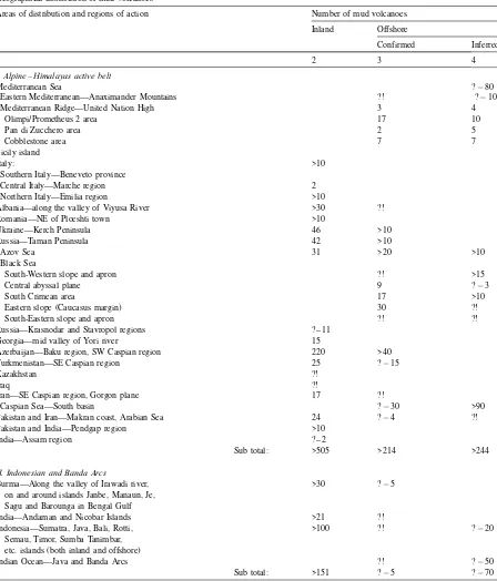
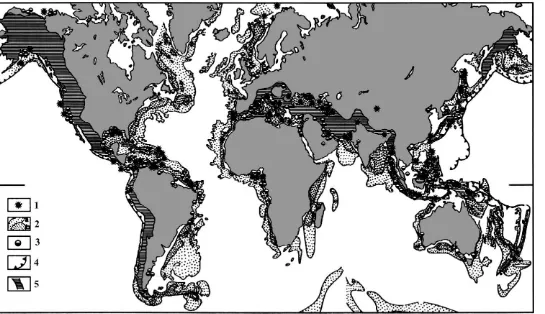
Nowadays, more than 900 terrestrial and 800 off-shore mud volcanoes are known or supposed (Table 1). They are irregularly clustered in separated areas forming belts, which almost totally coincide with active areas of the plate boundaries and zones of young orogenic structures (Fig. 5).
More than 50% of the total number of mud vol-canoes is situated along the Alpine Himalayas Active Belt. The largest and best cone-shaped mud volcanoes occur here, as well as the most active terrestrial mud volcano area with the greatest number of mud volca-noes in the world—the Baku region of the Caspian Coast, Eastern Azerbaijan. Starting from Mediterra-nean Ridge (Limonov et al., 1996) and adjacent land areas Sicily, Albania and Southern, Central and North-ern Italy (Martinelli, 1998), passing the forelands of Eastern Carpathians in Romania, Kerch and Taman Peninsulas (Arhangelski, 1932; Gubkin and Feodorov, 1940) and Great Caucasus (Gubkin and Feodorov, 1940) through the Black Sea (Ivanov et al., 1996), the belt turns to the south in the area of Southern Caspian Sea (Azerbaijan and Turkmenistan (Jakubov et al.,
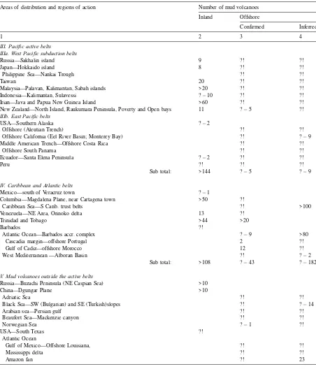
Table 1
Geographical distribution of mud volcanoesa
Areas of distribution and regions of action Number of mud volcanoes
Inland Offshore
Confirmed Inferred
1 2 3 4
I. Alpine – Himalayas active belt
Mediterranean Sea ? 80
Eastern Mediterranean—Anaximander Mountains ?! ? 10
Mediterranean Ridge—United Nation High 3 4
Olimpi/Prometheus 2 area 17 10
Pan di Zucchero area 2 5
Cobblestone area 7 7
Sicily island
Italy: >10
Southern Italy—Beneveto province
Central Italy—Marche region 2
Northern Italy—Emilia region >10
Albania—along the valley of Viyusa River >30 ?!
Romania—NE of Ploeshti town >10
Ukraine—Kerch Peninsula 46 >10
Russia—Taman Peninsula 42 >10
Azov Sea 31 >20 >10
Black Sea
South-Western slope and apron ?! >15
Central abyssal plane 9 ? 3
South Crimean area 17 >10
Eastern slope (Caucasus margin) 30 ?!
South-Eastern slope and apron ?! ?!
Russia—Krasnodar and Stavropol regions ? – 11
Georgia—mid valley of Yori river 15
Azerbaijan—Baku region, SW Caspian region 220 >40
Turkmenistan—SE Caspian region 25 ? 15
Kazakhstan ?!
Iraq ?!
Iran—SE Caspian region, Gorgon plane 17 ?!
Caspian Sea—South basin ? 30 >90
Pakistan and Iran—Makran coast, Arabian Sea 24 ? 4 ?!
Pakistan and India—Pendgap region >10
India—Assam region ? – 2
Sub total: >505 >214 >244
II. Indonesian and Banda Arcs
Burma—Along the valley of Irawadi river, on and around islands Janbe, Manaun, Je, Sagu and Barounga in Bengal Gulf
>30 ? 5
India—Andaman and Nicobar Islands >21 ?!
Indonesia—Sumatra, Java, Bali, Rotti, Semau, Timor, Sumba Tanimbar, etc. islands (both inland and offshore)
>100 ?! ? 20
Indian Ocean—Java and Banda Arcs ?! ? 50
Sub total: >151 ? 5 ? 70
Areas of distribution and regions of action Number of mud volcanoes
Inland Offshore
Confirmed Inferred
1 2 3 4
III. Pacific active belts
IIIa. West Pacific subduction belts
Russia—Sakhalin island 9 ?! ?!
Japan—Hokkaido island 8 ?! ?!
Philippine Sea—Nankai Trough ?! ?!
Taiwan 20 ?! ?!
Malaysia—Palavan, Kalimantan, Sabah islands >20 ?! ?!
Indonesia—Kalimantan, Sulavessi ? 10 ?! ?!
Irian—Java and Papua New Guinea Island >60 ?! ?!
New Zealand—North Island, Raukumara Peninsula, Poverty and Open bays 11 ? 5 ?!
IIIb. East Pacific belts
USA—Southern Alaska ? 2
Offshore (Aleutian Trench) ?! ?!
Offshore California (Eel River Basin; Monterey Bay) ?! ? 9
Middle American Trench—Offshore Costa Rica ?! ?!
Offshore South Panama ?! ?!
Ecuador—Santa Elena Peninsula ? 2 ?! ?!
Peru ?! ?! ?!
Sub total: >144 ? 5 ? 9
IV. Caribbean and Atlantic belts
Mexico—south of Veracruz town ? 1
Columbia—Magdalena Plane, near Cartagena town >50 ?!
Caribbean Sea—S Carib. trust belts ?! >100
Venezuela—NE Area, Orinoko delta 13 ?!
Trinidad and Tobago >44 >20
Barbados ?!
Atlantic Ocean—Barbados accr. complex ? 9 >80
Cascadia margin—offshore Portugal 2 ?!
Gulf of Cadiz—offshore Morocco 12 ?!
West Mediterranean —Alboran Basin ?! ? 2
Sub total: >108 ? 43 ? 182
V. Mud volcanoes outside the active belts
Russia—Buzachi Peninsula (NE Caspian Sea) >10
China—Dgungar Plane >10
Adriatic Sea ?! ?!
Black Sea—SW (Bulgarian) and SE (Turkish)slopes ?! ? 14
Arabian sea—Persian gulf ?! ?!
Beaufort Sea—Mackenzie canyon ?! ?!
Norwegian Sea ? 1 ?!
USA—South Texas ?!
Atlantic Ocean
Gulf of Mexico—Offshore Louisiana, ?! ?!
Mississippi delta ?! ?!
Amazon fan ?! 23
Table 1 (continued)
1971; Guliyiev and Feizullayev, 1997), South Caspian Basin (Ginsburg and Soloviev, 1994); and Gorgon Plain in Iran) and passing the Makran coast of Pakistan (Higgins and Saunders, 1973) and Southern Himalayas (India and China), ending in Burma. Furthermore, the Alpine – Himalayas mud volcano belt continues to the south in the most NE part of Indian Ocean on and around numerous forearc islands situated along the Indonesia and Banda Arcs (Barber et al., 1986), Indo-nesia – Australia accretion and collision complexes (Williams et al., 1984), as well as within the Banda accretionary complex offshore (Barber et al., 1986). The greatest number of mud volcanoes seems to be known on Timor Island at the southeast end of this belt. The Pacific Ocean mud volcano belts are situated along the eastern and western edges of the ocean. The western branch can be traced from Sakhalin Island (Sirik, 1968) to the north, it passes Hokkaido island, then bifurcates in southern islands of Japan circling the Philippine Sea trough Taiwan (Shih, 1967) on west, then turns to the east embracing many islands of Melanesia, then turns again to the south-west around Samoa island and ends on the North Island of New Zealand (Ridd, 1970). The greatest abundance of mud
volcanoes within this belt occurs in the New Guinea (Williams et al., 1984). Almost all mud volcanoes known of the Pacific Ocean active margins are situ-ated within its western parts and only a few mud volcanoes are known to exist on the eastern part of the Pacific Ocean: in Southern Alaska (Reitsema, 1979) and offshore in the Aleutian accretionary complex (von Huene et al., 1998), offshore California, in the subduction zones offshore Costa Rica and South Panama and on the coasts of Ecuador and Peru inland.
In contrast to the Pacific Ocean, the Atlantic mud volcano belts are located mainly in the western part of the ocean and the southern Caribbean Sea (Higgins and Saunders, 1973). Most of the terrestrial mud volcanoes are situated in the north Columbia, north-east of Uraba Bay, near the town of Cartagena, in north-eastern Venezuela, and in Trinidad (Robertson and Burke, 1989). Many mud volcanoes are found in the Barbados accretionary complex (Brown and Westbrook, 1988) and Southern Caribbean Thrust Belts, offshore north Panama and Columbia (Reed et al., 1990). Recently, mud volcanoes were discovered in the Eastern Atlantic in Cascadia margin (offshore Portugal) and Gulf of Cadiz offshore Morocco (Kenyon et al., 2000) and in Southern Canary Basin (Mu¨ler et al., 2001).
Mud volcano areas known to exist outside the above-described belts are connected with submarine deltaic and fan complexes such as Amazon fan, Mississippi and Niger (Hovland et al., 1997a,b) deltas, etc. and areas of salt diapirism such as in the Gulf of Mexico (Neurauter and Roberts, 1994), Buzachi Pen-insula—North-Eastern Caspian Sea, where they are related to salt diapirism, Alboran basin in the Western Mediterranean (Perez-Belzuz et al., 1997), etc.
2.6. Geological environments and some interrelation-ships
The geographical distribution of mud volcanoes is strongly controlled by geological environments in which they occur. Several relationships can be iden-tified. The first one is that mud volcanoes are local-ized within the compressional zones, such as accretionary complexes, thrust and overthrust belts
Areas of distribution and regions of action Number of mud volcanoes
Inland Offshore
Confirmed Inferred
1 2 3 4
V. Mud volcanoes outside the active belts
Niger delta ?! 28
Southern Canary Basin ?! ? 2
Sub total: >20 ? 1 ? 67
World total: >926 >268 >572
a
Fig. 5. World geographical distribution of mud volcanoes. 1—single mud volcanoes, separated mud volcano areas and mud volcano belts; 2—sediment thickness in the areas out of the continental shelves (modified after Boua et al., 1984): (a) from 1 to 4 km, (b) more than 4 km; 3—some of the main areas of industrial petroleum production; 4—subduction zones; 5—active compressional areas.
L.I.
Dimit
rov
/
Earth-Scien
ce
Reviews
59
(2002)
49–76
(Southern Caribbean Thrust belts, Barbados, Nankai, Banda, etc., accretionary complexes, Mediterranean Ridge, etc.), forelands of Alpine orogenic structures (Northern Italy, Romania, Kerch and Taman peninsu-las, Azerbaijan, etc.), as well as zones of dipping noncompensating sedimentary basins (Black Sea and South Caspian basins), which coincide with the active
plate boundaries (Fig. 5). The few mud volcano areas out of these belts are attached to zones with high rates of recent sedimentation, such as modern fans (includ-ing underwater deltas of large rivers) or intensive development of salt diapirism.
The second relationship is that there have to exist a potential source layers deep in the sedimentary suc-cession. Usually this will be composed of fine-grained, soft material of low density overlain by at least 1 – 1.5 km of denser sediments (Fig. 5). All collision com-plexes where mud volcanoes are abundant are charac-terized by thick sediment sequences caused by thickening of accreted sediments (more than 3 km in the Timor Accretionary complex and Southern Car-ibbean Thrust belts, and more than 5 km in the Barbados Accretionary complex, etc.). The same is valid for forearc and outer orogenic basins where thickening is caused by thrusting and overthrusting (over 7 km in the New Guinea, forelands of the Carpathians and Great Caucasus, including the Kerch and Taman peninsulas, the Krasnodar region, etc.). Enormous thickness is established in the
noncompen-sating sedimentary basins, such as the Black Sea and South Caspian basins with sedimentary sequences more than 15- and 25-km thick, respectively. In all the mud volcano areas, there are suitable ‘‘source’’ layers of muddy sediments in the deeper part of the sedimentary basins or in the vicinity of the decole-ments in the accretionary complexes. In the Black Sea – Caspian Sea mud volcano belt this is in the Maikopian (Oligocene – Lower Miocene) Formation (Ivanov et al., 1996); the Bobonaro Scaly Clay (Plio-cene deep-water sediments) in the Banda Arc (Barber et al., 1984); the sediments of deep-sea fan complex of the Orinoco River (mid-Oligocene – Miocene) in the Eastern Venezuela and Trinidad (Robertson and Burke, 1989), Dannevirke – Arnold Series (Paleo-cene – Eo(Paleo-cene) Raukumara Peninsula, New Zealand (Ridd, 1970), etc.
The comparison of the maps of world mud volcano distribution and industrial oil and gas concentrations
(Fig. 5) suggests a third relationship, namely, that mud volcanoes are situated in areas where hydrocarbons have been, or are, actively being generated. This relationship was established a long time ago. On the Apsheron Peninsula, Caspian Sea, near the natural mud volcano gas seeps above the Surahan oil – gas field; there still is preserved a temple of the fire worshippers that was built by the Indians in the XVII century. At the beginning of the present century, numerous boreholes were drilled around single mud volcanoes in Azerbai-jan, Krasnodar and many other terrestrial mud volcano regions all over the world and many petroleum discov-eries were made. The importance of petroleum geology is principally that the surrounding facies, below and laterally adjacent to mud volcanoes, may be particu-larly favorable as both reservoir and source environ-ments, very often resulting in multilevel fields. Al-though this relationship is not valid for many mud volcano areas, for modern accretionary complexes in particular, it is established that present-day or recently active oil and especially gas generation are character-istic features for all of them.
Summarizing these brief comments the occurrence of mud volcanoes is strongly controlled by:
recent tectonic activity, particularly
compres-sional activity;
sedimentary or tectonic loading due to rapid
sedimentation, accreting or overthrusting;
continuous active hydrocarbon generation;
the existence of thick, fine-grained, soft, plastic sediments deep in the sedimentary succession.
2.7. The basic mechanism of mud volcano formation
The above-mentioned controlling factors are rigidly required conditions for mud volcano formation, but they do not explain how mud volcanoes are formed. What is the driving force, which makes the deeply buried clays to rise up to the surface, that pierce a thick sedimentary cover?
Nowadays, it is believed that this is the main driving force for mud volcano formation.
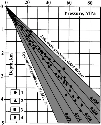
How is a high pore-fluid pressure formed? In an active tectonic setting of folding, accreting and over-thrusting sedimentation rates are very high; the accu-mulation of predominantly terrigeneous rock with a prevalence of shale, and its fast covering by denser sediments, is the first factor. Secondly, the fast burial of this material results in them being undercompacted. The retention of a high proportion of the initial water content (20 – 40% absolute water content has been measured in mud volcano breccia—Foucher and Henry, 1996) and the weight of overburden leads to an increase in the pore-fluid pressure, so such bodies become undercompacted and overpressured relative to the surrounding sediments. At the same time, this material is highly enriched with organic matter. Post-depositional transformation leads to active biogenic and thermogenic gas generation: ‘‘which is an impor-tant added factor which tends to accentuate, or even create, their overpressured, undercompacted state, both by building up additional internal pressure, and also by impeding fluid expulsion because of the development of a second phase in the pore fluid’’ (Hedberg, 1974). The high pore-fluid pressure is a characteristic feature of all mud volcano areas (Kalinko, 1964; Hedberg, 1974; Ozernii, 1981; Reed et al., 1990; Williams et al., 1984) and may exceed more then twice the hydrostat-ic pressure (Fig. 6) and even to be greater than the weight of overburden. In some regions, such as in Baku area of Azerbaijan, the pressure is so high that exploration and production drilling has not been pos-sible. The high water and gas content dramatically decreases the bulk density, shear modules and viscos-ity, making such sediments semi-liquid and able to flow. Such a sequence of low density, undercompacted overpressured muds or shales overlain by thick denser material, is mechanically unstable and frequently finds expression in mud or shale diapirs or in mud volca-noes.
An important additional factor in creating high-pore fluid pressure is the tectonic forces of compres-sion. Such forces are a characteristic feature for all plate collision zones and fold-thrust-overthrust belts where mud volcanoes are abundant. In the areas where compressional forces are week or absent, it is observed a process of pressure transmission from deep parts of synclines to the shallowest parts of anticlines
by squeezing out of the plastic material and fluid migration within the folded regions, such as Indolo-Kuban (Kerch and Taman peninsulas, Ukraine and Russia) and South Caspian basins, etc.
Hovland and Judd (1988) proposed an attractive model for large-scale mud diapirism in the Gulf of Mexico where salt domes are very common features. Salt domes provide pathways for continuous migra-tion of hydrocarbons and low-density liquids, which are trapped inside the plastic mud above the salt. As the gas rises it expands, increasing the pore pressure and helping to buoy up and mobilize the mud. Com-plicating the model, suppose that the salt dome is still mobile and is rising; in this case it will produce ten-sional conditions near the surface, resulting in normal tensional faults. At the same time, the mud layer, loaded by thick coarse sediments and situated just above the salt, will be under compression and its pore-fluid pressure will increase with the upward move-ment of the salt dome. A pathway for lowering the
Fig. 6. Diagram of the pore-fluid pressures in the Indolo-Kuban Basin (Kerch and Taman peninsulas). Pressure within sediments of: 1—Miocene; 2—Maikopian (Oligocene – Lower Miocene); 3— Eocene – Paleocene; 4 — Cretaceous and Jurassic age. (after Ozernii, 1981).
continuously increasing pressure is to be found in the tensional faults.
Other processes of minor importance acting in combination with the main processes mentioned above to create high pore-fluid pressure are (Fertl and Chilingarian, 1987): diagenetic phenomena (de-hydration of expandable clays through mineralogical transformation (Barber et al., 1986); secondary pre-cipitation of cementing materials (creating sealing barriers and/or decreasing pore space); thermodynamic effects; and biochemical effects (two- to threefold volume increase caused by breakdown of hydrocarbon
molecules).
So, it may be considered that the main driving forces for mud volcano and mud diapirism formation are:
internal buoyancy forces caused by density
inversion of light, gasified, buoyant, plastic clays beneath a denser overburden.
high pore-fluid pressure, provided by expanding,
gases trapped inside the plastic clays and other internal processes;
structurally or tectonically induced high
pore-fluid pressure.
What are the triggering events for mud volcano formation? Firstly, mud volcanoes might be self-induced features; when the pore-fluid pressure exceeds the internal forces or lithostatic pressure, vertical hydraulic fracturing may occur. As was previously pointed out, mud volcano belts are situated at active plate boundaries for which two characteristic features are common: a compressional tectonic setting and high levels of seismicity. On one hand, tectonic compres-sion would contribute by increasing the pore-fluid pressure and by creating faults, weakened zones along which the semi-liquid material can migrate. On the other hand, seismic activity also leads to the formation of numerous faults, but the earthquake acts, not only forming suitable pathways to the surface, but also it breaks the established fragile metastable conditions of the overpressured mud or shale, initiating their move-ment. Regional extension also may act as a trigger for mud volcano formation by weakening the overburden by fracturing and thinning it (Jackson and Vendeville, 1994). Moreover, because of the semi-liquid nature of mud breccia its behavior can be provoked by Moon or
Sun gravity (just like tides) and mud volcanoes may erupt or increase activity according to their position (Guliyiev and Feizullayev, 1997).
So, the following triggering events can be identi-fied:
hydro fracturing caused by pore-fluid pressure
exceeded the internal forces or lithostatic pressure;
tectonic stress or extension resulting in fault
generation;
seismic activity.
3. Case studies
A number of international research projects for investigation of deep sea sedimentary basins in the Atlantic Ocean, Mediterranean and Black Seas have been supported since 1991 by the UNESCO/IOC-ESF scheme called ‘Training Through Research’ (TTR). A great number of new mud volcanoes have been dis-covered during already eleven TTR Cruises in the Black and Mediterranean Seas and East North Atlan-tic and many of them were studied in detail. The gained experience resulted in an applied methodology very helpful in studying mud volcanoes in deep marine environments.
4. Identification of submarine mud volcanoes
4.1. Investigation approach and equipment
A combination of different approaches and inves-tigation methods are used, supported by a range of re-search systems, for discovering and identifying sub-marine mud volcanoes. Usually, as with most scientific works at sea, three main stages can be distinguished: regional or searching stages, local or detailed survey and sampling.
for more detailed observations. Deeply towed high-resolution sonar and profiler systems are used during the second stage for creating a detailed image of the sea floor topography and seabed sediment lithology, as well as the thickness and stratification of the topmost subbottom sediments. Finally, the identified structures are sampled at selected points by gravity corers, grabs, etc. for a range of geological and geochemical analysis. TV, photo and/or visual observation from ROV or submarines are also used if available. Either of the first two stages can be modified using different survey equipment combinations (adding gravity and/or mag-netic field measuring for example). Precise positioning of both onboard (satellite navigation GPS NAVSTAR system is good one) and underwater (any hydroacous-tic navigation system) devices is a strong requirement for successive investigations.
If regional data for the study area already exist from previous investigations, the first stage can be reduced to a minimum or completely ignored. Limonov et al. (1996) have used this approach in the Eastern
Medi-terranean Sea. Reviewing GLORIA sonograms ob-tained in 1977 and 1979, they pointed out a number of possible single mud volcanoes and mud volcano areas. These were proved by the recent findings (Li-monov et al., 1996).
The discovery of a new mud volcano can be con-firmed if the data acquired by each method applied agree, showing: an isometric or slightly elongated high backscattering, positive topographic feature on the sonograms; a dome, cone or isolated rimmed depres-sion on the sea floor with characteristic inner structure,
which differs to the surrounding layers on the seismic and profiler records; and finally, the occurrence at or below the surface of mud breccia, strongly contrasting in lithology to the host sediments, in the cores taken on this structure.
4.2. Appearanc e of mud volcan oes on sonogr ams
Mud volcanoes are prominent topographic fea-tures; highs or rimmed depressions and will give a characteristic backscatter patterns on the sonograms. The texture of the floor also affects the strength of the echoes. A flat smooth sea floor composed of uniform sediment appears as the same tone of gray or black, slightly lightening with increasing of the distance from the towfish. Mud and sand will tend to cause
little backscattering towards the towfish but shells, gravel and coarser sediments will send back much more of the incident sound. However, mud volcano breccia is much more coarse than the surrounding very fine-grain pelagic or hemipelagic sediments. So it is displayed as a dark patches among the light phone on the sonograms (see (Figs. 8, 9, 11 and 12)) even if is covered by younger sediments of a meter or more. In addition, mud flows of different generations and connected with certain stages of mud volcanic activity can be distinguished with sufficient precision. Old mud flows of a mud volcano should have a smoother surface as a result of erosion caused by submarine currents. Also, the older the flow, the thicker the overlaying pelagic sediments should be. Each of these reasons or both of them together, may result in older flows having lower backscattering.
4.3. Seismic characteristics of mud volcanoes
A mud volcano is easy recognizable feature on seismic records in the well stratified sedimentary sequence, as in the Black Sea Abyssal Plain (Figs. 8 and 9), but they are identified with difficulty in accretionary and overthrust complexes. Firstly, seis-mic records have to be inspected for characteristic isolated sea floor forms—cones, domes, rimmed depressions or depressions. Secondly, the sub-seabed structure of these forms must be checked for: is there a generally vertical, narrow zone lacking reflections or of chaotically disrupted, short reflections, connected with the sea floor topography? (the sediments filling the feeder channel are not stratified and do not give any reflections); is there a ‘‘pull down’’ effect of the reflections adjacent to the feeder channel? (the mud volcano breccia is characterized by lower sound velocity than the host sediments); are there extraordi-nary reflections beneath the sea floor feature such as increasing intensity (interference effect), or steep hyperbolic patterns caused by diffraction?; are there gas associated features around the feeder channel, such as ‘‘bright spots’’, acoustic turbidity, etc.?
All these peculiarities together with other available geophysical and geological data aid the identification of submarine mud volcanoes.
Using the above approaches mud volcanoes were discovered in the Abyssal Plain, Sorokin Trough, Caucasus and Georgia margins of the Black Sea
(TTR’1,2,3,6 and 11), all mud volcano areas in the Mediterranean Ridge and Alboran Sea (TTR’3,4,5,9 and 11) and North Eastern Atlantic (TTR’7,8,9) and many of them confirmed by sampling or visual observation and named according the tradition. The following description of the Black and Mediterranean Seas mud volcanoes is based on the data obtained during TTR Cruises, particularly those of the 5th TTR cruise in 1995 in which the author have pleasure to participate.
4.4. Blac k Sea Abyssal Plane
The presence of mud volcanoes in the central Black Sea Abyssal Plane has been suspected from the end of 1970s, when a set of multi-channel seismic data was obtained by ‘‘Yuzhmorgeologiya Enter-prise’’—Gelendzhik, Russia. From 1988 to 1994, several UNESCO-ESF expeditions were carried out
in this area and nine mud volcanoes were studied in detail.
The Black Sea mud volcanoes are randomly dis-tributed at water depths below 2 km in an area of 6500
km2 south of the Crimean Peninsula (Fig. 7). The
central part of the Black Sea where mud volcanoes are situated structurally belongs to the West Black Sea sub-basin. It is underlain by sub-oceanic (basaltic) crust and contains a sedimentary basin fill of up to 15-km thick. These sediments include about 6 km of Paleocene – Eocene deposits, more than 5 km of Mai-kopian Formation (Oligocene – Lower Miocene) and about 2.5 km of Plio – Quaternary sediments. The sedimentary layers are almost horizontal in the greater part of the Black Sea Basin, but in the mud volcano area they are locally influenced by very gentle folds and low-amplitude flexures and normal faults. The faults have a vertical offset of 20 – 30 m and develop a depth of greater than 400 – 500 m below the sea floor.
Tectonically they imply a tensional regime in the area (Ivanov et al., 1996).
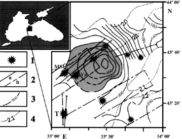
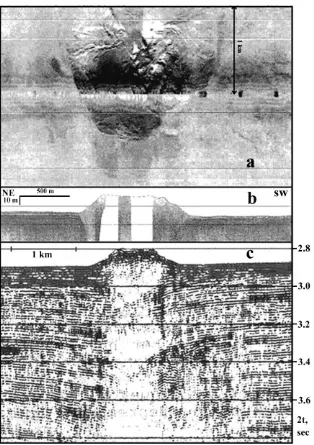
The seven of the ninth mud volcanoes generally have a mushroom or cone-like shape and rise 20 – 150 m above the surrounding flat sea floor. They are isometric features in plan view with diameters at the seabed varying from 1 to about 3 km. The largest mud volcanoes, ‘‘Yuzhmor-geologiya’’ and ‘‘MSU’’, are gentle structures with complex craters and well-defined rim. They have seabed diameters of more than 2.5 km and relative height of 100 – 150 m. It can be distinguished at least three generations of massive, superimposed mud flows on the flanks of both mud volcanoes on the high-resolution MAK-1 side-scan sonar records as well as two younger craters, about 500 and 300 m in diameter, within the main and older crater of the ‘‘MSU’’ volcano, which suggest several stages of strong eruptions. There are also some small circular features, which most probably represent local gas vents and seeps. Both mud volcanoes may have developed over a long time and, presently, they appear to be in a quiescent stage of development as well as entire of them. Other mud volcanoes with positive structures are smaller (diameter at the base from 1 to 1.8 km and height of 50 – 80 m), with relatively steep flanks and many radial channeled mud flows on them (Fig. 8), which may indicate a relatively young age. The ‘‘TREDMAR’’ mud volcano has a very complex structure (Fig. 9): its north – northwestern part is crater-like, forming a depression of 40 m below the surrounding sea floor, whilst the south – south-eastern side represent a hummocky hill with extensive mud-flows patches. This mud volcano and probably the ‘‘Vassoevich’’ (mud volcano with a supposed collapse structure) are believed to be the youngest and active today (Ivanov et al., 1996).
The usually clearly identifiable by lack of regular reflections feeder channel of all mud volcanoes on the seismic records (Figs. 8 and 9) can be traced up to 7 km down in the sedimentary sequence. Numerous ‘‘bright spots’’ are adjacent or occur close around the channels from 200 to 900 ms two-way-travel-time (TWTT) below the seabed, which clearly indicate multilevel gas presence. Evidence for the occurrence of gas seepage, gas hydrate and gas-charged sediments was found within the craters and on the slopes of most of the mud volcanoes. The gas is composed domi-nantly by methane (90 – 99%) and is of mixed biogenic
and thermogenic origin (Ivanov et al., 1997). The highly gas and fluid saturated mud breccia (so-called ‘‘mousse’’, Limonov, 1994) of all Black Sea mud vol-canoes is a characteristic feature distinguishing them from those in the Mediterranean Ridge.
Sampling of the mud volcano breccia showed that the older sediments are of Maikopian age, which, together with seismic data, suggest that most probably the ‘‘roots’’ of mud volcanoes are in the thick, fine-grained sediments with considerable hydrocarbon po-tential of the Maikopian Formation.
Formation of the Black Sea Abyssal Plane mud volcanoes is controlled by following conditions: the high sedimentation rate of the Plio – Quaternary depos-its leading to fast burial of the sediments; the presence of thick, heavy overburden and plastic Maikopian clays, which makes them an excellent impermeable cap rock for fluids; the sediments of the Maikopian Formation are highly enriched with organic matter and so with great potential to generate hydrocarbons (the older sediments may have the same hydrocarbon potential), which leads to overpressure; and the pres-ence of small-amplitude normal faults creating weak-ened permeable zones in the overlying sedimentary sequence.
Thus, the origin of the Black Sea mud volcanoes is strongly related to hydrocarbon generation and a high sedimentation rate, but there still is a question: why exactly in this area of the Black Sea Abyssal Plane? The Maikopian Formation spreads with appropriate thick-ness and surrounded environment to produce a mud volcano embracing almost whole deep Black Sea basin (Muratov, 1972) and other areas where mud volcanoes do exist as Kerch, Taman and Caucus continental slopes and aprons. An explanation could be the devel-opment of an ophiolite structure here raised a few kilometers from the basalt crust (Finetti et al., 1988) clearly identified by magnetic field (Fig. 7). This bulge acts similar to salt diapir bringing the top of the Maikopian clays close to the seafloor, forcing their overpressure and creating tensional faults above them.
4.5. Mediterranean Ridge
The chronicle of the discovery of mud volcanoes on the Mediterranean Ridge at the end of 1970s and their further investigation is well documented (Ivanov
et al., 1996; Limonov et al., 1996; Fusi and Kenyon, 1996, etc.) it only should be noted that the annexed
methodology have been widely applied.
The Mediterranean Ridge, the most prominent sub-marine relief of the Eastern Mediterranean, stretches from the Levantine Basin in the northwest to the
Cyprus Ark in the east, a distance of about 1500 km with a width from about 150 to 300 km (Fig. 10a). It has an arcuate southward convex shape, almost parallel to the Hellenic Arc and has an average water depth of about 2.1 – 2.2 km, varying between 1.2 and 3.0 km. Small, closely spaced depressions and ridges, with a
relief of 50 – 100 m and wavelength of 0.5 – 2 km, mostly parallel to the Ridge trend, generally dominate the Ridge topography. This relief creates hummocky
hyperbolic acoustic reflections when using conven-tional echo-sounding and seismic devices widely known as ‘‘cobblestone topography’’.
Fig. 9. The TREDMAR mud volcano (description as on Fig. 8) (modified after Limonov, 1994). The ‘‘pull-down’’ effect of well-stratified horizontal reflections is clearly seen at the edges of the feeder channel on the seismic section, caused by decreasing of sound velocity in the gas-saturated mud breccia.
At present, the Mediterranean Ridge is considered to be Neogene to Recent accretionary prism buildups by offscarping and pilling of the upper part of the sedi-ments deposited on the top of the downgoing African plate. The sediment cover and probably the basement are intensively disturbed by compressional deforma-tion: folds, reverse faults, thrust, and strike-slip faults (Ivanov et al., 1996). Because of this intense faulting, in addition to the ‘‘cobblestone topography’’, the
sedi-ment cover of the Mediterranean Ridge is very poorly expressed on the seismic records. These hardly affect also the deep structure of the Mediterranean mud volcanoes, which differentiate them from those in the Black Sea Abyssal Plain to which feeder channel is usually vertically well delineated.
It is thought that the sedimentary cover of the Ridge is composed of about 200 to 700 m of Plio – Quater-nary hemipelagic and turbiditic deposits, over 1 km of
the Messinian evaporates, and several kilometers of pre-Messinian Tertiary and Cretaceous sediments of unknown lithology. On the elevated portions of the Ridge, the Messinian layer is significantly thinner than on its deeper flanks (along the outer and inner defor-mation fronts), and is missing in some crestal regions
(Limonov et al., 1996).
Nowadays, about 30 exposed mud volcanoes checked by coring are known within the Mediterranean Ridge, and it is thought that there are more than 100 (Fig. 10a). Most of them are situated in the crestal part
of the Ridge and are generally clustered in elongate groups forming a linear zone related to the principal thrust plane. As it appears that the discrete areas of mud diapirism belong to a continuous chain, Limonov et al. 1996) define it as ‘‘The Mediterranean Ridge Mud Diapiric Belt’’.
The known mud volcanoes are clustered in several areas (Fig. 10): the Cobblestone area;
Olimpi/Prom-etheus 2; Pan di Zucchero; and United Nation Rise areas. They are much more diverse both morphologi-cally and in respect to activity (Ivanov et al., 1996 distinguished six types of mud volcanoes) in compar-ison with the Black Sea ones and have more complex structures, which directly reflects the age and duration of their development and mode of their formation.
A bright characteristic of the Mediterranean Ridge Mud Diapiric Belt is that recently active mud vol-canoes are situated in neighborhood to inactive ones even to extinct structures buried below a cover of young deposits with different thickness. This suggests that the development of the mud volcanoes is an on-going process continued through geological time of accreting.
Buried mud volcanoes are usually circular features with diameter of 2 – 2.5 km (Fig. 11) and most probably are remnants of craters of large, now inactive and extinct mud volcanoes. Hemipelagic sediments
Fig. 11. MAK-1 record across a buried mud volcano in the Cobblestone area (modified after Ivanov et al., 1996). Note the lower backscattering of the structure compared with other mud volcanoes that are more recent and exposed on the seafloor mud breccia, the nearly circular shape of the crater and its well-formed rim.
bury them with thickness from 2 – 5 to 20 – 30 m, suggesting that they could be of different age. The volcano rims rise 15 – 30 m above the surrounding sea floor and mud flows usually are not seen (Fig. 11). Within some craters of these mud volcanoes, secon-dary, younger vents of 100 – 150 m in diameter occur (Ivanov et al., 1996).
Another prominent feature is that the largest and most complicated mud structures of the currently known mud volcanoes are localized here: the
Maid-stone, the Moscow and the Gelendzhik mud plateaus. They are asymmetric in cross section and have diameters at the base of about 7 – 10 km and rise more than 200 m. These could be either single giant mud volcanoes or a group of tightly grouped struc-tures (Ivanov et al., 1996). The tops and flanks of these mud volcanoes have a complex hilly relief due to the overlapping of mud flows of different gener-ations.
Well-expressed mud volcanoes with regular cone or dome shapes and well-defined craters of 100 – 200 m in diameter (Fig. 12) are probably the most common
features in the Mediterranean Ridge Mud Diapiric Belt. They are isometric in plan view with seabed diameters varying from 2.0 – 2.5 to about 4.5 km and 50 – 120 m in high. Their flanks are covered entirely by mud flows, which have poured out of the central craters (Ivanov et al., 1996). The Novorossiysk (Fig. 12) and Aros (Cobblestone area), Toronto, Napoli and Milano (Olimpi/Prometheus 2 area) and Stoke-on-Trent and Dublin (United Nation Rise) mud volcanoes are typical examples. In 1995, during the Leg 160 of ODP Program, nine boreholes were drilled in the Milano and Napoli mud domes. The results confirmed the mud volcano origin of these structures penetrated more than 200 m of mud volcano breccia of middle – early Pliocene to late Pleistocene age. Most of these mud volcanoes exhibit active gas venting and seeps within the craters. Indirect evidence related to fluid escape such as pockmarks and bacterial colonies has been observed also.
Nowadays, it is considered that the principal mech-anism responsible for the formation of the Med-iterranean Ridge mud volcanoes is lateral tectonic
compression. ‘‘The strong lateral compression creates a stacking of sedimentary strata with different lithol-ogies and densities which are in contact along thrust planes. Where less dense plastic sediments, under-consolidated and especially gas-charged sediments are overlain by denser rocks, the plastic sediments are pressed up and search for their way upward along the fault planes. Because the fault planes may intersect in different directions and may have a variety of dips, even in contrasting directions, the feeder channel might be of an extremely complex form’’ (Limonov et al., 1996). It is also suggested that Messinian evaporates are an important factor controlling the mud volcano distribution. They usually occur where evaporates are very thin or missing all together (Limo-nov et al., 1996).
5. Mud volcano es—a source of atmosp heric methane
5.1. Compos ition of the emitt ed gases
As has been shown, gases play a significant role in the formation of mud volcanoes and their post-for-mation activity. The gases come mainly from source rocks and muddy sediments (clays, shales, mudstones, siltstones and marls), but shallower layers through which the mud breccia passes may also contribute to gas. It is known that organic matter makes up a substantial part of freshly deposited muds. During post-depositional history, ‘‘as a complex of biochem-ical processes breakdown the organic matter, the so-called biochemical gases are generated: nitrogen – methane, methane, and carbon dioxide – methane in composition. They are characterized by a very large amount of methane (up to 99%) and quite a small or practically zero amount of methane homologs’’ (Hed-berg, 1974). The biochemical gases occur both under surface conditions (Allen et al., 1969; Friedman et al., 1971) and at depths up to 1200 – 2000 m. Usually the roots of mud volcanoes lay below these depths and it can be expected that these gases or organic matter will be reworked thermogenically, producing the so-called ‘‘thermogenic’’ gas.
Indeed, the gases detected venting from mud vol-canoes are composed dominantly of methane although some mud volcanoes emit carbon dioxide- or
nitrogen-enriched gases (Fig. 13). Some of the gases contain dry biogenic methane, others heavier, thermogenic meth-ane. Usually, the gases of thermogenic origin contain methane accompanied by small amounts of methane homologs as well as oil leakage. This is characteristic of mud volcanoes from oil and gas basins such as in Azerbaijan, Romania, Mexico, Columbia, etc.
5.2. Contribution to atmospheric methane
Mud volcanoes provide an extremely fast-rising stream of gas to the surface, even during periods of quiescence; these exceed by a few times the conducting capability of an open fracture fault system.Depending on the activity of the mud volcanoes, they sporadically or continuously emit considerable volumes of gas to the atmosphere. Huge amounts of gas are ejected during the eruptive phase of mud volcano activity, forming 60 – 80 % of the total budget of the emitted gas. This is suggested by reports of the characteristic noise asso-ciated with mud volcanism and by the enormous flames observed. For example: on 5th January, 1887, the eruption of the Lokbatan mud volcano in the Baku region produced a flame reaching a height of 600 m and more; the eruption of Erin (southern coast of Trinidad) on 4th November, 1911, produced a flame about 100-m high, which burned for 15.5 h; in October, 1976, methane gas from La Lorenza mud volcano (Colombia) ‘‘ignited with a flame 100-m high and burned for several days, destroying houses and trees up to 8 km away’’ (Hedberg, 1980), etc.
This applies not only for terrestrial but also for sub-marine mud volcanoes. For example: a large (about 1.5 km) and high (about 500 m) flame was documented in the Black Sea approximate 5 nautical miles from the coast by the Navy Observation Station near the town of Feodosia on the Kerch Peninsula on 12th September, 1927. The event took place immediately after the Crimean earthquake of magnitude VII MSK at 2:48 am and is supposed to be an eruption of mud volcano. Similar flames also have been observed in the Caspian Sea, offshore Apsheron peninsula (Sokolov et al., 1969).
The energy potential of the degassing process through mud volcanoes can be judged by the enor-mous volumes of rock material extruded during
erup-tions. These can exceed 1,500,000 m3 (for example
the estimation of 100,000 tons of viscous mud
truded from the Waimata Valley volcano, Timor Island in less than 1 h—Barber et al., 1984).
Gas venting continues through periods of quies-cence when negligible amounts or no mud is expelled. The volumes vary over a very large range even over short time periods—from negligible to 40,000 m3per day. Moreover, diffuse fluid flow through sediments surrounding mud volcanoes may results in fluid fluxes even larger than those channeled through mud volca-noes.
Despite the significance of mud volcanoes as an atmospheric methane source, no realistic estimate of global production is possible at present. However, the figures presented in the Table 2. suggest that mud volcanoes represent a sizeable source.
Although the estimates vary, they do not differ dramatically. If the data from these examples are extrapolated to provide an annual rate of emitted gas for an ‘‘average’’ single mud volcano, it can be seen
that the values vary from 0.3 to 2.4 Gg CH4year 1
during the quiescent periods. An annual input to the
atmosphere may be estimated by multiplying these values by the total number of inland mud volcanoes and those situated in the adjacent very shallow water areas, because of almost total solution of the gas bubbles from gas seeps situated deeper than 75-m water depth (Judd et al., 1997). The diffusive flux and low intensity gas venting from mud volcanoes in deep water environments are not taken into account also because gas is partially converted into hydrate (as much as 10%—Ginsburg et al., 1999), partially con-sumed by bacteria or oxidized in the near bottom sediments; other parts are captured in a hydrate form directly on the seafloor (MacDonald et al., 1994) or consumed by diversity of species in a chemosynthetic communities (Sassen et al., 1994, Sassen et al., 1999), and the amount of the gases left dissolve totally in the sea water. In this case, the estimated 1100 individual mud volcanoes would produce between 0.33 and 2.64 Tg CH4year 1.
The volumes of gas released during the eruptive periods of mud volcano activity are more difficult to
estimate. To do this, three parameters have to be known: the total number of mud volcanoes character-ized by explosive activity (the first and third classes); the frequency of the eruptions for each mud volcano; and the quantities of gas emitted during each eruption. Such statistics are not available even for inland mud volcanoes and almost impossible for submarine ones. This is for many reasons: difficulties in their classifi-cation, distance from observation stations, etc.
How-ever, some episodic data on the subject are published. Thus, for example, Sirik (1968) described 11 eruptions of the Pugachev mud volcano for the time period from 1906 to 1961, and 3 eruptions of the Southern Sakhalin one from 1933 to 1961, both on Sakhalin Island. Des-pite the irregularities of the eruptions, a time interval of 5 – 7 and 11 – 14 years may be assumed between each eruptive phase for the Pugachev and Southern Sakhalin mud volcano, respectively. Jakubov et al. (1971)
pro-Table 2
Existing estimates of methane emissions from mud volcanoes
Author(s) Estimates, Tg CH4 Author’s description
Calm period Eruptive phase
Sokolov et al. (1969) 0.00026 – 0.0008*1 0.15 – 0.36**2 (1) ‘‘1 – 3000 m3
or more in a day’’
(2) ‘‘some hundred million of m3in 1 – 2 days’’ 0.21**3 (3) ‘‘300 million m3
from m.v. of the bank of Makarov during eruption on 15 Nov. 1958.’’
0.061*4total (4) ‘‘105
Tg CH4has been emitted during the Quaternary Period’’—for m.v. of Baku region
Jakubov et al. (1971) 0.01*1 (1) ‘‘40,000 m3
daily from the Dashgil m.v.’’
0.0004*2 0.18**4 (2) ‘‘1500 m3
daily from the Nabur m.v.’’
0.014*3 (3) ‘‘20 million m3on the average are emitted
during quiescence from m.v. of Azerbaijan’’
0.2* total (4) ‘‘250 million m3on the average are emitted
as result of eruptions from m.v. of Azerbaijan’’
Zorkin et al. (1982) 0.36* 0.25**1 (1) ‘‘9
109m3over periods of days’’
0.07*2 (2) ‘‘gas seeps in m.v. area not directly connected
with them’’
Kudryavtzev (1984)*** 0.36 – 0.72 up to 28.68**1 (1) ‘‘from 0.5 – 1.0 to 20 – 40 billions m3’’
Geodekyan (1984)*** 0.15*1 0.07 – 0.36** (1) ‘‘20
1012m3for one million years of South Caspian m.v. area’’
0.02 – 0.16*2total (2) ‘‘52 – 370
1012m3both in calm and eruptive phases during the Quaternary Period’’ Dadashev (1984)*** 0.14*1 0.015 – 0.36** (1) ‘‘from m.v. of Eastern Azerbaijan’’
Plotnikov (1984)*** 0.05*1 (1) from m.v. of Kerch peninsula—26 (?!)
Guliev and Feizullayev (1994) 0.014*1 0.22*1total (1) ‘‘annual production of hydrocarbon gases on the territory (Azerbaijan) by m.v. amounts 3108m3. . .’’ Hovland et al. (1997a,b) 0.000004*1 (1) visible ‘‘ bubble’’ flux during the calm stage
of the Dashgil m.v.—Azerbaijan Foucher and Henry (1996) 0.003*1, 0.00032* —
from two m.v. seaward of Barbados
(1) ‘‘from dissociation of gas hydrates, 8000 kg of methane could be released per day by the Atalante m.v. alone’’
Valyaev (1998) 0.125**1 (1) ‘‘175 trillion m3over the past million years
from 220 m.v. of Azerbaijan’’
Glebov and Shelting (1998) from 0.00011 to 0.00052*1 (1) ‘‘from 350 – 520 to 1500 – 2000 m3per day during periods of quiescence’’
Ginsburg et al. (1999) from 0.00009 to 0.0001*1 (1) ‘‘total amount of methane transported by the HMMV into the seawater during the time of his existence is about 1.5109m3(for 12 ka) or 31010m3(for 200 ka)’’— calm flow *: Annual rates.
**: Per one eruptive phase.
***: Data are quoted in Ali-Zade et al. (1984).
vide statistic for 32 mud volcanoes from Eastern Aze-baijan region, considering that ‘‘122 eruptions have occurred from 1840 to 1967’’, which suggests average time periods varying from about 6 – 12 to 25 – 26 years for eruption of a separate mud volcano; but the same authors agreed that this period vary from less than a year (more than one eruption of the same mud volcano in an year) to more than 65 years, and a mud volcano is formed only by the first eruption. Ali-Zade et al. (1984) announced that ‘‘from 1910 to 1980, 50 large mud volcanoes in the eastern Azerbaijan have erupted more
than 200 times’’ suggesting that each of these mud volcanoes might be erupted approximately every 18 years. Other data show a time interval between major eruptions running from 1 – 22 (Ridd, 1970) to 6 – 32 (Hovland et al., 1997a,b). These examples suggest that every single explosive mud volcano has a specific regime of erupting with cycle of activity ranging from less than a year to more than 60 years. Although it will be very rough, it can be assumed a conservative ave-rage time interval of 20 years for mud volcanoes of first class and 60 years for the third type. Taking one third of the total numbers of both inland and offshore mud vol-canoes (approximately 600 units) to have display per-iodic explosive activity both of first and third type it may be inferred that about 30 mud volcanoes of Lo k-batan type and 10 ones of Schugi n type erupt every year. This result has to be regarded with great skepti-cism, because there may be one, two or more years without any eruption or, in contrast, more than 40 tions in a single year. Multiplying the number of erup-tions (40) with the conservative average estimation of 0.25 Tg CH4for each of them produces 10 Tg CH4.
This suggests that a total of about 10.3 to 12.6 Tg
CH4are emitted to the atmosphere by quiescent and
eruptive mud volcano activity every year. Although this result is very speculative because of a number of inevitable assumptions, it represents a start for further, more precise, estimations and shows that mud volca-noes are a more significant source of atmospheric methane than previously thought.
6. Concl usions
Mud volcanoes are remarkable geological features formed by semi-liquid and gas-enriched mud breccia extruded from deep sediment layers on the surface or
seafloor. They are abundant in many modern accre-tionary complexes and areas with high sedimentation rates, and most probably originate as a result of rapid overloading caused by structural or tectonic thicken-ing. The presented up-to-date data show that the total number of mud volcanoes may approximate to 1800 prominent individuals. Moreover, fossil examples of possible mud volcanoes (Pickering et al., 1988; Oran-ge, 1990) show that maybe, they are more common features in compressional terrains than has been pre-viously thought, and new discoveries should be expec-ted in deep water sedimentary basins, applying ad-vanced equipment and moving in slightly studied areas. The evaluation of the quantity of the gas released trough mud volcanoes shows that they are one of the significant natural sources of atmospheric methane both in the calm and eruptive stages of development, emitting a total amount of about 10.3 to 12.6 Tg annually. The released methane during mud volcano quiescence (0.33 – 2.64 Tg CH4year
1
) is comparable with such ‘‘minor’’ natural sources (Judd et al., 1993) such as natural coal seam fires (f1 Tg CH
4year 1)
and hydrothermal sources (2.3F1.4 Tg CH4year 1),
while outbursts are as significant as the anthropogenic emissions from total industrial sources (9.1 Tg CH4
year 1) (Judd et al., 1993) or petrochemicals, petro-leum refining and combustion of fossil fuels taken
together (11.1F1.9 Tg CH4 year 1) (Lacroix,
1993), and should not be ignored anymore in the estimations of the Global Methane Budget of the At-mosphere.
Acknowledgements