doi: 10.1130/2014.0035(02) 2014;35;41-61 Field Guides
Nance and David J. Lewis
K. Stephen Hughes, James P. Hibbard, Brent V. Miller, Jeffrey C. Pollock, Alet A. Terblanche, Dillon M.
Piedmont of northern Virginia
Appalachians? Geology, geochemistry, and geochronology of the western
Does the Chopawamsic fault represent the main Iapetan suture in the southern
Email alerting services
cite this articlewww.gsapubs.org/cgi/alerts to receive free e-mail alerts when new articles click
Subscribe click www.gsapubs.org/subscriptions/ to subscribe to Field Guides
Permission request click http://www.geosociety.org/pubs/copyrt.htm#gsa to contact GSA
viewpoint. Opinions presented in this publication do not reflect official positions of the Society. positions by scientists worldwide, regardless of their race, citizenship, gender, religion, or political article's full citation. GSA provides this and other forums for the presentation of diverse opinions and articles on their own or their organization's Web site providing the posting includes a reference to the science. This file may not be posted to any Web site, but authors may post the abstracts only of their unlimited copies of items in GSA's journals for noncommercial use in classrooms to further education and to use a single figure, a single table, and/or a brief paragraph of text in subsequent works and to make
GSA, employment. Individual scientists are hereby granted permission, without fees or further requests to Copyright not claimed on content prepared wholly by U.S. government employees within scope of their
Notes
41
The Geological Society of America Field Guide 35
2014
Does the Chopawamsic fault represent the main Iapetan suture in
the southern Appalachians? Geology, geochemistry, and
geochronology of the western Piedmont of northern Virginia
K. Stephen Hughes James P. Hibbard
Department of Marine, Earth, and Atmospheric Sciences, North Carolina State University, Raleigh, North Carolina 27695, USA
Brent V. Miller
Department of Geology and Geophysics, Texas A&M University, College Station, Texas 77843, USA
Jeffrey C. Pollock
Department of Earth Sciences, Mount Royal University, Calgary, Alberta T3E 6K6, Canada
Alet A. Terblanche Dillon M. Nance
Department of Marine, Earth, and Atmospheric Sciences, North Carolina State University, Raleigh, North Carolina 27695, USA
David J. Lewis
Department of Geology and Geophysics, Texas A&M University, College Station, Texas 77843, USA
ABSTRACT
The Appalachian orogen represents the Paleozoic amalgamation of Laurentian and Gondwanan terranes; however, the suture of the interstitial early Paleozoic Iapetus Ocean has not been identifi ed in the southern Appalachians. In the western Piedmont of Virginia, the Potomac and Chopawamsic terranes are separated by the Chopawam-sic fault, which has been hypothesized to represent the main Iapetan suture. We have conducted new mapping, geochemistry, and geochronology on rocks from these ter-ranes to gain insight into their origin and interaction. Detrital zircon geochronology across correlative units of the metaclastic Potomac terrane is consistent with the inter-pretation that they are chiefl y derived from Laurentian Mesoproterozoic rocks and they were deposited sometime between 500 and 470 Ma. Detrital zircon geochronol-ogy and plutonic and volcanic crystallization ages in the metavolcanic Chopawamsic
Hughes, K.S., Hibbard, J.P., Miller, B.V., Pollock, J.C., Terblanche, A.A., Nance, D.M., and Lewis, D.J., 2014, Does the Chopawamsic fault represent the main Iapetan suture in the southern Appalachians? Geology, geochemistry, and geochronology of the western Piedmont of northern Virginia, in Bailey, C.M., and Coiner, L.V., eds., Elevating Geoscience in the Southeastern United States: New Ideas about Old Terranes: Field Guides for the GSA Southeastern Section Meet-ing, Blacksburg, Virginia, 2014: Geological Society of America Field Guide 35, p. 41–61, doi:10.1130/2014.0035(02). For permission to copy, contact editing@ geosociety.org. © 2014 The Geological Society of America. All rights reserved.
on April 1, 2014 fieldguides.gsapubs.org
INTRODUCTION AND REGIONAL OVERVIEW
The main Iapetan suture is the structure that demarcates the boundary between crustal components that once existed on oppo-site sides of the early Paleozoic Iapetus Ocean. This boundary between native Laurentian rocks and those peripheral to Gond-wana has not been identifi ed in the southern Appalachians, but it has been recognized in Newfoundland as the Red Indian Line (Williams et al., 1988; Zagorevkski et al., 2007). The Chopawam-sic fault may represent a southern corollary to the Red Indian Line because it separates metaclastic rocks of the Potomac terrane, believed to be derived of the Laurentian craton, from magmatic rocks of the Chopawamsic arc system of unknown, potentially peri-Gondwanan, crustal affi nity (Figs. 1 and 2, summarized in Hibbard et al., 2014).
Little is known about the signifi cance of the poorly exposed Chopawamsic fault, which has generally been inferred to be a steeply dipping thrust emplacing the Chopawamsic terrane over the Potomac terrane (e.g., Brown, 1986; Pavlides, 1989, 1990, 1995; Pavlides et al., 1994; Mixon et al., 2000, 2005). In both terranes, no known basement rocks are exposed. However, rocks of the metaclastic Potomac terrane have traditionally been inter-preted to be mostly derived of the Laurentian craton (Evans, 1984; Drake, 1989; Pavlides, 1989). Although apparently built upon Mesoproterozoic crust (Coler et al., 2000), the cratonic affi nity of the magmatic Chopawamsic terrane has not been determined. If the Potomac terrane can be confi rmed to be Laurentian and the Chopawamsic terrane was built upon peri-Gondwanan crust, the Chopawamsic fault would represent the main Iapetan suture in the southern Appalachians.
In central and northern Virginia, the composite Potomac terrane is a collection of heterogeneously deformed and weakly
metamorphosed clastic units (Mine Run Complex, Lunga Reser-voir Formation, Sykesville Formation, among others) that have been interpreted to be shed from the Laurentian craton in the early Paleozoic (Drake, 1989; Pavlides, 1989; Horton et al., 2010). The Potomac terrane is intruded by a host of Ordovician to Early Silurian granitoid bodies, the oldest of which is the ca. 472 Ma Occoquan pluton (Aleinikoff et al., 2002). Based upon this cross-cutting relationship, rocks of the Potomac terrane are interpreted to be Early Ordovician or older. Smaller granitoid bodies in the Mine Run Complex have previously been interpreted to represent exotic blocks in a pelitic mélange; these bodies were assumed to be shed from the proximal Chopawamsic arc terrane (Pavlides, 1989). Glover et al. (1997) interpreted the various “mélange” units throughout the Piedmont to represent the suturing of the magmatic arc terranes to the east (Chopawamsic rocks and rocks of Carolinia) to North America.
The Chopawamsic terrane is a collection of metamorphosed magmatic rocks and associated metaclastic rocks that formed as part of the Chopawamsic arc in the Middle–Late Ordovician. The terrane is comprised of the greenschist-facies Chopawamsic For-mation and amphibolite-facies Ta River metamorphic suite. The Ta River metamorphic suite is sometimes considered a part of the Chopawamsic Formation (Spears et al., 2013; Hughes et al., in press) but until comprehensive work shows correlation of the greenschist-grade Chopawamsic Formation and the amphibolite-facies Ta River suite, we show the two as separate units (Fig. 2) similar to Pavlides et al., (1994). The Chopawamsic Formation has been dated at 471.4 ± 1.3 Ma (Coler et al., 2000) and at 453 ± 4 Ma (Horton et al., 2010), while a sample of the Ta River suite has been dated at 470 +1.3/–1.5 (Coler et al., 2000). These geochro-nological data have led to complications with twentieth- century models of tectonic development related to the Chopawamsic arc, terrane show that the Chopawamsic arc was active between 474 and 465 Ma. Stops
on this fi eld trip will highlight key outcrops that help further our understanding of the tectonic development of the Potomac and Chopawamsic terranes prior to their amalgamation in the Late Ordovician. Based on the data presented in this fi eld guide, it remains plausible that the Chopawamsic fault represents either the main Iapetan suture or the closure of a smaller seaway.
R
Valley and Ridge Vall
ey and
Ridge
Blue Ridge Valley and Ridge
Area of Figure 2 Cf
Virginia Western Piedmont
Mesozoic Culpeper and Danville basins and related rocks
Ordovician to Early Silurian intrusive bodies.
Ordovician rocks of the Chopawamsic Terrane (C) and Milton Terrane (M). Cambrian to Ordovician rocks of the Potomac Terrane (P) and Smith River Allochthon (SRA).
OP
P SRA
CM
Geology, geochemistry, and geochronology of the western Piedmont of northern Virginia 43
once thought to be Early Cambrian or older (Pavlides, 1981, and references therein) and directly related to volcanic rocks of the crustal block of Carolinia (e.g., Glover et al., 1997). The Chopawamsic terrane also includes several intrusive bodies— some interpreted to be related to Chopawamsic arc activity (e.g.,
Richland Run pluton, Garrisonville mafi c complex) and some of which are interpreted to be a result of post-Chopawamsic mag-matic activity (e.g., Latest Ordovician Ellisville pluton, Carbon-iferous Falmouth intrusive suite, Salem Church allochthon). The Chopawamsic arc is interpreted to lie above older continental
0 2 4 6 8 Field Trip stops =
1-1
1-2
Figure 2. Simplifi ed geologic map of the fi eld trip area, north-central Virginia Piedmont. Geologic unit abbreviations are: C—Chopawamsic Formation; E—Ellisville granodiorite pluton; F—Falmouth intrusive suite; G—Garrisonville mafi c complex; GV—Goldvein granite pluton; I, II, III, IV—Units I–IV of the Mine Run complex; L—Lahore pluton; LG— Locust Grove tonalite body; LR—Lunga Reservoir Formation; Q—Quantico Formation; RR—Richland Run compos-ite pluton; SC—Salem Church allochthon; Ta—Ta River metamorphic sucompos-ite. Geologic contact abbreviations are: CF— Chopawamsic fault; LBF—Long Branch fault; MRF—Mountain Run fault; SSZ—Spotsylvania shear zone. Geology modifi ed after Pavlides (1990, 1995), Mixon et al. (2000, 2005), Terblanche (2013), and our own reconnaissance mapping.
on April 1, 2014 fieldguides.gsapubs.org
crust because Ordovician Chopawamsic arc rocks yield inherited Mesoproterozoic zircons and an evolved ε
Nd signature (Coler et
al., 2000). The crustal affi nity of this Mesoproterozoic basement remains “suspect” (Williams and Hatcher, 1982; Hibbard et al., 2007, 2014).
The Quantico and Arvonia successor basin system was deposited over the Chopawamsic terrane after substantial ero-sion. The current boundary between schists and slates of the suc-cessor basins and the underlying Chopawamsic terrane varies. The clearly unconformable relationship of the Arvonia basin over intrusive rocks of the Chopawamsic terrane (Spears and Bailey, 2002, and references therein) indicates that uplift and erosion occurred between deposition of the Chopawamsic terrane and the successor basin rocks. On the basis of less direct observations, in other locales the contact between the Chopawamsic terrane and the overlying successor basin has been interpreted to be interlay-ered (Horton et al., 2010, and references therein) and in yet other places tectonic (Pavlides, 1990, 1995; Mixon et al., 2000).
NEW INSIGHTS
The purpose of this trip is to showcase new geochemical and geochronological data in the western Piedmont of Virginia. From these data, we are revising and refocusing our understanding of the origin and interaction of the Potomac and Chopawamsic terranes and how they may relate to the closing of Iapetus, as recorded in the southern Appalachians. Ongoing studies and new data presented in this guide are a product of collaboration among geologists from North Carolina State University, Mount Royal University, and Texas A&M University. Additional laboratory analyses have been performed at Memorial University in New-foundland and Washington State University. Thus far, this NSF (National Science Foundation)- and U.S. Geological Survey– funded research has resulted in an EdMap deliverable (Hughes, 2011), one completed master’s thesis (Terblanche, 2013), meet-ing abstracts (Hughes and Hibbard, 2011; Hibbard et al., 2012a; Hughes and Hibbard, 2012a, 2012b; Hughes et al., 2012a, 2012b, 2013b), fi eld trips (Hughes, 2010; Terblanche and Nance, 2012), one book chapter (Hibbard et al., 2014), one paper (Hughes et al., 2013a), and others in preparation.
Recently published results have shown that the Potomac and Chopawamsic terranes were joined along the Chopawamsic fault prior to emplacement of the ca. 444 Ma (Latest Ordovician) Ellisville pluton; thus, considering the Middle to Late Ordovi-cian age of the Chopawamsic arc, the Chopawamsic fault is a Late Ordovician structure (Hughes et al., 2013a). This research focused on evaluating the stitching nature of the Ellisville pluton by exploring its contacts with the surrounding country rock and examining its internal geochemistry and geochronology. Scant kinematic data for the poorly exposed Chopawamsic fault in the fi eld trip area suggest it formed in a sinistral transpressive envi-ronment (Hughes et al., 2013a); these data match kinematic indi-cators we have found at the western boundary of the Chopawam-sic terrane at the James River.
Detrital zircon geochronology of six samples (608 analy-ses) from the Potomac terrane reveals mostly Mesoproterozoic detritus with the youngest zircons being Cambrian (Hughes et al., 2012a). The youngest zircons present provide age control on the Potomac terrane, which is intruded by the ca. 472 Ma Occoquan granite (Aleinikoff et al., 2002). The lack of Ordovician detritus in samples of the Potomac terrane also indicates that the Potomac terrane was not linked to Middle Ordovician magmatic rocks of Chopawamsic terrane via sedimentary dispersal paths (see Stops 1-6, 1-7, and 2-2). Three small (0.1–15 km2) granitoid bodies, once interpreted to be detrital blocks in the Potomac terrane derived of the Chopawamsic arc (Pavlides, 1989), all crystallized at ca. 470 Ma (Hughes et al., 2013b); these bodies are now inter-preted to be either intrusive or tectonic additions to the Potomac terrane based upon the lack of detritus of corresponding age in the metasediments of the terrane (Stops 1-3, 1-4, and 1-5).
Geochronological results from the Chopawamsic terrane indicate that magmatism occurred between 474 and 465 Ma (Hughes et al., 2013b). Preliminary data show that plutonic rocks in the Chopawamsic arc record crystallization ages between 474 and 468 Ma (see Stops 2-1 and 2-4). Newly dated Chopawam-sic volcanic rocks record crystallization ages between 468– 465 Ma (see Hughes et al., 2013b, and Stop 2-3). Detrital samples in the Chopawamsic Formation include mostly recycled debris from their coeval volcanic units; most detrital zircons have ages between 470 and 460 Ma (see Stop 1-2). The detrital samples also include a small population of Cambrian–Mesoproterozoic zircons, refl ecting the infl uence of an additional older source area for the Chopawamsic metasedimentary rocks.
Metasedimentary rocks in the vicinity of Wilderness and Storck were previously mapped as successor basins unconform-ably deposited on rocks of the Potomac and Chopawamsic ter-ranes as well as the Chopawamsic fault (Pavlides, 1990, 1995; Mixon et al., 2000). These rocks were interpreted to be two small outlier basins related to the larger Early Silurian Quantico and Arvonia depositional basins that overlie the Chopawamsic ter-rane (Taber, 1913; Southwick et al., 1971; Mixon et al., 2000). Focused mapping in the Wilderness and Storck areas by North Carolina State University masters’ students has shown that no such successor basin exists in the Wilderness area (Terblanche, 2013), and that the metasedimentary rocks near Storck lie against, rather than above, the Chopawamsic fault (Dillon Nance, 2013, personal commun.). A sample of the metasediments near Storck reveals a detrital signature unlike either the Potomac or Chopawamsic terranes or the Quantico and Arvonia system (see Stop 2-4). We interpret the detrital signature to indicate that the Storck rocks were derived from a peri-Gondwanan or mixed peri-Gondwanan and Laurentian source area. The position of the Storck rocks inboard of the Chopawamsic terrane favors peri-Gondwanan affi nity for the Chopawamsic arc.
Geolo
gy
, g
eoc
hemistry
, and g
eoc
hr
onolo
gy of the western Piedmont of northern
V
ir
ginia
45
A
c. 470 MaB
c. 460 MaC
c. 450 MaLaurentia
Carolinia
Taconic Seaway
Potomac accretionary complex
Chopawamsic arc (early phase)
Main Iapetan tract
Successor basin
Chopawamsic arc (late phase)
Slab breakoff /ablation lithospheric mantle
Incipient slab breakoff
Hibbard et al., 2014 (devised in 2007)
i c. 470-460 Ma
ii c. 455-450 Ma
iii c. 444-430 Ma
Laurentia
Carolinia
Potomac terrane
Chopawamsic arc
(one phase)
Successor basin lithospheric mantle
Iapetus
Chopawamsic fault
(Main Iapetan Suture)
?Taconic Arc? Taconic Suture
Ellisville Pluton 1
2
Modified from Hibbard et al. (2014) with consideration of our new data.
Slab break off (x2)
Fragment of Gondwana
Cherokee Seaway
Figure 3. Tectonic models for the accretion of the Chopawamsic arc. Model from Hibbard et al. (2014) and our working model are shown.
on April 1, 2014
fieldguides.gsapubs.org
0 0.25 0.5 0.75 1 Kilometers
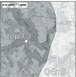
Figure 4. Location of Stop 1-1. Lahore and Belmont 7.5′ quadrangles. SOe—Ellisville granodiorite; OCmII—Mine Run Complex Unit II.
models for the accretion of the Chopawamsic arc to Laurentia. Figure 3 shows a model devised in 2007 (Hibbard et al., 2014) alongside our modifi cations. In the Hibbard et al. (2014) model (Figs. 3A, 3B, and 3C), the accretion of the Chopawamsic arc and Potomac accretionary complex to Laurentia occurred when the Taconic seaway closed. This model supported two phases of Chopawamsic volcanism and a Laurentian affi nity for continen-tal basement beneath the Chopawamsic arc.
Our new data suggest that the Chopawamsic arc may not represent the “Taconic arc” in the southern Appalachians because it was active from 474–465 Ma (with the bulk of magmatism at 470–469 Ma); this span of magmatic ages is during one of the noted magmatic gaps recorded in peri-Laurentian arcs related to the Taconic orogeny in Newfoundland (van Staal et al., 2007). Also, the position of the Storck rocks, with a peri-Gondwanan detrital signature, inboard and to the west of the Chopawamsic terrane suggests that the Chopawamsic arc is peri-Gondwanan.
In our modifi ed model (Figs. 3i, 3ii, and 3iii), we hypothesize that in the Middle Ordovician, the Potomac terrane was proximal to Laurentia, was buried, lithifi ed, intruded, and underwent a fi rst episode of deformation when a Taconic arc (not presently exposed) was accreted to Laurentia. The Chopawamsic arc formed as one continuous phase of volcanism mostly in the Middle Ordovician (474–465 Ma) above a Mesoproterozoic block of Gondwanan crust. The Chopawamsic arc was accreted to Laurentia in the Late Ordovician as Iapetus closed. This event superimposed a second episode of deformation upon some parts of the Potomac terrane. After accretion, the fault was stitched by the Ellisville pluton at ca. 444 Ma; ensuing uplift related to the accretion of Carolinia (see Hibbard et al., 2012b) after the closure of a Cherokee seaway, and subsequent erosion was followed by unconformable deposition of successor basins over the Chopawamsic terrane in the Early Silurian. Our fi gure does not show the presence of allochthonous tectonic slivers along the trace of the Chopawamsic fault; these include the Shores complex (Brown, 1986), the Storck rocks, and potentially other small packages of metasedimentary and meta-mafi c rock that were mobilized along the Chopawamsic fault interface as Iapetus was closing.
LOGISTICS
Some outcrops in this trip have been described by previous workers (Pavlides, 1976, 1989; Horton et al., 2010) but most have not been previously written up in fi eld trip guides. The choice to sample these sites for geochronological analyses and visit them in this trip is twofold: they are easy targets, well described and easily accessed; and many serve as reference locations for the units across the western Piedmont.
Geographic coordinates (WGS-84 coordinate system) and quadrangle locations are listed for each stop. All stops are shown on the geologic map in Figure 2 and a small inset map is shown for each stop as well. Topography in the small inset maps is from 7.5′ USGS quadrangle maps and geology is modifi ed from
Mixon et al. (2000, 2005) and our mapping. No mileage road log
is provided. The total mileage from Stop 1-1 through all interme-diate stops to Stop 2-6 is ~120 miles (193 km).
In the interest of time, some fi eld trip stops listed as optional may be cut from the day’s itinerary. The fi rst day of the fi eld trip will focus on sites to the south of the Rappahannock River while the second day will focus on sites to the north of the river.
■ DESCRIPTION OF STOPS
All stops on the trip, other than roadcuts, are on private land. Proper permission should be obtained to access each stop.
Day 1
Stop 1-1. Ellisville Granodiorite Pluton at Lake Anna 38.1404ºN, 77.8897°W; Lahore Quadrangle (Fig. 4)
Geology, geochemistry, and geochronology of the western Piedmont of northern Virginia 47
A
A
B
C
B
C
D
E
D
E
F
F
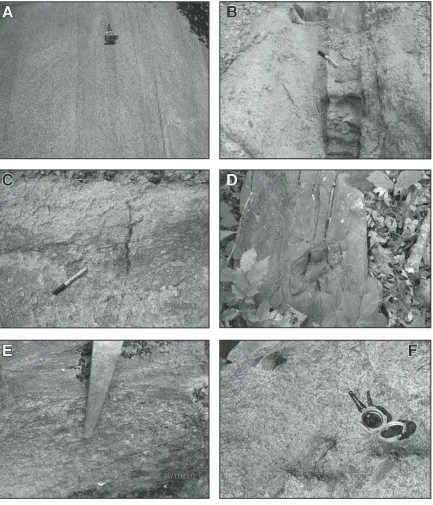
Figure 5. (A) Magmatic fl ow banding at Stop 1-1 in the Ellisville granodiorite. Compass points north and is 7 cm wide. (B) Ash layer within the Chopawamsic Formation at Stop 1-2. Black marker top points north. Marker measures 14 cm long. (C) Volcanic conglomerate within the Chopawamsic Formation at Stop 1-2. Black marker top points north. Marker measures 14 cm long. (D) Rip-up-clast of quartzo-feldspathic graywacke of the Mine Run Complex at Stop 1-6. (E) Con-tact between pebbly and phyllitic bedding in the Mine Run Complex near Stop 1-7. Bedding (048°, vert.) fi nes upward to the southeast and is oblique to foliation (202°, 74° NW). End of rock hammer pick for scale. Location along Wilderness Run at 38.3587°N, 77.7045°W. (F) Fist-sized, fi ne-grained mafi c xenoliths in plagiogranite of the Richland Run pluton near Stop 1-8. Location is on Rapidan River at 38.3658°N, 77.6299°W.
on April 1, 2014 fieldguides.gsapubs.org
!
0 0.25 0.5 0.75 1 Kilometers
Long Branch fault
Chopawamsic
fault
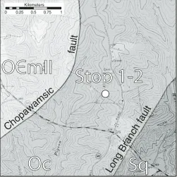
Figure 6. Location of Stop 1-2. Belmont 7.5′ quadrangle. OCmII— Mine Run Complex Unit II; Oc—Chopawamsic Formation; Sq— Quantico Formation.
4.2 Ma (Hughes et al., 2013a). The contact of these two phases in only rarely seen in outcrop, but limited fi eld observations also confi rm that the fi ne-grained phase is younger (Pavlides and Cranford, 1982; Hughes et al., 2013a).
The Ellisville pluton intrudes both the Potomac and Chopawamsic terranes. In this area it is intrusive to the Mine Run Complex of the Potomac terrane but further south it intrudes rocks of the Middle Ordovician Chopawamsic Formation. Thus the Ellisville pluton effectively stitches the Chopawamsic fault and its crystallization age (ca. 444 Ma) can be used as a date of latest possible motion on the fault (Hughes et al., 2013a). Motion on the fault occurred sometime between 465 and 444 Ma.
The epicenter of the M5.8 “Mineral” earthquake that hap-pened on 23 August 2011 is ~25 km to the SSW. This event has resulted in a resurgence of focus upon the Ellisville pluton and some workers (Harrison, 2012) have reported brittle features to exist along the southeast margin of the “tail” of the pluton and interpret them as potential reactivation surfaces. Other work has shown that Paleozoic ductile strain recorded in Chopawamsic Formation rocks to the east of the pluton is spatially coincident with the modern seismogenic surface (Hughes et al., in press).
The main house of the Prospect Hill plantation, just 2 km to the southeast of here, was built in 1812 and now functions as the Littlepage Inn bed and breakfast. Creation of the lake in the early 1970s for the nuclear power plant fl ooded the North Anna River and its local tributaries. At other locations on the property, there remain partially completed mill stones, carved from the local out-crops of Ellisville Granodiorite.
Stop 1-2. Weathered Chopawamsic Formation along Power Line Cut, Brookridge Estates Road
38.1437°N, 77.7955°W; Belmont Quadrangle (Fig. 6)
Although saprolitic, this outcrop (Figs. 5B and 5C) show-cases the heterogeneity of the Chopawamsic Formation. At least four rock types are present within this small outcrop. These include a silty phyllite, a garnetiferous biotite schist, a volca-nogenic conglomerate, and a metamorphosed fi ne ash layer. Graded, vertical bedding strikes 030° and shows the stratigraphic younging direction at this location is to the WNW. Layers such as these in the Chopawamsic “pile” are diffi cult to trace from outcrop to outcrop.
A nearby outcrop of Chopawamsic Formation metasandstone (~5 km to the SW) was sampled for detrital zircon analysis. The collective data from this sample and three other metasedimen-tary samples in the Chopawamsic Formation show a peak mode population at 467 Ma with a small population of 1.0–1.15 Ga zircons (Fig. 7A). The ca. 467 Ma zircons are interpreted to be can-nibalized debris derived from simultaneous volcanism at the time of deposition of the sediments. Therefore, the ca. 467 Ma peak matches known ages for the Chopawamsic Formation (471 Ma, Coler et al., 2000; 474–465 Ma, Hughes et al., 2013b). The Mesoproterozoic zircons are consistent with the Chopawamsic arc being built on top of some form of older continental crust
(Coler et al., 2000). The limited number of older zircons may be due to rapid and voluminous Chopawamsic arc volcanism fol-lowed by subsequent infl ux into and domination of sedimentary systems. The model envisioned for deposition of the sampled metasediments in the Chopawamsic terrane is similar to the intra-arc depositional setting proposed by Cawood et al. (2012).
Stop 1-3. Plentiful Creek Trondhjemite at Sullivan Road 38.1996°N, 77.8201°W; Belmont Quadrangle (Fig. 8)
The rock here was mapped as a block of mylonitic tonalite-granodiorite gneiss covering ~0.45 km2 on the Fredericksburg 30′
× 60′ quadrangle geologic map (Mixon et al., 2000). Surrounded
by phyllite and metasandstone of the Mine Run Complex, this block and others were interpreted to be shed from an approach-ing Chopawamsic arc as it was beapproach-ing accreted to North America (Pavlides, 1989). Importantly, the contact between the country rock and this gneissic block has not been observed. Its gneissic character made it an appealing geochronological target to check for exposed basement in the Potomac terrane.
Geology, geochemistry, and geochronology of the western Piedmont of northern Virginia 49
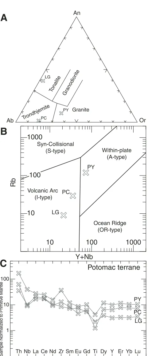
difference between these two plots is that the Ab-An-Or ternary diagram incorporates Na2O (via Ab) into its calculation while the Q-ANOR diagram only uses An and Or values derived from the major oxide chemistry. It is possible that element mobility through metasomatism has altered the original wt% of the major elements, however, the lack of exposure of this rock type makes identifying any potential unaltered compositions diffi cult. On the igneous spectrum of Hughes (1973), this rock plots just outside of the unaltered envelope, near the spillite fi eld. Although a spillite is technically basalt altered by the replacement of CaO by Na2O, its position on the Hughes plot may indicate that similar altera-tion affected this rock if it was originally intrusive into oceanic crust. In support of a case for alteration, the rock contains enough Na2O to be considered Na-altered on a Na2O versus Al2O3/Na2O plot. A sample from this outcrop yields an εNd
(470) value of −1.4,
which is a value that could support formation in a setting with near-CHUR (chondritic uniform reservoir) values. Contradictory to a potential oceanic crust origin, on Pearce et al. (1984) trace-element discrimination diagrams, this sample consistently plots in the volcanic arc granitoid fi eld (Fig. 9B). Trace elements for this sample have been normalized to primitive mantle values of Sun and McDonough (1989) and are shown in Figure 9C. Nega-tive niobium and titanium anomalies are consistent with the vol-canic arc origin as suggested by Figure 9B.
0 50 100 150 200
0 500 1000 1500 2000 2500 3000 3500
Chopawamsic Forma on n= 228
206Pb/238U age = 6 Concordia age = 222
467
Chopawamsic Terranen = 228
206Pb/238U age = 6
Concordia age = 222
0
0 500 1000 1500 2000 2500 3000 3500
Mine Run Com lex n= 385
207Pb/206Pb = 1
206Pb/238U age = 107 Concordia age = 277
1015
0 500 1000 1500 2000 2500 3000 3500
Lunga Reservoir Forma on n= 222
0 500 1000 1500 2000 2500 3000 3500
533
Concordia age = 277
Concordia age = 106 Potomac Terrane
Concordia age = 112
Figure 7. Detrital zircon histogram and probability plots. (A) Chopawamsic Formation. (B) Mine Run Com-plex. (C) Lunga Reservoir Formation. (D) Storck quartzite. Note vertical scales are different in each plot.
0 0.3 0.6 0.9 1.2 Kilometers
y
Figure 8. Location of Stops 1-3 and 1-4. Belmont 7.5′ quadrangle. OCmI—Mine Run Complex Unit I; OCmII—Mine Run Complex Unit II; Opc—Plentiful Creek trondhjemite; Opy—Paytes granite.
on April 1, 2014 fieldguides.gsapubs.org
A sample from this outcrop (KSH-11-17) was selected for U-Pb single-crystal zircon TIMS (thermal ionization mass spec-trometry) analysis. After crushing, separating, and picking, fi ve analyzed zircons have a concordant weighted mean age of 469.5 ± 0.8 Ma (Fig. 10A, 2σ uncertainties include uranium decay constant
uncertainty). The age of this sample alone is compatible with it being shed from the Middle–Late Ordovician Chopawamsic ter-rane but supporting detrital zircon data from the Mine Run Com-plex and correlative Lunga Reservoir Formation (see Stops 1-6, 1-7, and 2-2) indicate no Ordovician or younger debris is present in the Potomac terrane. If a map-scale block were to be shed into a depositional basin, smaller coeval detritus would certainly be pres-ent as well. With these data in mind, we now interpret this body as either an intrusive body or a fault-bounded tectonic sliver.
Stop 1-4 (Optional). Paytes Granite at Craigs Church Road 38.2281°N, 77.8231°W; Belmont Quadrangle (Fig. 8)
The rock here, like the Plentiful Creek body, is also mapped as a block of mylonitic tonalite-granodiorite on the Fredericks-burg 30′ × 60′ quadrangle geologic map (Mixon et al., 2000). It
has been mapped to cover ~0.10 km2 and is the site of a spring in
the headwaters of Robertson Run. Similar to the rock at Stop 1-3, no exposed contact between this granitoid body and the surround-ing Mine Run Complex has been discovered. It was also targeted to test for basement exposure and to test the hypothesis that these bodies represent detrital blocks within the pelitic mélange of the Mine Run Complex (Pavlides, 1989).
This rock is characterized by 61.5% SiO2, 15.3% Al2O3, 1.3% CaO, 4.4% Na2O, and 3.61% K2O. From these composi-tions, fi eld observacomposi-tions, and thin-section analysis, it is evident that this rock is not identical to the rock seen at Stop 1-3; further-more the foliation here is much weaker than that in the Plentiful Creek trondhjemite. The Paytes body falls in the quartz syenite fi eld of the Q-ANOR diagram (Streckeisen and LeMaitre, 1979) and in the granite fi eld of the Ab-An-Or Barker (1979) diagram (Fig. 9A). The rock lies well within the igneous spectrum of Hughes (1973) and shows no signs of Na2O loss or alteration.
On Pearce et al. (1984) trace-element discrimination plots, this rock consistently plots in the within-plate-granite fi eld (Fig. 9B). On a plot of 10,000*Ga/Al versus Zr (Whalen et al., 1987), the Paytes granite plots as an A-type (anorogenic/anhydrous) granite and can be more specifi cally recognized as an A2 type when plotted on the Y-Nb-Ce ternary diagram of Eby (1992). A2 granites are interpreted to be derived of the lower crust and to form in postcollisional settings. A sample from this outcrop yields an εNd
(470) value of −3.3, slightly more evolved than the
Plentiful Creek granitoid. Trace-element concentrations of this sample are normalized to primitive mantle values (Sun and McDonough, 1989) and shown in Figure 9C. This sample shows no niobium anomaly, but does show a negative titanium anomaly and a positive zirconium anomaly.
A sample of the Paytes granite (KSH-12-05) was selected from this outcrop for U-Pb single-crystal zircon TIMS analysis.
Ab Or
An
Granite Gr
anodior ite
Tonalite
Trondhjemite
LG
PC
PY
10 100 1000
10 1000
Rb
Y+Nb
Within-plate (A-type)
Ocean Ridge (OR-type) Syn-Collisional
(S-type)
Volcanic Arc (I-type)
PY
PC
LG
100
1 10 100
Th Nb La Ce Nd Zr Sm Eu Gd Ti Dy Y Er Yb Lu
Sample Nor
maliz
ed to Pr
imitiv
e Mantle
LG PC PY
Potomac terrane
A
B
C
Geology, geochemistry, and geochronology of the western Piedmont of northern Virginia 51
Preliminary results from seven dissolved zircons provide an upper intercept age of 470.1 ± 1.0 Ma (Fig. 10B, 2σ
uncertain-ties include uranium decay constant uncertainty). This age is very similar to the ca. 470 Ma age of the Plentiful Creek trondhjemite seen at Stop 1-3. For reasons explained in the description of Stop 1-3, the Paytes body is also interpreted to represent either a small intrusive body or small tectonic sliver. Three zircon analyses from this body were interpreted to be from inherited zircons; these are all discordant analyses and have 207Pb/206Pb ages of 590 Ma,
1005 Ma, and 1170 Ma. A chord forced through the three anal-yses has a lower concordia intercept of 447 ± 100 Ma and an upper concordia intercept of 1206 ± 93 Ma. The signifi cance of the upper intercept ages depends on the unfounded assump-tion that these three zircons originally crystallized coevally. At minimum, the discordant inherited zircons indicate that the melt that produced this granite body assimilated some form(s) of Neoproterozoic–Mesoproterozoic crust. Mesoproterozoic zir-cons are common in the metasediments of the Mine Run Com-plex (Stops 1-6 and 1-7) that surround the Paytes granite body.
The close proximity (~2.5 km) of two small, coeval gran-itoid bodies (stops 1-3 and 1-4) that have potentially different modes of formation is puzzling. Heterogeneities among the bod-ies in the Mine Run Complex formerly interpreted to be detrital blocks may be circumstantial evidence for tectonic, rather than intrusive, emplacement.
Stop 1-5. Locust Grove Tonalite at Flat Run Farm 38.3249°N, 77.7834°W; Mine Run Quadrangle (Fig. 11)
The rock here is the third and fi nal stop at a body previously interpreted to represent a depositional block in the metaclastic Mine Run Complex (site P-78-11 of Pavlides, 1989). However, this body is much larger than the other interpreted “blocks” and covers ~15 km2. Originally mapped as the Locust Grove granite
by Lonsdale (1927), it was called an altered tonalite/granodiorite on the Fredericksburg 30′ × 60′ quadrangle map (Mixon et al.,
2000) and is mostly weakly to moderately foliated throughout. The rock here contains 64.0% SiO2, 15.5% Al2O3, 4.6% CaO, 3.9% Na2O, and 0.3% K2O. The Locust Grove tonalite at this outcrop plots outside of the igneous spectrum and in the spillite fi eld on the Hughes (1973) diagram; this supports the previous interpretation of alteration. The present composition of the rock falls in the tonalite fi elds of both the Q-ANOR and Ab-An-Or diagrams (Streckeisen and LeMaitre, 1979; Barker, 1979; Fig. 9A). The potential “spillitization” of this rock may indicate it formed in a similar setting as the Plentiful Creek trondhjemite 0.072
0.073 0.074 0.075 0.076
0.555 0.565 0.575 0.585 0.595 0.605
207Pb/235U
(2σ, decay-const. errs included) MSWD (of concordance) = 0.54, Probability (of concordance) = 0.46
error ellipses are 2σ
KSH-11-17
0.555 0.565 0.575 0.585 0.595 0.605
207Pb/235U
(2σ, decay-const. errs included) MSWD (of concordance) = 5.2, Probability (of concordance) = 0.023
error ellipses are 2σ
KSH-12-05
0.52 0.54 0.56 0.58 0.60
207Pb/235U
Upper intercept at 472.6 ± 4.8 Ma
MSWD = 1.5 error ellipses are 2σ
KSH-12-04
Figure 10. Geochronological plots for the Plentiful Creek trondhjemite (A), Paytes granite (B), and Locust Grove tonalite (C) at Stops 1-3, 1-4, and 1-5. Black ellipse represents weighted concordia age. Each ellipse represents the data from one dissolved zircon crystal. White el-lipse with dashed border was not used in the regression calculation for the Locust Grove tonalite.
on April 1, 2014 fieldguides.gsapubs.org
(Stop 1-3). However, also like the Plentiful Creek trondhjemite, on Pearce et al. (1984) trace-element discrimination diagrams, the Locust Grove tonalite consistently plots in the volcanic arc gran-ite fi eld (Fig. 9B). Trace elements normalized to primitive mantle values (Sun and McDonough, 1989; Fig. 9C) display prominent niobium and titanium anomalies, suggesting a supra-subduction zone, or recycled supra-subduction zone, setting (Pearce, 1982; Baier et al., 2008).
This site was sampled (KSH-12-04) for U-Pb single-crystal zircon TIMS analysis. Out of nine dissolved zircons, seven data ellipses defi ne a chord with an upper intercept value of 472.6 ± 4.8 Ma (Fig. 10C, 2σ uncertainties include uranium decay
con-stant uncertainty). If U-decay uncertainties are ignored, the error reduces to ± 2.4 Ma. The two analyses not included in the inter-cept calculation are one analysis that lies slightly off the line and a very discordant zircon with a 206Pb/238U age of ca. 890 Ma, a 207Pb/235U age of ca. 1120 Ma, and a 207Pb/206Pb age of ca. 1590 Ma.
The ca. 473 Ma crystallization age for the Locust Grove body shows that all three granitoid bodies sampled in the Mine Run Complex have identical crystallization ages, within analytical uncertainties. However, it remains unclear if they formed in simi-lar tectonic settings.
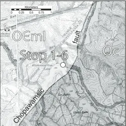
Stop 1-6. Mine Run Complex Unit I at Wilderness Dam 38.3096°N, 77.7365°W; Chancellorsville Quadrangle (Fig. 12)
This site was used by Pavlides (1989) as one of the reference locales for Mine Run Complex Unit I. This is his site P-77-34,
!
0 0.25 0.5 0.75 1 Kilometers
Lake of the Woods
Figure 11. Location of Stop 1-5. Mine Run 7.5′ quadrangle. Olg— Locust Grove tonalite; OCmII—Mine Run Complex Unit II; OCmIII —Mine Run Complex Unit III.
which he describes as a “fi ne-grained, weakly foliated, poorly sorted, feldspathic graywacke.” This location also has been more recently described by Terblanche and Nance (2012). The rock consists of fi ne–medium-sized grains of quartz, plagioclase, muscovite, biotite, and chlorite. Most areas of the Mine Run Complex matrix rocks have considerably less feldspar than this location. In this outcrop, and a few nearby, there are small (up to fi st-sized) rip-up clasts of identical composition material within the sedimentary matrix (Fig. 5D).
A sample of this rock (KSH-11-05) was collected for detrital zircon analysis. Three hundred and eighty-fi ve acceptable analy-ses from this and three other samples of the Mine Run complex (Fig. 7B) show that this rock was dominantly derived from a Mesoproterozoic source area. These results are consistent with a regional, Laurentian source area of crystalline rocks—some of which would have formed during the Grenville orogeny. A concordant 499 ± 15 Ma (2σ uncertainty) zircon represents the
youngest zircon analyzed from this outcrop and is the youngest zircon analyzed from all samples of the Potomac terrane in our study (Hughes et al., 2012a). A ca. 500 Ma zircon in a sample of the correlative Lunga Reservoir Formation (Stop 2-2) provides additional credibility to the lone 499 Ma zircon in this sample. These ca. 500 Ma and other Cambrian–Ediacaran zircons help to delimit the age of deposition of the components of the Potomac terrane. Taken into account with the 472 Ma Occoquan granite (Aleinikoff et al., 2002) that intrudes the Potomac terrane to the north, it appears that the Mine Run Complex was deposited
!
0 0.25 0.5 0.75 1 Kilometers
Chopawamsic
fault
Geology, geochemistry, and geochronology of the western Piedmont of northern Virginia 53
offshore of Laurentia sometime between 500–470 Ma, during Late Cambrian to Early Ordovician.
The lack of detritus in any samples (n = 6 samples, n = 607 analyses) of the Potomac terrane that is similar in age to the Mid-dle Ordovician Chopawamsic terrane metavolcanics to the east suggests that the Mine Run Complex was not derived from the Chopawamsic arc (Hughes et al., 2013b). It seems unlikely that all potential zircon from the Chopawamsic arc could have been selectively removed based upon hydraulic sorting in the hydro-logic system feeding the Potomac terrane depositional basin. Pavlides (1989) interpreted the Mine Run Complex rocks to have been partially shed from, and deposited ahead of, the Chopawam-sic arc as it approached North America. However he noted that “it is striking that volcanic metagraywacke has not been found in any [part of the Mine Run complex], considering the potential detrital source area of the [Chopawamsic] volcanic-arc terrane that lies immediately east.” The detrital zircon results presented here indi-cate that there are not volcaniclastic strata in the Mine Run Com-plex because its sediment was not derived of the Chopawamsic arc, rather it was already deposited, buried, intruded, and poten-tially metamorphosed by the time of Chopawamsic arc volca-nism (ca. 474–465 Ma).
Stop 1-7 (Optional). Mine Run Complex Unit I at Eley’s Ford, Rapidan River
38.3575°N, 77.6850°W; Chancellorsville Quadrangle (Fig. 13)
This outcrop in the east bank of Eley’s Ford Road is another example of Unit I of the Mine Run Complex. It was also a stop in a recent fi eld trip led by Terblanche and Nance (2012). This outcrop is ~170 m from another reference outcrop for Mine Run Complex I, which is down on the Rapidan River (Pavlides, 1989, site P-70-152). The rock here is more typical of the rest of the Mine Run Complex than the relatively feldspar-rich composition seen at Stop 1-6. While it is mostly well-foliated phyllite, there are also pebbly layers present. These pebbly layers are common in this area of the Mine Run Complex and have been best recog-nized along the lower reaches of Wilderness Run, ~2 km to the west (Fig. 5E). The rounded, fi ne–medium-grained clasts include quartz with minor feldspar. In some areas the quartz includes dis-tinct blue quartz.
A mixed sandy and pebbly layer at this location was selected for detrital zircon analysis (sample P310-4). Similar to the feld-spathic graywacke at Stop 1-6, and all other samples in the Mine Run Complex, most of the zircons in this sample are Mesopro-terozoic (Fig. 7B).
Stop 1-8 (Optional). Richland Run Pluton at Hunting Run Reservoir Dam, Spotswood Furnace Road
38.3537°N, 77.6388°W; Chancellorsville Quadrangle (Fig. 14)
The dam and most of the reservoir is underlain by the Rich-land Run pluton. There is good outcrop of the pluton just north of Spotswood Furnace Road in a small drainage to the west of
!
0 0.25 0.5 0.75 1 Kilometers
fault
Figure 13. Location of Stop 1-7. Chancellorsville 7.5′ quadrangle. OCmI—Mine Run Complex Unit I; Oc—Chopawamsic Formation; Orr—Richland Run pluton.
!
0 0.25 0.5 0.75 1 Kilometers
Hunting Run Reservoir
Figure 14. Location of Stop 1-8. Chancellorsville 7.5′ quadrangle. Oc—Chopawamsic Formation; Orr—Richland Run pluton; Sq— Quantico Formation.
on April 1, 2014 fieldguides.gsapubs.org
the main channel of Hunting Run (this area may be very over-grown!). The rock here, and in much of the Richland Run pluton, contains common xenoliths of fi ne-grained mafi c material (Fig. 5E), potentially derived of the Garrisonville mafi c complex.
A sample of the rock here contains 74.6% SiO2, 14.8% Al2O3, 2.0% CaO, 5.6% Na2O, and 0.8% K2O. This composition plots as a trondhjemite on the Ab-An-Or ternary plot of Barker (1979) and a tonalite on the Q-ANOR diagram of Streckeisen and LeMaitre (1979).
The 89-ft-tall Hunting Run dam was built in 2002 and the reservoir behind it covers 420 acres and contains 3.1 billion gal-lons of water used to supply Spotsylvania County.
Day 2
Stop 2-1. Garrisonville Mafi c Complex at Vulcan Stafford Quarry
38.4844°N, 77.4483°W; Stafford Quadrangle (Fig. 15)
The Stafford Vulcan quarry is an active pit mine with large machinery and dangerous quarry walls. Please stay on the safe side of constructed berms. All other safety measures and instructions from your hosts should be strictly followed.
This quarry is the best site to see exposures of almost all phases of the Garrisonville mafi c complex. Most phases of the complex are metamorphosed mafi c rocks and Pavlides (1990, 1995) interpreted it to represent a preserved fragment of oceanic
crust that existed between the Chopawamsic arc and the Lau-rentian craton. Contacts with surrounding Chopawamsic terrane rocks are not exposed, but it appears that intrusive rocks of the Chopawamsic arc intrude the Garrisonville complex.
Phases of the Garrisonville complex include (from oldest to youngest, excluding phase 6):
(1) a fi ne-grained meta-basalt which seems to be the most voluminous and oldest of the phases,
(2) a medium-grained meta-gabbro that commonly occurs in association with the fi ne-grained meta-basalt,
(3) a pervasive medium-grained granodiorite-tonalite that almost everywhere includes fragmental xenoliths of the fi ne- and/or medium-grained meta-gabbro phases, (4) a fi ne–medium-grained felsite that appears to be
younger than the granodiorite-tonalite phase, but doesn’t contain xenoliths,
(5) an aphanitic mafi c dike set that appears to be the young-est and least voluminous phase present in the quarry, and (6) a dark green porphyritic ?actinolite-tremolite ultramafi c?
rock that only has been observed in the western area of the complex, not in the vicinity of the Vulcan quarry. The age relationship of this phase to other phases is unknown. Geochemical analyses from mafi c phases (excluding the ?actinolite-tremolite ultramafi c? phase) of the Garrisonville com-plex show a subalkaline basalt signature when plotted on SiO2 versus alkali and trace-element plots (LeBas et al., 1986; Win-chester and Floyd, 1977; Pearce 1996; Fig. 16A). These phases contain 41%–52% SiO2, 13%–17% Al2O3, 9%–21% Fe2O3(T), 5%–13% MgO, 10%–13% CaO, 0%–3% Na2O, 0.1%–0.5% K2O, and 0%–4% TiO2. Trace-element concentrations normal-ized to primitive mantle values (Sun and McDonough, 1989) are shown in Figure 16B. The two felsic phases present are geo-chemically similar to felsic volcanics of the Chopawamsic For-mation (Fig. 16A).
A sample of the medium-grained granodiorite-tonalite (KSH-12-32) was taken from the quarry for geochronological analysis. Five single-grain analyses of dissolved zircons yield a concordant age of 467.7 ± 1.0 Ma (Fig. 17A, 2σ uncertainties
with uranium decay uncertainty included); no zircon analyses from this sample are indicative of xenocryst inheritance.
A sample of the fi ne–medium-grained felsite (KSH-12-33) was also taken for geochronological analysis. Out of seven analy-ses, fi ve cluster for a concordia age of 469.1 ± 0.6 Ma (Fig. 17B, 2σ uncertainties with uranium decay uncertainty included). The
two remaining data ellipses are slightly discordant, likely a result of Pb loss from the crystals analyzed. Like the granodiorite sam-ple, no inherited zircons were found in the felsite sample.
The results from the geochemical and geochronological anal-yses from the felsic phases in the Garrisonville complex indicate it was intruded by magmatism similar in composition and age to the Chopawamsic volcanics. It seems that if the mafi c phases of the complex represent a preserved piece of oceanic crust, it was likely obducted onto or otherwise amalgamated with the Chopawamsic arc by the time of bulk Chopawamsic plutonism and volcanism
!
!
0 0.25 0.5 0.75 1 Kilometers
S?g
fault
S?g
Geology, geochemistry, and geochronology of the western Piedmont of northern Virginia 55
(ca. 474–465 Ma). The likely intrusive relationship between the Richland Run pluton and the Garrisonville complex (Pavlides, 1995; Mixon et al., 2000) supports this interpretation.
The age(s) of the mafi c components of the Garrisonville complex is/are not known at this time. The ca. 468–469 Ma intrusive dike systems only provide a youngest possible age for the rocks they intrude. The ca. 474 Ma age of one phase of the Richland Run pluton (Stop 2-4), which appears to intrude the Garrisonville complex, likely pushes back the youngest possible age of the Garrisonville complex even more. Two samples of the meta-gabbroic phase yield εNd
(475) values of −3.3 and 0.01. If
calculated at 500 Ma, the values only increase to −3.2 and 0.2.
.001 .01 .1 1 10
Chopawamsic intermediate to felsic
volcanic and intrusive rocks
n = 17
A
B
C
Figure 16. Geochemical data for the Chopawamsic terrane. (A) Zr/TiO2 versus SiO2 plot after Winchester and Floyd (1977). Bas—basalt; Trach—trachyte; Neph—nepheline; Sub-Alk— subalkaline. (B) Trace-element data comparing mafi c rocks of the Garrisonville complex to primitive mantle values of Sun and Mc-Donough (1989). (C) Trace-element data comparing intermediate to felsic magmatic rocks of the Chopawamsic terrane to primitive mantle values of Sun and McDonough (1989).
0.072 0.073 0.074 0.075 0.076
0.555 0.565 0.575 0.585 0.595 0.605
207Pb/235U
(2σ, decay-const. errs included) MSWD (of concordance) = 1.6, Probability (of concordance) = 0.20
error ellipses are 2σ
KSH-12-33
0.555 0.565 0.575 0.585 0.595 0.605
207Pb/235U MSWD (of concordance) = 1.7, Probability (of concordance) = 0.19
error ellipses are 2σ
Figure 17. Geochronological plots for granodiorite (A) and felsite (B) that intrude mafi c rocks of the Garrisonville complex at Stop 2-1. Black ellipse represents weighted concordia age. Each ellipse repre-sents the data from one dissolved zircon crystal. White ellipses with dashed borders were not used in the age calculation.
on April 1, 2014 fieldguides.gsapubs.org
In the quarry, there exists a mineral alteration zone associ-ated with a steeply dipping fault roughly oriented from north to south. This feature is likely a Mesozoic structure and was not a focus of our study.
Stop 2-2. Lunga Reservoir Metadiamictite Formation at Beaverdam Run, Quantico Marine Corps Base
38.5049°N, 77.4317°W; Joplin Quadrangle (Fig. 15)
This site, previously written up in a fi eld guide (Pavlides, 1976), is one of the reference outcrops used to defi ne the Lunga Reservoir Formation and has been termed a “biotite-muscovite-quartz-plagioclase granofels (schist-chip feldspathic metagray-wacke)” (site P-72-6; Pavlides, 1989). The Lunga Reservoir lies ~2 km to the NW upstream on Beaverdam Run. The Lunga Res-ervoir and related Sykesville formations were both once thought to represent igneous plutons. The rock here was mapped by Lons-dale (1927) as the “Later Granite,” perhaps due to the very weak, or often lack of, foliation. This rock was mapped as a pluton on the 1963 geologic map of Virginia as well (Milici et al., 1963) but Southwick et al., (1971) redefi ned the rock as “massive nonlay-ered and weakly foliated medium- to coarse-grained feldspathic biotite-muscovite” pebbly gneiss.
We adhere to the description of the formation as a meta-diamictite (Pavlides, 1989), a metamorphosed sedimentary rock that consists of poorly sorted clasts and pebbles in a fi ner-grained matrix. The clasts most commonly present in outcrops of the Lunga Reservoir Formation are rounded pebble–cobble-sized vein quartz clasts (referred to as quartz lumps by Pavlides, 1989), and similar sized dark schist “chips.” The matrix is a mix of mostly fi ne-grained quartz, feldspar, muscovite, and biotite. In some places, there is mostly matrix with very few clasts. The presence of the preserved schist clasts indicates that the deposi-tional center for the Lunga Reservoir Formation was relatively close to the sedimentary source. Unlike the Mine Run Complex, we have found no compositional layering or bedding features in the Lunga Reservoir Formation.
A sample (KSH-11-18) from this outcrop was selected for detrital zircon analysis. Two hundred and twenty-two analyses from this sample and a second of the Lunga Reservoir Formation are shown in Figure 7C. These results confi rm that the Lunga Reservoir metadiamictite is a metamorphosed sedimentary rock that was derived from mostly Mesoproterozoic rocks. The results from these samples are quite similar to the cumulative prob-ability of ages of detrital zircons from the Sykesville Formation (206Pb/238U data from Horton et al., 2010, shown on Fig. 7C as
dashed line). These results reinforce the interpretation that the Lunga and Sykesville formations represent correlative units (Pavlides, 1989).
The youngest grain from these two samples has a concordia age of 502 ± 18 Ma (2σ uncertainty). This age is similar to the
youngest zircon present from all samples of the Mine Run Com-plex (ca. 499 Ma)—see Stop 1-6. The detrital zircon results from samples of the Lunga Reservoir Formation are consistent with
!
0 0.25 0.5 0.75 1 Kilometers
Long Branch fault
Figure 18. Location of Stop 2-3. Storck and Stafford 7.5′ quadrangles. Oc—Chopawamsic Formation; Ogb—gabbro body; Orr—Richland Run pluton; Sq—Quantico Formation.
the interpretation that it is a part of the composite Potomac ter-rane and derived of Laurentian crust.
However, there are some differences between the detrital signature seen in the Lunga Reservoir Formation and those seen in the Mine Run Complex. Detrital zircons in the Lunga sam-ple show much more concentration in older (ca. 1.25–1.60 Ga) Mesoproterozoic zircons than the zircons analyzed from samples of the Mine Run Complex—compare plots in Figures 7B and 7C. Pavlides (1989) suggested that the Lunga and Sykesville for-mations were derived from a fragment of presently unexposed Precambrian Laurentian crust he referred to as “Sykesvillia,” while the debris in the Mine Run Complex was a more mature and well-mixed sediment. Our results are consistent with differ-ent (but both Laurdiffer-entian) source areas for the Lunga Reservoir Formation and Mine Run Complex. However, we are cautious with any interpretations based upon the abundance of zircons of different ages in our samples. Alternatively, the higher concentra-tion of 1.25−1.60 Ga zircons in samples of the Lunga Reservoir
Formation could be a result of zircon sorting in the sedimentary systems at work during the time the samples were deposited.
Stop 2-3. Chopawamsic Felsic Volcanics at Long Branch Reservoir (Abel Lake)
38.4132°N, 77.4968°W; Stafford Quadrangle (Fig. 18)
Geology, geochemistry, and geochronology of the western Piedmont of northern Virginia 57
the Geological Society of America (Pavlides, 1976). The guide for that trip depicted rocks at this stop as part of the Chopawam-sic Formation, but later mapping (Pavlides, 1990, 1995; Mixon et al., 2000) showed them as part of the Quantico Formation to the east. The most recent mapping (Mixon et al., 2005) once again shows this site as part of the Chopawamsic Formation and we adhere to this latest interpretation.
It is also the sample site of one of the two total U-Pb zircon geochronological samples taken from the Chopawamsic Forma-tion prior to our study—Horton et al. (2010) report a 206Pb/238U
SHRIMP (sensitive high-resolution ion microprobe) age of 453 ± 4 Ma for the felsic volcanic near here. This Late Ordovician date, combined with a previously determined Middle Ordovician 471.4 ± 1.3 Ma (Coler et al., 2000) date in the Chopawamsic Formation has led to the proposition of two discrete phases of Chopawamsic volcanism (Horton et al., 2010; Sinha et al., 2012; Hibbard et al., 2014).
The rock has been described as a fi ne-grained metafelsite (Horton et al., 2010) and a metarhyolite (Pavlides, 1976). Close inspection shows quartz phenocrysts in a fi ne-grained quartz rich matrix. Our sample from this outcrop contains, among other oxides, 75.9% SiO2, 12.5% Al2O3, 1.4% CaO, 3.7% Na2O, and 2.4% K2O. The chemistry and mineralogy of this rock and other sampled felsic volcanics in the Chopawamsic Formation are con-sistent with that of a rhyolite (Fig. 16A). Trace-element data for this sample and 16 others in the Chopawamsic terrane are nor-malized to primitive mantle values (Sun and McDonough, 1989) and are shown in Figure 16C.
Although initially collected only for whole-rock studies, we have since performed single crystal dissolution geochronological analysis on a sample from this outcrop (KSH-11-21). After sev-eral other collected Chopawamsic Formation samples were found to be devoid of zircon, a portion of this sample was processed and found to include plentiful zircon. The subsequent on-the-fl y goal of “re-dating” this outcrop was to provide better resolution on the most important age to come out of the Chopawamsic Forma-tion; although fewer crystals are analyzed with the TIMS method than the SHRIMP method, the individual results are more pre-cise. Nine individual zircons were dissolved; four contained little radiogenic Pb and have large errors associated with them. Of the remaining fi ve, four cluster for a concordant age of 465.4 ± 0.7 Ma (2σ uncertainties with uranium decay constant
uncertain-ties included, Fig. 19A). The fi fth analysis shows signs of Pb loss and plots below the concordia line on the Wetherill diagram.
The ca. 465 Ma age obtained by our study does not match the ca. 453 Ma age obtained by Horton et al. (2010). Based upon the resolution of the TIMS method, our use of both 206Pb/238U
Figure 19. Geochronological plots for the Chopawamsic Formation (A) and Richland Run composite pluton (B and C). Black ellipse rep-resents weighted concordia age. Each ellipse reprep-resents the data from one dissolved zircon crystal. White ellipses with dashed borders were not used in the age calculation.
0.072 0.073 0.074 0.075 0.076
0.555 0.565 0.575 0.585 0.595 0.605
207Pb/235U
error ellipses are 2σ
KSH-11-21
Chopawamsic Felsic Volcanic
465.4 ± 0.7 Ma
(2σ, decay-const. errs included) MSWD (of concordance) = 3.6, Probability (of concordance) = 0.058
Stop 2-3
0.555 0.565 0.575 0.585 0.595 0.605
207Pb/235U
error ellipses are 2σ
473.8 ± 0.6 Ma
(2σ, decay-const. errs included) MSWD (of concordance) = 1.4, Probability (of concordance) = 0.24
KSH-12-02
0.555 0.565 0.575 0.585 0.595 0.605
207Pb/235U
Upper intercept at
468.9 ± 5.6 Ma
MSWD = 0.19 error ellipses are 2σ
and 207Pb/235U ages, and the overwhelming amount of Middle
(not Late) Ordovician material dated in the Chopawamsic ter-rane by our study (Hughes et al., 2013b) and a previous study (Coler et al., 2000), we feel that the ca. 465 Ma age is accurate. The argument that the TIMS method may “mix” crystalliza-tion and inherited ages if a single crystal records two or more growth episodes is not valid here. It is improbable that four ran-domly selected individual zircons with mixed ages would yield identical concordant (not intercept) ages. The 465 Ma age also serves to reinforce that this outcrop is part of the Chopawam-sic Formation, not the overlying Quantico Formation just to the east. The revision of the age of this rock eliminates the need for a two-phase Chopawamsic arc model. This work also serves to emphasize the importance of high-precision TIMS dating of magmatic rocks.
Stop 2-4. Chopawamsic Fault Splay between Storck Rocks and Richland Run Pluton at King Daniels Way
38.4352°N, 77.6237°W; Storck Quadrangle (Fig. 20)
The geology in the vicinity of the Storck rocks has recently been re-mapped by North Carolina State University graduate student Dillon Nance and this stop has also been detailed in a previous fi eld trip guide (Terblanche and Nance, 2012). The most detailed mapping prior to our study was done by Karen Wier of the U.S. Geological Survey in the late 1970s (Wier, 1977).
! !
0 0.25 0.5 0.75 1 Kilometers
Chop
aw
amsic
fault
Figure 20. Location of Stops 2-4 and 2-5. Richardsville and Storck 7.5′quadrangles. Ogv—Goldvein pluton; Orr—Richland Run pluton; OCsg—Storck granitoid body; OCsp—Storck phyllite; OCsq— storck quartzite.
South of King Daniels Way, there exists a large “wall” exposure within the “Storck rocks” of silty phyllite with foliation oriented at 194°/82°NW. Just, upstream, there is saprolitic, ~4-m-thick, dark-green mafi c phyllite that is interlayered with the silty phyl-lite. Beyond this mafi c phyllite, which we interpret to be part of the package of Storck rocks, is the contact with the Richland Run composite pluton. The exact contact is not exposed but can be estimated to lie within a very short interval of a few feet. The Richland Run pluton is well foliated here and all along its west-ern margin. We interpret this contact to be part of the ductile Chopawamsic fault system, rather than a nonconformity as pre-viously mapped (Pavlides, 1990, 1995; Mixon et al., 2000). The faulted relationship between the Storck rocks and the Richland Run pluton is also supported by the increase in the intensity of the tectonic fabric from east to west in the Richland Run plu-ton, even through multiple phases of the pluton. In its type area along Richland Run, the Richland Run pluton is a nonfoliated, medium-grained, and equigranular tonalitic rock with nonmodi-fi ed crystal boundaries (Fig. 21A) while similar composition rock of the pluton from ~1.3 km north of this stop shows signs of considerable foliation development, grain-size reduction, and feldspar crystal modifi cation (Fig. 21B).
One hundred and seven analyzed detrital zircons from a sample of the Storck rocks show different age distributions than data from the Quantico and Arvonia Formations (Bailey et al., 2008; Hughes et al., 2013b) it was previously thought to be cor-relative with (Pavlides, 1995; Mixon et al., 2000); the sample of the Storck rocks (KSH-1140) chosen for analysis shows that it received detritus from a source area that consisted of material aged from 2.0 Ga to ca. 500 Ma (Fig. 7D). Peak modes occur at 533 Ma, 607 Ma, 978 Ma, 1.15 Ga, and 1.33 Ga. While dis-similar to the Quantico and Arvonia system, the detrital signal in the Storck sample is comparable to that of the Shores mélange (Bailey et al., 2008), which lies ~100 km along strike to the southwest. Both the Shores and Storck rocks appear to be alloch-thonous tectonic slivers that received either peri-Gondwanan or mixed peri-Gondwanan and Laurentian detritus.
The Richland Run pluton is composite in nature and crops out over an area of ~85 km2. Wier (1977) mapped part of the
pluton and subdivided it into plagiogranitic and tonalitic mem-bers. Both phases commonly include fi st-sized mafi c xenoliths, potentially derived from the Garrisonville mafi c complex. Sub-sequent mapping has since depicted the entire mass as a single plagiogranite body (Mixon et al., 2000). In our mapping we have recognized the same phases as Wier and sampled each for geochronological analysis. A sample from the far western (pla-giogranitic) phase (KSH-12-02) yields a concordant zircon U-Pb age of 473.8 ± 0.6 Ma (2σ uncertainties with uranium decay
con-stant uncertainties considered, Fig. 19B). A sample (KSH-12-23) from the type area along Richland Run is from the tonalitic phase and yields an upper-intercept age of 468.9 ± 5.6 (2σ uncertainties
Geology, geochemistry, and geochronology of the western Piedmont of northern Virginia 59
of the Richland Run pluton is the oldest portion of the pluton. The ca. 474 Ma age from that phase also serves to provide further age control on the Garrisonville complex, which appears to be intruded by the phases of the Richland Run pluton.
Stop 2-5 (Optional). Storck Rocks along Deep Run, South of Thompson’s Mill Road
38.4493°N, 77.6300°W; Richardsville Quadrangle (Fig. 20)
Fine-grained, greenish phyllite crops out in the west bank of Deep Run here. The dominant orientation of the foliation here is 188°/80°NW, but there are small, gentle to open folds present within the foliation. Folding of foliation indicates that the Storck
1 mm
A
B
A
B
Figure 21. Photomicrographs of the Richland Run pluton. (A) Weakly foliated, equigranular plagiogranite. (B) Well- foliated plagiogranite with grain-size reduction. Neither thin section is oriented.
rocks have experienced at least two deformational events. The relationship between the phyllite here and phyllite farther to the north between the Lunga Reservoir Formation and the Goldvein pluton (see Fig. 2) is unknown.
Stop 2-6 (Optional). Goldvein Granite at Deep Run, Blackwells Mill Road
38.4862°N, 77.6401°W; Richardsville Quadrangle (Fig. 22)
The Goldvein pluton covers ~80 km2, has been dated at 456
± 9 Ma (Aleinikoff et al., 2002), and intrudes Mine Run Complex rocks of the Potomac terrane. The mostly weakly foliated pluton also appears to intrude the Storck rocks as its eastern margin, although the contact has not been directly observed, and we have observed no intrusive dikes in the Storck rocks. Just as the Gold-vein pluton obscures the contact between the Storck rocks and the Mine Run Complex, it also obscures the northern boundary of the Mine Run Complex. Although the contacts with surrounding rocks have not been observed, we are confi dent in the extent of the map boundaries of the Goldvein pluton due to its resistance to weathering and resultant abundance of outcrop.
A sample from this location was collected for whole-rock Sm-Nd isotope analysis and yields an evolved εNd
(456) value
of −5.2. Comparison of isotopic characteristic from units that
probe basement rocks to either side of the Chopawamsic fault will aid in the fi nal assessment of the affi nity of the Chopawam-sic terrane.
!
0 0.25 0.5 0.75 1 Kilometers
Figure 22. Location of Stop 2-6. Richardsville 7.5′ quadrangle. Ogv— Goldvein pluton; OCsp—Storck phyllite.
on April 1, 2014 fieldguides.gsapubs.org